CHAPTER 4 - SITE SELECTION PROCESS FOR
HURRICANE EVACUATION ANALYSIS
Introduction
By combining results from the literature
review and the canvass of public and private hurricane evacuation operations
initiatives, a set of factors that could greatly influence the selection of
sites to Beta test the hurricane evacuation model were developed.
Profile
of North Carolina's Key Attributes for Hurricane Evacuation Analysis
Geographical
Characteristics
The State of North Carolina has a total
area of 52,712 square miles and is divided into four physiographic provinces
(Tidewater Coastal Plain, Upper and Middle Coastal Plain (UMCP), Piedmont, and
the Mountains). The Coastal Plain land
and water areas comprise nearly half the area of the State. The Tidewater portion is generally flat and
swampy while the interior is gently sloping and, for the most part, well
drained. The Piedmont portion rises
from the 200-foot level to near 1500 feet at the base of the mountains. The land is mostly gently rolling hills with
a great deal of hard rock near the surface. Also, the Piedmont comprises about
one third of the State. Lastly, the
Mountains comprise the smallest area covering a little more than one fifth of
the State [24].
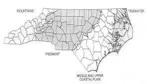
Figure 4.1 - State of
North Carolina Physiographic Provinces
Climatic
Conditions
North Carolina enjoys a mild but varied
climate owning to its wide range in elevations and to inland areas' distance
from the sea. The average temperature varies more than 20 degrees from the
lower coast to the highest mountains.
The average annual rainfall of 80 inches in the southwestern mountains
is the greatest in the eastern United States.
East of the mountains, average annual rainfall is 40 to 55 inches. Winter storms, generally approaching from
the southwest, are triple threats for North Carolina. Depending on their exact tracks, they deliver heavy snow, severe
icing or heavy rain and sometimes cause flooding. The entire state is susceptible to frontal and air mass
thunderstorms. On average, North Carolina
experiences 14 tornadoes per year.
These storms might occur at any time, but are most likely in the spring
and summer months. During each
hurricane season (June - November), the North Carolina coast likely will be
threatened, if not struck, by at least one tropical storm. For climate purposes, North Carolina is
divided into 8 regions and they are: (1) Southern Mountains; (2) Northern
Mountains; (3) Northern Piedmont; (4) Central Piedmont; (5) Southern Piedmont;
(6) Southern Coastal Plain; (7) Central Coastal Plain; and (8) Northern Coastal
Plain [24].
Demographic
Information
North Carolina's overall population is
estimated at over 7.7 million spreads over a total land area of slightly more
than 31 million acres. Approximately
one third of the State's total population lives in the Coastal Plain; however;
the population is not evenly distributed throughout the area. Most of the Coastal Plain population is
concentrated in the southern section where the major military installations are
located. Even though the Piedmont
physiographic province is one-third the State's total area, over one half the
State's population resides in this area.
The population concentrated in the Piedmont Crescent, a large, loosely
defined area that stretches from Charlotte through the Statesville,
Winston-Salem, Greensboro-High Point area, and Burlington to the
Raleigh-Durham-Chapel Hill area. The
Mountain region is the smallest and least populated section in the State. About fifteen percent of the State's
population lives in the mountain region [24].
Moreover, residents age 65 or older
represent approximately 12.1 percent of the State's total population. Residents that are disable, living in
households without personal vehicles, or are beneficiaries of social security
represents approximately 6.8 percent, 9.6 percent, and 20 percent of North
Carolina's population, respectively.
Transportation
Infrastructure
Vital to North Carolina's economy is their transportation network. The network consists of airports (public and private), ferries, ports, public transportation (buses, vanpools, etc.) operating in rural and urban areas, rail (passenger and freight), roads (Interstate, State routes and US routes), and a few miles of navigable waterway corridors. While each element of the State's transportation infrastructure network is important, the road system and public transportation system are more heavily relied upon during a hurricane evacuation then any of the other travel modes. Within North Carolina, there is approximately 78,000 miles of roadways. The primary highways total mileage is 14,616 and it consist of 12 Interstate Highways, 226 State routes, and 74 US route. Total mileage for the secondary roads is 63,467. With regard to public transportation systems, there are more than 100 urban and rural properties operating throughout the state. There are 18 public-owned, urban transit systems and about four million North Carolinians have access to rural public transportation services operating throughout the 100 counties. Clearly, the need to maintain adequate, well-maintained roadways, bridges along all routes, and capitalize on the use of public transportation is key to not only providing direct access to emergency shelter locations, but also facilitating an evacuation response to severe weather and other civil emergencies.
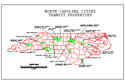
Figure 4.2 - North
Carolina Public-Owned Public Transportation Systems
Site Selection Criteria
In the wake of Hurricane Floyd, 66 counties in North Carolina were declared disaster area by FEMA. Over 227 shelters in addition to motels, etc. were used by more than 100,000 people.
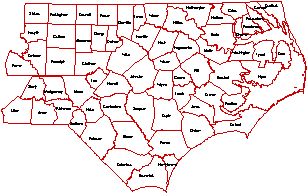
Figure 4.3 - Counties Declared Disaster Areas
The report identified some
potential evacuation sites that may benefit from a coordinated evacuation
planning effort that takes advantage of transit vehicles. Some of the criteria for site selection
include:
1. Small urban and rural areas;
2. At risk of flooding and/or other hurricane threats;
3. Located entirely in the Tidewater or Piedmont areas (see below);
4. Captive population, i.e., low income, elderly, handicapped, etc.;
5. With transit service somewhere nearby;
6. Availability of demographic information; and
7.
Evacuation was deemed necessary during Floyd.
Based on the guidelines presented, a number of potential sites were identified by:
· Literature review through hundreds of websites, news articles, government reports, and anecdotal stories to identify townships, areas, counties in North Carolina with records of flooding and other difficulties during Floyd.
· Identification of the locations of the at-risk areas to insure the selection of those in the Tidewater or Piedmont areas.
· Identification of locations not identified specifically in news but otherwise fitting to the criteria.
· Compilation of a list of 10-candidate analysis sites.
The results of the effort and solicited input and suggestions formed the basis for the final selection of the two eventual project sites.
Candidate Sites and Final Selection
After painstaking search of flooding areas due to hurricanes, more than fifty locales were identified and tabulated in alphabetical order in the Table 4.2. Unfortunately, most of these locations fall in the MUCP region. Only four areas were eligible, based on the selection criteria, to be considered as candidate sites. This prompted the question of whether Criterion 3: Located entirely in the Tidewater or Piedmont areas, which was identified on the previous page, was needed. The following ten sites will attempt to reflect the original criteria. It will be interesting to study the entire state in a follow up study in which Criterion 3 is eliminated and a broader definition for areas of interest is used.
Table 4.1 - Initial
Compilation of Candidate Sites
|
Site |
Description |
Notes |
|
1 |
Princeville |
·
Highest “hit” rate in the news ·
In MUCP area, however! ·
Severe flooding ·
Low income |
|
2 |
Elizabeth City |
·
In Tidewater area ·
Had tornado and flooding problems ·
May be an urban area |
|
3 |
Louisburg |
·
In Piedmont area ·
Record flood during Floyd |
|
4 |
Warrenton |
·
In Warren Co. within Piedmont area ·
Unsure about flooding problem |
|
5 |
Norlina |
·
In Warren Co. within Piedmont area ·
Unsure about flooding problem |
|
6 |
Weeksville |
·
In Tidewater area ·
Unsure about flooding and evacuation problem |
|
7 |
Columbia |
·
In Tyrrell Co. within Tidewater area ·
Unsure about flooding and evacuation problem |
|
8 |
Zebulon |
·
In Wake Co. within Piedmont area ·
Unsure about flooding and evacuation problem |
|
9 |
Rocky Mount |
·
High “hit” rate in the news ·
In MUCP area, however! |
|
10 |
Greenville |
·
High “hit” rate in the news ·
In MUCP area, however! |
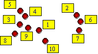
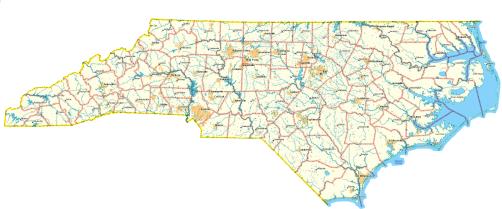
Figure 4.4 - Location of Initial Candidate
Sites