CHAPTER 6 - ENABLING ITS USED IN
HURRICANE EVACUATION OPERATIONS
Introduction
Intelligent
Transportation Systems, or ITS, is applying communications technology to
resolve today's transportation problems.
In an effort to improve safety and efficiency, the State of North
Carolina is looking toward a broad range of diverse technologies to provide
innovative solutions to specific immediate and long-term transportation
management needs confronting the state. The purpose of chapter is to provide a
brief overview of NCDOT ITS efforts, recommended ITS and non-ITS applications
resulting from Hurricane Floyd [29], and the use of ITS applications in
hurricane evacuation operations resulting from the case study findings.
Overview of ITS in North Carolina
NCDOT
is the lead agency in drafting a Statewide ITS Strategic Deployment Plan. The overall focus is to guide deployment of
ITS in a manner that will result in an integrated, cost-effective plan that
will increase motorist safety and security, preserve infrastructure and
services, ensure transportation system efficiency, and increase economic
development opportunities throughout the state. Currently, there are ten ITS regions (see Figure 6.1 [21,22])
defined in North Carolina. They are
Asheville, Coastal Rural, Fayetteville, Interstate 95 Corridor, Metrolina,
Mountains Rural, Piedmont (northern and southern areas), Triad, Triangle, and
Wilmington. Tables 6.1 - 6.4 provides a
listing of agencies comprising each region and the email address to NCDOT
regional representative.
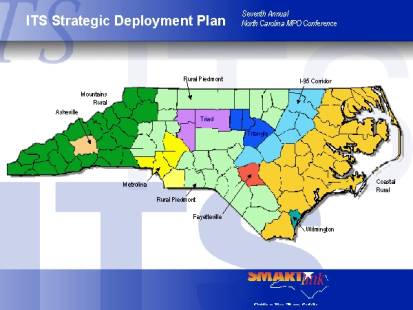
Figure 6.1 - Location of ITS Regions
Table 6.1 - Agencies Participating in Regional ITS
Efforts
|
Asheville |
Coastal |
Fayetteville |
|
City of Asheville |
Cities of Greenville, SC;
Jacksonville, FL; Wilmington, NC |
City of Fayetteville |
|
Buncombe County |
Counties: Bertie,
Brunswick, Camden, Chowan Craven, Curritack, Duplin, Gates, Hertford, Jones,
Lenor, Martin, Onslow, Pamlico, Pender, Perquimans, Sampson, Wayne |
Cumberland County |
|
NCDOT |
NCDOT |
Fort Bragg Military
Reservation |
|
North Carolina Highway
Patrol (NCHP) |
NCHP |
NCDOT |
|
North Carolina Department
of Motor Vehicles (NCDMV) |
NCDMV |
NCHP |
|
Tennessee Department of
Transportation |
Virginia Department of
Transportation |
NCDMV |
|
Federal Highway
Administration (FHWA) |
Virginia Highway Patrol |
FHWA |
|
Institute for
Transportation Research &
Education (ITRE) |
FHWA |
ITRE |
|
Local Law Enforcement (LLE) |
Port Authority |
LLE |
|
Local Emergency Response
(LER) |
ITRE |
LER |
|
Land of Sky Regional
Council |
LLE |
Mid Carolina Council of
Governments |
|
Asheville Area Chamber of
Commerce |
LER |
|
Source [21, 22]
Table 6.2 - Agencies Participating in Regional ITS
Efforts
|
I-95 |
Metrolina |
Mountains |
|
City of Rocky Mount |
Cities of Charlotte,
Concord, Gastonia |
Counties: Alleghany, Ashe,
Avery, Burke, Caldwell, Cherokee, Clay, Cleveland, Graham, Haywood,
Henderson, Jackson, Macon, Madison, McDowell, Mitchell, Polk, Rutherford,
Swain, Tancey, Transylvania, Watauga, Wilkes |
|
Counties: Cumberland,
Edgecombe, Halifax, Harnett, Johnston, Nash, Northampton, Robertson, Wilson |
Counties: Anson, Cabarrus,
Mecklenburg, Union |
NCDOT |
|
NCDOT |
Charlotte Metropolitan
Transit Commission |
NCHP |
|
NCHP |
NCDOT |
NCDMV |
|
NCDMV |
NCHP |
Tennessee Department of
Transportation |
|
SCDOT and Virginia
Department of Transportation |
NCDMV |
Tennessee Highway Patrol |
|
Virginia Highway Patrol |
SCDOT |
FHWA |
|
FHWA |
South Carolina Highway
Patrol |
ITRE |
|
ITRE |
FHWA |
LLE |
|
LLE |
ITRE |
LER |
|
LER |
LLE |
|
|
|
LER |
|
Source [21, 22]
Table 6.3 - Agencies Participating in Regional ITS Efforts
|
Piedmont |
Triad |
|
|
Northern Region |
Southern Region |
Cities: Burlington,
Greensboro, High Point, Winston-Salem |
|
Counties: Alexander,
Catawba, Davie, Eden, Franklin, Granville, Iredell, Linkoln, Oxford, Person,
Reidsville, Rockingham, Stokes, Vance, Warren |
Counties: Anson, Bladen,
Chatham, Columbus, Hoke, Lee, Montgomery, Moore, Randolph, Richmond,
Roberson, Scotland, Stanly, Union |
Counties: Alamance,
Davidson, Forsyth, Guilford, Rowan |
|
NCDOT |
NCDOT |
Winston-Salem Transit
Authority |
|
NCHP |
NCHP |
Greensboro Transit
Authority |
|
NCDMV |
NCDMV |
Hi Tran |
|
Virginia Department of
Transportation |
Virginia Department of
Transportation |
Piedmont Triad, Northwest
Piedmont, and Centralina Councils of Government |
|
Virginia Highway Patrol |
Virginia Highway Patrol |
NCDOT |
|
FHWA |
FHWA |
NCHP |
|
ITRE |
ITRE |
NCDMV |
|
LLE |
LLE |
ITRE |
|
LER |
LER |
LLE |
|
|
|
LER |
Source [21, 22]
Table 6.4 - Agencies Participating in Regional ITS
Efforts
|
Triangle |
Wilmington |
|
Cities: Durham, Chapel
Hill, Raleigh |
City of Wilmington |
|
Counties: Durham, Orange,
Wake |
New Hanover County |
|
NCDOT |
NCDOT |
|
NCDMV |
NCHP |
|
FHWA |
NCDMV |
|
ITRE |
ITRE |
|
LLE |
LLE |
|
LER |
LER |
|
Triangle Council of
Government |
Cape Fear Council of
Government |
Source [21, 22]
Moreover,
current ITS applications deployed throughout the state include coordinated
signal systems, high occupancy vehicle (HOV) lanes, highway advisory radios
(HAR), reversible lanes, traffic cameras, traffic signals, and variable message
signs (VMS). Complementing these
integrated systems is North Carolina's Incident Management Assistance Patrol
(IMAP) and TIMS traveler information services.
Together, all these systems offer a more efficient, seamless and
sophisticated transportation infrastructure.
Hurricane Floyd: Recommended ITS
Applications and Non-ITS Solutions
In
the June 2000 PBS&J Study, several ITS applications and non-ITS solutions
were identified and recommended for future NCDOT NCEMD usage based on lessons
learned during Hurricane Floyd. During
Hurricane Floyd, the Raleigh area was the major destination for evacuees from
all over the eastern part of the state and from South Carolina. Table 6.5
highlight proposed locations along three key evacuation routes (Interstate 40,
440, and 95) that are considered to be strategically positioned to provide
aerial surveillance information, disseminate traffic information to travelers,
and provide incident management system services. The aerial surveillance
operations will be conducted by the North Carolina State Highway Patrol (NCSHP)
OH-58 helicopter crews to capture minimum weather flying information to display
via close circuit television (CCTV), count stations, and weather states. Dynamic message signs (DMS) and HARs are
recommended tools to be used to alert travelers about road closures, openings,
reentry, etc. Similarly, it is recommended that NCDOT continue to use the IMAP
to assist disable motorists, direct traffic around incidents, and clear debris
along the roadway. This has a strong
potential to augment the DMS and HAR efforts.
Lastly, traffic management centers will continue to operate on the
premise of sharing data and video information with other regional traffic
management centers throughout the state as well as providing back-up control
during periods when other centers are not manned.
Table 6.5 - North Carolina ITS Recommendations
|
Route |
Direction |
Location |
County |
CCTV |
HAR |
DMS |
Count Station |
Weather Station |
|
I-40 |
|
Rest Area |
Duplin |
X |
X |
|
|
|
|
I-40 |
Eastbound |
West of I-95 |
Johnston |
X |
X |
X |
|
|
|
I-40 |
Westbound |
South of I-95 |
Johnston |
X |
|
X |
X |
X |
|
I-40 |
|
South of US 70 |
Johnston |
X |
|
X |
|
|
|
I-40 |
Westbound |
South of NC 96 |
Johnston |
X |
X |
X |
X |
|
|
I-40 |
|
Cape Fear River |
New Hanover |
X |
|
|
|
X |
|
I-40 |
|
NC 132 |
New Hanover |
X |
X |
X |
X |
|
|
I-40 |
|
US 117 |
Sampson |
X |
|
|
|
|
|
I-40 |
|
South of NC 403 |
Sampson |
X |
|
X |
|
|
|
I-40 |
|
South of NC 701 |
Sampson |
|
|
X |
|
|
|
I-40 |
|
US 70 |
Wake |
X |
|
|
X |
|
|
I-440 |
|
I-40 (South of
Raleigh) |
Wake |
X |
|
|
|
|
|
I-440 |
|
US 401 |
Wake |
X |
|
|
|
|
|
I-440 |
|
US 1 (West of
Raleigh) |
Wake |
X |
|
X |
|
|
|
I-440 |
|
I-40 (West of
Raleigh) |
Wake |
X |
|
|
|
|
|
I-440 |
|
US 70 (South of
Raleigh) |
Wake |
X |
|
|
|
|
|
I-440 |
|
US 401 (East of
Raleigh) |
Wake |
X |
|
|
|
|
|
I-440 |
|
US 70 (North of
Raleigh) |
Wake |
X |
|
|
|
|
|
I-440 |
|
US 1/64 (East
of Raleigh) |
Wake |
X |
X |
X |
|
|
|
I-440 |
|
US 401 (South
of Raleigh) |
Wake |
X |
|
|
|
|
|
I-440 |
|
Us 64 (Apex) |
Wake |
X |
|
|
|
|
|
I-95 |
Northbound |
South of NC 59 |
Cumberland |
|
|
X |
|
|
|
I-95 |
|
NC 59 |
Cumberland |
X |
|
|
|
|
|
I-95 |
|
NC 24 |
Cumberland |
X |
|
|
|
|
|
I-95 |
Northbound |
South of US 301 |
Cumberland |
X |
X |
X |
X |
|
|
I-95 |
Northbound |
South of US 401 |
Harnett |
|
|
X |
|
|
|
I-95 |
Northbound |
South of US 421 |
Harnett |
X |
|
X |
|
|
|
I-95 |
Southbound |
North of I-40 |
Johnston |
X |
|
X |
|
|
|
I-95 |
|
South of I-40 |
Johnston |
X |
|
X |
|
|
|
I-95 |
|
US 64 |
Nash |
X |
X |
|
|
|
|
I-95 |
|
US 74 |
Roberson |
X |
|
X |
|
X |
|
I-95 |
|
NC 211 |
Roberson |
X |
|
|
|
|
|
I-95 |
|
US 264 |
Wilson |
X |
|
|
|
X |
Source [29]
The
non-ITS solutions suggest that the state should arrange with private operators
to ensure fuel is available and restaurants are open during the critical
evacuation period. It was noted that
during the Hurricane Floyd evacuation, the lack of motorist's services and
restrooms were a problem in North Carolina and in other states due to the high
demand and extended travel times. Also,
NCDOT is directed to make efforts to have to their rest areas and welcome
centers open during the evacuation period as well.
Moreover, some pertinent comments were generated from meetings held between the PBS&J study team, NCDOT, and NCSHP. These comments are valuable in helping to develop hurricane evacuation operation plans for multiple agencies. A few of the comments are listed below:
Table 6.6 - North Carolina Non-ITS Recommendations
|
North Carolina
Department of Transportation |
North Carolina
State Highway Patrol |
|
County
plans address regional problems. |
Develop
information needs pertinent to the nature of evacuees (local residents vs.
tourists). |
|
Address
shelter information using traveler information systems. |
Shoulders should be reserved for use by emergency
vehicles, disable vehicles, and law enforcement access. |
|
Consider
use of shoulder as a travel lane. |
Shelters should have signs. |
|
Install
cable guardrail in median to prevent cross median head-on accidents. |
Consider using staged evacuations to assist with
managing traffic better. |
|
Develop
special event signal timing plans. |
Consider
having mandatory evacuation. |
|
Develop
long-range plan for traffic management centers in Asheville,
Durham/Raleigh/Research Triangle area, Charlotte, Fayetteville,
Greensboro/High Point/Winston-Salem area, and Wilmington. |
|
Source [29]
Case Study Findings: Recommended ITS
Applications
In
the event of a hurricane evacuation, a key concern is to combine all available
resources in order to assist those in need. When modeling the network for each
case study site, the likely traffic management approach that would mitigate
congestion was the use of the reverse lane approach. An analysis of the results indicated the presence of congestion
earlier in the evacuation on some of the links in Elizabeth City (no congestion
was observed at any time in Louisburg).
The introduction of reverse lane strategy effectively eliminated the
congestion and brought the simulated results in line with expected hurricane
evacuation times. However, the reverse
lane strategy alone was not able to dissipate the congestion in the event a
toxic gas was released into the atmosphere.
For this type disaster, the simulation model indicated EETs of 3 hours
and 4 minutes for Elizabeth City and 2 hours and 16 minutes for Louisburg. Elizabeth City, under these conditions,
showed severe congestion on some links.
Louisburg, showed only mild congestion on some of the links, especially
in the beginning of the evacuation.
Therefore, a combination of reverse lanes and the deployment of policemen to direct traffic at key intersections were analyzed. For Elizabeth City reverse lanes were simulated on Halstead Boulevard and on West Ehringhaus Street. The policemen would be deployed at the intersections of South Hughes Boulevard and West Ehringhaus Street (node 13 on Figure 5.1), Halstead Boulevard and West Ehringhaus Street (node 25), Hughes Boulevard and Well Field Road (node 49), and Hughes Boulevard and US Highway 158 (node 57). With these traffic strategies deployed, the simulation showed an EET of 2 hours and 21 minutes (a decrease of almost 25% in the evacuation time), with significant reductions in congestion (see Figure 5.13).
For
Louisburg, a reverse lane strategy on US Highway 401 south bound was analyzed
along with deployment of policemen at the intersections of US Highway 401 and
State Route 561 (node 53 on Figure 5.2) and US Highway 401 and State Route 56
(node 49). With these traffic
strategies deployed, the congestion disappeared completely (see Figure 5.14).
Next,
bus trips were introduced to evacuate certain sectors of the population (e.g.,
the elderly and disable) that otherwise would not be able to evacuate by their
own means. It was assumed that the
buses would depart from a garage, arrive at an assigned pickup point, load the
evacuating population, and follow a predetermined route to exit the network at
node 1 (Figure 5.15). The results show generally that for loading times of 20,
25, and 30 minutes, the optimal departing times from the garage are at 10, 10,
and 0 minutes AOE, respectively. The
simulation also shows that the worst time to depart is 40 minutes AOE. This represent an increase in en-route
travel time of 134%, 141%, and 128% for loading times 20, 25, and 30
minutes. When compared to the optimal
en-route times except for pick up points 2101 (Figures 5.18, 5.19 and Table
5.2) and 2049 (Figures 5.20, 5.21, and Table 5.3) that has the worst departure
time of 30 minutes. Again, the
congestion levels Elizabeth City and Louisburg were not significantly affected
by the scheduling of buses within the network using the assumption as stated
earlier.
Indeed, ITS applications derived from this study are
very much in accordance with NCDOT ITS Strategic Deployment Plan. These
solutions along with others, such as the 5-1-1, service sign-up, and ride matching
initiatives will definitely improve the mobility and accessibility of elderly
and disable citizens during a time of evacuation.