
MARYLAND I-270 INTEGRATED CORRIDOR MANAGEMENT
(ICM)
CONCEPT OF OPERATIONS
STAGE 1 FINAL
![]() You will need the Adobe
Reader to view the PDFs on this page.
You will need the Adobe
Reader to view the PDFs on this page.
PDF (2.4 MB)
March 31, 2008
FHWA-JPO-08-002
EDL Number 14388
Submitted to:
U.S. Department of Transportation
Federal Highway
Administration
Federal Transit Administration
Research and Innovative
Technology Administration
Notice and Quality Assurance Statement
Technical Report Documentation Page
1.1 Introduction and Document Contents
1.2 ICM Corridor Boundaries, Networks and Stakeholders
1.3 Corridor operating and institutional conditions
1.4 Need and Potential for Integrated Corridor Management
1.5 ICM Vision, Goals and Objectives
1.6 ICM Operational Framework, Approaches, and Strategies
1.7 ICM Concept Operational Description
1.8 Required Assets and ICM Implementation Issues
1.9 I-270 Corridor ICM Concept Institutional Framework
3. EXISTING CORRIDOR SCOPE AND OPERATIONAL CHARACTERISTICS
3.1 Corridor Boundaries and Networks
3.3 Operational Conditions of the I-270 Corridor and Included Networks
3.4 Existing Network-Based Transportation Management/ITS Assets
3.5 Proposed Near-Term Network Improvements
3.6 Current Network Based Institutional Characteristics
3.7 Regional ITS Architecture Review
3.9 Potential for ICM in the I-270 Corridor
4. ICM SYSTEM OPERATIONAL CONCEPT
4.1 Corridor Goals and Objectives
4.4 Application of ICM Approaches and Strategies
4.5 ICM Concept Asset Requirements and Needs
4.6 Comparison of ICM Concept Asset Requirements with Current and Potential Assets
4.7 I-270 Corridor Concept Operational Description
4.8 Alignment With Regional ITS Architecture
4.10 ICM Corridor Institutional Framework
4.11 Performance Measures and Targets
TABLE OF FIGURES
Figure 3-1. I-270 Montgomery County ICM Corridor
Figure 3-2. I-270 ICM Corridor Detector Locations
Figure 3-3. I-270 ICM Corridor HAR, DMS, CCTV, and RWIS Locations
LIST OF TABLES
Table 1-1. I-270 Corridor Stakeholders
Table 1-2. Critical Needs of the I-270 Corridor
Table 1-3. I-270/Montgomery County Corridor Goals and Objectives for ICM
Table 1-4. Proposed ICM Approaches and Strategies for the I-270 Corridor
Table 1-5. Additional Required Assets for ICM Implementation
Table 3-1. I-270 Corridor Network Characteristics
Table 3-2. I-270 Corridor Stakeholders
Table 3-3. Average Annual Daily Traffic and Level of Service on I-270
Table 3-4. MD-355 Average Annual Daily Traffic
Table 3-5. Connector Route Annual Average Daily Traffic
Table 3-6. Average Metrorail Weekday Ridership in the I-270 Corridor
Table 3-7. Metrobus Average Weekday Boardings per Trip
Table 3-8. Average Weekday Ridership on Selected Ride On Routes
Table 3-9. Network-Based Transportation Management/ITS Assets
Table 3-10. I-270 Corridor Critical Needs
Table 4-1. I-270/Montgomery County Corridor Goals and Objectives for ICM
Table 4-2. Relationship Between I-270 ICM Corridor Needs and Goals
Table 4-3. Proposed ICM Approaches and Strategies for the I-270 Corridor
Table 4-4. Relationship between I-270 ICM Operational Strategies and Corridor Goals
Table 4-5. I-270 Corridor Market Packages
Table 4-6. I-270 Corridor Communications Infrastructure
Table 4-7. I-270 Corridor Asset Requirements
Table 4-8. I-270 Corridor Market Packages
Table 4-9. I-270 Corridor Communications Infrastructure
Table 4-10. I-270 Corridor Asset Requirements
Table 4-11. Summary of Significant Changes and Additions to the I-270 Corridor
Table 4-12. I-270 ICM Implementation Issues
Table 4-13. I-270 ICM Baseline Performance Measures and Targets
Table 4-14. Sample Potential Performance Measure Targets
Table 5-1. Daily Operational Scenario
Table 5-2. Scheduled Event Scenario
Table 5-3. Minor Traffic Incident Scenario
Table 5-4. Major Traffic Incident Scenario
1. SCOPE AND SUMMARY
1.1 Introduction and Document Contents
This document presents the Concept of Operations (ConOps) for an Integrated Corridor Management (ICM) system along the Interstate-270 Corridor in Montgomery County, Maryland. The document offers a user-oriented view of the system concept. It progresses logically from a discussion of characteristics and conditions in the corridor, to an examination of the corridors transportation operational needs, to identification of an integrated management concept for addressing those needs. It concludes with consideration of a series of operational scenarios.
-
Scope and Summary,
-
References,
-
Existing Corridor Scope and Operational Characteristics,
-
ICM System Operational Concept, and
-
Operational Scenarios.
This document was prepared jointly for the Federal Highway Administration and Federal Transit Administration, under the Integrated Corridor Management Program (Cooperative Agreement No. DTFH61-06-H-00042). It was prepared by the Maryland Department of Transportation in association with Montgomery County and the Washington Metropolitan Area Transit Authority. The University of Marylands Center for Advanced Transportation Technology and Telvent Farradyne Inc. assisted with the preparation of this report.
1.2 ICM Corridor Boundaries, Networks and Stakeholders
The I-270 Corridor is located in Montgomery County, Maryland just outside Washington, D.C. The corridor measures approximately 20 miles in length and consists of a variety of transportation networks, including:
-
The Freeway Network (including I-270),
-
The Arterial and Connector Route Network (including MD-355),
-
The MARC Commuter Rail Network,
-
The Metrorail Network,
-
The MTA Commuter Bus Network,
-
The Metrobus Network, and
-
The Ride On Network.
A map of the I-270/Montgomery County Corridor is presented in Figure 3-1 (see Section 3.1). The major boundaries of the corridor include the following:
-
Northern Boundary The Frederick County/Montgomery County Line;
-
Southern Boundary I-495 (Capital Beltway);
-
Western Boundary South to north: River Road, Falls Road, Wooten Parkway, Great Seneca Highway, and the MARC Brunswick Line; and
-
Eastern Boundary South to north: Viers Mill Road, MD-355, Shady Grove Road, Airpark Road, and Woodfield Road.
The corridor is part of the broader Metropolitan Washington Council of Governments (MWCOG) region.
Key stakeholders in the I-270 Corridor are identified in Table 1-1, below:
Table 1-1. I-270 Corridor Stakeholders
|
Partnering Agencies Agencies partnering for Phase I of the U.S. DOTs Discretionary Cooperative Agreement for Integrated Corridor Management include:
Stakeholders Other agencies with a stake in the outcome of the U.S. DOTs Discretionary Cooperative Agreement for Integrated Corridor Management of the I-270 Corridor include:
|
1.3 Corridor Operating and Institutional Conditions
The I-270 Corridor, also referred to as the Technology Corridor, links significant suburban residential concentrations with the major employment regions of Northern Virginia, downtown Washington, D.C., the Capital Beltway, and along the I-270 Corridor itself. As with most urban areas in the United States, the trend in the Metropolitan Washington, D.C. area has been that development expands outward from the city. However, most commuters in the I-270 Corridor are not heading into Downtown Washington, but to other suburban locations. Because of high-traffic volumes in the corridor, and the impact that incidents even outside the corridor can have on I-270 conditions, congestion has become a monumental problem.
Some of the current operating conditions in the I-270 Corridor are:
-
The interstate highway, I-270, runs at full capacity during peak hours.
-
The only viable alternative paralleling I-270 is MD-355.
-
The Maryland Transit Administration (MTA) provides commuter rail service (MARC) along the I-270. The MARC Brunswick Line serves approximately 2,524 riders during the AM peak and a total of 5,047 riders daily, operating only in peak periods, in the peak direction.
-
The WMATA Metrorail Red Line serves commuters in the I-270 Corridor. The Red Line is WMATAs busiest line. Morning peak travel moves predominantly in the direction of downtown Washington, D.C., whereas the afternoon peak moves from Washington towards the Maryland suburbs.
-
WMATAs Metrobus provides the much needed east-west link within the I-270 Corridor. Montgomery County runs the Ride On system within the corridor. There is opportunity to add ridership to these bus services.
-
The agencies with formal responsibility for operating one or more networks within the I-270 Corridor are:
-
Maryland State Highway Administration (MDSHA) Management of the freeway network and Park-n-Ride facilities along I-270.
-
Montgomery County Department of Public Works and Transportation (DPWT) Management of the countys arterial network, as well as the Ride On bus service.
-
Maryland Transit Administration (MTA) Operation of MARC train service.
-
Washington Metropolitan Area Transit Authority (WMATA) Operation of Metrorail and Metrobus, and managing parking facilities at stations.
-
Maryland State Police Enforcement, security, and accident investigations on freeways.
-
Montgomery County Police Enforcement, security, and accident investigations on Montgomery County arterials.
-
City of Rockville Management of the arterial network in Rockville.
-
City of Gaithersburg Management of the arterial network in Gaithersburg.
-
University of Marylands Center for Advanced Transportation Technology (CATT) Maintenance and operation of the Regional Integrated Transportation Information System (RITIS) prototype.
The partner agencies involved in the Montgomery County I-270 Integrated Corridor Management initiative are represented on the National Capital Region Transportation Planning Board (NCR/TPB), which is the federally-designated metropolitan planning organization (MPO) for the region.
1.4 Need and Potential for Integrated Corridor Management
The I-270 the corridor is highly directional and connects most commuters with their work place locations, either in Washington D.C., Northern Virginia, Maryland, or within Montgomery County itself. During rush hour, the commuter volume routinely exceeds capacity. In addition, unplanned events, such as incidents within or outside the corridor, can impact the transportation system, producing large-scale travel delays, secondary incidents, etc. There is a need to expand corridor-wide information sharing to help disseminate reliable and real-time traveler information to the commuters.
The other modes available to the commuters in the corridor are the MARC commuter train, WMATA Metro Rail and bus system and the Montgomery County Ride On bus system. The MARC commuter train makes only eight stops in the corridor. The Metrorail system has many stops serving many commuters, but only extends to Shady Grove, which is roughly halfway down the corridor. Many commuters using Metrorail must either park and ride at the station or take Ride On or Metrobus to the rail stations, thus adding more time to their commutes.
The critical needs of the corridor are summarized in Table 1-2, below.
Table 1-2. Critical Needs of the I-270 Corridor
|
Incident and Emergency Management |
|
Issue: Non-recurring congestion is a monumental impediment to mobility in the corridor. Needs:
|
|
Traffic Signals |
|
Issue: Traffic signals in the corridor are often not optimized for conditions. Needs:
|
|
Transit and Commuter Management |
|
Issue: Transit services in the corridor are often inconvenient for rush-hour commuters. Needs:
|
|
Traveler Information |
|
Issue: Travelers often do not have sufficient information about roadway, traffic, and transit conditions to make informed travel decisions. Needs:
|
|
Infrastructure |
|
Issue: Infrastructure limitations sometimes impair responsiveness to changing traffic and congestion conditions. Needs:
|
1.5 ICM Vision, Goals and Objectives
Vision: In the future, transportation operations within the I-270/Montgomery County corridor function at peak efficiency by optimizing the use of the capacities of the different transportation modes within the corridor. Key technology systems and decision support tools within the corridor are interoperable and real-time information on road and traffic conditions is commonly exchanged among the corridors managing partners and stakeholders. Operational strategies within the corridor are routinely adjusted in response to changing corridor conditions. Strategic management of the corridor emphasizes multi-modalism, and commuters have flexible access to real-time transit and parking lot information. Travelers are apprised of current road surface, traffic, and transit conditions pre-trip and en-route; this information is then used to make informed travel and routing decisions. Performance metrics are employed across the corridor to assess variations in efficiency and safety benchmarks, refine the existing approaches, and formulate and deploy follow-on operational strategies.
To further this vision, four ICM goals have been identified:
-
Optimize mobility, reliability, and safety;
-
Strengthen corridor-level decision support;
-
Enhance reliable, real-time information to customers; and
-
Promote multi-modalism.
Table 1-3, below, specifies the objectives associated with each goal.
Table 1-3. I-270/Montgomery County Corridor Goals and Objectives for ICM
|
Goals |
Objectives |
|---|---|
|
Optimize Mobility, Reliability, and Safety: Achieve the highest practical levels of mobility through the corridor. Maximize mobility and minimize delays associated with incidents and other non-recurring conditions. Make the travel experience more predictable and reliable so that day-to-day fluctuations in travel times are less extreme. Optimized performance, with less volatility and reduced exposure to adverse conditions, will affirmatively impact safety. |
|
|
Strengthen Corridor-Level Decision Support: Upgrade the information-exchange infrastructure to more quickly put more comprehensive, fact-based information on incidents and roadway conditions in the hands of responders, traffic managers, and other stakeholders. Furnish tools that support adept decision making resulting in faster response and clearance. |
|
|
Enhance Reliable, Real-Time Information to Customers: The precepts here are two-fold: (1) travelers deserve to be informed about roadway/transit conditions and circumstances; and (2) as travelers are kept apprised of conditions, they will be empowered to make intelligent choices and thereby be active agents in optimizing mobility. |
|
|
Promote Multi-Modalism: Promote reductions in the volume of vehicles traversing the corridor by making transit and carpooling more attractive to customers. Even for those travelers who loathe to permanently abandon single-occupant vehicle travel, encourage ad hoc shifts to alternative modes as conditions warrant. |
|
1.6 ICM Operational Framework, Approaches, and Strategies
Five specific ICM approaches, all building on existing initiatives, are anticipated:
-
Prototype and deploy the Regional Integrated Transportation Information System (RITIS).
-
Optimize traffic signals on arterials.
-
Deliver computer-aided dispatch/automatic vehicle location (CAD/AVL) information to transit users.
-
Deliver parking space availability information to commuters.
-
Measure operations performance.
The specific operational strategies associated with each of the five ICM approaches are shown in Table 1-4, below.
Table 1-4. Proposed ICM Approaches and Strategies for the I-270 Corridor
|
Prototype and Deploy Enhanced RITIS |
|
|
Optimize Traffic Signals on Arterials |
|
|
Deliver CAD/AVL Status Information to Transit Users |
|
|
Deliver Parking Availability Information to Commuters |
|
|
Measure Operations Performance |
|
1.7 ICM Concept Operational Description
The proposed operational enhancements to the I-270/Montgomery County Corridor are intended to improve the efficiency by optimizing the use of capacities within the transportation modes and the reliability of travel along the corridor. The daily operation of the corridor will remain very similar to the current operations executed by each stakeholder agency. Each agencys system will have an interface to RITIS, which will allow the automatic input of relevant data. RITIS, in turn, will automatically provide each agencys system with information regarding the operational status of the assets from other agencies.
The integration of the I-270 ICM corridor is designed to be done very quickly without requiring major institutional modifications or major construction projects and be deployable within a short period of time. Corridor response plans will be developed by a joint effort among all of the stakeholders and implemented within each agency. RITIS will support the generation of performance measures reports.
RITIS will link to existing (and potentially new) venues for disseminating information to the general public. The information is expected to be more comprehensive, reliable, and timely than are the data currently available. Motorists will be able to make smarter, better-informed decisions both pre-trip and en-route. In particular, travelers will have access to information that may make usage of transit services more attractive to them.
The I-270 Corridor will function as an integrated transportation system to benefit travelers and users.
1.8 Required Assets and ICM Implementation Issues
The I-270 ICM corridor is a mature corridor with various agencies in the corridor having deployed systems for transportation management. Hence, many of the assets required for I-270 specific integrated corridor management (ICM) are already deployed or are in the process of being deployed. The I-270 ICM approach builds on this existing infrastructure and initiatives in the region such as RITIS, which was initially conceived as a metropolitan-wide system, or other initiatives that are progressing without a more corridor-wide focus. Table 1-5, below, shows the additional assets which will be required for a successful ICM implementation. Each items projected completion date is listed in parentheses.
Table 1-5. Additional Required Assets for ICM Implementation
|
Network |
Stakeholder |
Changes and Additions |
|---|---|---|
|
Freeway Network |
Maryland State Highway Administration (MDSHA) |
|
|
Arterial Network |
Montgomery County Department of Public Works and Transportation (DPWT) |
|
|
MARC Commuter Rail Network |
Maryland Transit Administration (MTA) |
|
|
Metrorail Network |
Washington Metropolitan Area Transit Authority (WMATA) |
|
|
Metrobus Network |
Washington Metropolitan Area Transit Authority (WMATA) |
|
|
Ride On Network |
Montgomery County Department of Public Works and Transportation (DPWT) |
|
1.9 I-270 Corridor ICM Concept Institutional Framework
The goal for institutionalizing an I-270 ICM structure will be to utilize established regional frameworks instead of creating an entirely new structure. Weaving the I-270 ICM initiative into the fabric of the current regional ITS, operations, and management institutional frameworks makes sense from a resource perspective. This will also help integrating the I-270 ICM-related projects into existing planning and funding processes. It will also make use of the synergy between the goals and initiatives of the various regional ITS, operations, and management groups and the I-270 ICM initiative by using the I-270 ICM initiative as a test bed for ITS strategies being considered at a broader regional level.
2. REFERENCES
References Specific to the I-270 Corridor
-
2004 Performance of Regional High-Occupancy Vehicle Facilities on Freeways in the Washington Region, Metropolitan Washington Council of Governments, National Capital Region Transportation Planning Board, July 2005.
-
CHART Business Plan, Draft Document (Unpublished), Maryland State Highway Administration, Office of CHART and ITS Development, November 2006.
-
CHART Non-Constrained Deployment Plan, Maryland State Highway Administration, Office of CHART and ITS Development, April 2005.
-
Freeway Incident Traffic Management for I-270, Maryland State Highway Administration, Office of CHART and ITS Development, May 2006.
-
Montgomery County DPWT Traffic Signal Modernization Project Draft Concept of Operations, Montgomery County Department of Public Works and Transportation, Siemens ITS, RGA Inc., and T3 Design,C., February 2007.
-
Performance Evaluation and Benefit Analysis for CHART, Maryland State Highway Administration, Office of CHART and ITS Development, and University of Maryland, Center for Transportation Technology, May 2006.
-
Regional Integrated Transportation Information System (RITIS): Draft Concept of Operations, University of Maryland, Center for Transportation Technology, and Volpe National Transportation Systems Center, January 2007.
-
Maryland Intercounty Connector (ICC), overview and summary information available at http://www.rita.dot.gov/cgi-bin/ExitPage/good_bye.cgi?url=http://www.iccproject.com/index.php.
General References for Integrated Corridor Management
-
Develop Criteria for Delineating a Corridor, Report No. FHWA-JPO-06-035, U.S. Department of Transportation, ITS Joint Program Office, April 2006.
-
ICM Implementation Guidance, Report No. FHWA-JPO-06-042 U.S. Department of Transportation, ITS Joint Program Office, April 2006.
-
ICMS Concept of Operations for a Generic Corridor, Report No. FHWA-JPO-06-032, U.S. Department of Transportation, ITS Joint Program Office, April 2006.
-
Relationship Between Corridor Management and Regional Management, Report No. FHWA-JPO-06-036, U.S. Department of Transportation, ITS Joint Program Office, April 2006.
-
ICM Implementation Guide and other Technical Memoranda available at http://www.rita.dot.gov/cgi-bin/ExitPage/good_bye.cgi?url=http://www.itsa.org/icm.html.
-
Integrated Corridor Management Analysis, Modeling and Simulation Sample Data List, U.S. Federal Highway Administration and Federal Transit Administration, November 2006.
Systems Engineering
-
Building Quality Intelligent Transportation Systems through Systems Engineering, Mitretek Systems, April 2002.
-
Developing Functional Requirements for ITS Projects, Mitretek Systems, April 2002.
-
Systems Engineering Guidebook for ITS, Version 1.1, California Department of Transportation, Division of Research & Innovation, February, 2005.
-
Developing and Using a Concept of Operations in Transportation Management Systems, TMC Pooled-Fund Study, U.S. Federal Highway Administration, 2004.
-
Systems Engineering Processes for Developing Traffic Signal Systems, NCHRP Synthesis 307, Transportation Research Board, National Cooperative Highway Research Program, April 2003.
ITS, Operations, Architecture, Other
-
FHWA Rule 940, Intelligent Transportation System Architecture and Standards Rules and Regulations, Federal Register, Vol. 66, No. 5, January 8, 2001.
-
Developing, Using, and Maintaining an ITS Architecture for Your Region: Regional ITS Architecture Guidance Document, National ITS Architecture Team, October, 2001.
-
Maryland Statewide ITS Architecture, Maryland State Highway Administration, Office of CHART and ITS Development, and Telvent Farradyne Inc. April 2005.
-
Metropolitan Washington Regional Intelligent Transportation Systems Architecture Draft Summary Report, Metropolitan Washington Council of Governments, April 2005.
-
Performance Measures of Operational Effectiveness for Highway Segments and Systems A Synthesis of Highway Practice, NCHRP Synthesis 311, Transportation Research Board, National Cooperative Highway Research Program, May 2003.
-
Guide to Contracting ITS Projects, NCHRP Report 560, Project 03-77, Transportation Research Board, National Cooperative Highway Research Program, 2006.
-
National ITS Architecture, Version 5.1, U.S. Federal Highway Administration, available at http://www.rita.dot.gov/cgi-bin/ExitPage/good_bye.cgi?url=http://www.iteris.com/itsarch/, October 2005.
-
Freeway Management and Operations Handbook, FHWA-OP-04-003, U.S. Federal Highway Administration, 2003.
3. EXISTING CORRIDOR SCOPE AND OPERATIONAL CHARACTERISTICS
This section describes existing conditions and needs in the I-270/Montgomery County Corridor.
3.1 Corridor Boundaries and Networks
The Interstate-270 Corridor is located in Montgomery County, Maryland just outside of Washington D.C. The corridor, which measures approximately 20 miles in length, encompasses (1) the I-270 freeway, (2) the arterials adjacent to I-270, (3) public bus routes (both Ride On, operated by Montgomery County, and Metrobus, operated by the Washington Metropolitan Area Transit Authority (WMATA), (4) subway rail routes (WMATAs Metrorail Red Line), and (5) a commuter rail network (the Maryland Rail Commuter (MARC) Brunswick line).
The I-270 Corridor was originally planned as a commuter corridor for travel between suburban Maryland and Washington, D.C. However, with more businesses relocating to the suburbs, including Rockville and Silver Spring, Maryland and Tysons Corner, Dulles, and Reston, Virginia, the corridor has increasingly functioned as a gateway for travelers to and from the Capital Beltway (I-495), which encircles Washington and connects to other highways and business centers. Also, significant numbers of commuters work at locations along or near the I-270 Corridor itself.
The I-270/Montgomery County Corridor, as defined in this study, is identified in Figure 3-1. The corridors boundaries are delineated as follows:
-
Northern Boundary The Frederick County/Montgomery County Line;
-
Southern Boundary I-495 (Capital Beltway);
-
Western Boundary South to north: River Road, Falls Road, Wooten Parkway, Great Seneca Highway, and the MARC Brunswick Line; and
-
Eastern Boundary South to north: Viers Mill Road, MD-355, Shady Grove Road, Airpark Road, and Woodfield Road.
Various ITS devices are crucial to operations, and are located in and around the I-270/Montgomery County Corridor. Figure 3-2 shows the location of detectors in the corridor. Figure 3-3 shows the location of RWIS, HAR, DMS, and SHAs CCTV within the corridor.
The corridor has significant impacts on the regional transportation system that extend well beyond the formally-designated boundaries. For example, a sizable number of commuters travel to and from points outside the corridors boundaries. Additionally, incidents and delays on I-270 often affect conditions on other roadway networks across the region. The I-270 Corridor is part of the broader National Capital Region Transportation Planning Board (TPB) region.
The networks comprising the I-270 Corridor are identified and described in Table 3-6.
Figure 3-1. I-270 Montgomery County ICM Corridor
Image Source:
Montgomery County Department of Public Works and Transportation (DPWT)
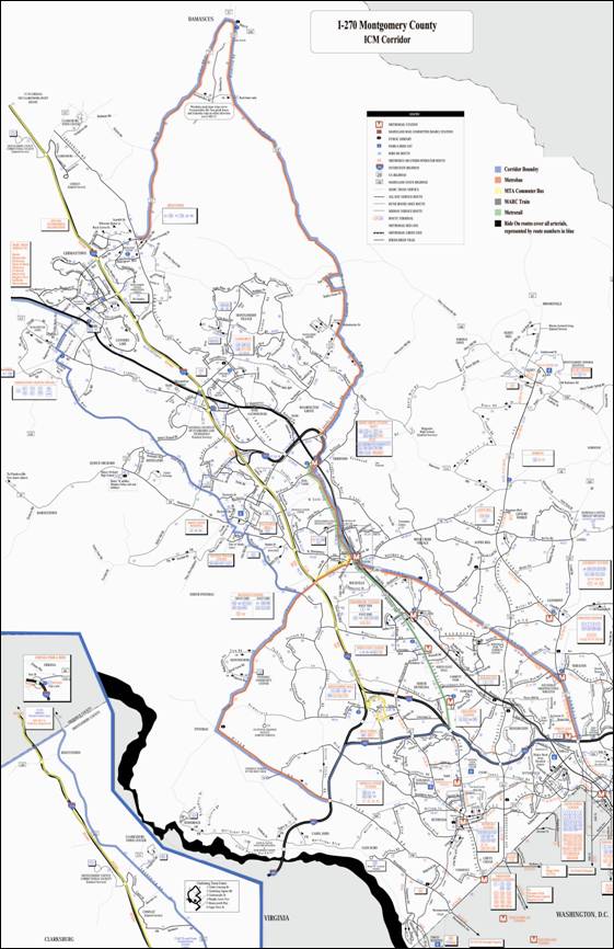
Click
here for large detailed image
Figure 3-2. I-270 ICM
Corridor Detector Locations
Image Source: DPWT
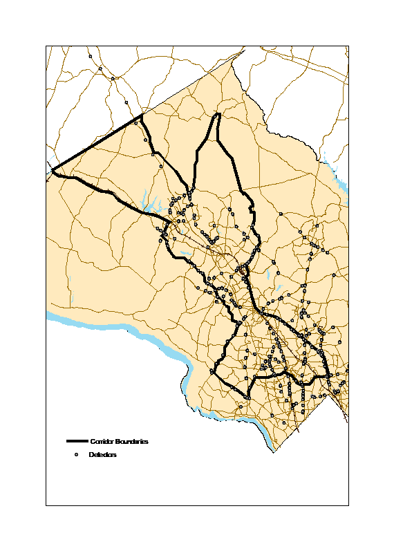
Figure 3-3. I-270 ICM Corridor HAR, DMS, CCTV, and
RWIS Locations
Image Source: DPWT
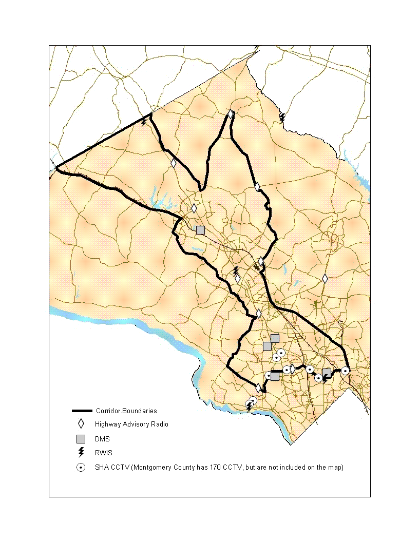
Table 3-1. I-270 Corridor Network Characteristics
|
Characteristics | |
|---|---|
|
Freeway Network |
|
|
Arterial Network |
|
|
MARC Commuter Rail Network |
|
|
Metrorail Network |
|
|
Metrobus Network |
|
|
Ride On Network |
|
|
MTA Commuter Bus |
|
3.2 Corridor Stakeholders
Key ICM stakeholders for the I-270 Corridor are identified in Table 3-2, below.
Table 3-2. I-270 Corridor Stakeholders
|
The following agencies are partnered in the development of the ICM initiative:
Stakeholders The following entities have potentially important stakes in the outcome of the ICM initiative and have advised and guided the process:
|
The following stakeholders are responsible for operating one or more networks within the I-270 Corridor:
-
Maryland State Highway Administration (MDSHA) Management of the freeway network.
-
Montgomery County Department of Public Works and Transportation (DPWT) Management of the countys arterial network, as well as Ride On bus service.
-
Maryland Transit Administration (MTA) Operation of MARC rail service and MTA Commuter Bus.
-
Washington Metropolitan Area Transit Authority (WMATA) Operation of Metrorail and Metrobus, and monitoring and managing parking facilities at stations.
-
Maryland State Police Enforcement, security, and crash investigations on freeways.
-
Montgomery County Police Enforcement, security, and crash investigations on Montgomery County arterials.
-
City of Rockville Management of the arterial network in Rockville.
-
City of Gaithersburg Management of the arterial network in Gaithersburg.
-
University of Marylands Center for Advanced Transportation Technology (CATT) Maintenance and operation of the Regional Integrated Transportation Information System (RITIS) prototype.
3.3 Operational Conditions of the I-270 Corridor and Included Networks
3.3.1 The Freeway Network
The I-270/Montgomery County Corridor contains a single interstate highway, I-270. Originally built in the early 1950s as a four-lane roadway called the Washington National Pike (US-240), the travel route now designated as I-270 has been widened and substantially improved over the years.
Table 3-3, below, identifies average annual daily traffic (AADT) counts and level of service (LOS) for key segments of I-270.
Table 3-3. Average Annual Daily Traffic and Level of Service on I-270
|
Section of I-270 (from South to North) |
2005 AADT |
LOS AM Peak Direction |
LOS PM Peak Direction |
|---|---|---|---|
|
South of MD-187 (East Y Split) |
127,000 |
F |
F |
|
North of MD-187B (West Y Split) |
126,000 |
F |
F |
|
North of Tuckerman Lane |
256,000 |
F |
F |
|
North of Montrose Road |
261,000 |
F |
E |
|
North of Falls Road |
264,000 |
F |
E |
|
North of MD-28 |
241,000 |
F |
E |
|
North of Shady Grove Road |
219,000 |
F |
F |
|
North of I-370 |
208,000 |
F |
F |
|
South of MD-124 |
172,000 |
F |
F |
|
South of Middlebrook Road |
164,000 |
D |
F |
|
South of MD-118 |
130,000 |
C |
D |
|
South of Father Hurley Blvd. |
117,000 |
D |
C |
|
South of MD- 121 |
98,000 |
C |
E |
|
South of MD-121 (ATR0004) |
97,000 |
C |
E |
|
North of MD-121 |
94,000 |
E |
E |
|
South of Frederick County Line |
87,000 |
E |
E |
3.3.2 The Arterial and Connector Route Network
The I-270/Montgomery County Corridor has a limited number of north-south arterials paralleling the freeway. The only truly viable alternative is MD-355. Other routes providing north-south access in the vicinity include: MD-85 to MD-28 and MD 112/MD-190. These routes, however, do not provide nearly the capacity of, or ease of connection to, I-270 that MD-355 does.
In the southern portion of the corridor, MD-355 is a multi-lane signalized arterial. From Gaithersburg north, it is primarily a two-lane rural highway. MD-355 is characterized as follows:
-
Frederick County Line to North of Brink Road Approximately 6 miles; Rural Major Collector.
-
North Brink Road to MD-118 Approximately 1 mile; Rural Minor Arterial.
-
MD-188 to the Washington Capital Beltway Approximately 15 miles; Urban Principal Arterial.
Within the I-270 Corridor, traffic varies on MD-355 based on the volume of traffic at signalized intersections, I-370, and the Capital Beltway. Traffic also varies due to trip origin and destination points including commercial districts, sources of employment, and residential areas. Table 3-4, below, provides annual average daily traffic (AADT) counts for MD-355.
Table 3-4. MD-355 Average Annual Daily Traffic
|
MD-355 Segments (from South to North) |
2005 AADT |
|---|---|
|
North of I-495 Interchange |
55,000 |
|
Between I-495 and Old Georgetown Road |
54,000 |
|
Between Montrose Rd. and Great Falls Road |
57,000 |
|
Between West Montgomery Avenue and Gude Drive |
49,000 |
|
Between Gude Drive and Shady Grove Road |
48,000 |
|
South of MD-124 |
36,000 |
|
Between MD-124 and MD 118 |
33,000 |
|
South of MD-118 |
29,000 |
|
Between MD-118 and MD-27 |
37,000 |
|
Between MD-27 and MD-121 |
13,000 |
|
Between MD-121 and MD-109 |
11,000 |
|
North of MD-109 |
9,000 |
Twelve connector routes link I-270 to MD-355. These routes provide varying levels of service from I-270 to MD-355. The routes also have different numbers of access lanes and very different volumes of traffic. Table 3-5, below, characterizes these routes.
Table 3-5. Connector Route Annual Average Daily Traffic
|
Arterial Connection |
I-270 Exit # |
Lanes of Access |
2005 AADT |
|---|---|---|---|
|
MD-109/Old Hundred Road |
22 |
2 |
9,000 |
|
MD-121/Clarksburg Road |
18 |
2 |
14,000 |
|
MD-27/Father Hurley Blvd/Ridge Road |
16 |
4 |
25,000 |
|
MD-118/Germantown Road |
15 |
4 |
29,000 |
|
Middlebrook Road |
13 |
4 |
31,000 |
|
MD-124/Quince Orchard Road/ Montgomery Village Avenue |
11 |
4 and 2 |
81,000 |
|
MD-117/West Diamond Avenue |
10 |
2 |
44,000 |
|
I-370 |
9 |
6 |
76,000 |
|
Shady Grove Road |
8 |
4 |
40,000 |
|
West Montgomery Avenue |
6 |
4 and 3 |
25,000 |
|
Great Falls Road |
5 |
4 and 2 |
29,000 |
|
Montrose Road |
4 |
4 |
63,450 |
|
MD-187/Old Georgetown Road |
1 |
4 |
45,000 |
3.3.3 The MARC Commuter Rail Network
The Maryland Transit Administration (MTA) provides commuter rail service along the I-270 Corridor. The Maryland Rail Commuter (MARC) Train offers service from Martinsburg, West Virginia into downtown Washington D.C. along the MARC Brunswick Line. The stations and passenger service along the corridor are oriented predominantly towards commuters working in downtown Washington, D.C., as well as commuters who work in Rockville, Silver Spring, and other Montgomery County locations.
The MARC Brunswick Line serves approximately 2,524 riders during the AM peak and a total of 5,047 riders daily. Rail cars on the MARC trains are generally filled to capacity and demand is high for added service a need not easily filled since the MARC trains share the track with CSX freight trains. Transfers are available from MARC to Metrorail at the Rockville and Silver Spring stations.
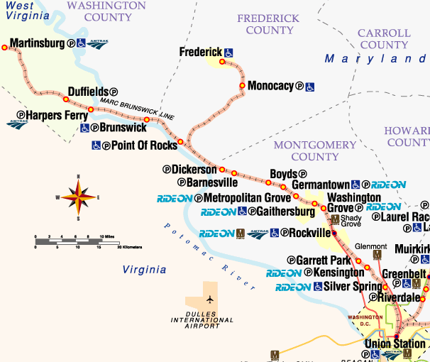
Figure 3-4 shows the route covered by the MARC Brunswick Line. The stations serviced by the Brunswick Line that lie within the I-270 ICM, from NW to SE, are:
-
Dickerson
-
Barnesville
-
Boyds
-
Germantown
-
Metropolitan Grove
-
Gaithersburg
-
Washington Grove
-
Rockville
-
Garrett Park (just outside I-270 ICM corridor)
Figure 3-4. Map of the MARC
Brunswick Line
Image Source: Maryland Transit Administration
3.3.4 The Metrorail Network
WMATAs Metrorail network serves the entire Washington, D.C. region. The network consists of five Metro lines, as depicted in Figure 3-5, below.
Figure 3-5: The Metrorail
Network
Image Source: Washington Metropolitan Area Transit Authority
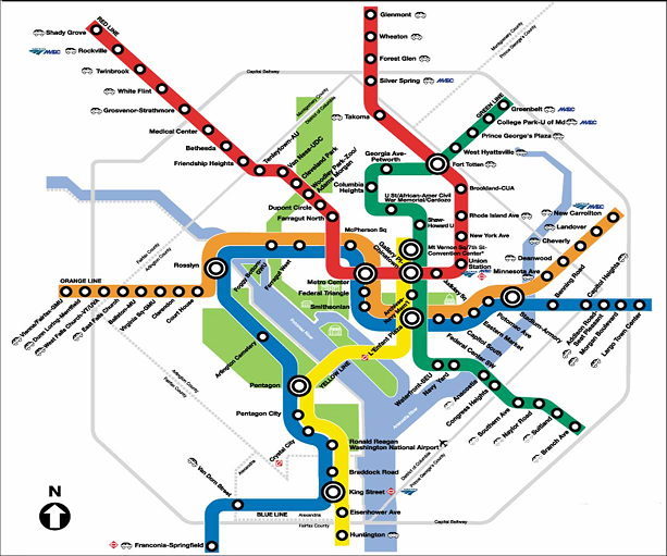
The Red Line serves commuters in the I-270 Corridor; it runs along MD-355 from Shady Grove to the Capital Beltway and into downtown Washington. Metrorail stations within the corridor include Shady Grove, Rockville, Twinbrook, White Flint, and Grosvenor-Strathmore.
The Red Line is WMATAs busiest line and the only one that does not share its track with another line. Because it is the only subway line serving the area, WMATA runs two routes along the Red Line during the morning and afternoon peaks. One route runs all the way to Shady Grove; the other turns around at the Grosvenor-Strathmore Station to accommodate the higher volumes of riders closer to the city. All Metrorail stations support transfers to Metrobus and Ride On. The Rockville station also serves as a MARC station.
Metrorail travel patterns are consistent with the rest of the corridor. Morning peak travel moves predominantly in the direction of downtown Washington, D.C., whereas the afternoon peak moves from Washington towards the Maryland suburbs. Average weekday ridership for the morning and afternoon peak hours on the Red Line is summarized in Table 3-6.
Table 3-6. Average Metrorail Weekday Ridership in the I-270 Corridor
|
Station Name |
Entry/Exit |
Average Weekday | ||||
|---|---|---|---|---|---|---|
|
|
|
AM Peak |
AM Off |
PM Peak |
PM Off |
Total |
|
Grosvenor |
Entry |
3,464 |
891 |
796 |
275 |
5,428 |
|
|
Exit |
336 |
549 |
2,827 |
1,359 |
5,072 |
|
White Flint |
Entry |
1,227 |
713 |
1,396 |
344 |
3,682 |
|
|
Exit |
1,253 |
598 |
1,246 |
579 |
3,678 |
|
Twinbrook |
Entry |
2,332 |
853 |
1,070 |
275 |
4,531 |
|
|
Exit |
827 |
621 |
1,990 |
1,029 |
4,468 |
|
Rockville |
Entry |
2,288 |
809 |
894 |
245 |
4,237 |
|
|
Exit |
745 |
646 |
2,110 |
760 |
4,262 |
|
Shady Grove |
Entry |
9,570 |
1,874 |
1,514 |
402 |
13,360 |
|
|
Exit |
936 |
1,321 |
8,027 |
2,896 |
13,181 |
3.3.5 The Metrobus Network
Metrobus is WMATAs regional bus transit network serving the Metropolitan Washington, D.C. area. Within the I-270 Corridor, Metrobus has four routes that directly service commuters inside the corridor. These routes are:
-
J5 The J5 route follows MD-355 from the Twinbrook Metrorail Station to the Capital Beltway.
-
J8/J9 These express routes run on I-270 from the Lakeforest Transit Center to the Capital Beltway.
-
T2 The T2 route runs from the Rockville Metrorail Station to the Friendship Heights Metrorail Station, following Great Falls Road (MD-189) to River Road (MD-190).
-
Q2 The Q2 route follows MD-355 from the Shady Grove Metrorail Station to the Rockville Metrorail Station.
All four Metrobus routes provide opportunities for transfers to Metrorail and Ride On. Additionally, the Q2 and T2 link to MARC at the Rockville Metrorail Station. Average weekday passengers per trip for each route are provided in Table 3-7, below.
Table 3-7. Metrobus Average Weekday Boardings per Trip
|
Metrobus Route |
3:00am to 5:30am |
5:30am to 9:30am |
9:30am to 3:00pm |
3:00pm to 7:00pm |
7:00pm to 3:00am |
|---|---|---|---|---|---|
|
J5 |
N/A |
17.55 |
N/A |
12.25 |
N/A |
|
J8/J9 |
N/A |
18.88 |
23.50 |
17.97 |
N/A |
|
T2 |
N/A |
31.67 |
22.48 |
26.63 |
14.29 |
|
Q2 |
27.13 |
61.94 |
70.26 |
78.98 |
52.64 |
3.3.6 The MTA Commuter Bus Network
The MTA Commuter Bus provides long distance service during peak periods parallel to MARC rail lines. Route 991 begins north of Montgomery County and travels south on I-270 during the AM rush. Buses stop at the Rockville Metro station, and again at the Rock Spring Business Park, near I-495. Buses operate only in the peak direction at 15 minute headways. Average daily ridership in April 2007 was 975 passengers. Most buses are operating at capacity, and because there is a no standing rule in effect, its difficult to accurately measure demand.
3.3.7 The Ride On Network
Ride On is Montgomery Countys local bus service that provides concentrated service within the I-270 Corridor. Bus service emphasizes connections to Metrorail, Metrobus, and MARC. Bus service is also available at key Park-n-Ride lots, including the following:
-
Comus Park-n-Ride Ride On Route 75 (with service to Shady Grove Metrorail Station); located off MD-121, east of I-270.
-
Milestone Park-n-Ride Ride On Routes 55, 70, 75 (all three with service to Shady Grove Metrorail Station), 79 (service to Shady Grove Metrorail Station), 83 (with service to Germantown MARC Station), and 90; located off MD-27, east of I-270.
-
Germantown Transit Center Ride On Routes 68 and 71 (to Shady Grove Metrorail Station); includes MARC service connection; located off MD-118, west of I-270.
-
Lake Forest Transit Center Ride On Routes 54, 56, 59 (all three with service to Rockville Metro Station), 55, 57 (both with service to Shady Grove and Rockville Metrorail Stations), 56, 58, and 62 (all three with service to Shady Grove Metrorail Station); located off MD-124, east of I-270.
-
Clopper Road Park-n-Ride Ride On Route 124 (including express shuttle service to Shady Grove Metrorail Station); located at MD-117 and I-270 Interchange.
-
Gaithersburg Park-n-Ride Ride On Route 124 (including express shuttle service to Shady Grove Metrorail Station); located at MD-124 and I-270 Interchange.
-
Montrose Road/MD-355 Park-n-Ride Ride On Routes 5 (serving Twinbrook, White Flint, and Silver Spring Metrorail Stations), 38 (serving White Flint and Wheaton Metrorail Stations), and 46 (serving Shady Grove, Rockville, Twinbrook, White Flint, and Grosvenor Metrorail Stations); located off Montrose Road, east of I-270.
-
Westfield Shoppingtown Park-n-Ride Ride On Routes 26 (serving Twinbrook Metrorail Station), 35, 38, 47 (serving Rockville and Grosvenor-Strathmore Metrorail Stations), and 96 (serving Grosvenor-Strathmore Metrorail Station); located off Old Democracy Blvd., west of I-270 Spur.
Table 3-8, below, shows average weekday ridership for key Ride On bus routes:
Table 3-8. Average Weekday Ridership on Selected Ride On Routes
|
Route |
Origin |
Destination |
Weekday Ridership |
|---|---|---|---|
|
54 |
Lakeforest |
Rockville Metro Station |
2,038 |
|
55 |
Germantown Transit Center |
Rockville Metro Station |
6,900 |
|
56 |
Lakeforest |
Rockville Metro Station |
2,364 |
|
59 |
Montgomery Village Center |
Rockville Metro Station |
3,910 |
|
70 |
Milestone Park and Ride |
Bethesda Metro Station |
547 |
|
71 |
Kingsview Park and Ride |
Shady Grove Station |
306 |
|
75 |
Urbana Park and Ride |
Shady Grove Station |
229 |
|
79 |
Milestone Park and Ride |
Shady Grove Station |
129 |
|
83 |
Milestone Park and Ride |
Germantown Transit Center |
697 |
|
90 |
Damascus |
Shady Grove Station |
860 |
|
124 |
MD-124 Park and Ride |
Shady Grove Station |
71 |
3.4 Existing Network-Based Transportation Management/ITS Assets
The I-270/Montgomery County Corridor consists of a variety of networks operated by different stakeholders. Table 3-9, below, identifies the available ITS infrastructure and assets held by these transportation networks.
Table 3-9. Network-Based Transportation Management/ITS Assets
|
Network |
Stakeholder |
Stakeholder Facilities |
ITS Infrastructure/ Assets |
|---|---|---|---|
|
Freeway Network |
Maryland State Highway Administration (MDSHA) |
|
|
|
Arterial Network |
Montgomery County Department of Public Works and Transportation (DPWT) |
|
|
|
MARC Commuter Rail Network |
Maryland Transit Administration (MTA) |
|
|
|
Metrorail Network |
Washington Metropolitan Area Transit Authority (WMATA) |
|
|
|
Metrobus Network |
Washington Metropolitan Area Transit Authority (WMATA) |
|
|
|
Ride On Network |
Montgomery County Department of Public Works and Transportation (DPWT) |
|
|
3.5 Proposed Near-Term Network Improvements
Near-term network improvements proposed for the I-270 ICM Corridor are summarized below. The improvements are categorized by network type and responsible agency; anticipated timetables and completion dates are also shown, where appropriate:
Freeway Maryland State Highway Administration (MDSHA)
-
Upgrade of the Coordinated Highway Action Response Team (CHART) System Software:
-
Upgrade the video system to support IP-based video, which will allow CCTV video and data from CHART cameras to be distributed via the MDOT T1 Ethernet network to all facilities/centers/agencies connected to the CHART network. The project will completed mid-2009.
-
MDSHA is selecting a contractor to develop a new iteration of the CHART platform, which will provide for additional capabilities, including:
-
A Center-to-Center Module.
-
Integration with Smart Parking Systems Providing information to truck stop and rest areas.
-
Cell Phone Probe Data Integrating cell phone tracking data for speed and travel time information.
-
Enhanced Data Dissemination Sharing information with the public through notification services (fax, pager, email, Web-based Real Simple Syndication (RSS), WAP/PDA access, etc.).
-
Diversion Route Management Providing alternative routing and loadings during incident management.
-
Signal Control Incorporating arterial signal information and command and control support.
-
-
The Emergency Operations Reporting System (EORS) is MDSHAs system for collecting and distributing maintenance, construction, and adverse weather operations information across the state. The system is being migrated to a Web-based platform to make it easily accessible to all maintenance shops and other facilities on the MDOT network. The system should be fully operational by early 2009.
-
-
Update of the SHA Freeway Incident Traffic Management (FITM) Plans for the I-270 Corridor:
-
MDSHA has documented operational plans for all closures along major interstate corridors within Maryland primarily within the Washington D.C. and Baltimore Regions. They include route diversion maps and a traffic management measure for closures at specified segments along the interstates. As such, they typically include routing traffic onto arterial routes and back to the interstate at the next exit.
-
FITM plans along I-270 are being updated with input from Montgomery County DPWT and Maryland State Police. The purpose of this update is to improve the management of heavy backups and delays during major closures on interstates.
-
Montgomery Countys traffic operations team will take account of traffic signal system capabilities and current travel patterns in order to efficiently route traffic around incidents.
-
Eventually, the FITM plans will be based on automated signal timing plans so they can be easily activated upon request by MDSHA CHART and/or Maryland State Police.
-
FITM plans in the I-270 ICM Corridor should be complete by late-2009.
-
-
Increase in Number of Closed-Circuit Television (CCTV) cameras, with an adequate number installed by 2010.
-
Increase in Number of Highway Advisory Radio (HAR) stations, with an adequate number installed by 2010.
-
Increase in Number of Dynamic Message Signs (DMS), with an adequate number installed by 2010.
-
Increase in Number of Freeway Sensors, with an adequate number installed by 2010:
-
SHA has detectors on the I-270 corridor used to feed into CHART.
-
MDSHA also has an agreement with Mobility Technologies to deploy additional detectors on the I-270 corridor. Data from these detectors are to be fed to CHART for incident detection purposes; however, the agreement prohibits MDSHA from independently disseminating these data, but instead relies on Mobility Technologies to distribute the data via the Traffic.com Web page or other Traffic.com data dissemination outlets.
-
Once in place, data from Mobility Technologies detectors could become a key element for deploying real-time traffic modeling systems (e.g., as part of current work by MDSHA with the University of Maryland), as well as providing more comprehensive traffic flow information through the Traffic.com web site.
-
-
The Intercounty Connector (ICC) linking I-370 and I-95:
-
MDSHA has won approval to proceed with the design and deployment of this four-lane highway connecting I-370 (which, in turn, connects to I-270) with I-95.
-
This roadway is expected to be a toll-road that provides commuters traveling to the Capital Beltway with an alternative route (around I-270) for reaching the Beltway.
-
The ICC is currently scheduled for completion by 2012.
-
Because decisions to proceed with the ICC project are being made independently of the ICM efforts, and involve state- and county-wide policies and actions, the I-270 ICM plan is not predicated on the funding or existence of the ICC.
-
-
Operational Use of the I-270 Simulator for Incident Management purposes on I-270.
-
Design and Deployment of the Regional Integrated Transportation Information System (RITIS)
-
The University of Marylands CATT Laboratory has taken the lead in developing RITIS. A prototype is operational in the Metropolitan Washington Region, with deployment expanding rapidly in 2008.
-
RITIS will collect data of regional interest and fuse the data into regional information that can be used to enhance regional traveler information and transportation management functions performed by member agencies.
-
This system is intended to improve transportation efficiency, safety, and security through the integration of existing transportation, emergency management, and transit systems.
-
Potential benefits include accelerating and broadening the exchange of regional transportation management information between participating agencies in the corridor.
-
RITIS is intended to enhance communications and the coordination of actions and resources when responding to regional incidents, special events, and extreme congestion.
-
Arterials Montgomery County DOT
-
Update of the Traffic Signal System:
-
Montgomery County DPWT is in the process of updating the traffic signal system to include an actuated traffic signal strategy. The project will commence in the summer of 2008 with expedited deployment at the intersections within the I-270 ICM corridor. Note that the capability to download timing plans in response to events taking place on I-270 already exists within the current traffic signal control system. Timing plans for these type of events are either existing or will be developed as a backup plan. The project is expected to finish between 2009 and 2013. Priority will be given to signals in the corridor.
-
Increase in signalized intersections on an as-needed basis (the current system has a capacity of 1,500 intersections; 700 are presently on-line).
-
-
Increase in Closed Circuit Television (CCTV) cameras:
-
Plans are underway to procure and deploy additional cameras annually, as budgets permit. Expected rate is 20 cameras per year, with an estimated completion date of 2010.
-
-
Development of a connection to the MDOT network via Montgomery County's Fibernet and the SHA connection to the MIEMSS (Maryland Institute for Emergency Medical Services Systems) network, to be completed in 2007.
-
Installation of CapWIN mobile data terminals in the Service Patrol vehicles. Expected completion date of 2008.
Railway/Metro
Maryland Transit Administrations (MTA) Maryland Regional Commuter (MARC) Train:
-
Consolidation of communications of equipment along the Brunswick Line in order to communicate data from devices at the stations over the MDOT T1 Ethernet backbone, which substantially parallels the rail. This is to be completed by late 2008.
-
MARC GPS train location and schedule adherence tracking and alert system (separate from CSX rail line tracking system). This is currently underway, and is projected to be fully operational by 2008.
-
Improved fare collection system, including payment using SmarTrip cards. The project is projected to be completed in late 2008.
Washington Metropolitan Area Transit Authority (WMATA):
For the purpose of this listing of near-term improvements, the two types of transportation modes operated by WMATA (Metrorail and Metrobus) are combined here because these improvements affect both modes.
-
Regional Smart Card Concept:
-
The Metropolitan Washington, D.C. area is in the process of expanding WMATAs existing SmarTrip smart card system to include local bus (i.e., Ride On) and commuter rail services (i.e., MARC). No target date has been established, but work will likely begin in 2007 and finish in 2009.
-
-
WMATA Bus Operations Control Center (BOCC):
-
WMATA is currently establishing a new BOCC in Landover, Maryland. This facility will be furnished with twelve (12) control center consoles with radio control, computer, display, input, and associated audio equipment. The BOCC will become operational in December 2008.
-
Once the Landover BOCC becomes operational, WMATA intends for the current BOCC in downtown Washington D.C to serve as an emergency dispatch center to be used when the new facility is not accessible.
-
-
Transit Traveler Information:
-
The existing Ride Guide system is WMATAs core application that allows commuters to generate trip planning itineraries using the Web, instead of calling WMATA's traditional in-bound customer service representatives.
-
WMATA partners with the major regional and local transit providers within the D.C. area to provide commuters with a single integrated system that can generate a consolidated trip itinerary across the region, even when the trip involves multiple service providers.
-
All commuters using either WMATA and/or its transit partners facilities will benefit directly from the anticipated improvements made to the trip planning system.
-
-
Advanced Parking System:
-
WMATA is testing an advanced parking system at the Glenmont Metro Station, which will potentially serve as a prototype for other Metro parking lots. Project to be completed by 2009.
-
-
CAD/AVL System:
-
Integration of the automatic vehicle location (AVL) system with route schedules so that route schedule adherence can be determined in real-time. This information will be sent from Metrobus vehicles to operators at the BOCC via the Mobile Data Terminals (MDTs). Project to be completed in February 2008.
-
Integration of APC, AVM, and Cubic fare boxes with MDTs. This information will be sent to the BOCC through the MDTs. Project to be completed in February 2008.
-
Upgrade of CAD/AVL hardware/software. Project to be completed in February 2008.
-
Development of a transit database that will become the central communications path and data interface for future Metrobus systems. Project to be completed in February 2008.
-
Bus Service Ride On:
Representative enhancements planned or underway are summarized below:
-
The Transit Office plans to deploy software that allows the rescheduling of routes based on system data. Project to be completed in Fall 2007.
-
Real-time data sharing with WMATA. Project to be completed in January 2009.
-
Integration of Ride On data with emergency operations and homeland security. This task will be accomplished through RITIS implementation, expected in 2008.
-
Deployment of mobile data terminals in the vehicles of on-street supervisors to allow supervisors to monitor and track buses while in their cars for rescue and dispatch. Project to be completed in August 2007.
-
Improved fare collection system, including Washington Regional SmarTrip payment. This card will work in conjunction with smart fare boxes to track passenger counts and fares. Project to be completed in April 2007.
-
Acquisition of more security cameras for installation in buses. This project is ongoing, with adequate infrastructure to support the ICM implementation expected to be in place by 2008.
-
Upgrades to Orbital Corporations AVL system to include:
-
Bus stop annunciators.
-
Passenger counts with real-time communications to the central system.
-
A single sign-on for drivers to automatically program their route into destination signs.
-
Improved system reports.
-
Improved communications using Wi-Fi data uploads and downloads to the buses while they sit in the yard at night.
-
Project to be completed in July 2009.
-
-
Montgomery County (Ride On) Bus PriorityMontgomery County has deployed a pilot program for signal priority to Ride-On buses using the existing on-board Automated Vehicle Location (AVL) systems and upgrades to the Montgomery County traffic signal system. Montgomery County has deployed a pilot program for signal priority to Ride-On buses using the existing on-board Automated Vehicle Location (AVL) systems and upgrades to the Montgomery County traffic signal system. While the upgrade of the AVL system is a separate project from the upgrade of the signal system, the AVL system upgrade is expected to be done by the summer of 2008, at the time the traffic signal control system upgrade will start. Aside from the pilot project, the first intersections to be equipped with signal priority will be along the MD-355 corridor. Full signal priority to be completed between 2009 and 2013, with priority implementations given to those along the I-270 ICM corridor.
3.6 Current Network-Based Institutional Characteristics
The partner agencies involved in the Montgomery County I-270 Integrated Corridor Management initiative are represented on the National Capital Region Transportation Planning Board (NCR/TPB), which is the federally-designated metropolitan planning organization (MPO) for the region. Over the last 15 years, considerable progress has been made in establishing an institutional framework conducive to ITS and operations within the NCR/TPB structure. In addition, there have been a number of ongoing regional operations coordination initiatives, including the Regional Operations Coordination Committee (ROCC) that, since the late 90s, has been working to improve ITS operations planning and coordination. Most recently, transportation agencies in the region have gotten together to strengthen regional coordination and communications on everyday conditions, management, and major regional transportation incidents through creation of the Metropolitan Area Transportation Operations Coordination (MATOC) Program.
It is clear that the current institutional environment in the region lends itself to supporting the I-270 ICM in the near-term and, more importantly, over the long-term as ICM activities become mainstreamed as part of ongoing regional operations initiatives.
Transportation Planning Board and the Subcommittee on Management, Operations, and Intelligent Transportation Systems
The TPB is housed under the Metropolitan Washington Council of Governments (COG). COG is composed of 21 local governments surrounding the nations capital, plus area members of the Maryland and Virginia legislatures, the U.S. Senate, and the U.S. House of Representatives. COG provides a focus for action and develops sound regional responses to issues such as the environment, housing, economic development, health and family concerns, human services, population growth, public safety, and transportation. The TPB, as the federally designated MPO for the region, prepares transportation plans and programs that the federal government must approve in order for federal-aid transportation funds to be spent in the Washington, D.C. region. Members of the TPB include representatives of local governments; state transportation agencies; the Maryland and Virginia General Assemblies; the Washington Metropolitan Area Transit Authority; and non-voting members of the Metropolitan Washington Airports Authority (MWAA) and federal agencies.
Within the TPB committee structure, a Coordination Planning Subcommittee on Management, Operations, and Intelligent Transportation Systems (MOITS) is responsible for ensuring that the key elements of management, operations, and ITS are reflected in the metropolitan transportation planning process. The Safe, Accountable, Flexible, Efficient Transportation Equity Act: A Legacy for Users (SAFETEA-LU) requires statewide and regional transportation plans to consider operational and management strategies to improve the performance of existing transportation facilities to relieve vehicular congestion and maximize the safety and mobility of people and goods. Major topics that are relevant to the I-270 ICM institutional infrastructure that will be advanced by the TPB through MOITS within the FY 2008 Unified Planning Work Program (UPWP) for Transportation Planning include:
-
Metropolitan Area Transportation Operations Coordination (MATOC) Program and Related Activities: Coordinate with member transportation agency efforts to strengthen regional coordination and communications on everyday conditions, management, and major regional transportation incidents, particularly through the MATOC Program (described in further detail below).
-
Traveler Information: Coordinate enhancement of the collection, processing, and public delivery of real-time roadway and transit condition information, including potential regional Internet-based and 511 information systems and the Regional Integrated Transportation Information System (RITIS) initiative.
-
ITS Architecture and Transportation Technology Development and Application: Maintain the regional ITS architecture in accordance with federal regulations and facilitate the use of the regional architecture as guidance for regional MOITS project implementations.
-
Traffic and Transit: Coordinate with regional transit committees on planning and information exchange for traffic management, bus operations, and advanced technology.
-
Traffic Signals: Work with member agencies to exchange information and coordinate inter-jurisdictional traffic signal operations.
-
Emergency Coordination: Facilitate coordination between everyday operations planning and overall regional planning for emergencies.
With regard to the last topic, a significant Transportation Emergency/Security Planning program has been established outside of the TPBs UPWP funded through U.S. Department of Homeland Security and COG local funding. The specialized needs for transportation involvement in Homeland Security directed preparedness are being addressed by the Regional Emergency Support Function #1 (RESF-1) Transportation Committee in the COG public safety committee structure with coordination and support from the MOITS subcommittee of TPB.
Another significant TPB coordination planning responsibility that relates to the I-270 ICM initiative is the Congestion Management Process (CMP). The regional CMP is a required component of the regional transportation planning process and is intended to address the systematic management of traffic congestion and provision of information on transportation system management of traffic congestion and provision of information on transportation system performance. Components of a CMP include a system for data collection and performance monitoring, strategies for addressing congestion, performance measures, or criteria for identifying when action is needed, and a system for prioritizing which congestion management strategies would be most effective. Under the FY08 UPWP, the TPB will undertake an analysis for development of CMP components of the Constrained Long-Range Plan working in coordination with the Travel Forecasting Subcommittee, Commuter Connections Subcommittee, MOITS Subcommittee, Technical Committee, and the Regional Travel Trends Report and Regional Transportation Data Clearinghouse efforts.
Metropolitan Area Transportation Operations Coordination (MATOC) Program
In late 2006, the states of Maryland and Virginia, and the District of Columbia demonstrated their commitment to coordinate and support regional sharing of transportation systems conditions and information management during regional incidents by formally executing an agreement for the establishment and maintenance of the Metropolitan Area Transportation Coordination Program. This commitment to coordinate will be manifested through integration of systems technologies, improved procedures and planning, and enhanced accuracy and timeliness of transportation information provided to the public. The MATOC Program is led by a Steering Committee currently comprised of representatives from the District Department of Transportation, Maryland Department of Transportation, Virginia Department of Transportation, and the Washington Metropolitan Area Transit Authority, with COG as the administrative agent. Development and implementation of the MATOC Program is reflected in the Transportation Improvement Program (TIP) of the TPB.
Currently, the MATOC Steering Committee is working on a contract for the services of a Program Implementation Manager (PIM) and technical support team to initiate formal implementation of the program. The PIM will be focusing on the identification of needs and opportunities for systems integration and enhancements and managing the process by which Steering Committee agencies agree to implement actions needed for systems integration. With regard to regional incidents, the PIM will examine ongoing operations and available operating procedures to identify needs and opportunities for interagency standard operating procedures and managing the process by which the Steering Committee agencies implement actions needed to enhance regional operations coordination processes.
MATOC is the oversight body for important regional initiatives such as the Regional Integrated Transportation Information System (RITIS), which will be leveraged extensively by the I-270 ICM project. RITIS is a data fusion and dissemination system that will compile transportation data from each participating agency, standardize it, and make it available to other participating agencies through each agencys existing transportation management system. RITIS will facilitate communications and coordination during incident response and management. It will also archive data for use in transportation-related studies and performance evaluations. In addition to the I-270 ICM partners, current agency participants include DDOT and VDOT.
Regional Operations Coordination Committee
In 1997, a committee called the Regional Operations Coordination Committee (ROCC) was formed to develop a framework for all participating agencies to conduct coordinated transportation management at the regional level. The ROCCs geographic focus is the Maryland National Capital Region and it includes representatives from transportation (traffic and transit) and public safety agencies in the State of Maryland, Montgomery County, and Prince Georges County.
Today, the ROCC continues to meet on a regular basis and has served as the catalyst for accomplishing numerous achievements since its inception. Highlights of these achievements include:
-
One of the first activities undertaken by ROCC was the development of a Regional Architecture consistent with the National ITS Architecture. This was done years before Regional ITS Architectures became a federal requirement.
-
ROCC played a key role in advancing the construction of a Transportation Management Center (TMC) in Prince Georges County, Maryland. The Transportation Response Information Partnership (TRIP) Center has been in operation for a number of years and, because of ROCC, was integrated with the Maryland State Highway Administration and Montgomery County TMC after it became operational.
-
ROCC was instrumental in facilitating execution of a formal Management and Operations Coordination Agreement between the Maryland State Highway Administration and Montgomery County Department of Public Works and Transportation. The agreement documents the mutual goal of enhancing transportation management and operations functions by sharing information, coordinating activities, and pooling resources while retaining each agencys autonomy.
-
ROCCs early emphasis on tackling interagency and interdisciplinary operational communications served as the catalyst for the Capital Wireless Information Net (CapWIN) Program. CapWIN has developed a software client for field responders that allows for mobile data communications between public transportation and public safety agencies. This highly successful initiative now has its own Board of Directors and boasts 1000+ monthly users across 50+ agencies representing transportation and public safety disciplines.
-
Since September 11, 2001, ROCC has served as the focal point in the development of transportation evacuation plans that expand well beyond the District borders into the State of Maryland.
-
The ROCC has sponsored development of a number of operational support tools such as: MOVE-IT forms (in English and Spanish) to help move vehicles involved in fender-benders from travel lanes; revised medical examiner forms that allow the gathering of required information quickly in the event of a fatality so that travel lanes can be opened sooner; incident resource documentation; and a handbook for service patrol operators that facilitates communication with Spanish-speaking travelers requiring motorist assistance.
3.7 Regional ITS Architecture Review
The I-270 Corridor is documented and depicted in the Maryland Statewide ITS Architecture, which virtually all the I-270 Corridor stakeholders participated in developing. The MD Architecture is available online at: http://www.rita.dot.gov/cgi-bin/ExitPage/good_bye.cgi?url=http://www.itsmd.org/. The corridor is also part of the Metropolitan Washington Regional ITS Architecture (MWRITSA), which diagrams macro-level, center-to-center communications among stakeholders in the National Capital Region. Because the MWRITSA relies heavily on input from the MD Architecture, this section concentrates on the Maryland Statewide ITS Architecture.
Planned functionality, as reflected in the MD Architecture, includes the following:
-
A regional incident and emergency management operations control center to coordinate with state and local TMCs during emergencies. Since the Architecture was published in 2005, this element, called CapCom, has been reduced in scope to an information-sharing and archiving tool call. The new, broader element that has replaced it is referred to as RITIS/MATOC. The Maryland Architecture is currently being updated to reflect these changes.
-
The ability of Montgomery County to control and manage traffic signal timing plans.
-
CAD/AVL systems for transit vehicles and their respective centers, and for that data to be received by travelers.
-
A complex parking information system, by which parking management centers can send parking data to TMCs and ISPs, with the option of implementing a parking reservations system.
-
An Archive Management Center that collects transit, traffic, and other data from all stakeholders in the corridor.
The Maryland ITS Architecture Advisory Panel maintains the MD Architecture and provides a conformity form online for users to submit projects for conformity assessment. The Conformity Form and instructions are available online at:
http://www.rita.dot.gov/cgi-bin/ExitPage/good_bye.cgi?url=http://www.itsmd.org/index.php?page_id=919.
Conformity Forms are reviewed and archived in support of project conformity to the Architecture and maintaining a repository of necessary Architecture updates. The MD Architecture is currently being updated, with the next version to be published in late 2007. Projects developed as part of the I-270 ICM effort will be submitted to the Maryland ITS Architecture Advisory Panel via the Conformity Form. The projects will then be evaluated for compliance with the Architecture; once designs are finalized, the Maryland Architecture will be updated to reflect those designs.
3.8 Corridor Issues and Needs
This section describes the principal issues and needs of the I-270/Montgomery County Corridor. These needs were identified during workshops and discussions involving key stakeholders. Needs were organized and examined by five operational areas, as follows:
-
Incident and emergency management,
-
Traffic signals,
-
Transit and commuter management.
-
Traveler information, and
-
Infrastructure.
The most important needs identified by stakeholders are summarized in Table 3-10, below.
Table 3-10. I-270 Corridor Critical Needs
|
Incident and Emergency Management |
|
Issue: Non-recurring congestion is a monumental impediment to mobility in the corridor. Needs:
|
|
Traffic Signals |
|
Issue: Traffic signals in the corridor are often not optimized for conditions. Needs:
|
|
Transit and Commuter Management |
|
Issue: Transit services in the corridor are often inconvenient for rush-hour commuters. Needs:
|
|
Traveler Information |
|
Issue: Travelers often do not have sufficient information about roadway, traffic, and transit conditions to make informed travel decisions. Needs:
|
|
Infrastructure |
|
Issue: Infrastructure limitations sometimes impair responsiveness to changing traffic and congestion conditions. Needs:
|
3.9 Potential for ICM in the I-270 Corridor
The I-270/Montgomery County Corridor consists of the following independent networks:
-
Interstate 270, operated by MDSHA.
-
MD-355 and other local arterials, operated by DPWT.
-
MARC Brunswick Commuter Rail, operated by MTA.
-
Metrorail Red Line, operated by WMATA.
-
Metrobus, MTA Commuter Bus, and Ride On, operated by WMATA, MTA, and Montgomery County, respectively.
The corridor is exceptionally directional, connecting most commuters with their work place locations in Washington D.C., Northern Virginia, or Montgomery County itself.
During non-rush hour periods, I-270 often has sufficient capacity. However, during rush hour, the commuter volume routinely exceeds capacity. This is due, in large part, to the fact that traffic cannot leave the corridor (southbound in the morning and northbound in the evening) due to capacity limitations on the Capital Beltway and bottlenecks (reduction of the number of lanes from 6 to ultimately 2) in Frederick County. Commuters entering the corridor from the north do not have many choices in terms of alternate routes. The main roadways are I-270 and MD-355, which run parallel to each other.
Alternatively, commuters can choose to use the MARC commuter train or the WMATA Metro Rail system. Because the MARC commuter train makes only a few stops in the corridor, commuters who do not work directly at those stations need to switch to either Metrorail or bus. The Metrorail system has multiple stops serving many commuters, but it only starts at Shady Grove, which is roughly halfway down the corridor. This means that commuters using Metrorail either drive or bus to the rail stations. Those who drive to the Metro stations must first park before accessing the rail system.
Nearly everyday, unplanned events, notably incidents within or outside the corridor, have profound impacts on transportation conditions in the corridor, frequently producing large-scale travel delays, secondary incidents, etc. Of course, this produces frustration and can impact the areas economic competitiveness, particularly when the congestion in the corridor is perceived as systemic.
The I-270 Corridor stakeholders have worked for many years to address these transportation challenges. These stakeholders have learned that through careful, structured coordination, adverse transportation conditions can often be most effectively and efficiently managed.
3.10 I-270 Corridor Vision
In the future, transportation operations within the I-270/Montgomery County Corridor function at peak efficiency by optimizing use of the capacities of the different transportation modes within the corridor. Key technology systems and decision-support tools within the corridor are interoperable and real-time information on road and traffic conditions is commonly exchanged among the corridors managing partners and stakeholders. Operational strategies within the corridor are routinely adjusted in response to changing corridor conditions. Strategic management of the corridor emphasizes multi-modalism and commuters have flexible access to real-time transit and parking lot information. Travelers are apprised of current road surface, traffic, and transit conditions pre-trip and en-route; this information is then used to make informed travel and routing decisions. Performance metrics are employed across the corridor to assess variations in efficiency and safety benchmarks, refine the existing approaches, and formulate and deploy follow-on operational strategies.
4. ICM SYSTEM OPERATIONAL CONCEPT
This section describes the ICM operational concept for the I-270/Montgomery County Corridor.
4.1 Corridor Goals and Objectives
To achieve the corridor-wide vision enunciated in Section 3.10, I-270 Corridor Vision, four ICM goals were identified, as follows:
-
Optimize mobility, reliability, and safety;
-
Strengthen corridor-level decision support;
-
Enhance reliable, real-time information to customers; and
-
Promote multi-modalism.
These goals emerged from an analysis of corridor needs as documented in Section 3.8, Corridor Issues and Needs. The issues and needs were prioritized according to such factors as (1) the level of improvement in transportation conditions that could potentially be realized if the need was addressed, (2) the speed at which the need could reasonably be addressed, and (3) the ease with which the need could be mitigated. Goals intended to address the priority needs were then identified.
Table 4-1, below, defines the four goals and specifies the objectives associated with each.
Table 4-1. I-270/Montgomery County Corridor Goals and Objectives for ICM
|
Objectives | |
|---|---|
|
Optimize Mobility, Reliability, and Safety: Achieve the highest practical levels of mobility through the corridor. Maximize mobility and minimize delays associated with incidents and other non-recurring conditions. Make the travel experience more predictable and reliable so that day-to-day fluctuations in travel times are less extreme. Optimized performance, with less volatility and reduced exposure to adverse conditions, will affirmatively impact safety. |
|
|
Strengthen Corridor-Level Decision Support: Upgrade the information-exchange infrastructure to more rapidly put comprehensive, fact-based information on incidents and roadway conditions into the hands of responders, traffic managers, and other stakeholders. Furnish tools to stakeholders to support adept decision-making that results in faster, more efficient response and clearance. |
|
|
Enhance the Dissemination of Reliable, Real-Time Information to Customers: The precepts here are two-fold: (1) travelers deserve to be informed about roadway/transit conditions and circumstances; and (2) as travelers are kept apprised of conditions, they will be able to make intelligent choices and thereby become active agents in optimizing mobility. |
|
|
Promote Multi-Modalism: Encourage reductions in the volume of vehicles traversing the corridor by making transit and carpooling more attractive to customers. Even for those travelers who are loathe to abandon single-occupant vehicle travel permanently, encourage ad hoc shifts to alternative modes when conditions warrant. |
|
Note the keen interrelationships among the four goals and their associated objectives. For instance, the second, third, and fourth goals, if successfully accomplished, will contribute positively to mobility (Goal 1). Similarly, expanded use of alternative travel modes, notably transit (Goal 4), will hinge, in large part, on the ability to communicate timely and reliable transit information to travelers.
Table 4-2, on the following pages, examines the relationships between the corridor needs, identified in Section 3.8, Corridor Issues and Needs, and the ICM goals identified above. The needs are organized by the five operations areas previously identified. Additionally, distinctions are drawn between primary and secondary corridor needs. Primary needs, those that are asterisked (*), are those needs expected to be addressed in this ICM effort. Secondary needs are also important, but are not planned for redress during the initial ICM activities.
Table 4-2. Relationship Between I-270 ICM Corridor Needs and Goals
|
Corridor Needs |
Optimize Mobility, Reliability, and Safety |
Strengthen Corridor-Level Decision Support |
Enhance Reliable, Real-Time Information to Customers |
Promote Multi-Modalism |
|---|---|---|---|---|
|
Incident and Emergency Management | ||||
|
Stakeholder agencies both highway and transit need clearly articulated roles, responsibilities, and procedures for coordinated management and response to incidents and conditions in the corridor.* |
|
|
|
|
|
Agencies need concrete plans for diverting traffic from freeways to arterials.* |
|
|
o |
|
|
Agencies need innovative, synergistic, and multi-modal approaches to managing incidents and congestion.* |
|
|
|
|
|
Agencies need to detect and verify incidents quickly and efficiently.* |
|
|
o |
|
|
Agencies need mechanisms and procedures for sharing information on incidents and conditions.* |
|
|
o |
|
|
Agencies need tools and procedures that optimize operational decision-making.* |
|
|
|
|
|
Agencies need metrics for measuring and assessing performance and conditions in the corridor, both on freeways and arterials.* |
|
o |
|
|
|
Traffic Signals | ||||
|
Traffic signals on arterials along the corridor need to be able to respond instantly to changing traffic conditions.* |
|
|
|
|
|
Traffic signals need to be able to respond to changing conditions both on the affected arterials and adjacent roadways, including I-270.* |
|
|
|
|
|
Before signal systems are modified, determination is needed regarding optimal signalized responses under alternative scenarios.* |
|
|
|
|
|
Traffic signal prioritization for emergency vehicles is desirable. |
|
|
|
|
|
Transit and Commuter Management | ||||
|
Commuters need reliable transit information and services.* |
|
|
|
|
|
Commuters need on-demand access to rail/bus schedules and rail/bus real-time status.* |
|
|
|
|
|
Commuters need on-demand access to information comparing travel times by automobile and transit in real-time.* |
o |
|
|
|
|
Commuters need to know where available parking spaces in commuter lots are located.* |
|
|
|
|
|
Commuters need easy and convenient access from commuter lots to Metrorail and MARC stations.* |
|
|
|
|
|
An infrastructure that encourages unplanned automobile commuter shifts to transit, when conditions warrant, is desirable.* |
|
|
|
|
|
Commuters desire broader, more integrated usage of smartcards in the corridor.* |
|
|
|
|
|
Use of HOV lanes needs to be made easier and more convenient. |
|
|
o |
|
|
Traveler Information | ||||
|
Travelers need access to accurate, reliable, and multi-modal travel information, both pre-trip and en-route.* |
|
|
|
|
|
Travelers need travel conditions information in sufficient detail that they can make smart decisions about staying the course, selecting alternate routes, shifting travel modes, skipping or postponing travel, etc.* |
o |
|
|
o |
|
Travelers need information about alternative routes/modes when conditions so dictate.* |
o |
|
|
|
|
Infrastructure | ||||
|
Expanded detection and verification capabilities are needed across all transportation networks.* |
|
|
o |
|
|
Expanded capabilities are needed to deliver traveler information to customers.* |
o |
|
|
|
|
Partner agencies need to be able to assess corridor-specific performance.* |
|
|
|
o |
|
* = Primary Need = Goal Directly Addresses Need o = Goal Indirectly Addresses Need | ||||
Stakeholders along the corridor were meticulous about distinguishing between primary and secondary needs. The topic of improved car-sharing opportunities is illustrative of these deliberations. HOV lanes are an essential feature of the current I-270 landscape; there are also times during typical rush-hour periods that the lanes are underutilized. Why not, then, identify strategies for increasing HOV-lane usage? The answer is that key decision makers do not perceive much potential for increased HOV utilization, at least in the short-term. For one thing, commuters along I-270 begin and end their trips at different points along and beyond the corridor unlike other corridors, there are few logical population centers and staging areas on I-270 for the large-scale formulation of carpools. For another, many AM commuters are traveling southward on I-270 and continue on the Capital Beltway at present, the Beltway has no HOV lanes, so even carpoolers must often wade through bumper-to-bumper traffic. Additionally, some I-270 commuters find it difficult and stressful to navigate their way out of the HOV lanes when it is time to exit.
For these and other reasons, key I-270 stakeholders concluded that expending significant ICM resources on HOV activities would not be especially productive and counseled against it. Opportunities, conditions, policies (e.g., adoption of HOT lane strategies), etc. could, of course, change in the future and compel reclassification of HOV utilization as a primary need.
4.2 ICM Framework
The I-270/Montgomery County Corridor is a mature corridor that is generally well-managed. The corridor particularly the interstate is outfitted with a respectable network of detection devices, cameras, and variable message signs. The transportation corridor is unusual in that it does not stretch from a bedrock suburban community into a traditional urbanized region. Rather, it is a highly decentralized corridor that moves commuters to a range of destination centers along the corridor itself, but also to additional wide-ranging destinations in Maryland, Virginia, and Washington, D.C. During rush hour periods, the corridor often functions at the cusp of its capacity limits, with congestion rampant and vehicles plodding along, but no place to go.
With these conditions as a backdrop, the general framework for ICM system deployment in the corridor may be summarized as follows:
-
Distinguish corridor optimization from roadway capacity limits and focus the ICM efforts on the former.
-
Establish an operations management infrastructure for the corridor. This foundational infrastructure will support near-term operational needs (i.e., those primary needs to be addressed during initial ICM system deployment), but long-term operational needs as well.
-
Create this operations infrastructure out of state, regional, and local initiatives already underway.
-
Add value to the existing initiatives by enhancing functionality and deploying prototypes in the I-270 Corridor.
-
Emphasize realistic, manageable projects that can be implemented quickly and inexpensively and that do not require significant policy or institutional changes.
In other words, the contemplated framework is to build the ICM infrastructure using operations initiatives already underway in and around the I-270 Corridor. These concepts are further elaborated on below.
4.3 ICM Approaches
Five specific ICM approaches, all building on existing initiatives in the corridor or the surrounding metropolitan Washington, D.C. region, are anticipated:
-
Prototype and deploy the Regional Integrated Transportation Information System (RITIS).
-
Optimize traffic signals on arterials.
-
Deliver computer-aided dispatch/automatic vehicle location (CAD/AVL) information to transit users.
-
Deliver parking space availability information to commuters.
-
Measure operations performance.
These approaches are not new or groundbreaking, but instead build on efforts already underway in the corridor, and synthesize these efforts into a cohesive ICM framework that is realistic and effective.
The five approaches are briefly profiled below.
4.3.1 Prototype and Deploy Enhanced RITIS
Status
-
A RITIS ConOps is under development for the metropolitan Washington, D.C. region. RITIS exists as a limited prototype in the region, primarily as a Web-based platform with connectivity to four TMCs in the Metropolitan Washington region. RITIS is a data fusion and dissemination system for transportation data. Its primary focus is center-to-center communications during the management of incidents and congested conditions; it also has potential utility as a traveler information tool. In addition to transportation stakeholders in the I-270 Corridor, RITIS will interface with the Department of Homeland Security and other security agencies in the region.
ICM Plan
-
Implements a fully-functional, enhanced RITIS prototype in the corridor.
Utility
-
Demonstrates RITIS utility and functionality at a sub-regional level.
-
Implements RITIS as an information-exchange and decision-support tool for traffic managers, emergency responders, transit managers, security personnel, etc.
-
Supports traveler information activities in the corridor.
-
Supports assessment of performance by archiving corridor metrics data.
Inputs
-
Incident information, transit schedules, detector data, and other key elements from member agencies.
Outputs
-
Information sharing policies and procedures.
-
Information for agencies concerning corridor-wide incidents, events, conditions, and operations packaged in accordance with agencies needs.
-
Traveler information for media and dissemination directly to travelers.
-
Data in support of performance measurements.
4.3.2 Optimize Traffic Signals on Arterials
Status
-
A Montgomery County Traffic Signals Optimization ConOps has been completed. The physical upgrade is planned to start by the summer of 2008 with a deployment schedule over 4 years. The intersections within the I-270 ICM corridor will be upgraded first with an expected deployment by mid-2009.
ICM Plan
-
Adds an automated, condition-responsive capability to traffic signals on arterials in the I-270 Corridor.
Utility
-
Traffic signal timings on arterials adjust to accommodate conditions on I-270 and on the surrounding roadways.
Inputs
-
Incident information and conditions on adjacent roadways.
Outputs
-
Enhanced, adaptive signal timing plans that improve vehicle throughput, both under normal conditions and during incidents.
4.3.3 Deliver CAD/AVL Status Information to Transit Users
Status
-
WMATA and Montgomery County are installing AVL on transit buses.
-
The primary focus of these efforts is on improved fleet management.
ICM Plan
-
Focuses on putting real-time bus status information in the hands of commuters, both pre-trip and en-route.
-
The add-on effort extends to rail transit information.
Utility
-
Commuters are apprised of next bus locations and estimated arrival times via the Web, cell phones and PDAs, and on display devices at select locations, such as bus stops.
Inputs
-
AVL data from buses.
Outputs
-
Bus arrival times posted at bus stops, accessible via the web, cell phones, and PDAs.
4.3.4 Deliver Parking Availability Information to Commuters
Status
-
Selected parking lots in the corridor are outfitted with devices that identify parking space availability; this information is currently communicated to travelers over the Web.
ICM Plan
-
Extends the capability to key public commuter lots in the corridor.
-
Delivers parking space availability information to travelers, pre-trip and en-route.
Utility
-
Commuters are apprised of available parking locations via the web, cell phone and PDA, and on display devices at select locations.
Inputs
-
Parking sensor volume data.
-
Total parking lot capacity data.
-
Algorithm for calculating rate of fill.
Outputs
-
Real-time parking availability and estimated time of full capacity, to be transmitted to travelers via the web, cell phone, PDA, and displayed on devices at select locations.
4.3.5 Measure Operations Performance
Status
-
Marylands CHART program identifies key parameters for assessing performance.
-
The RITIS concept includes generating and archiving performance data.
ICM Plan
-
Implements key CHART performance metrics in the corridor.
-
Employs RITIS to generate and track performance data.
-
Interpretation of data is performed by CHART.
Utility
-
Key parameters, including travel time reliability, delays, incident severity, incident cleanup and recovery times, transit/parking utilization, etc. are gathered, tracked, analyzed, and reported.
Inputs
-
Operations data collected by RITIS, including incident data, response times, clearance times, volumes, speeds, etc.
Outputs
-
From CHART, analysis of performance measurement and recommendations on key areas for improvement.
4.4 Application of ICM Approaches and Strategies
Table 4-3, below, identifies specific operational strategies associated with each of the five ICM approaches enumerated above. Most of the strategies have been custom-defined specifically for the I-270 Corridor requirements.
Table 4-3. Proposed ICM Approaches and Strategies for the I-270 Corridor
|
Prototype and Deploy Enhanced RITIS |
|
|
Optimize Traffic Signals on Arterials |
|
|
Deliver CAD/AVL Status Information to Transit Users |
|
|
Deliver Parking Availability Information to Commuters |
|
|
Measure Operations Performance |
|
Table 4-4, below, compares the relationship between the ICM operational strategies, above, and the I-270 Corridor goals previously identified.
Table 4-4. Relationship between I-270 ICM Operational Strategies and Corridor Goals
|
Strategies |
Optimize Mobility, Reliability, and Safety |
Strengthen Corridor-Level Decision Support |
Enhance Reliable, Real-Time Information to Customers |
Promote Multi-Modalism | |
|---|---|---|---|---|---|
|
Prototype and Deploy Enhanced RITIS | |||||
|
Prepare/update corridor incident response plans. |
|
|
|
| |
|
Establish publish/subscribe connections with key corridor stakeholders. |
o |
|
o |
| |
|
Automate real-time information sharing among corridor stakeholders. |
o |
|
|
| |
|
Provide real-time corridor based traveler information to media and other ATIS providers via Web and direct data feeds. |
|
|
|
| |
|
Provide real-time corridor traveler information, including transit, to travelers via Web, 511, mobile devices, and in-vehicle devices. |
|
|
|
o | |
|
Provide real-time information to agencies to aid in decision support. |
o |
|
|
| |
|
Archive corridor transportation, traffic, transit, and incident response data for performance measurement. |
o |
|
|
| |
|
Optimize Traffic Signals on Arterials | |||||
|
Develop operational strategies, responses, and procedures. |
|
|
|
| |
|
Enable automated traffic responsive and traffic adaptive operation of signals. |
|
O |
|
| |
|
Include enhanced capabilities such as potentially providing priority to Ride On and Metrobus. |
|
|
|
| |
|
Evaluate performance of the Traffic Signal System and arterial operations through collection and processing of current information on system performance. |
|
O |
|
| |
|
Deliver CAD/AVL Status Information to Transit Users | |||||
|
Define CAD/AVL information procedures and protocols. |
|
|
|
| |
|
Integrate CAD/AVL system on the WMATA buses running in the corridor with the Ride On system. |
|
|
o |
o | |
|
Build on the integrated system to provide automated information sharing about the location of transit buses and rail. |
o |
|
|
o | |
|
Use AVL data to furnish real-time transit information to travelers, including bus location, next bus/train arrival time, bus/train schedules. |
o |
|
|
| |
|
Use AVL data for bus schedule adherence evaluation. |
|
|
|
| |
|
Deliver Parking Availability Information to Commuters | |||||
|
Define parking availability information procedures and protocols. |
|
|
|
o | |
|
Expand ongoing pilot projects in the corridor to additional parking lots. |
o |
|
|
o | |
|
Disseminate real-time parking space availability to travelers at remote locations using DMS, mobile phones and other personal information devices, Web sites, etc. |
o |
o |
|
| |
|
Publicize these measures to encourage park- and-ride in the corridor. |
|
|
o |
| |
|
Measure Operations Performance | |||||
|
Identify parameters and procedures for assessing performance from CHART and RITIS. |
|
|
|
| |
|
Expand measures to include other factors (e.g., transit) |
|
|
|
o | |
|
Gather pertinent data and archive in RITIS. |
o |
|
|
| |
|
Analyze data to assess performance. |
o |
o |
|
| |
|
Disseminate performance findings to stakeholders. |
|
|
|
| |
|
= Goal Directly Addresses Strategy o = Goal Indirectly Addresses Strategy | |||||
4.5 ICM Concept Asset Requirements and Needs
This section identifies the assets required for a successful implementation of ICM for the I-270 Corridor based on approaches and strategies described in the Section 4.2, Application of ICM Approaches and Strategies. Tables in this section list both (1) the existing assets in the corridor, and (2) the planned assets expected to be required in the future for the ICM initiative to function efficiently. The ICM requirements are organized by the following categories:
-
Market Packages. The Market Packages represent network systems and identify specific services; they have been extracted directly from the National ITS Architecture. Table 4-5, below, lists the market packages that exist or are planned for the I-270 Corridor.
-
Communication Subsystems. Table 4-6 lists the communications-related assets expected to be required for I-270 Corridor ICM implementation. These assets include types of communications (e.g., center-to-field, as identified in the National ITS Architecture), interfaces to systems, and associated ITS standards.
-
Corridor Asset Requirements. Table 4-7 lists the assets required for implementation of ICM in the I-270 Corridor. The table contains four columns that address different asset types:
-
Operational Area: In order to facilitate tracking the assets to specific needs, these assets are categorized into the five operational areas.
-
Network Subsystems & Technologies: The network subsystems and technologies provide more specific information on the ITS-based requirements, such as specific field devices, hardware, and system functionality.
-
Information/Data: This column lists the data and other information to be gathered by the network systems, and subsequently shared among the stakeholders and corridor travelers.
-
Other Operational/Performance Assets: These include the regional/multi-system market packages, policies, agency responsibilities, regional coordination, and other assets that cannot be mapped to specific categories.
-
Table 4-5. I-270 Corridor Market Packages
|
Market Packages | |
|
|
Table 4-6. I-270 Corridor Communications Infrastructure
|
Communications Subsystems | |
|
|
Table 4-7. I-270 Corridor Asset Requirements
|
Operations Area |
Network Subsystems and Technologies |
Information/Data |
Other Operational/Performance Assets |
|---|---|---|---|
|
Incident and Emergency Management |
|
|
|
|
Traffic Signals |
|
|
|
|
Transit and Commuter Management |
|
|
|
|
Traveler Information |
|
|
|
|
Infrastructure |
|
|
|
It is informative to note that most of the above-mentioned assets are cross-cutting and there exist several interrelationships between the columns. For instance, roadway monitoring assets listed in the Network Subsystems and Technologies column, such as traffic detectors, CCTV, and road weather sensors, provide or generate the traffic characteristics, video detection data, weather data, etc. listed in the "Information/Data" column. Also, the items included in the "Communications Subsystems" table are necessary to technically integrate all of these systems and devices into a corridor-based system. The Other Performance/Operational Assets" support the corridor-wide policy, coordination, operational, and institutional elements.
The priorities associated with these ICM assets are based on the primary needs and associated ICM corridor approaches addressed in Sections 4.6 and 4.7. For example, roadway monitoring devices that provide data to support the prototyping and deployment of RITIS gain precedence over air-quality monitoring assets, which is a support strategy for performance monitoring.
4.6 Comparison of ICM Concept Asset Requirements with Current and Potential Assets
Building on the discussion in Section 3 about the existing and planned assets in the corridor, Table 4-8, Table 4-9, and Table 4-10 show assets that already exist or are planned for the near-term in the corridor. The following codes are used:
-
Bold text The asset is essentially deployed throughout the corridor, except for integration among the corridor stakeholders.
-
Underline The asset is partially deployed within the corridor.
-
No Special Marking The asset has minimal or no planned deployment in the corridor.
Table 4-8. I-270 Corridor Market Packages
|
Market Packages | |
|
|
Table 4-9. I-270 Corridor Communications Infrastructure
|
Communications Infrastructure | |
|
|
Table 4-10. I-270 Corridor Asset Requirements
|
Operations Area |
Network Subsystems and Technologies |
Information/Data |
Other Operational/Performance Assets |
|---|---|---|---|
|
Incident and Emergency Management |
|
|
|
|
Traffic Signals |
|
|
|
|
Transit and Commuter Management |
|
|
|
|
Traveler Information |
|
|
|
|
Infrastructure |
|
|
|
As discussed in the earlier sections of this document, I-270 is a mature corridor. Many of the assets required for ICM are already deployed or are in the process of being deployed. This corroborates the ICM framework described previously, which builds on the existing infrastructure and initiatives in the region, such as RITIS. Several initiatives e.g., the Ride On CAD/AVL system upgrade and the Montgomery County Traffic Signal deployment are moving forward quite satisfactorily, but without benefit of a corridor-wide focus. ICM is an important opportunity for stakeholders to integrate these deployments for the benefit of the entire I-270 Corridor.
Table 4-11, below, summarizes the key changes and additions to the I-270 Corridor needed to accommodate the ICM plan as conceptualized in this document. Each items projected completion date or strategy is included in parentheses.
Table 4-11. Summary of Significant Changes and Additions to the I-270 Corridor
|
Network |
Stakeholder |
Changes and Additions |
|---|---|---|
|
Freeway Network |
Maryland State Highway Administration (MDSHA) |
|
|
Arterial Network |
Montgomery County Department of Public Works and Transportation (DPWT) |
|
|
MARC Commuter Rail Network |
Maryland Transit Administration (MTA) |
|
|
Metrorail Network |
Washington Metropolitan Area Transit Authority (WMATA) |
|
|
Metrobus Network |
Washington Metropolitan Area Transit Authority (WMATA) |
|
|
Ride On Network |
Montgomery County Department of Public Works and Transportation (DPWT) |
|
4.7 I-270 Corridor Concept Operational Description
The proposed operational enhancements to the I-270/Montgomery County Corridor are intended to improve the efficiency and reliability of travel along the corridor. The proposed project emphasizes the structured, routinized, integrated, and more unified sharing of information across stakeholder agencies, with a high level of focus on sharing information with customers. It is anticipated that this approach will enable the corridor to better plan for, and respond to, recurring and non-recurring congestion; to enable the corridor to function more efficiently and react more effectively to changing traffic and transit conditions subject, of course, to the physical capacity limits of the corridors transportation infrastructure.
The stakeholder agencies within the I-270 Corridor already operate and maintain their assets in an efficient manner, but interagency coordination can be improved. The existing management center facilities operated by each of the stakeholder agencies will be retained as the focal point for managing the stakeholder-specific assets, but a data- exchange software package, RITIS, will be deployed in the corridor. The RITIS system is ultimately going to be deployed in the entire Washington, D.C. metropolitan area, with the I-270 Corridor proposed for initial pilot deployment of the system. RITIS will provide data-collection, data archiving, and data-exchange capabilities, including automated alarm notifications for incidents, etc. Currently, incident notification in the corridor is taking place via non-automated means, such as phone or e-mails. As part of the interagency agreements, each stakeholder agency will retain its ability to initiate new projects, but will coordinate said projects with the other stakeholders.
The daily operation of the corridor under ICM will remain similar to the current operations executed by each stakeholder agency. However, each agencys system will have an interface to RITIS, which will allow the automatic input of relevant data. RITIS, in turn, will automatically provide each agencys system with information regarding the operational status of the assets from other agencies. This will be particularly helpful in managing non-recurring conditions because each agency will immediately be aware of problems in the corridor that could potentially affect its operations. In this way, RITIS will act as the coordination system within the corridor, without compromising the operational and response capabilities assigned to each stakeholder agency.
Corridor response plans will be developed by a joint effort among all of the stakeholders and implemented within each agency. Once a notification or an alarm is initiated via RITIS, each agency will follow the agreed-upon corridor response plan and take action on the stakeholder-specific portions of the response plan. The responses executed by each agency will be reported back to RITIS and again disseminated to the other stakeholders. In preparation for real-life situations requiring the use of these corridor response plans, the stakeholder agencies will perform regular exercises to test, analyze, and fine-tune the corridor response plans. The stakeholder agencies will also meet at regular intervals in order to review these response plans based on real-life usage. Additionally, these meetings will provide a forum for assessing whether the performance metrics put in place as part of the ICM project are accurate and adequate. RITIS will support the generation of performance measures reports, which will be provided to the I-270 ICM Executive Steering Committee as well as each stakeholder agency on a regular basis.
As described earlier, the integration of the I-270 ICM corridor is designed to be done very quickly without requiring significant institutional modifications or major construction projects and be deployable within a short period of time. Consequently, the total integration of all systems and the rendering of control of field devices and other assets to a new transportation management facility is not envisioned for this project. Nevertheless, the deployment of RITIS will, in fact, create a real-time interface between all agencies to enable rapid response to changing conditions. Additionally, each stakeholder agency will maintain electronic lists of entities to be contacted during particular responses, in accordance with the corridors response plans. Voice, data, video, and information but not field device control will be provided to all agencies based on the adopted protocols and standards for the sharing of information and the distribution of responsibilities. Each agency will continue monitoring the travel conditions among its areas of responsibilities; if changing conditions so require, they will notify the other agencies via RITIS and deploy the corridor response plans and strategies.
Operationally, at any point in time, only one corridor response plan will be active, based on the real-world conditions in the corridor. For example, the information on a DMS (e.g., travel time estimates, parking availability data, information on conditions ahead, etc.) could typically be strictly informational. However, when a significant, non-recurring event occurs, instructions might shift from advisory to directional e.g., use particular lanes because other lanes are blocked or severely restricted.
RITIS will link to existing (and potentially new) venues for disseminating information to the general public. The information is expected to be more comprehensive, reliable, and timely than are the data currently available. Motorists will be able to make smarter, better-informed decisions, both pre-trip and en-route. In particular, travelers will have access to information that may make usage of transit services more attractive to them e.g., information on next buses, location of available parking spaces, comparative travel times by automobile versus rail, etc. Additionally, commuters who generally travel by private vehicle will be encouraged to consider transit when conditions grow exceptionally bad.
As envisioned here, the I-270 Corridor will function as an integrated transportation system to benefit travelers and users, even though individual assets will still be managed by the respective stakeholder agencies. From the vantage point of travelers, the corridor will be perceived as a seamless transportation network, providing them with multiple viable alternatives that can be selected according to their own personalized travel circumstances and needs.
4.8 Alignment With Regional ITS Architecture
A high-level comparison of the I-270 Corridor ICM concept has been made to the Regional ITS Architecture. The findings are summarized below:
-
The 2005 version of the MD Statewide ITS Architecture has a proposed element, CapCom, which would serve as a regional transportation incident and emergency management coordination center. The definition of this concept has changed substantially since 2005 to more closely reflect the proposed RITIS prototype that the I-270 Corridor will implement. The MD ITS Architecture will be updated to reflect the RITIS prototype as currently conceived.
-
The ITS Architecture currently has existing capabilities for Montgomery County to control signal timing plans in real-time. Implementing automated condition-responsive capabilities are consistent with the Maryland ITS Architecture.
-
Another function of the ITS Architecture is CAD/AVL capabilities for transit centers. The ICM concept includes this capability and expands it to deliver this information to ISPs, RITIS, and travelers.
-
The MD ITS Architecture also supports the tracking of parking data and providing information to ISPs and travelers.
Based on current plans, the ICM concept is consistent with the Maryland Statewide ITS Architecture. There are no conflicts, per se; but the RITIS deployment portion of the ICM system does not exist by name in the MD ITS Architecture; functionally, it is a combination of the elements Archived Data Management Centers and CapCom.
Assuming the I-270 Corridor concept is approved for deployment, Marylands ITS Architecture Conformity Form will be completed and the MD ITS Architecture conformity process will be initiated. It is expected this process will result in updates to the Maryland Statewide ITS Architecture to reflect the sub-regional ICM concept and RITIS deployment in the I-270 Corridor.
4.9 Implementation Issues
Deployment of the I-270 ICM concept is not dependent on major new infrastructure deployments or large-scale institutional changes. Consequently, monumental implementation issues are not anticipated. Nevertheless, some important issues and challenges will need to be addressed. For example, there are gaps in the integrated approach to incident management. The proposed solution does not include a centralized approach to decision making and incident response, but via an agreed-upon approach with the RITIS system as the real-time data-exchange tool and via pre-defined roles, responsibilities, and procedures for each I-270 ICM stakeholder agency involved in incident response.
Management and operations, including device control, will remain in the hands of the agency currently responsible for each given function. However, procedures for the real-time exchange of information will need to be defined and improved. Corridor stakeholders will also need to refine and update their corridor response plans.
In order to achieve these goals, an institutional framework allowing the close coordination between agencies will have to be put in place. This institutional framework will need to span all stakeholders and cover all available transportation modes. This will also need to address the determination of authority for decision-making pertaining to transportation-related issues based on location, type of incident, etc. However, the I-270 ICM Steering Committee expects to maintain the current management infrastructure at each agency as it performs its roles and responsibilities. What will change is the way the stakeholders interface in order to improve the travel experiences of the roadway users, as well as providing said users with the travel information necessary to make appropriate decisions.
Table 4-12 highlights the major implementation and integration issues facing the I-270 ICM project and the proposed ICM concept. Additional discussion of some of these issues is offered below.
Table 4-12. I-270 ICM Implementation Issues
Note: Items in bold typeface are operational issues to be addressed in an Operations Plan and Manual prior to system implementation.
|
Technology Issues |
Operational Issues |
Institutional Issues |
|---|---|---|
|
|
|
Technology Issues
The technology issues italicized in Table 4-12 have already been addressed, albeit at a high level, in this I-270 ICM Concept of Operations. The need for additional surveillance capabilities and information (e.g., freeway off-ramps, additional CCTV coverage, additional DMS coverage at decision points, and parking lot determination of available spaces) has also been identified. The technical details, such as the distribution and actual location of the devices and their respective capabilities, will be addressed during the Requirements and Design stages of the I-270 ICM project. And while the role of purchasing additional field devices will remain with the individual stakeholder agencies, the I-270 ICM stakeholder agencies have recognized and are subscribing to the use of ITS standards as interfaces into the field devices to the extent possible (not all field devices utilized are available with NTCIP interfaces). This understanding will influence future purchasing decisions.
Assuming a common system would be deployed that relies on common interfaces, it will be essential that all data elements exchanged between the different software central systems operated by the I-270 ICM stakeholders be defined in exactly the same way; that there be perfect understanding between the interfaced centers as to the meaning of these data both status and control information. However, the development of RITIS is going to provide interfaces to the various, diverse software packages, so the use of ITS standards for the RITIS system will be essential. Independent of developing any shared or central components for the network, providers will need to publish event data in a consistent and known format that can be used by all providers (or at least a format that RITIS can translate). RITIS follows XML, NTCIP, traffic management data dictionary, and other industry standards. This standard interface will be based on center-to-center communications protocols such as:
-
NTCIP 2306 (XML) standard for the communications suite of protocols,
-
TCIP (for transit data),
-
TMDD (for traffic data), and/or
-
IEEE 1512 standards (for incident data) for application specific data.
RITIS will provide translation back and forth between existing systems and NTCIP standards. The I-270 ICM project will need to develop regional incident naming and classification standards. Agreement on data standards will allow data to be placed in its proper location in a message rather than in the narrative descriptive portion of the message. This will greatly enhance the system usability, and allow for ease of data sorting and filtering. The I-270 ICM stakeholders as well as the developers of the RITIS system do understand that there will likely be interoperability problems, in part due to the fact that the ITS Center-to-Center data dictionaries have overlaps in terms of data elements and messages. This might create problems, if it were not for the fact that RITIS will provide a standard interface to which each of the stakeholder systems will have to comply. Appropriate descriptions of the RITIS standard interface will be provided, including definitions of the utilized data elements, messages, and, very importantly, the dialogs (sequences of how one system is supposed to respond to the requests by another system).
RITIS will include filters to avoid releasing sensitive information to non-authorized information outlets. The sharing of video images will be part of the RITIS system in that all connected stakeholders will be able to view the images from all agencies along the I-270 Corridor; however, the control of PTZ commands will remain with the owning stakeholder agency.
As noted in the I-270 ICM application, several of the stakeholder agencies have implemented ITS standards such as the NTCIP standard for DMS communications and they will continue requiring the use of those standards. However, those required uses are stakeholder-specific.
Operational Issues
The operational issues must be resolved prior to system implementation if the proposed I-270 ICM strategies are to be applied consistently, efficiently, and in a manner that improves overall corridor performance. The I-270 ICM stakeholders are aware that an Operations Plan and Manual needs to be developed during the system design phase. At a minimum, this Operations Plan will address those issues presented in bold type in Table 4-12. This plan will also serve as the basis for the I-270 ICM Operations and Maintenance Plan as described in the ICM Implementation Guidance.
Some of these operational issues have already been resolved, as the stakeholders have agreed that decisions for any modal shifts will be placed in the hands of the users; i.e., a motorist will be supplied with the information to make a decision, but not instructed to do so. The exception would be to provide detour information during major incidents that require road closures, or other major events and emergencies.
Providing motorists with effective and accurate information is crucial to the success of the I-270 ICM concept. Some of the technical issues associated with data gathering (e.g., surveillance coverage and types of information) and aggregation have already been noted. The associated operational issue involves the presentation of the information in a consistent manner across networks such that the motorists can make informed decisions regarding travel decisions (e.g., route, mode, and time-of-day). One of the proposed approaches will be the provision of travel conditions at decision points to provide motorists with the decision-making information, particularly travel times using one or another travel mode choice. Another approach includes the continuous provision of a congestion map, which already exists within the CHART software, but which will need to be expanded to include the primary arterials in the I-270 Corridor.
Another key operational issue is the development of operational response plans for numerous corridor scenarios and events, including location(s) of events, severity and impact, associated strategies (e.g., DMS messages, other traveler information displays, system operational parameters), contact personnel and locations, other resources, and implementation rules. The I-270 ICM Response Plans will be developed during I-270 ICM implementation, and then evaluated and updated throughout the project's life. Each stakeholder agency will have these developed I-270 ICM Response Plans available within their agencies and, based on established and agreed-upon threshold parameters and procedures, will initiate these plans.
Institutional Issues
Resolving outstanding institutional issues is an on-going process of coordination and collaboration between corridor stakeholder agencies. However, this process has already been initiated by establishment of the I-270 ICM Executive Steering Committee, the larger I-270 ICM stakeholder meetings, and the development of this ICM ConOps.
The next section describes the proposed institutional framework to support the management, operation, and administration of the I-270 ICM Corridor.
4.10 ICM Corridor Institutional Framework
This section describes the proposed institutional framework by which the I-270 ICM concept will be implemented, operated, managed, and maintained. The goal for institutionalizing an I-270 ICM structure will be to utilize established regional frameworks instead of creating an entirely new structure. The benefits of weaving the I-270 ICM initiative into the fabric of the current regional ITS, operations, and management institutional frameworks are significant:
-
First and foremost, the I-270 ICM initiative and related operational strategies will become part of broader regional efforts to improve transportation system management and operations. As such, I-270 ICM-related projects can be incorporated into existing planning and funding processes.
-
There is considerable synergy between the goals and initiatives of the various regional ITS, operations, and management groups in the National Capital Region (NCR) and the I-270 ICM initiative. The I-270 ICM Corridor can serve as an implementation test bed for ITS strategies being considered at a broader regional level. Conversely, those I-270 ICM strategies that are proven effective can be expanded to other corridors throughout the NCR.
-
Finally, integrating the I-270 institutional framework with other frameworks in the NCR makes sense from a resource perspective. The partners involved in the I-270 ICM are also already involved in one or more of these other regional transportation initiatives (e.g., MATOC, MOITS, ROCC, etc.).
Establishing an I-270 ICM Institutional Framework
Integrating the I-270 ICM institutional framework within the NCR will require a phased approach:
-
In Phase One, the I-270 ICM Organization will continue as currently configured to carry out initial I-270 ICM efforts related to the ConOps development, data collection, and corridor modeling. The Maryland Department of Transportation will continue as the Lead Agency for the I-270 ICM project. The project Executive Committee includes representation of the three Partner Agencies: MDOT, WMATA, and Montgomery County DPWT. Coordination with other regional efforts will take place initially, by making the I-270 ICM initiative a regular agenda item at meetings of MATOC, MOITS, and ROCC. In addition, ITS, operations and management initiatives underway in the NCR, as overseen by these groups, will be part of agenda for regular I-270 ICM Executive Committee meetings. This will ensure close coordination of ITS operations and management strategies being implemented at both the regional and corridor levels. Every effort will be made to leverage existing initiatives to optimize resources and take advantage of successful regional operations and integration initiatives (e.g., the RITIS project).
-
In Phase Two, the I-270 ICM will be folded into an existing regional ITS, operations, and management initiative. The current plan is to make the I-270 ICM a formal part of the Regional Operations Coordination Committee (ROCC). The ROCC includes all of the current I-270 ICM Partners and also brings public safety and Prince Georges County transportation and public safety to the table. This will greatly facilitate the logical expansion of successful I-270 ICM strategies to east-west corridors in Montgomery and Prince Georges Counties.
-
In Phase Three, the final phase, the concept of Integrated Corridor Management (ICM) (not necessarily I-270 ICM) will be formally institutionalized within the Metropolitan Area Transportation Operations Coordination (MATOC) Program. The lead agencies in MATOC include MDOT, VDOT, DDOT, and WMATA. Eventually, MATOC plans to formally invite local transportation agencies such as County DPWTs to be part of MATOC. As the focus of MATOC is completely consistent with ICM, ICM regional ICM deployment will become a critical deployment strategy for MATOC allowing for successful ICM strategies to be deployed, not only in the NCR, but throughout Maryland, the District, and Commonwealth of Virginia.
I-270 ICM Agency Responsibilities and Staffing
Ultimately, in Phase Three of the ICM institutional framework deployment, the management and operations of ICM initiatives will be a joint effort of all MATOC stakeholders. To accomplish this, the I-270 ICM Executive Steering Committee will work to establish a formal Integrated Corridor Management Subcommittee under MATOC (MATOC-ICMS) which will serve as a central decision-making body for ICM initiatives throughout the region. The MATOC-ICMS will be responsible for establishing the necessary inter-agency and service agreements, budget development, project initiation and selection, corridor operations policies and procedures, and overall administration. It is envisioned the MATOC-ICMS will be the ultimate regional institutional framework built upon the foundation of the I-270 ICM initiative. In the near term, the current I-270 ICM Executive Steering Committee will provide project oversight. Migration to Phase 2 of the I-270 ICM Institutional Framework under ROCC will take place over the course of the next year.
Projects resulting from the I-270 ICM initiative, and ultimately from the MATOC-ICMS, will be incorporated within the existing Metropolitan Area Regional ITS Architecture and will be coordinated through the existing Regional ITS Architecture subcommittee under MOITS. In addition, relevant portions of other regional architectures will be updated to include ICM-related projects.
In the near to mid-term, I-270 ICM partner agencies will provide the operational and technical staff (along with ITS consultants and contractors) to support deployment of ICM strategies in the I-270 Corridor.
4.11 Performance Measures and Targets
The agencies active in the I-270 Corridor already have in place several performance measurement methods, which will be leveraged on for the overall I-270 ICM project.
Beside maintaining the existing performance measures, which are needed for agency-internal processes, the I-270 ICM stakeholders have identified initial performance measures that will be used to determine the effectiveness of the proposed I-270 ICM framework, strategies, and operations as compared to the stated corridor goals and objectives. These baseline corridor performance measures are identified in Table 4-13. Note that these initial performance measures might be adjusted as new collection methods and processing techniques are deployed because the systems implemented in the corridor evolve and operational experience requires modifications to stakeholders standard operating procedures (SOPs).
Table 4-13. I-270 ICM Baseline Performance Measures and Targets
|
Goals |
Candidate Performance Measures |
|---|---|
|
Optimize Mobility, Reliability, and Safety |
|
|
Strengthen Corridor-Level Decision Support |
|
|
Enhance Reliable, Real-Time Information to Customers |
|
|
Promote Multi-Modalism |
|
|
Corridor Perspective |
|
The I-270 ICM project makes each stakeholder agency responsible to collect its data, which is going to get aggregated to a large extent into RITIS. One purpose of RITIS, as described in previous sections, is to archive data and to allow data mining for performance measuring purposes. The University of Marylands Transportation Center will function as both the provider of the corridor modeler and the developer (and subsequently the maintainer) of RITIS. Therefore, obtained data from the stakeholders will be fed into RITIS from where it can be used in the modeling of the corridor and for subsequent analysis, including determination of performance trends and updating of decision-support parameters. Findings will be provided back to the stakeholders for performance improvements.
Additionally, the stakeholders internally and in conjunction with each other will:
-
Establish procedures to achieve the corridor-specific goals that are not specific to a stakeholder agency.
-
Establish standard operating procedures (SOPs) that among other things enable individuals to use horizontal communications between staff of different agencies to shorten response times.
-
Establish mechanisms to determine funding for maintenance and operations.
-
Establish mechanisms to ensure uniformity of traveler information dissemination.
-
Meet regularly and right after major events to discuss and critique the coordinated operations.
-
Interact and provide input to the expansion of the RITIS system to the entire Washington, D.C. area.
Based on the goals and objectives, the I-270 ICM project also identified success targets for some of the performance measures. (Please note that it is assumed that these performance success targets might be adjusted once the modeling of the corridor has commenced.) These "Performance Measures Success Thresholds," listed in Table 4-14, provide an indication whether the corridor goals have been achieved.
Table 4-14. Sample Potential Performance Measure Targets
|
Performance Measure |
Sample Performance Measure Success Threshold |
|---|---|
|
Average Travel Time (during rush hours) |
|
|
Travel Time Index (assuming incidents are on corridor and not on subsequent stretches over which the I-270 ICM project has no influence) |
|
|
Buffer Index |
|
|
Average Delay per Trip (during incidents) |
|
|
Incident Detection and Response Times combined |
|
|
Incident Clearance Times |
|
|
Average parking availability per facility per time of day |
|
|
Multimodal Switch estimated via traveler survey |
|
|
Customer satisfaction as obtained from traveler surveys |
|
Some of the data identified above will be harder to collect because they require gathering and merging data from different stakeholders, which means coordinating and potentially adjusting collection period starting times and collection frequencies.
The unique and project-specific configuration of the transportation modes in the I-270 Corridor will require that data are collected for certain links. For example, in order to provide a commuter traveling southbound on I-270 towards the Beltway with travel time information, that information will need to be collected from the I-370 interchange to the Beltway in order to display a comparison of the travel time using the Metrorail line from I-370 to the Beltway. Similar displays of travel time comparisons can be provided on other routes.
It is understood that data-collection for these performance measures will need to be identical from the various stakeholders in order to provide meaningful comparisons. Naturally, the data collection methods will have to be different depending on stakeholder, data-collection technology and equipment, and meaningful collection periods. For example, travel times and delays for Metrorail, Metrobus, and Ride On Bus will be collected using the available on-board technologies (AVL in case of Metrobus and Ride On and Block Closed Circuits for Metrorail), while freeway and arterial travel times will be an indirect measure of link speed and distance.
Additionally, parking availability (number of spaces) will be collected by the responsible agencies using the existing parking management systems.
For travel time comparison purposes and travel decision support, the true travel times will be calculated for each alternative travel mode. An average parking time for driving to Park-n-Ride lots and for bus/rail mode transfers and wait times will be added, along with the potential impact of any incidents.
An education campaign will be developed and deployed to educate travelers about the travel times and how to make decisions between the travel modes available within the corridor.
5. OPERATIONAL SCENARIOS
Sample representative scenarios for the I-270 ICM Corridor are presented in this section. These scenarios identify how the stakeholder agencies will interact and respond to the described events and assumed conditions. It is understood that these sample scenarios cannot be all-inclusive, but they can provide an understanding of the response operations parameters and protocols.
An underlying assumption for all the scenarios is that the pre-defined response plans on a foundational level were developed and agreed-upon by the involved stakeholder agencies. Naturally, ad-hoc decisions necessitated by particular situations will still be allowed by each of the stakeholder agencies.
Operational scenarios addressed in this chapter include the following:
-
Daily operational scenario (e.g., recurring congestion).
-
Scheduled event scenario (planned special events or work zone operations).
-
Evacuation scenario.
-
Incident scenario (roadway and transit incident).
-
Major planned special event scenario.
The first scenario represents the condition of recurring congestion that occurs on a daily basis during the work week. The other scenarios address different types of non-recurring congestion such as incidents, planned events, and evacuations. As suggested by the FHWA JPO Concept of Operations Guidelines, the Washington State DOT and Washington State Transportation Center definitions2 for recurring and non-recurring congestion have been adopted for the I-270 ICM project:
-
Recurring Congestion: Congestion caused by routine traffic volumes operating in a typical environment. In layman's terms, it might be thought of as "the congestion present on a normal day if nothing bad has happened on the roadway." In essence, this definition is grounded in the concept of "expected congestion" if no "unusual circumstances" occur. It is dependent on time and location.
-
Non-Recurring Congestion: Unexpected or unusual congestion caused by an event that was unexpected and transient relative to other similar days.
-
Non-Recurring Congestion can be caused by a variety of factors, including:
-
Lane blocking accidents and disabled vehicles.
-
Other lane blocking events (e.g., debris in the roadway).
-
Construction lane closures.
-
Significant roadside distractions that alter driver behavior (e.g., roadside construction, electronic signs, a fire beside the freeway).
-
Inclement weather and weather-related events.
-
Heavier-than-normal vehicle merging movements.
-
Significant increases in traffic volume in comparison to "normal" traffic volumes.
-
The transit-related operational response to roadway-related recurring congestion, incidents, and scheduled events has been considered in the following scenarios. It should be noted that additional scenarios could be created that pertain to transit-generated incidents. Transit-related incidents might be caused by increased demand (e.g., due to an event), disabled transit vehicles, or other outages within the transit infrastructure.
The approach taken in developing these scenarios is to provide a brief description of each scenario and the overall response. A summary table identifies the specific ICM strategies to be deployed and other operational details (e.g., potential DMS messages); and the respective roles (e.g., lead/support) and responsibilities for the stakeholder agencies during each of the scenarios. It needs to be noted that integrated corridor management will always require some degree of "manual" communications between centers (e.g., via phone and radio) and interaction between stakeholders (e.g., meetings to discuss and resolve issues) in addition to the presented I-270 ICM strategies.
5.1 Daily Operational Scenario
The following scenario for recurring congestion is an example that is lived out by I-270 commuters daily. For many people, the commute starts from north and east of Frederick, Maryland, where a commuter enters the I-270 Corridor from US-15. After entering the I-270 ICM project boundary, the commuter experiences congestion due to high volume. The DMSs along the corridor display travel times to the various known points along the corridor. Some of the DMSs, specifically those prior to the exits with easy access to Metro stations (Shady Grove, Rockville Center, etc.), additionally show travel time comparisons to indicate how much time it will take to get to the Washington Beltway remaining in the car versus exiting, parking, and taking Metrorail (this information would be turned off once the parking lots are filled). DMSs off I-270 and closer to these Metro stations will also include information about number and location of open parking spots.
There are known points on the corridor that will slow the commute, sometimes to a complete stop, because of traffic entering the main roadway from the arterial roads. This is especially noticed as traffic from the two-lane collector/divider system (local lanes) that brings traffic from Shady Grove Road, Falls Road, and Montrose Road enter onto I-270 (express lanes).
At each of those locations the commute slow to stop-and-go or a complete stop.
The last place for congestion before entering the I-495 Capital Beltway is the split where I-270 divides to a southbound path to Virginia, via I-495 and a northbound spur to the I-495 Capital Beltway.
Table 5-1. Daily Operational Scenario
|
ICM Strategies/Other Operational Details |
Agency/Entity |
Role and Responsibilities |
|---|---|---|
|
The RITIS system, being operational, has no incident information displayed Usual information-sharing between agencies, to include reports to Radio Stations Arterial Traffic Signal activation as appropriate for time-of-day Local transit agencies providing AVL/ Parking information Multi-agency/multi-network incident response teams and service patrols |
RITIS |
|
|
CHART |
| |
|
Montgomery County |
| |
|
WMATA Metro Rail and Bus |
| |
|
Ride On Bus |
| |
|
MARC Train |
| |
|
Emergency Services |
|
5.2 Scheduled Event Scenario
The following scenario outlines the typical planned event, which would have been broadcasted to the motorists and commuters days in advance via DMS, HAR/TAR, Web pages, and other media outlets. Driving southbound from Frederick on I-270 for the morning commute, there is information on the DMS sign in Frederick County that informs motorists that the express lanes between Shady Grove Road and Gude Drive will be under repair until 9 AM. The typical traffic volume on the roadway at that time-of-day emphasizes the need to merge traffic onto the local lanes and to inform motorists to consider taking alternate routes or transit. Before approaching the I-370 interchange, both the SHA and Montgomery County Highway/Traveler Advisory Radio stations are providing details of the repair work including location, duration, and impact. Additionally, the southbound DMS on I-270 close to Middlebrook Road informs motorists of the location, duration, and impact of the repair. All these information devices also inform motorists of alternative modes and routes. The broadcasted option for an alternate route is to exit on to I-370 East towards MD-355, one of the possible alternative routes (another possible alternate route is going west onto Sam Eng Hwy, via Great Seneca Hwy to Darnestown Road back towards I-270; however, for this event it has been decided to route motorists via MD-355).
Taking the exit from I-370 to MD-355, the traffic is already heavy but is flowing because of the already implemented modification to the traffic signal timing on both Shady Grove Road and MD-355.
Prior to exiting from I-370 to Shady Grove Road, a new DMS informs motorists of the option to either proceed towards the Shady Grove Road exit or to remain on I-370 to go towards the Shady Grove Metro station. The parking management system that monitors the parking lots at the Metro stations provides information of the total number of open parking spaces available in the parking lots. From there, either Metrorail or Metrobus may be used by commuters to reach their final destinations. Motorists choosing to use the Metro facilities and transit will reach the entrance of the Metro station where other DMS will provide additional information to speed up the locating of available spaces within the parking lots. The motorists, after parking their cars, head towards the Metro lines using the regional SmartCard, which they will also use to pay for parking upon their return. WMATA, having been informed of the construction event well in advance, has calculated that additional Metrorail vehicles will be needed at the Shady Grove station and increases the number of trains by letting more of the trains that typically turn around at the Grosvernor Station go through to Shady Grove and turn around there.
At each location providing entrance to the Metro system, the parking management system informs the motorists of available parking spaces.
Highway Advisory Radio and local radio information provides information if I-270 is free flowing or congested after the scheduled road repairs. This route can be taken until MD-355 intersects with the I-495 Capital Beltway for those vehicles traveling north to Maryland or, at Rockville, the vehicles can re-enter I-270 at Jefferson Street and again at Montrose Road.
Table 5-2. Scheduled Event Scenario
|
ICM Strategies/Other Operational Details |
Agency/Entity |
Role and Responsibilities |
|---|---|---|
|
The RITIS system, being operational, has sent information notices to the corridor agencies notifying them of the scheduled repair work; usual information is being sent for all other areas of the corridor Appropriate traveler Information devices (DMS, HAR, 511) are broadcasting/ displaying appropriate messages alerting motorist of the repair work location, duration, impact and alternative routes Usual information sharing between agencies include reports to Radio Stations; the reports include the location, duration, impacts and alternative routes of the scheduled repair Arterial Traffic Signal activation as appropriate for time of day plus optimized timing for additional traffic due to repair work Local transit agencies providing AVL/ Parking information. Multi-agency/multi-network incident response teams and service patrols |
RITIS |
|
|
CHART |
| |
|
Montgomery County |
| |
|
WMATA Metro Rail and Bus |
| |
|
Ride On Bus |
| |
|
MARC Train |
| |
|
Emergency Services |
|
5.3 Incident Scenario
5.3.1 Minor Traffic Incident Scenario
The possibility of a traffic incident along the I-270 Corridor can happen at any time with the amount of traffic that flows through the corridor. The following scenario defines the actions taken by the stakeholder agencies when vehicles are involved in a crash that cannot be moved to the shoulder.
Just as the afternoon rush is about to begin, two vehicles traveling northbound on I-270, just past the I-370 exit collide and one vehicle hits the barrier wall and comes to an abrupt stop. The driver of the first vehicle is able to maintain control and eventually brings the vehicle to a stop. The shoulder/emergency lane and the right lane are blocked, with debris in the middle lane. Both vehicles are unable to move to the shoulder lane.
The accident is reported by a cellular call to the Montgomery County 911 Center. Since the 911 Center is co-located with the fire and the transportation management centers within Montgomery County, the emergency agencies are notified almost immediately as the 911 information was added to the CAD/AVL System. The operators within the 911-dispatching unit, as well as the traffic divisions of Montgomery County, are notified and, having access to the CCTV, use the CCTV nearest the crash location to verify the incident.
After verification the police, fire, and emergency rescue teams are dispatched to the scene. Seeing that the vehicles need a wrecker in order to be moved, the responsible dispatcher also informs tow truck operators to get ready for dispatching to the accident scene.
An automatic notification is placed into RITIS via the CAD-connected Montgomery County TMC software and the other corridor agencies receive notification of the accident. Preliminary information is added to the 511 system and to the travel information Web sites. Warning messages are place on DMS signs leading to the I-270 Corridor, advising motorists to be alert and that delays are possible.
The police dispatch, using the AVL system, locates the nearest patrol car and it arrives on the scene as the Emergency Medical Team does. After confirming that the vehicles do in fact need to be towed, the officer calls the dispatcher who dispatches the already stand-by tow trucks to go to the crash site.
The first arriving officer also uses the patrol car to block the right lane ahead of the wrecked vehicles causing the traffic to slow and merge into the open lanes. The emergency medical team administers first aid and monitors the victims for adverse signs of trauma. The Emergency Road Patrol arrives to set up traffic control upstream of the accident, warning drivers of the problem area by using his flashing light board. The two tow trucks arrive at the scene and each load a vehicle to be removed from the roadway. Each driver is able to ride with the tow trucks to a location of their choosing. The Emergency Medical team leaves the area, followed by the Police. While the response agencies are about to clear the incident scene, the Emergency Road Patrol turns off the emergency flasher and leaves the incident area. Since the traffic volume increased steadily during the incident at the beginning of the afternoon rush hour, the traffic takes quite a long time before resuming to normal flow. The information on the traveler information devices, particularly the DMS and HAR/TAR, are adjusted to change from typical information about an incident to a message indicating worse-than-normal traffic due to the accident conditions.
During the incident, some vehicles utilize the Collector/Divider lanes (i.e., Local Lanes) to get around the crash scene. As the local lanes quickly fill to capacity, the majority of the traffic exits at I-370 and proceeds to detour to either MD-355 or to Great Seneca Hwy (MD-119). The operators at the traffic center in Montgomery County verify the traffic flow and monitor the signal optimization patterns. The cycle lengths are adjusted for the added capacity. Those travelers that detoured on to Great Seneca Hwy return to I-270 at Quince Orchard Road (MD-117) to find traffic free flowing and are able to resume their original commute. The traffic detouring to MD-355 also returns to I-270 at Montgomery Village Avenue (MD-124) to resume their commute as well.
Table 5-3. Minor Traffic Incident Scenario
|
ICM Strategies/Other Operational Details |
Agency/Entity |
Role and Responsibilities |
|---|---|---|
|
The RITIS system, being operational, creates an incident and notifies the corridor agencies Traveler Information devices (DMS, HAR, 511) are loaded with appropriate messages alerting motorist of the accident and possible delays Notification between agencies to include reports to Radio Stations; these reports will include the location of the crash. Arterial Traffic Signal timing plan activation as appropriate for time-of-day plus optimized time for additional traffic due to traffic overflow Local transit agencies providing AVL/ Parking information Multi-agency/multi-network incident response teams and service patrols |
RITIS |
|
|
CHART |
| |
|
Montgomery County |
| |
|
WMATA Metro Rail and Bus |
| |
|
Ride On Bus |
| |
|
MARC Train |
| |
|
Emergency Services |
|
5.3.2 Major Traffic Incident Scenario
In the event of a major traffic accident involving several vehicles and multiple response agencies in the I-270 Corridor, the partner agencies will be utilized to maintain travel in the corridor.
Due to fog in the early morning hours and several motorists ignoring the posted DMS messages advising them to reduce speed, a multi-vehicle crash involving commercial vehicles occurs along the southbound I-270 Corridor at the Shady Grove Road interchange. One tractor-trailer carrying a hazardous substance overturns, with a second commercial vehicle damaging the middle overpass support. Several points along the dividing barrier between the north- and south-bound lanes are damaged. Almost immediately a motorist places a cellular call to the 911 Center in Montgomery County; however, the motorist is unable to report the number of personal vehicles involved in the incident.
The 911 operator immediately enters the information into the CAD system which automatically notifies the Police and Fire dispatches co-located within the facility. The Traffic operator verifies the accident using the CCTV along the corridor.
After verification of the incident, the police, fire, and emergency rescue teams are dispatched to the scene. An automatic notification is placed into RITIS via the CAD-connected Montgomery County TMC software and all the stakeholder agencies within the I-270 Corridor receive notification of the accident. Preliminary information is added to the 511 system and to the travel information Web sites. Warning messages are place on DMS signs leading to the I-270 Corridor, advising motorists to be alert and that delays are probable.
As the first police officer arrives at the scene, she realizes the impact of the crash because of the commercial vehicle carrying the hazardous substance; she notifies the commercial carriers dispatch center of the severity of the incident. The realization that a hazardous chemical release may be involved escalates the situation and the area is isolated and the Hot Zone is established according to the National Incident Management System. Traffic both north- and south-bound is stopped.
The first Emergency Medical crew arrives and observing multiple injuries, immediately calls for medical support and dispatches a medical helicopter en-route.
The TMC, as directed, activates the Emergency Operations Center, and notifications go out to the appropriate personnel to report to the Emergency Operations Center.
Traffic Detour routes are put into place with notifications sent to the corridor agencies to alert travelers that I-270 is completely closed to vehicular traffic in the southbound direction.
The Metrorail and Metrobus, in conjunction with the Marc Train systems, prepare for increased ridership.
As the incident unfolds, there are three major areas of concern: (1) life and health safety of those involved in the crash; (2) the commercial vehicle containing the hazardous materials; and (3) the structural damage to the overpass and barrier wall.
The duties of the corridor agencies are as follows:
-
RITIS Coordinate with the corridor agencies to disseminate information. RITIS will update traveler information systems with the latest information to keep the public up-to-date with the road closure and travel conditions
-
CHART Provide traffic management services for the area and long term management of the area for traffic patterns as the incident changes phases.
-
Montgomery County Coordinates with state and local agencies to secure the area, provides life safety measures for the injured at the scene, establishes detour routes, and monitors arterial roads for traffic conditions.
-
MDOT Provide construction inspection/repair services
-
MARC Provide alternate transportation for the corridor, participate in activities that get information out to the public notifying them that I-270 has a long term closure and a possible commuting solution would be to engage in public transportation.
-
Metrorail, Metrobus, and Ride On Bus Provide alternate transportation for the corridor with increased routes. Participate in activities that get information out to the public, notifying them that I-270 has a long term closure and a possible commuting solution would be to engage in public transportation.
-
Emergency Services - Medical will provide services for the injured,
-
Safety Service Patrol will provide traffic control and detour signage,
-
State Police Will furnish traffic control and area control, and
-
HAZMAT Containment and Remediation of the hazardous substance.
-
Table 5-4. Major Traffic Incident Scenario
|
ICM Strategies/Other Operational Details |
Agency/Entity |
Role and Responsibilities |
|---|---|---|
|
The RITIS system, being operational, creates an incident and notifies the corridor agencies Traveler Information devices (DMS, HAR, 511) are loaded with appropriate messages alerting motorist of the accidents and road closure Notification between agencies to include reports to Radio Stations; these reports include the location of the accident and information encouraging travelers to switch to alternative Transit transportation during corridor closure Arterial Traffic Signal timing plan activation as appropriate for time of day plus optimized time for additional traffic due to traffic overflow Local transit agencies providing AVL/ Parking information. Multi-agency/multi-network incident response teams and service patrols. |
RITIS |
|
|
CHART |
| |
|
Montgomery County |
| |
|
WMATA Metro Rail and Bus |
| |
|
Ride On Bus |
| |
|
MARC Train |
| |
|
Emergency Services |
|
5.4 Evacuation Scenario
A Category 4 Hurricane is approaching the Chesapeake Bay area. It is predicted that the eye will pass directly over the Washington, D.C. area. The governing officials within the entire metropolitan area have issued an evacuation order for the surrounding areas. Local officials have notified the transportation agencies of a pending evacuation order for the region, including the I-270 Corridor.
Based on previous modeling and analyses of such an emergency scenario (performed on a regional, statewide, and multi-state basis), it is well understood that the evacuation order will significantly impact all modes of transportation within the I-270 Corridor; the freeway facility will be the primary route for the evacuation. Rail service to outlying stations combined with bus service from the stations to designated shelters (outside the zone of predicted storm surge) will also need to be provided for those residents who do not own cars.
Evacuation routes, designated shelters, and related emergency procedures have been identified as part of a statewide hurricane evacuation plan. In accordance with the hurricane plan, the Emergency Operations Center (EOC) for Montgomery County is activated for managing the evacuation for routes north through the I-270 Corridor.
Montgomery County is designated the lead for implementing, coordinating, and operating the transportation elements of the evacuation response plan within the I-270 ICM corridor. It will also coordinate the network-specific responses, including the following:
-
Montgomery County: Activates the EOC to facilitate the evacuation of the I-270 Corridor area. Monitors the signal optimization effort on the arterial and detour routes. Potentially implements and manages transit signal priority parameters that favor the shuttle buses that service the regional rail stations. Manages the county-owned DMS Signs. Coordinates information to RITIS for distribution to the corridor agencies.
-
CHART: Activates messages as appropriate on the State owned DMS message signs. Sends out safety patrols to pre-determined locations to provide operations assistance and respond to any problems.
-
MARC Train: Discontinues the normal scheduled service, providing predominately outbound service with reduced headways.
-
WMATA Metro Rail and Bus, and Ride-On Bus: Discontinues the normal scheduled service, providing shuttle bus service to the rail stations within the corridor. Providing service from outlying stations to designated shelters.
It should be noted that this plan focuses only on the evacuation scenario. Additional plans have been developed for coordinating transportation clean-up and clearance activities (e.g., prioritize and perform emergency repairs); and for re-entry into the evacuated areas.
Table 5-5. Evacuation Scenario
|
ICM Strategies/Other Operational Details |
Agency/Entity |
Role and Responsibilities |
|---|---|---|
|
Information Sharing and Distribution - The RITIS system, being operational, has sent information notices to the corridor agencies notifying them of the planned evacuation Traveler Information devices (DMS, HAR, 511) are loaded with appropriate messages alerting motorist of alternate evacuation routes Activation of special transit signal priority to accommodate buses serving the Regional Rail stations Signal pre-emption/"best route" for emergency vehicles Multi-agency/multi-network incident response teams and service patrols Promote network shifts (use of freeway or regional rail/shuttle bus for evacuation) Add transit capacity by adjusting headways and number of transit vehicles (regional rail) Add temporary new transit service (shuttle bus service to regional rail stations, and from outlying stations to shelters) Coordinate scheduled maintenance and construction activities among corridor networks (close down all such activities). |
RITIS |
|
|
CHART |
| |
|
Montgomery County |
| |
|
WMATA Metro Rail and Bus |
| |
|
Ride On Bus |
| |
|
MARC Train |
| |
|
Emergency Services |
|
Footnote 1: NTCIP National Transportation Communications for ITS Protocols a suite of ITS standards detailing how a central system is to communicate with a field device in a standardized, interoperable manner. Back
Footnote 2: Measurement of Recurring Versus Non-Recurring Congestion: Technical Report, Technical Report and Final Report Research Project T2695; Washington State Transportation Center (TRAC); Washington State Transportation Commission, Department of Transportation and in cooperation with U.S. Department of Transportation Federal Highway Administration; October 2003. Back
MARYLAND I-270 CORRIDOR
ICM CONCEPT OF OPERATIONS
SUPPLEMENTAL
MATERIAL
This material updates the I-270 Corridor ICMS Concept of Operations, previously submitted to USDOT on June 19, 2007. It adds two new sections to the document:
- S-1: Updated I-270 Corridor Needs, and
- S-2: Regional Commitment to I-270 ICMS.
The remainder of the ConOps document has not changed.
S-1 Updated I-270 Corridor Needs
Table S-1, on the following page, updates Table 1-2, Critical Needs of the I-270 Corridor, in the ConOps document. The identical information appears in Table 3-10, and this information is updated as well.
The needs identified in Table S-1 are system-specific, were primarily extracted from the ConOps, and were used in developing system requirements. There is a consistent, traceable relationship between most needs identified in Table S-1 and individual systems requirements. The last column in Table S-1 specifies the system requirements associated with each need of the I-270 Corridor; these individual requirements are detailed in the System Requirements Specification dated March 31, 2008.
Table S-1: Updated I-270 Corridor Needs
|
Need ID |
Description |
Source |
Requirements Satisfying Need |
| 1. |
Need to expand corridor-wide information sharing to help disseminate reliable and real-time traveler information to commuters. |
ConOps § 1.4, p. 8 |
Q-110-090, Q-110-090-010, |
| 2. |
Need tools and procedures to assist stakeholder agencies with operational decision-making for improved transportation management within the corridor. |
ConOps § 1.4, Table 1-2, p. 9 |
F-1500, F-1500-030, F-1500-040, F-1500-040-010, F-1500-040-010-010, F-1500-040-010-020, F-1500-040-010-030, F-1500-040-010-040, F-1500-040-010-050 |
| 3. |
Need for traffic signals to be able to respond to changing conditions on affected arterials and adjacent roadways, including I-270, to maintain optimal traffic flow. |
ConOps § 1.4, Table 1-2, p. 9 |
P-1210, F-1210 |
| 4. |
Need on-demand access to information comparing travel times by automobile and transit in real-time to help travelers make better informed travel decisions. |
ConOps § 1.4, Table 1-2, p. 9 |
F-320-010, F-320-020, F-320-020-010, F-320-030 |
| 5. |
Need to provide travelers access to accurate, reliable, and multi-modal travel information, both pre-trip and en-route, to enable travelers to make better informed travel decisions. |
ConOps § 1.4, Table 1-2, p. 10 |
F-300, F-300-010, F-300-020, F-300-030, F-300-040, F-300-050, F-300-060, F-300-060-010, F-300-060-020, F-300-060-030, F-300-060-040, F-300-060-050, F-300-060-060, F-300-060-070, P-300, Q-300 |
| 6. |
Need to exchange real-time information on road and transit conditions with the corridors managing partners and stakeholders to improve transportation management efficiency and traveler information dissemination. |
ConOps § 1.5, p. 10 |
I-900, I-900-010, I-900-010-010, I-900-010-020, I-900-020, I-900-030, I-900-040, I-900-050, I-900-060, I-900-070, I-900-080, I-900-090, I-900-100, I-900-110, I-900-120, I-900-130, I-900-140, I-900-150, I-900-160, I-900-170, I-900-180, I-900-180-010, D-900, F-900, P-900 |
| 7. |
Need to establish connections with key corridor stakeholders to automate data exchanges between the I-270 ICMS and external systems. |
ConOps § 1.6, Table 1-4, p. 12 |
I-900-010, I-900-010-010, I-900-010-020, I-900-020, I-900-030 I-900-040, I-900-050, I-900-060 I-900-070, I-900-080, I-900-090 I-900-100, I-900-110, I-900-120, I-900-130, I-900-140, I-900-150, I-900-160, P-900 |
| 8. |
Need to provide real-time, corridor-based traveler information to the media and other ATIS providers via standards-based and standard data distribution interfaces to facilitate improved access to current transportation information. |
ConOps § 1.6, Table 1-4, p. 12 |
F-310, F-310-010, F-310-020, F-310-030, F-310-040, F-310-040-010, F-310-040-020, F-310-040-030, F-310-040-040, P-310, Q-310 |
| 9. |
Need to provide pre-trip and en-route real-time corridor traveler information to travelers for access to up-to-date transportation information. |
ConOps § 1.6, Table 1-4, p. 12 |
F-300-010, P-300 |
| 10. |
Need to share notification-based information (e.g., incident alerts) that is accessible pre-trip and en-route to provide travelers with real-time access to information impacting the transportation network. |
ConOps § 3.5, p. 38 |
F-300-020, F-300-030, F-300-040, F-300-050, F-300-060, F-300-060-010, F-300-060-020, F-300-060-030, F-300-060-040, F-300-060-050, F-300-060-060, F-300-060-070 |
| 11. |
Need to collect transit, traffic, and other transportation data of regional interest from stakeholders in the corridor for use in enhancing regional traveler information and transportation management functions performed by member agencies. |
ConOps § 3.5, p. 40, ConOps § 3.7, p. 47 |
D-100, D-100-010, D-100-020, F-110, F-110-010, F-110-020, F-110-030, F-110-040, F-110-050, F-110-060, F-110-070, F-110-080, Q-110-090 |
| 12. |
Need to fuse collected transportation data into regional information to enhance regional traveler information and transportation management functions performed by member agencies. |
ConOps § 3.5, p. 40 |
F-110-100, F-110-110 |
| 13. |
Need documented policies and procedures for coordinated traffic/transit management and incident management within the corridor to improve safety and overall transportation flow. |
ConOps § 4.5, Table 4-7, p. 66 |
O-1900, O-1900-010, O-1900-020, O-1900-030, O-1900-060, O-1900-050, O-1900-040 |
| 14. |
Need ICMS backup and restore capabilities to minimize system downtime. |
ConOps § 4.5, Table 4-7, p. 68 |
Q-2120 |
| 15. |
Need up-to-date corridor response plans to better plan for, and respond to, recurring and non-recurring congestion and to enable the corridor to function more efficiently and react more effectively to changing traffic and transit conditions. |
ConOps § 4.7, pp. 78-79 |
F-1500-030, F-1500-040, F-1500-040-010, F-1500-040-010-010, F-1500-040-010-020, F-1500-040-010-030, F-1500-040-010-040, F-1500-040-010-050, F-1510 I-1510 |
| 16. |
Need to provide alarm notifications for incidents, etc. to stakeholder systems to improve transportation management operations. |
ConOps § 4.7, p. 79 |
I-900-170 |
| 17. |
Need to define common data collection frequency intervals among all stakeholders for data standardization and timeliness purposes. |
ConOps § 4.9, Table 4-12, p. 82 |
I-900-180, I-900-180-010 |
| 18. |
Need a Communications System with sufficient capacity and speed to support real-time data exchanges with stakeholder systems. |
ConOps § 4.9, Table 4-12, p. 82 |
P-910, I-930 |
| 19. |
Need to use common definitions for all data elements exchanged between the different software central systems operated by the I-270 ICM stakeholders so that there is a clear, unambiguous understanding between the interfaced centers as to the meaning of these data. |
ConOps § 4.9, p. 83 |
D-900 |
| 20. |
Need to utilize applicable ITS standards and other pertinent standards to achieve consistency among corridor stakeholder systems and improve overall corridor operations and maintenance efforts. |
ConOps § 4.9, p. 83 |
C-1920-020-030, C-1920-020-020, C-1920-020-010, C-1920-020, C-1920-010, C-1920, C-1920-020-040, C-1920-030, C-1920-020-050, C-1920-050 |
| 21. |
Need to avoid releasing sensitive information to non-authorized information outlets so as not to disrupt transportation management operations or alarm the public unnecessarily. |
ConOps § 4.9, p. 84 |
Q-2100, Q-2100-010, Q-2100-020 |
| 22. |
Need a documented Operations and Maintenance Plan to ensure that ICM strategies are applied consistently, efficiently, and in a manner that improves overall corridor performance. |
ConOps § 4.9, p. 84 |
O-1910, O-1910-010, O-1910-020, O-1910-020-010 |
| 23. |
Need to provide travel conditions at decision points to provide motorists with decision-making information, particularly travel times using one or another travel mode choice. |
ConOps § 4.9, p. 84 |
F-320-020, F-320, F-320-010, F-320-020-010, F-320-030 |
| 24. |
Need corridor-level performance measures to determine the effectiveness of the I-270 ICM strategies and operations in comparison to corridor goals and objectives. |
ConOps § 4.11, p. 87 |
F-1700, F-1700-010, F-1700-020, F-1700-040, F-1700-050, F-1700-050-010, F-1700-050-020, F-1700-050-030, F-1700-050-040, F-1700-050-050, F-1700-050-060, F-1700-050-080, F-1700-050-090, F-1700-050-100, F-1700-050-110, F-1700-050-120, F-1700-050-130, F-1700-050-133 F-1700-050-136, F-1700-050-140, F-1700-050-150, F-1700-050-160, F-1700-050-170, F-1700-050-180, F-1700-050-193, F-1700-050-190, F-1700-050-196, F-1700-050-200, F-1700-050-210, F-1700-050-220, F-1700-060, F-1700-070, F-1700-070-010 |
| 25. |
Need to archive data for data mining and performance measuring purposes. |
ConOps § 4.11, p. 88 |
F-1700-020, F-1700-010 |
| 26. |
Need standard operating procedures to improve communications and coordination and shorten response times. |
ConOps § 4.11, p. 88 |
O-1910-020, O-1910-020-010 |
| 27. |
Need to coordinate with corridor stakeholder agencies in utilizing appropriate traveler information devices (DMS, HAR, 511) for broadcasting/displaying appropriate corridor transportation messages. |
ConOps § 5.2, Table 5-2, p. 96 |
F-310-040, F-310-040-010, F-310-040-020, F-310-040-030, F-310-040-040 |
| 28. |
Need to provide travelers with reliable information in getting from one location to another location within the corridor. |
ConOps § 1.4, Table 1-2, p. 10 |
F-330, F-330-010, F-330-020 F-330-030, F-330-040, F-330-040-010, F-330-050, F-330-060 |
| 29. |
Need to log all data exchanges and alarm notifications for audit and evaluation purposes. |
I-270 ICMS Project Team |
F-900 |
| 30. |
Need to provide suggested modifications to messages on traveler information field devices (e.g., DMS, HAR) to owning agencies to ensure accurate corridor-wide information is provided to motorists. |
I-270 ICMS Project Team |
F-1160, P-1160, F-1170, P-1170, F-1180, P-1180, F-1190, P-1190, F-1200, P-1200 |
| 31. |
Need reporting/query tools for data analysis and research purposes. |
RITIS ConOps § 2.6, pp. 31-32 |
F-1700-050-210, F-1700-040, F-1710, F-1710-010, F-1710-020, F-1710-030, F-1710-040, F-1710-050, F-1710-060, F-1710-070, F-1710-080, F-1710-090, F-1710-100, F-1710-110, F-1710-120, F-1710-130, F-1710-140,
|
| 32. |
Need to exchange data with corridor stakeholder agency systems in a secure manner. |
RITIS ConOps § 2.7, p. 32 |
Q-2110 |
| 33. |
Need to operate in a 24x7 environment, as corridor transportation management needs to operate continuously. |
I-270 ICMS Project Team |
Q-2130, Q-2130-010, Q-2130-020, Q-2130-030, Q-2130-040, Q-2130-050, Q-2130-060, Q-2130-070, Q-2130-080, Q-2130-090, Q-2130-100, Q-2130-110, I-930 |
| 34. |
Need to automatically notify the System Administrator when a System failure occurs to minimize system downtime. |
I-270 ICMS Project Team |
P-2140, Q-2140 |
| 35. |
Need a secure agency user interface available only to corridor stakeholder agency users for transportation management purposes. |
RITIS ConOps § 2.4.1, p. 28 |
F-2300, Q-2300-010, Q-2300-020, Q-2300-030, Q-2300-040, Q-2300-050, P-2300-060, P-2300-070, F-2300-080, F-2300-090, F-2300-100, F-2300-110, F-2300-120, F-2300-130, F-2300-140, F-2300-150, F-2300-160, F-2300-170, F-2300-180, F-2300-190, F-2300-200, F-2300-210, F-2300-220, F-2300-230, F-2300-240, F-2300-250, F-2300-250-010, O-2300-260, O-2300-260-010, F-2300-270, O-2300-280, C-2300-290 |
| 36. |
Need an easily accessible public user interface for traveler information purposes. |
RITIS ConOps § 2.4.2, p. 28 |
F-2310, Q-2310-010, Q-2310-020, P-2310-030, P-2310-040, F-2310-050, F-2310-060, F-2310-070, F-2310-080, C-2310-090 |
| 37. |
Need a secure System Administration user interface for system configuration and maintenance purposes. |
RITIS ConOps Appendix A, Table A-1, p. 43 |
F-2320, Q-2320-010, Q-2320-020, Q-2320-030, P-2320-040, P-2320-050, F-2320-060, F-2320-070, O-2320-080, O-2320-090, C-2320-100 |
S-2 Regional Support for Maryland I-270 Corridor ICM
Maryland, Virginia, the District of Columbia, the Washington Metropolitan Area Transit Authority (WMATA), and the Metropolitan Washington Council of Governments (MWCOG) recently demonstrated their collective commitment to information-sharing and coordinated incident response by establishing a new regional initiative, the Metropolitan Area Transportation Coordination (MATOC) Program. MATOC formalizes important interagency relationships, establishes common regional procedures and protocols, and identifies the Regional Integrated Transportation Information System (RITIS) as the central, automated mechanism for regional information exchange. MATOC is discussed in more detail in Section 3.6 of the ConOps document. Throughout the ICM Stage 1 process, MATOC members have indicated strong, consistent support for the I-270 ICMS effort. At an upcoming meeting on April 15, 2008, the MATOC Steering Committee expects to review, comment on, and adopt the following resolution:
Metropolitan Area Transportation Operations Coordination RES/XX-XX
MATOC Program Steering Committee Resolution Resolution XX-XX
Short Title: Integrated Corridor Management Endorsement
On April 15, 2008, The Metropolitan Area Transportation Operations Coordination (MATOC) Program Steering Committee approved the following endorsement of the Maryland I-270 Corridor Integrated Corridor Management (ICM) Program:
Resolved:
WHEREAS the states of Maryland and Virginia, and the District of Columbia have demonstrated their commitment to coordinate and support regional sharing of transportation systems conditions and information management during regional incidents through integration of systems technologies, improved procedures and planning, and enhanced accuracy and timeliness of transportation information provided to the public; and
WHEREAS the MATOC Program Steering Committee consists of representatives from the District Department of Transportation (DDOT), Maryland Department of Transportation (MDOT), Virginia Department of Transportation (VDOT), and the Washington Metropolitan Area Transit Authority; and
WHEREAS the Maryland I-270 ICM Program is an initiative sponsored by the U.S. Department of Transportation and led by stakeholder agencies within the I-270 Corridor that is part of the Metropolitan Washington Council of Governments region; and
WHEREAS the Maryland I-270 ICM Programs Vision includes the application of key technology systems and decision support tools that allow for real-time, multi-modal information sharing; and
WHEREAS the Maryland I-270 ICM System shall be built upon the regional information-sharing foundation known as the Regional Integrated Transportation Information System (RITIS); and
WHEREAS the Maryland I-270 ICM Program directly supports the MATOC Programs commitment to coordinate and support regional sharing of transportation systems conditions and information management;
Now, therefore, let it be resolved that the MATOC Program Steering Committee formally endorses the Maryland I-270 Program and acknowledges the considerable synergy between its goals and initiatives and those of the MATOC Program.