
Concept of Operations for the US-75 Integrated Corridor in Dallas, Texas

April 30, 2008
Award# DTFH-61-06-H-00040
1. Scope and Summary
1.1. INTRODUCTION
This Concept of Operations (Con Ops) for the US-75 Integrated Corridor Management (ICM) Program has been developed as part of the Federal Highway Administration, the Federal Transit Administration, and RITA (FHWA/FTA/RITA) Integrated Corridor Management Initiative. The basic premise behind the ICM initiative is that independent, individual network-based transportation management systems, and their cross-network linkages, can be operated in a more coordinated and integrated manner, thereby increasing overall corridor throughput and enhancing the mobility of the corridor users.
This document is intended as a high-level Con Ops for the US-75 Corridor in Dallas(Figure 1.2-1) consisting of freeway, arterial, bus and rail networks, and serving a central business district. The purpose of this Con Ops is to answer the questions of who, what, when, where, why and how for the application of an Integrated Corridor Management System (ICM) within this corridor. Given that an ICM is a "system of systems," involving multiple agencies and stakeholders, this Con Ops also defines the roles and responsibilities of the participating agencies and other involved entities.
The purpose of a Con Ops is to define the current and future operational mission of the ITS Project and the operational requirements of the systems that will support and enable the Project to achieve these missions. In essences, the Con Ops will define:
- Goals, objectives, and capabilities of each existing and planned system in the project corridor
- Roles and responsibilities of the participating agencies and stakeholders associated with the project
Secondly, the Con Ops is the first step in the structured systems engineering process recommended by the Federal Highway Administration (FHWA) for ITS projects. The primary functions of the Con Ops S are listed below.
Purpose of the Con Ops:
- To ensure that stakeholder needs and expectations are captured early
- To ensure that the implementation is linked to agency mission, goals, and objectives
- To identify existing operational environment and operations
- To identify where the system could enhance existing operations
- To illustrate the future environment with the system
- To establish a list of operational requirements
- To begin the traceability of the Systems Engineering Process. (The operational requirements will set benchmarks for system testing)
For this project, the Con Ops will provide a "snapshot" of the existing operations and a preview of what future systems could do to enhance this corridor's operations. When a system or operation is changed, the Con Ops will be revisited or developed.
1.2. ICM CORRIDOR BOUNDARIES AND TRAVEL CHARACTERISTICS
The Corridor for the Dallas Pioneer Project is the US-75 Corridor (aka the North Central Expressway Corridor). This Corridor is a major north-south radial Corridor connecting downtown Dallas with many of the suburbs and cities north of Dallas. The primary Corridor consists of a freeway, continuous frontage roads, light-rail line, transit bus service, park-and-ride lots, major regional arterial streets, toll roads, bike trails, and intelligent transportation systems. A concurrent-flow, high-occupancy vehicle lane in the Corridor, opened in December 2007, added significant expansion of the intelligent transportation systems for the freeway and arterials street systems are programmed.
The US-75 Corridor has been defined at two levels. The immediate Corridor consists of the primary freeway Corridor and light-rail line Corridor and all arterial streets within approximately two miles of the freeway, as described above. The primary Corridor is highlighted in Figure 1.2-1. In addition, a full "travelshed" influence area has been defined that includes additional alternate modes and routes that may be affected by a major incident or event. The travelshed area is generally bound by the downtown to the south, the Dallas North Tollway to the west, SH 121 to the north, and a combination of arterials streets and the DART Blue Line to the east. This travelshed influence area is also shown in Figure 1.2-1.
This US-75 Corridor contains Dallas' first major freeway completed around 1950. This section of freeway was totally reconstructed with cantilevered frontage roads over the depressed freeway section and re-opened in 1999 with a minimum of eight general-purpose lanes. The freeway mainlanes carry over 250,000 vehicles a day, with another 20,000-30,000 on the frontage roads.
The Corridor also contains the first light-rail line constructed in Dallas, part of the 20-mile DART starter system, opened in 1996. The Red Line now expands into cities of Richardson and Plano and passes next to the cities of Highland Park and University Park. This facility operates partially at-grade and partially grade separated through deep-bored tunnels under US 75. There is also another rail line, the Blue Line, which operates in the US-75 Corridor near downtown Dallas and extends along the eastern edge of the Corridor boundary. In the downtown, there is also a connection from these lines to the regional commuter rail line that extends to downtown Fort Worth.
The Corridor serves commuting trips into downtown Dallas via the freeway, bus routes, light-rail line, and arterial streets. There are also a significant number of reverse commuters traveling to commercial and retail developments in the northern cities and neighborhoods. The Corridor also serves significant regional traffic during off-peak periods. The freeway is a continuation of Interstate 45; and thus, it also serves interstate traffic into Oklahoma. The Corridor is also a major evacuation route and experienced significant volumes during the Hurricane Rita evacuation in 2005.
There are three major freeway interchanges in the Corridor. US-75 has an interchange with the downtown freeway network connecting to Interstate 45 and Interstate 35E. At the midpoint in the Corridor, there is a newly constructed interchange with Interstate 635. In the northern section, there is an interchange with the President George Bush Turnpike (PGBT).
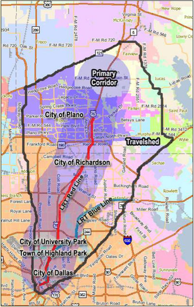
Figure 1.2-1 US-75 Corridor Boundaries (Source: NCTCOG website dfwmaps.com)

1.3. CORRIDOR STAKEHOLDERS AND USERS
The operating agencies located in the US-75 Corridor are all shown below, all of which were involved to some extent in the development of this Concept of Operations. Each agency has a designated lead staff member along with the technical staff in key areas of responsibility. A strong pool of universities supports the team and provides the needed expertise.
Table 1.3-1 below shows the current responsibilities and infrastructure that each agency within the US-75 Corridor currently provides to the region.
| Traffic Related Roles | Texas DOT | City of Dallas | City of Richardson | City of Plano | DART | NTTA | NCTCOG | City of University Park | Town of Highland Park | University team |
|---|---|---|---|---|---|---|---|---|---|---|
| Police | |
 |
|
|
|
|
|
|
|
|
| Fire | |
|
|
|
|
|
|
|
|
|
| Emergency Services | |
|
|
|
|
|
|
|
|
|
| Courtesy Patrol | |
|
|
|
|
|
|
|
|
|
| Traffic Signal System | |
|
|
|
|
|
|
|
|
|
| Surveillance / detectors | |
|
|
|
|
|
|
|
|
|
| DMS | |
|
|
|
|
|
|
|
|
|
| Public Works | |
|
|
|
|
|
|
|
|
|
| CCTV – sharing and control | |
|
|
|
|
|
|
|
|
|
| Electronic toll / fare / parking equipment | |
|
|
|
|
|
|
|
|
|
| Transit – Bus/ LRT/ Train | |
|
|
|
|
|
|
|
|
|
| Parking management | |
|
|
|
|
|
|
|
|
|
| Maintenance/ construction | |
|
|
|
|
|
|
|
|
|
| HOV | |
|
|
|
|
|
|
|
|
|
| Data Warehouse (  = provide data) = provide data) |
|
|
|
|
|
|
|
|
|
|
| Modeling | |
|
|
|
|
|
|
|
|
|
| Internet Traveler Information | |
|
|
|
|
|
|
|
|
|
1.4. NEED FOR INTEGRATED CORRIDOR MANAGEMENT (ICM)
Simply put, the Integrated Corridor Management concept seems to be the only solution for increasing capacity in the Dallas US-75 Corridor. The needs and goals, as detailed in Section 3.8 related transportation operations within the Corridor, are most likely to be met only with operations within each of the separate transportation networks to be coordinated.
The US-75 Corridor consists of multiple independent networks:
- Freeway
- Managed High Occupancy Vehicle (HOV) Lanes
- Tollway
- Arterials
- Bus
- Light Rail
Each of these corridor networks are experiencing congestion to some extent during peak hours. "Integrated Corridor Management" focuses on the operational, institutional, and technical coordination of multiple transportation networks and cross-network connections comprising a corridor. Moreover, ICM can encompass several activities which address the problems and needs identified in the previous section (e.g., integrated policy among stakeholders, communications among network operators and stakeholders, improving the efficiency of cross-network junctions and interfaces, real-time traffic and transit monitoring, real-time information distribution, congestion management, incident management, public awareness programs, and transportation pricing and payment).
The US-75 Steering Committee has identified multiple areas and strategies that would assist in operating the corridor in a more efficient and safe manner and has a positive impact to the overall economy of the region. The first major area deals with information sharing both with the public and among agencies. Currently the region has an ITS Standards based Center-to-Center program with a couple of the agencies integrated. This sharing of information could be used for better informing the public of the operations of the corridor and the availability and impact of different modes. The corridor could provide comparative travel time across modes, so that travelers can make informed decisions about trips they are about to make, this would include the ability to collect and distribute arterial travel time data via various media including through 3rd party ISPs, websites, and subscription services for phones and PDAs.
One of the areas multiple agencies identified that is needed is coordinated response plans and a decision support tool to assist with the on-going operations of the corridor. This decision support tool would be integrated with the various agencies, and provide multi-agency responses to scenarios that have been modeled, agreed to, or meet certain criteria. The agencies will identify hot spots where re-occurring incidents and special events occur, and develop responses that are coordinated and agreed upon by the agencies.
One of the deficiencies that needs to be addressed – and a specific attribute of the Regional ITS Architecture – involves the exchange and sharing of real-time data. With real-time data and video among the networks, each network could monitor the conditions of adjacent networks to anticipate when travelers may shift to their network and take appropriate actions. Moreover, real-time condition information would provide the foundation for corridor-wide traveler information. The corridor has solutions for both of these deficiencies – the current center-to-center project is used by some of the agencies within the corridor, but further expansion to all of the corridor agencies is needed. A Regional Data and Video Communication System is currently being designed that would serve as the central distribution point for sharing video among corridor agencies. Currently several cities, DART, and TxDOT share some of their video images.
Another element of ICM that is needed is outreach and marketing to the public and major employers within the corridor. Currently, many travelers utilize the regional website and 3rd Party ISPs (including Media) to find out about current conditions. One of the strategies identified by the stakeholders is outreach to major employers to provide customized traveler information to them; this could then be used as a potential way to allow diversion of travelers to use their overflow parking.
Another potential element of ICM involves enhanced mobility opportunities, including shifts to alternate routes and modes. Currently, any shifts that do occur are based on traveler knowledge and past experience. Using integrated real-time information, the various networks working as a corridor could influence traveler network shifts; especially promoting, when appropriate, shifts to the rail network with its unused capacity. The one problem with influencing a shift to rail is the parking shortage. Parking notification could be used to direct travelers to available parking; or in some situations temporary parking may be instituted to handle the new demand.
Current and new DMS deployed among the networks could be operationally integrated and messages could be used to provide travelers condition information on all corridor networks so that each traveler can take appropriate action if one or more of the corridor's network's performance is compromised. More can be done with corridor trip travel times to influence traveler shifts, or staggering of the start of travel. For special events, the DMS could be used to direct event attendees to specific event corridor transportation services.
Clearly, there is great potential to enhance current and near-term operations by implementing selected ICM and cross-network strategies. All of these enhancements would not be possible from an independent network operational perspective. The potential strategies identified above indicate that further investigation and design concerning integrated corridor management is warranted.
1.5. ICM VISION, GOALS AND OBJECTIVES
The US-75 ICM Project is a collaborative effort between Dallas Area Rapid Transit (DART), City of Dallas, Town of Highland Park, North Central Texas Council of Governments (NCTCOG), North Texas Tollway Authority (NTTA), City of Plano, City of Richardson, Texas Department of Transportation (TxDOT), the City of University Park and many local emergency service providers. The Team defined the Vision for the Corridor as:
"Operate the US-75 Corridor in a true multimodal, integrated, efficient, and safe fashion where the focus is on the transportation customer."
Using the Vision Statement as a starting point, the US-75 Steering Committee developed four primary Goals for the ICM, and discussed the Objectives and Strategies for each of the Goals. These Goals and Objectives are interrelated such that activities and strategies oriented towards attaining one of the Goals will likely impact the attainment of other Goals and Objectives.
| Goals | Objectives |
|---|---|
Increase corridor throughput – The agencies within the corridor have done much to increase the throughput of their individual networks both from a supply and operations point of view, and will continue to do so. The integrated corridor perspective builds on these network initiatives, managing delays on a corridor basis, utilizing any spare capacity within the corridor, and coordinating the junctions and interfaces between networks, in order to optimize the overall throughput of the corridor. |
|
Improve travel time reliability – The transportation agencies within the corridor have done much to increase the mobility and reliability of their individual networks, and will continue to do so. The integrated corridor perspective builds on these network initiatives, managing delays on a corridor basis, utilizing any spare capacity within the corridor, and coordinating the junctions and interfaces between networks, thereby providing a multi-modal transportation system that adequately meets customer expectations for travel time predictability. |
|
Improved incident management – Provide a corridor-wide and integrated approach to the management of incidents, events, and emergencies that occur within the corridor or that otherwise impact the operation of the corridor, including planning, detection and verification, response and information sharing, such that the corridor returns back to "normal." |
|
Enable intermodal travel decisions – Travelers must be provided with a holistic view of the corridor and its operation through the delivery of timely, accurate and reliable multimodal information, which then allows travelers to make informed choices regarding departure time, mode and route of travel. In some instances, the information will recommend travelers to utilize a specific mode or network. Advertising and marketing to travelers over time will allow a greater understanding of the modes available to them. |
|
1.6. ICM OPERATIONAL APPROACHES AND STRATEGIES
In order to determine the Strategies to meet the Needs, Goals, and Objectives of the US 75 Corridor Stakeholders, several meetings and workshops were completed to ensure that all Stakeholder viewpoints were relayed and considered in the decision-making process by the project US-75 Steering Committee. The activities that were completed as part of developing this Con Ops included:
- Meeting with each Stakeholder agency individually to discuss the US 75 Corridor, the agency's needs and potential Strategies for meeting the Goals
- Multiple project US-75 Steering Committee meetings / workshops to review the findings of the agency meetings, and to the discuss Goals and Strategies for the US 75 Corridor ICM
These scenarios and the Goals, Objectives, and needs of the Corridor also guided the selection of the ICM Strategies for the US 75 Corridor, which are shown in Table 1.6-1 by Goal.
| Goal | Proposed ICM Approach and Strategies |
|---|---|
| Increase corridor throughput |
|
| Improve travel time reliability |
|
| Improved incident management |
|
| Enable intermodal travel decisions |
|
| ICM Strategy | Increase corridor throughput | Improve travel time reliability | Improved incident management | Enable intermodal travel decisions |
|---|---|---|---|---|
| Information Sharing / Distribution | |
|
|
|
| Manual information Sharing | |
|
|
|
| Automated information sharing (real time data) | |
|
|
|
| Automated information sharing (real time video) | |
|
|
|
| Information clearinghouse / Information Exchange Network (corridor networks / agencies) | |
|
|
|
| Corridor-based ATIS database that provide information to users | |
|
|
|
| Access to corridor ATIS database by 3rd party information providers | |
|
|
|
| En-route traveler information devices (DMS, 511, transit PA systems) being used to describe current operational conditions on another network within the corridor | |
|
|
|
| A common incident reporting system and asset management (GIS) system | |
|
|
|
| Decision Support Tools to model responses – pre-planned | |
|
|
|
| Decision Support Tools to model and develop responses in near real-time | |
|
|
|
| Improve Operational Efficiency | |
|
|
|
| Signal priority for transit (e.g., extended green times to buses that are operating behind schedule) | |
|
|
|
| Transit Traveler Information | |
|
|
|
| Multi-modal electronic payment | |
|
|
|
| Multi-agency/multi-network incident response teams and service patrols, along with training exercises for various types of incidents and events | |
|
|
|
| Coordinated operation between traffic signals and rail transit crossings in close proximity | |
|
|
|
| Accommodate / Promote Cross-Network Route & Modal Shifts | |
|
|
|
| Modeling of Mode Shift | |
|
|
|
| Modify arterial signal timing to accommodate traffic shifting from freeway | |
|
|
|
| Mode Shift from roadways to transit (or vice versa) via en-route traveler information devices (e.g., DMS, HAR, "511") Advise motorists of congestion ahead, direct them to light rail / rail transit, & provide real-time information on the number of parking spaces available in the park & ride facility. | |
|
|
|
| Manage Capacity-Demand Relationship – Real-time / Short-Term | |
|
|
|
| Add transit capacity by adjusting headways and number of vehicles | |
|
|
|
| Add capacity at parking lots (temporary lots) | |
|
|
|
| Coordinated scheduled maintenance and construction | |
|
|
|
| Increase roadway capacity by opening HOV lanes during major incidents to all traffic | |
|
|
|
| Modify HOV restriction | |
|
|
|
| Restrict / re-route commercial traffic | |
|
|
|
= Directly Supports Goal
= Indirectly Supports Goal
1.7. ICMS CONCEPT OPERATIONAL DESCRIPTION
The ICMS is the system that will carry out the ICM strategies. In the future, the US-75 Corridor ICMS will provide, to the greatest extent possible, efficient and reliable travel throughout the US-75 Corridor and the constituent networks, resulting in improved and consistent trip travel times. Using cross-network strategies, the US-75 Corridor will capitalize on integrated network operations to manage the total capacity and demand of the system in relation to the changing corridor conditions.
The US 75 ICMS is a system that generates comparative corridor data in real-time on freeways, HOV lanes, arterials, and transit facilities. The system projects corridor operations one hour into the future, analyzes potential corridor operating strategies and their benefits, and communicates recommended response plans back to the corridor operating agencies. Each operating agency is responsible for implementing their part of a response plan; however, the actions and corridor impacts can be monitored from the regional traveler information web site.
The daily operation of the corridor will be an expansion of the existing relationships and operations of the agencies within the region with additional coordination, communication, and responses to congestion and incidents in the corridor; but will now be applied on a permanent basis for day-to-day operations.
All operations among corridor networks and agencies will be coordinated through a corridor Decision Support System interconnected with the Regional Center-to-Center communication network. The US-75 Corridor Steering Committee, as described in Section 1.9, will develop and update corridor response plans for various scenarios that can be expected to occur within the US-75 Corridor.
Communications, systems, and system networks will be integrated to support the corridor and decision support system. Voice, data, video, information, and control will be provided to all agencies based on the adopted protocols and standards for the sharing of information and the distribution of responsibilities.
Traveler information (on websites, DMS, and through the media and ISPs) will be corridor-based, providing information on corridor trip alternatives complete with current and predicted conditions. Travelers will access or be given real-time corridor information so they can plan or alter their trips in response to current or predicted corridor conditions.
Each traveler will be able to make route and modal shifts between networks easily due to integrated corridor information, integrated fare/parking payment system, and coordinated operations between networks. Using one network or another will be dependent on the preferences of the traveler, and not the nuances of each network.
Travelers will be able to educate themselves about the corridor so they can identify their optimal travel alternatives and obtain the necessary assets (e.g., smart card, available parking) to facilitate their use of corridor alternatives when conditions warrant.
1.8. REQUIRED ASSETS AND ICM IMPLEMENTATION ISSUES
The assets and processes that are needed for a more integrated corridor will be prioritized and accounted for when the high-level and detailed level requirements and designs are developed in the future as a part of the systems engineering process. A key component of this prioritization is the corridor models that are in development. These models will be utilized by the committee to review and analyze the proposed strategies, to determine which strategies have the best benefit/ cost ratio for the corridor and are technologically feasible with the existing systems.
| Organizational Entity | Changes and Additions |
|---|---|
| Texas Department of Transportation (TxDOT) |
|
| City of Dallas |
|
| City of Richardson |
|
| City of Plano |
|
| Dallas Area Rapid Transit (DART) - Bus Service |
|
| Dallas Area Rapid Transit (DART) - Rail Service |
|
| Dallas Area Rapid Transit (DART) |
|
| North Central Texas Council of Governments |
|
| North Texas Tollway Authority |
|
The ICM concept represents a paradigm shift for management and operations within the Generic Corridor – from the current partial coordinated operations between corridor networks and agencies, to a fully integrated and pro-active operational approach that focuses on a corridor perspective rather than a collection of individual (and relatively independent) networks. To make this happen, several implementation and integration issues must be resolved. Several of these implementation issues will involve choices that cannot be fully addressed and subsequently resolved until later stages of the systems engineering process (e.g., design, procurement, and implementation).
1.9. US-75 CORRIDOR ICM CONCEPT INSTITUTIONAL FRAMEWORK
In developing the institutional framework, the US-75 Steering Committee considered many configurations and institutional arrangements to continue and improve upon a de-centralized operational model with a centralized decision making body for cooperation and oversight. The concept presented herein represents the institutional framework endorsed by the US-75 Steering Committee. The approach for the US-75 Corridor is to utilize existing institutional cooperation agreements, and expand on them specifically for the corridor.
The management and operations of the corridor and the ICM will be a joint effort involving all the stakeholders. To effectively manage and operate the ICM concept as described in this Con Ops document, the US-75 Steering Committee recommends the creation of a central corridor decision-making body. This body – designated as the US-75 ICM Subcommittee – will consist of leadership level representatives from each of the stakeholders in the US-75 Corridor. Due to the number of agencies involved, the subcommittee is envisioned to be a subcommittee of the Regional ITS Steering Committee. The membership will consist of members from each of the corridor agencies; however, membership will be on a rotational basis so that the size doesn't become too large.
The elected officials for the region are members of the Regional Transportation Council, which provides direction and policy decisions for the members of the US-75 Corridor. A formal recognition of the US-75 ICM Subcommittee will be requested, and a committee charter created to outline its goals. It is envisioned that the US-75 ICM Subcommittee will be a subcommittee of the existing regional ITS Steering Committee.
The US-75 ICM Subcommittee will be the central decision-making body for the corridor, managing the distribution of responsibilities, the sharing of control, and related functions among the corridor agencies. The US-75 ICM Subcommittee will be responsible for establishing the necessary inter-agency and service agreements, budget development, project initiation and selection, corridor operations policies and procedures, and overall administration.
The US-75 Steering Committee discussed how the corridor would be managed from an institutional point of view, and in keeping with the current plans for the region. Since both TxDOT and DART will be operating from the DalTrans advanced transportation management center, and will continue to be connected to the City of Dallas and the City of Richardson, it will serve as the central point of coordination for the US-75 Corridor.
The proposed institutional framework for the US-75 Corridor as described above is shown in Figure 1.9-1, the green shaded boxes (TxDOT and DART) are co-located at the DalTrans Facility, and the blue shaded boxes (City of Dallas and City of Richardson) have direct connections to the DalTrans facility. The US-75 Corridor staffing is summarized in Table 4.9-1.
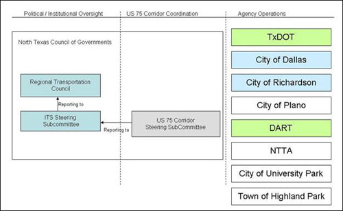
Figure 1.9-1 US-75 ICM Institutional Framework
1.10. SUMMARY
The US-75 Steering Committee is committed to the concepts of ICM and have agreed to continue the pursuit of working in a more coordinated and efficient manner for the US-75 Corridor. The key areas of commitment include focusing on the continued expansion and integration of information sharing between the agencies and the traveling public. The Dallas area understands the need and value for Integrated Corridor Management and is committed toward both short-term deployments and the longer term deployments. As shown in Section 3.5 (Proposed Near-Term Network Improvements) and Section 4.4 (Comparison of ICM Asset Requirements with Current/ Proposed Assets) the agencies in the corridor will be making improvements to the corridor infrastructure that will assist in improving the integration and infrastructure for the corridor.
The US-75 Steering Committee understands the benefits of ICM, and have agreed to continue to work cooperatively to improve the operations of the corridor, the spirit of ICM will continue in the corridor regardless of the funding available through the US DOT ICM Program.