
1. Introduction
In 2001, the U.S. Congress earmarked funds for selected projects that supported improvements in transportation efficiency, promoting safety, increasing traffic flow, reducing emissions of air pollutants, improving traveler information, enhancing alternative transportation modes, building on existing intelligent transportation systems (ITS), enhancing integration, and promoting tourism.
A small number of Fiscal Year (FY) 2001 earmarked projects were selected for national evaluation as part of the U.S. Department of Transportation (USDOT) ITS Integration Program. The purpose of the national ITS evaluation program is to investigate the impacts of ITS across the country and to provide insights into the potential strengths and weaknesses of the overall national integration program. Each evaluation is intended to provide information on the benefits and lessons learned of the project to potentially assist other agencies across the nation who may be considering similar deployments. The Great Lakes ITS (GLITS) program in the Detroit, Michigan metropolitan area was among the projects selected for national evaluation. The FY 2001 GLITS program consists of six major projects designed to integrate current ITS functionality and to deploy additional ITS functionality. Two of the six projects within GLITS, the Detroit Airport ITS Integration and the Wayne County Road Information Management System (RIMS), were the focus of the national evaluation under the direction and partial funding by the U.S. Department of Transportation (USDOT) ITS Joint Program Office (JPO).
The USDOT selected Science Applications International Corporation (SAIC) to conduct an independent evaluation of GLITS projects. The evaluation was intended to be a study of system impacts focusing on traffic mobility, safety, and productivity that was expected to result through the integration of traditional asset management, maintenance, traffic operations, and traffic management functions within a high-density travel corridor.
1.1 Justification for National Evaluation
Originally, the Airport ITS Integration and RIMS projects presented a good opportunity for a successful national ITS evaluation because:
- Substantial funding was already in place and many of the institutional challenges associated with ITS deployment have been addressed through a cooperative process rooted in past projects and driven by a regional ITS vision. Inter-jurisdictional data transfer agreements among project stakeholders have been established to address potential institutional challenges.
- The ITS Airport Integration and RIMS projects provided a unique opportunity to examine new areas of ITS integration.
- Measurable benefits were expected from these evaluations. Specifically, the corresponding traffic flow condition and safety performance were expected to be assessed quantitatively, while the information pertaining to roadway conditions and user satisfaction were expected to be assessed qualitatively.
It was perceived that great opportunities exist in this corridor for ITS integration and to broaden the wealth of knowledge regarding ITS. The "lessons learned" during the course of these deployments will prove valuable to other regions considering similar ITS applications.
1.2 Problem Statement
The Detroit metropolitan area is one of the largest cities in the country and has one of the busiest airports. In terms of population, Detroit is ranked the eighth most populated metropolitan area in the United States according to the 2000 U.S. Census.2 To keep the transportation system and structures (bridges, signs, roadways) repaired, maintained, and operating, Wayne County Department of Public Services (DPS) expends substantial resources annually (approximately $57.6M for operating expenditures in 20053 ). In an effort to improve the quality and efficiency of maintenance operations, coordination between agencies, and other transportation services, the DPS began the development of RIMS to provide seamless access to over 400 databases and support a variety of GIS-related applications.
The Detroit metropolitan area also has one of the busiest airports. Detroit Metropolitan Wayne County Airport (DTW) is the eleventh busiest in North America (and twentieth worldwide) in terms of total passengers for 2005.4 As such, the large number of travelers entering and exiting the airport created a need to improve traffic conditions by reducing internal traffic circulation and improving access to freeways and parking facilities. To address this situation, the Airport ITS Integration project was initiated to monitor traffic conditions, respond more quickly to incidents, and provide real-time traffic guidance within the airport.
1.3 Primary Project Goals and Key Hypotheses
The primary goals of the Airport ITS Integration project are to improve the internal circulation and access needs of airport patrons and integrate the roads and freeways surrounding the airport to ensure efficient airport traffic patterns. The evaluation focused on measuring the impacts of the deployment on increasing mobility, public safety, and customer satisfaction and to identify lessons learned. The key hypotheses for the Airport ITS Integration project are:
- Project assumes real-time traffic data will be made available to the traveling public, thereby contributing to increased mobility.
- Improve safety by informing the traveling public well in advance of incidents, potential hazards, and security issues.
- Project assumes that the real-time information made available through ITS technologies to the traveling public on airport conditions (traffic, parking availability, curbside access, and safety) will contribute to increased customer satisfaction.
The primary goals of the RIMS project are to utilize modern communications technologies to improve public safety and modernize transportation services within Wayne County Department of Public Services (DPS) and improve coordination between the DPS, Michigan Department of Transportation (MDOT), and local units of government within the County. The key hypotheses for the RIMS project are:
- Customer satisfaction will increase as the DPS makes more real-time information available.
- The provision of real-time traffic and roadway condition information will contribute to improved mobility by reducing delays and increasing travel time reliability.
- Using a Geographic Information System (GIS), the RIMS will improve DPS operations by increasing awareness of potential problems; efficiently routing public complaints; providing enhanced responsiveness to in-road maintenance; and reducing design time.
- The RIMS will provide real-time information on traffic and road conditions, ultimately improving safety by informing the traveling public well in advance of incidents and potential hazards (including weather).
The Phase II (baseline) Report for the Great Lakes Intelligent Transportation System Airport ITS Integration Project5 describes the baseline data collected to support the independent evaluation of the associated Airport ITS Integration component of the project. The Airport ITS Integration component is a multi-phased effort that includes the project design, deployment of ITS field device, and integration of an airport Traffic Management Center (TMC). This deployment will facilitate an integrated approach to management of on-field traffic and traffic traveling to and from the DTW on the servicing freeways.
In latter phases of the project, the airport TMC will interface with the MDOT regional TMC and MDOT-owned ITS devices. In its final configuration, the airport TMC will be capable of serving as a backup location for the MDOT regional TMC. The project goal is to optimize traffic flow in and out of the airport, as well as to optimize airport landside traffic flow to terminals and short-term parking facilities.
1.4 Background
The Great Lakes International Economic Corridor comprises all of southeast Michigan from Toledo, Ohio to Flint, Michigan. The area is implementing aggressive, multimodal transportation initiatives to further economic activity and growth within the region. The region supports the U.S. auto industry with a complex network of transportation systems including air, freeway, rail, and waterway links and hubs that connect Detroit with suppliers and customers in the United States and Canada. To date, ITS has been deployed throughout the Great Lakes International Economic Corridor and significant benefits are being realized in the areas of traffic management, incident response, commercial vehicle management, and response to winter weather conditions.6 The GLITS program seeks to integrate previously deployed ITS projects and to design, integrate, and deploy future projects in a stepwise effort to meet the transportation demands peculiar to the region.
1.5 GLITS Program Overview
The GLITS Program is a multiphase program of ITS integration projects in the Great Lakes International Economic Corridor. MDOT is the lead for development and management of this multiphase, multijurisdictional program. Currently, other GLITS partners include:
- The Southeast Michigan Council of Governments (SEMCOG).
- Wayne County (WC).
- The Detroit Metropolitan Wayne County Airport (DTW).
- The Road Commission for Oakland County (RCOC).
- The Detroit Department of Transportation (DDOT).
- The Suburban Mobility Authority for Regional Transportation (SMART).
1.5.1 Airport ITS Integration Project
The Airport ITS Integration project was established for the design and integration of systems to serve airport needs. The ITS effort is an integral part of the ongoing DTW expansion. This project will give the Wayne County Airport Authority (WCAA) the ability to monitor traffic conditions, respond more quickly and appropriately to incidents, and provide real-time traffic guidance within the airport. The airport system also will be integrated with the MDOT Michigan ITS Center (MITSC) to enable real-time traveler incident, congestion, and delay information to drivers heading to and departing from the airport.
The project has two phases. The first is the design and deployment of field devices. This includes developing functional requirements and a Plans, Specifications, and Estimate (PS & E) package to cover procurement, device installation, and testing; a communications infrastructure deployment; and software procurement. These efforts will support the build and implementation of an Airport TMC during the second phase. The second phase consists of architectural design and renovation of the new TMC, along with the design and installation of the associated TMC systems and software; and the design and location of security/surveillance and detection systems.
1.5.2 RIMS Project
The RIMS project leverages current physical and information infrastructure by providing an integrated system that will lead to more efficient maintenance of freeway and arterial systems. Travel efficiency should be improved by providing more consistent and up-to-date signage; improved scheduling of operationally integrated maintenance; timely snow and ice removal; and enhanced accuracy of automated traveler information systems.
The expected result is intended to be an improvement in highway capacity to support the region's high volumes of local, commuter, and commercial traffic. As part of the RIMS effort, Wayne County is working to establish an integrated (GIS) that can integrate nearly 400 currently independent databases used for County operations into one data warehouse. This GIS is being funded with 100 percent County funds.
The primary goals of RIMS are to utilize modern communications technologies to improve public safety and modernize transportation services within the Wayne County DPS and improve coordination between the DPS, MDOT, and local units of government within the County.
1.5.3 GLITS Project Components
Phase I of GLITS involves six ITS projects designed to increase transportation efficiency. The six projects include:
- Completing the Southeast Michigan Regional Architecture to support the region's integration plans.
- Completing the RIMS for Wayne County, Michigan.
- Integrating the DTW with area-wide transportation operations.
- Conducting the I-75 Corridor ITS Integration Study to examine the integration and deployment of an area-wide traffic and incident management system on the I-75 corridor.
- Conducting the M-1/Woodward Avenue ITS Integration Study to develop an integration plan for seamless intermodal operations on Woodward Avenue in Detroit.
- Developing plans to establish the region as an ITS "test bed."
Each of these Phase I projects is important for addressing the major transportation issues in the Southeast Michigan region. The first step is to document the current regional architecture and to provide a mechanism for closure on the objective regional architecture as depicted in Figure 1. The other projects flow out of the regional architecture to address the highest priority integration issues facing this region. For example, the RIMS project should provide benefits to the DPS and serve as a resource for other transportation infrastructure and information users within the region.
A second example is the Airport ITS Integration project, which complements the recent DTW expansion. The expansion included opening a second terminal; opening additional interstate access routes; and improvements in the landside transportation management that will be incorporated into the regional traffic management concept.
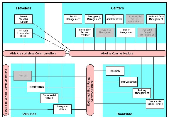
Figure 1. The Southeast Michigan Regional Architecture "Sausage Diagram."
Phase II is focusing on the continued integration of freeway and arterial road operations, enhancing traveler information, intermodal coordination (both passenger and freight), and initial Advanced Traveler Information System (ATIS) "test bed" applications. Phase III will concentrate on further enhancements to the previous deployments, while increasingly integrating commercial vehicle applications and private sector initiatives. In Phase IV, the GLITS stakeholders will procure new arterial management software for State and key local agencies, and a statewide license for freeway management software.
1.6 Evaluation Overview
Initially, the evaluation was intended to be a system impact study to measure or confirm the expected safety, mobility, and customer satisfaction impacts. However, because of unforeseen deployment delays for both the Airport ITS Integration and RIMS projects the evaluation was modified into a case study investigation of key events and the development of lessons learned based on the stakeholders' experiences.
1.7 Evaluation Components
The GLITS project evaluation consists of a case study of system impacts and development of lessons learned based on stakeholder experiences, and recommendations for other jurisdictions and agencies considering a similar deployment. The case study and lessons learned activities included the following tasks:
- Interviews with the GLITS management team.
- Collection of supporting information.
- Development of lessons learned.
- Development of a final Case Study Report.
- Presentation of findings and conclusions to USDOT.
1.8 Report Organization
The remainder of this Final Report document is organized as follows:
- Section 2: The GLITS Project Overview: This section provides an overview description of the DTW Airport ITS Integration and RIMS projects.
- Section 3: Summary of Evaluation Activities: This section provides a summary of the evaluation activities conducted as part of the independent national evaluation of the Airport ITS Integration and RIMS projects.
- Section 4: History of Events: This section describes the key events that affected the deployment of the Airport ITS Integration and RIMS projects. The accounts cited are based on news articles and interviews with the GLITS management team.
- Section 5: Lessons Learned: This section describes lessons that were developed from the GLITS project management experiences from 2002 through early 2007.
- Section 6: Summary and Conclusions: This section summarizes the events and lessons that were learned from the GLITS project management experiences.
- Appendix A: Traffic Flow Data.
- Appendix B: Air Passenger Counts.
- Appendix C: Parking Lot Transactions.
- Appendix D: Vehicle Crashes: February 2002 through January 2004.
2 From U.S. Census 2000 Ranking Tables for Metropolitan Areas: 1990 and 2000 Website, last accessed on February 19, 2007 at: <http://www.census.gov/population/cen2000/phc-t3/tab03.pdf>.
3 From Wayne County Department of Management and Budget Website, last accessed on February 20, 2007 at: <http://www.waynecounty.com/mgtbudget/budgetDocs/2005_06/deptPublicSrvs.pdf#pagemode=bookmarks>.
4 From Airports Council International Website, last accessed on February 19, 2007 at: <http://www.aci-na.org/asp/traffic.asp?art=215>.
5 Phase II Report for the Great Lakes Intelligent Transportation System Airport ITS Integration Project, prepared by Science Applications International for the USDOT, April 28, 2006.
6 Great Lakes ITS Program (GLITS) Final Evaluation Plan, prepared by Science Applications International for the USDOT, June 5, 2003.