![]()
![]()

|
1000 Friends:
Making Land Use Transportation Air Quality Connections
--
The Pedestrian Environment
--
Volume 4A
Click HERE for graphic.
1000 FRIENDS OF OREGON
Making the Land Use Transportation Air Quality Connection
The Pedestrian Environment
Volume 4A
Prepared by
Parsons Brinckerhoff Quade and Douglas, Inc.
with Cambridge Systematics, Inc. and Calthorpe Associates
December 1993
Additional funding provided by
Surdna Foundation, Inc.
The Joyce Foundation
ARCO Foundation
Lincoln Institute of Land Policy
National Endowment for the Arts
Tri-County Metropolitan Transportation District of Oregon
MetroPortland General Electric Company
Home Builders Association of Metropolitan Portland
Pacific Development, Inc.
Key Bank of Oregon
David Evans & Associates, Inc.
Kurt Koehler
The New-Land Foundation, Inc.
C 1993 1000 Friends of Oregon.
Reprint by permission only.
Table of Contents
Introduction ....................................................  1
Summary .........................................................  3
Overview ........................................................  5
Characteristics of the Portland Dataset ......................... 15
Household Travel Relationships .................................. 17
     Travel Mode Choice Relationships ........................... 17
     Vehicle Trip Generation Relationships ...................... 24
Modeling Household Vehicle Trip Choices ......................... 29
     Vehicle Miles Traveled Model................................ 30
     Vehicle Trip Generation Model .............................. 33
Conclusions ..................................................... 35
Acknowledgments ................................................. 37
Appendix A - Portland PEF Scores By Zone
Appendix B - Results of Regression Analysis
The Pedestrian Environment: Volume 4A i
ii The Pedestrian Environment: Volume 4A
List of Tables
Table 1   Distribution of Zones by PEF and Pedestrian Category...  6
Table 2   Travel Mode Choices by Pedestrian Environment Factor... 17
Table 3   Travel Mode Choices by Pedestrian Zone Category........ 21
Table 4   Travel Mode Choices by Zonal Household Density......... 22
Table 5   Travel Mode choices by Transit Level-of-Service
          to Employment.......................................... 23
Table 6   Auto Usage by Pedestrian Environment Factor............ 25
Table 7   Household VMT Model Predicted Impacts.................. 31
Table 8   Equivalent Variable Impacts on VMT Per Household Person 32
Table 9   Household Vehicle Trip Model Predicted Impacts......... 34
The Pedestrian Environment: Volume 4A iiiiv
The Pedestrian Environment: Volume 4A
List of Figures
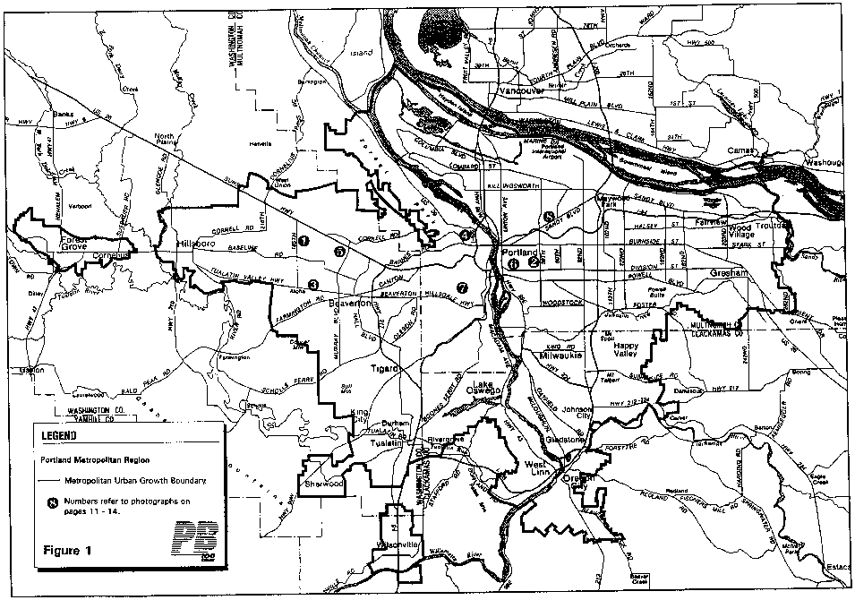
Figure 1 Portland Metropolitan Region .......................... 8
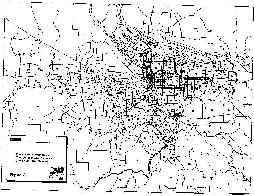
Figure 2 Portland Metropolitan Region Transportation Analysis
Zones ................................................. 9
Figure 3 Pedestrian Environmental Factors (PEF) Scores by Group. 10
Figure 4 Non-Auto Modal Shares by Pedestrian Environment Factor
(PEF).................................................. 18
Figure 5 Non-Auto Modal Shares by Pedestrian Zone Category ..... 21
Figure 6 Non-Auto Modal Shares by Zonal Household Density ...... 23
Figure 7 Non-Auto Modal Shares by Transit Level-of-Service to
Employment ............................................ 24
Figure 8 Household Vehicle Miles Traveled by Pedestrian
Environment Factor (PEF) .............................. 26
Figure 9 Household Vehicle Trips Generated by Pedestrian
Environment Factor (PEF) .............................. 27
Figure 10 Impact of Land Use Variables on Household Vehicles Miles
of Travel (VMT)........................................ 32
The Pedestrian Environment: Volume 4A v
Click HERE for graphic.
Introduction
Introduction
"Making the Land Use, Transportation, Air Quality Connection"(LUTRAQ) is a national demonstration project to develop methodologies for creating alternative suburban land use patterns and design standards and evaluating their impacts on: - automobile dependency,
- mobility,
- air quality,
- energy consumption, and
- sense of community.
Using the proposed Western Bypass freeway around the Portland, Oregon metropolitan region as a case study, LUTRAQ has (1)identified alternative land use development patterns that reduce travel demand and increase the use of alternative travel modes; and(2) developed reliable transportation modeling procedures that forecast the travel behavior associated with these alternative land use patterns. The LUTRAQ project contains six primary tasks:
Task A.   Analyze Current Model Limitations
     In Task A, the project team (1) identified the international
     state-of-the-art of integrated land use/transportation
     modeling; (2) determined current modeling practices in U.S.
     metropolitan areas; and (3) evaluated the modeling system in
     place for the LUTRAQ study area.

Task B.   Analyze the Base Case
     The project team established current land use and
     transportation opportunities and constraints in the study
     area.

Task C.   Develop the LUTRAQ Alternative Package
     The project team is currently establishing two alternatives to
     freeway construction, each containing three primary elements:
     (1) alterations in area land uses, densities, and development
     design standards, (2) expansions in transit facilities and
     services, and selected existing collector/arterial systems,
     and (3) changes in land use and non-land use policies,
     including those related to transportation demand management.

Task D.   Modify the Models
          The team has improved the modeling system in the study
          area to assure accurate measurement of the alternatives
          developed in Task C.
The Pedestrian Environment: Volume 4A 1
Introduction
Task E.   Test the Alternatives
     Using the modeling improvements from Task D, the team is
     analyzing a no-action alternative, the freeway alternative,
     and the LUTRAQ alternative (developed in Task C) for their
     effects on congestion, land use, air quality, energy
     consumption, quality of fife, public finances, and user costs.

Task F.   Implement the LUTRAQ Alternative Package
     The team will prepare a set of recommended actions to
     implement the elements of the alternative developed in Task C.
Work products from the LUTRAQ project include a separate volume devoted to each task, plus a final report and technical appendix.
Volume              Title                         Authors
1            Modeling Practices       Cambridge Systematics, Inc.
                                        and Hague Consulting Group
2            Existing Conditions      Cambridge Systematics, Inc.
                                        and Calthorpe Associates
3            Description of           Cambridge Systematics,
               Alternatives             Inc., Calthorpe Associates
                                        and Parsons Brinckerhoff
3A           Market Research          Market Perspectives and
                                        Hebert/Smolkin Associates,
                                        Inc.
4            Model Modifications      Cambridge Systematics,
                                        Inc., S.H. Putman and
                                        Associates and Parsons
                                        Brinckerhoff
               Interim Report           Cambridge Systematics,
                                        Inc., Calthorpe Associates
                                        and Parsons Brinckerhoff
4A           The Pedestrian           Parsons Brinckerhoff
               Environment
5            Analysis of              Cambridge Systematics,
               Alternatives             Inc., Calthorpe Associates
                                        and Parsons Brinckerhoff
6            Implementation           Cambridge Systematics,
                                        Inc., Calthorpe Associates
                                        and Parsons Brinckerhoff
7            Final Report             Cambridge Systematics,
                                        Inc., Calthorpe Associates
                                        and Parsons Brinckerhoff
8            Technical Appendix       Cambridge Systematics,
                                        Inc., Calthorpe Associates
                                        and Parsons Brinckerhoff
2 The Pedestrian Environment: Volume 4A
Summary
This report analyzes the connection between land use patterns and household travel behavior in the Portland area. Data from the 1985home interview survey conducted by Metro (the Portland area regional government) as well as results from the regional travel forecasting models and land use information were used to test the hypothesis that travel behavior is affected by neighborhood land use patterns. Special attention was given to the quality of the pedestrian environment as gauged by the Pedestrian Environment Factor (PEF), a composite measure of "pedestrian friendliness". The first part of this report examines and quantifies the relationships between household travel mode choices and the following variables -- quality of the pedestrian environment, residential density, transit level-of-service, and proximity to employment activity. In addition, variations in the quantity and length of vehicle trips were examined. The results of this exercise confirm the direct correlation between the use of pedestrian and transit travel modes and the land use variables identified above. As expected, residents in neighborhoods with higher density, proximity to employment, grid pattern streets, sidewalk continuity, and ease of street crossings tend to make more pedestrian and transit trips, whereas residents of more distant, lower density suburban areas with auto-oriented land use patterns show extensive reliance on the auto. In the second part of this report, multiple regression techniques are employed to confirm statistically the hypothesis that these land use variables do in fact impact household mode choice decisions. Regression models were developed to explain both daily household vehicle miles traveled (VMT) and vehicle trips generated. Although constraints in the level of detail and variability in the available data limit the overall explanatory power of these models, the land use related variables, including the PEF, are shown to significantly impact both household VMT and the number of vehicle trips.
Specifically, the models suggest that a 10% reduction in VMT can be achieved with a region wide increase in the quality of the pedestrian environment to a level comparable to that currently available on Portland's most pedestrian-oriented zones today. These zones form a larger contiguous area with densities supportive of transit, land use mixes which reduce auto use, and an orientation to the needs of pedestrians, as more fully described in this report. These findings are consistent with results of simulations conducted for the LUTRAQ project, described in "The LUTRAQ Alternative/Analysis of Alternatives: An Interim Report"(October 1992).
The Pedestrian Environment: Volume 4A 3
Click HERE for graphic.
4 Overview
This volume is a supplement to Volume 4 of the LUTRAQ Project, issued in November, 1992. In that report the authors describe several travel model enhancements made to the forecasting system used by Metro in Portland, Oregon. Of greatest relevance here is a description of a new variable, called the "Pedestrian Environmental Factor" (PEF). This measure is a composite of four different attributes of the natural and built environment, which were shown to improve the accuracy of several submodels in the Portland system. In particular, the pre-mode choice model (walk/bike vs .motorized modes) was enhanced by the introduction of the PEF measure into the set of equations on which the model was calibrated. As developed by the Metro staff in consultation with the LUTRAQ Consultant Team the PEF consists of an assessment of each of 400zones in the regional travel demand forecasting model network for each of the four following parameters:
- Ease of street crossings
- Sidewalk continuity
- Local street characteristics (grid vs. cul de sac)
- Topography
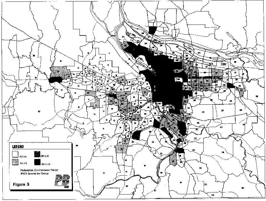
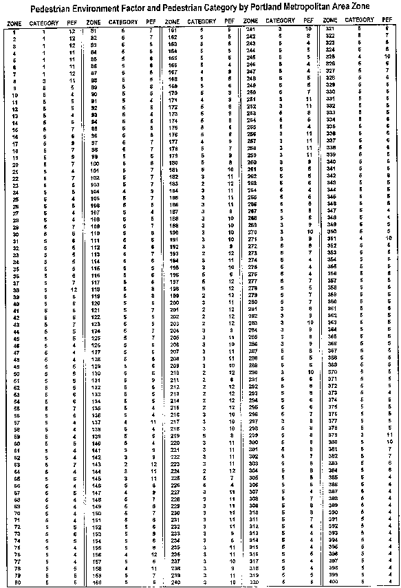
To estimate ease of street crossings at the zonal level, staff identified key intersections and evaluated their width, extent of signalization and traffic volumes. For a measure of sidewalk continuity, staff judged the extensiveness of sidewalks on principal arterials served or likely to be served in the future by transit. Secondary attention was paid to the extent of sidewalks on neighborhood collector streets. As a measure of connectivity of street systems, staff estimated the extent of grid street patterns in each zone. They also examined the fineness of the grid(distance between intersections). As a measure of topography staff evaluated the extensiveness of sloping terrain and the steepness of these slopes. Each zone in the model system was scored on a three point scale for each of the four characteristics named above. A composite score(four-12) was created for each zone, with 12 being the highest possible and four the lowest. Four different staff completed this exercise independently and then compared results in order to enhance the objectivity of the analysis. Some zonal scores were modified on specific parameters to reflect a consensus reached on their characteristics. This simplified Delphi approach resulted in consensus on rankings for the entire network of zones. Table 1 summarizes the distribution of pedestrian environmental factor scores. Figure 2 shows the location of the 400 traffic analysis zones used in the analysis and Figure 3 summarizes the distribution of the PEF scores associated with each of them.
The Pedestrian Environment: Volume 4A 5
Overview
                               Table 1
        Distribution of Zones by PEF and Pedestrian Category

               PEDESTRIAN                                     NUMBER
               ENVIRONMENT                                        OF
                 FACTOR                                        ZONES
                    4                                            66*
                    5                                            96
                     6                                            64
                     7                                            40
                     8                                            30
                     9                                            26
                     10                                           20
                     11                                           37
                     12                                           21
                     TOTAL                                       400*

*    16 of the 400 Transportation Analysis Zones are
          considered external to the Portland Metropolitan Area
The PEF was determined to be a statistically significant variable in the equations of the model into which it was introduced. Specifically, the use of the PEF improved the model's ability to explain variation in auto ownership, mode choice and destination choice. This supplement to the Volume 4 report is designed to explain the importance of neighborhood-level land use characteristics, particularly PEF, on travel behavior in more understandable terms.
1A number of studies have demonstrated the relationship between residential densities and mode choice, beginning most significantly with Pushkarev and Zupan (1977) and followed by Smith (1984),Potter (1984), Newman and Kenworthy (1989) and others
2. Today the significance of residential density in mode choice models is a fairly settled question. Portland's travel demand forecasting models include several measures of density already. Several research projects in the last several years have suggested a relationship between residential densities at the neighborhood or subregional scale and automobile use, expressed in terms of vehicle miles of travel per households
3. The evidence for this
___________________
     1.   The reader is directed to the Volume 4 report for a more
          comprehensive presentation of the role of land use
          variables in the Metro regional forecasting model.  The
          volume also presents an independent confirmation of the
          statistical significance of these land use variables,
          using more complex methods than those described in this
          report.
     2.   Pushkarev, B., and J. Zupan, Public Transportation and
          Land Use Policy.  Bloomington, Indiana University Press
          (1977).  Smith, W., "Mass transit for High-Rise, High
          Density Living".  Journal of Transportation Engineering.
           110, 6 (1985) pp. 521-35.  Potter, S., "The Transport
          Versus Land Use Dilemma".  Transportation Research Record
          964.  (1984) pp. 1-8.  Newman, P., and J. Kenworthy,
          "Gasoline Consumption and Cities:  A comparison of U.S.
          Cities with a Global Survey".  Journal of the American
          Planning Association.  55, 1. (1989) pp. 24-37.
     3.   Harvey, G., Relation of Residential Density to VMT Per
          Resident:  Oakland.  Metropolitan Transportation
          Commission (1990).  Holtzclaw, J., "Manhattanization
          versus Sprawl: How Density Impacts Auto Use Comparing
6 The Pedestrian Environment: Volume 4A
Overview
relationship, while clear, has been less than compelling because several social and economic measures which are known to explain automobile use, such as the number of workers per household, the rates of auto ownership, household income, household size and age of the household head, were not included in the studies. In addition, very few studies have been published to date on the role of pedestrian infrastructure in affecting mode choice decisions.4Thus, a principal objective of this report is to extend the current state of knowledge on the relationship between land use characteristics at the neighborhood or zonal level and measures of travel behavior, including mode choice and automobile use, by controlling for effects of socioeconomic variables known to influence this behavior. While the first part of the report presents a series of descriptive statistics on these relationships, the regression results presented in the second half of the report are designed to address more rigorously the question of the role of land use on trip length, vehicle trip generation rates and vehicle miles traveled.
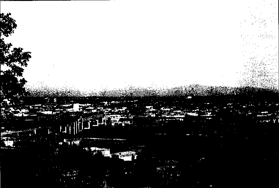
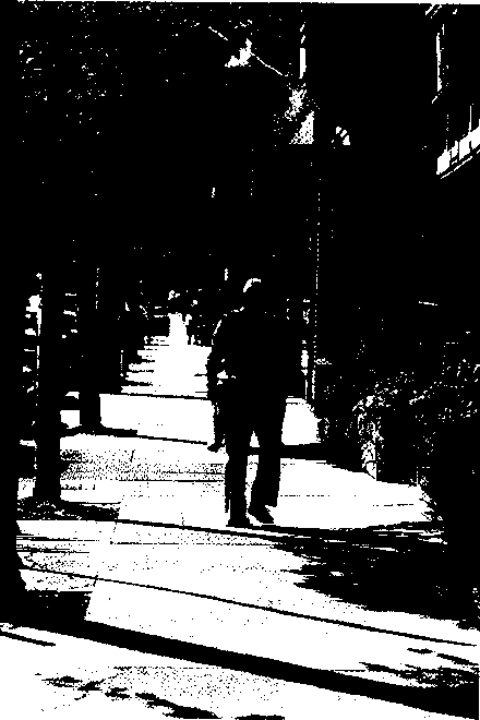
Before introducing the results of the analysis, it is appropriate to describe the context in which the analysis was conducted. The following pages contain three maps. The first (Figure 1) is a generalized map of the Portland metropolitan area, indicating basic landmarks, jurisdictions and the primary road network. Following this is a map (Figure 2) showing the 400 traffic analysis zone system used by Metro for travel demand modeling. The map in Figure3 shows the composite PEF rating for each of the 400 analysis zones. To further illustrate the components of the PEF rating system, a series of photographs are provided following the maps. The locations of the areas depicted in the photos are indicated on the Figure 1 map. Finally, a detailed description of the data set used for the analysis is provided.
___________________________
          Five Bay Area Communities".  Proceedings of the Eleventh
          International Pedestrian Conference.  Boulder, Colorado,
          City of Boulder (1990) pp. 99-106.
     4.   Pushkarev, B., and J. Zupan, Urban Space for Pedestrians,
          Cambridge, MA, MIT, Press (1975).  Stringham, M., "Travel
          Behavior Associated with Land Uses Adjacent to Rapid
          Transit Stations".  ITE Journal, 52, 4 (1982) pp. 18-22.
           Untermann, Richard, "Adapting Neighborhoods for Walking
          and Bicycling".  Accommodating the Pedestrian, Van
          Nostrant Reinhold (1984).
The Pedestrian Environment: Volume 4A 7
Click HERE for graphic.
8 The Pedestrian Environment: Volume 4A
Click HERE for graphic.
The Pedestrian Environment: Volume 4A 9
Click HERE for graphic.
10 The Pedestrian Environment: Volume 4A
Overview
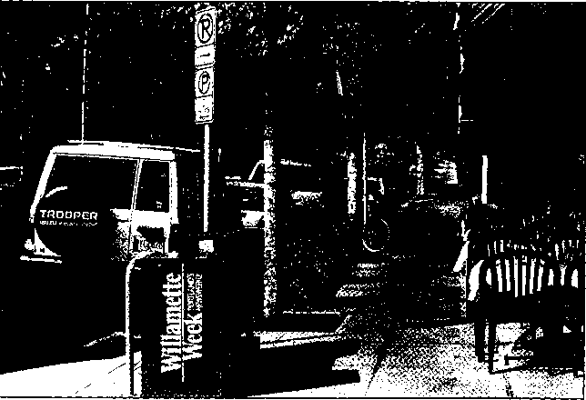
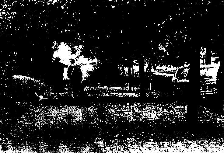
Factor No. 1:Ease of Street Crossing
"Why did the chicken cross the road?"
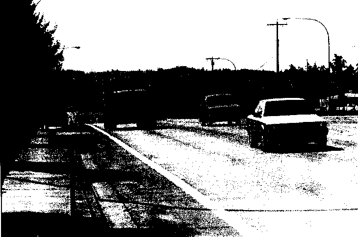
One of the key indicators of the quality of the pedestrian environment is the degree to which one may safely cross the street. In analyzing this factor, key intersections were evaluated for their width, extent of signalization and traffic volumes.
Click HERE for graphic.
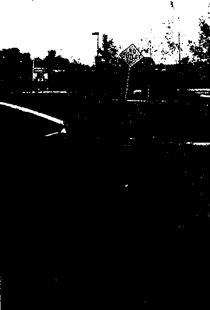
Photo 1:  Although sidewalks are present along this stretch of N.W.
          185th Street in Hillsboro, the street received a rating
          of 1 (the lowest score) for ease of street crossing
          because of the width of the street, the long distances
          between traffic signals, and the high level of traffic.
          photo:    Keith Bartholomew
Click HERE for graphic.
Photo 2:  By contrast, this section of Portland's S. E. Hawthorne
          Boulevard was given a rating of 3 (the highest score) for
          street crossing because the street is relatively narrow
          with frequent signals.
photo:    Anne Weaver
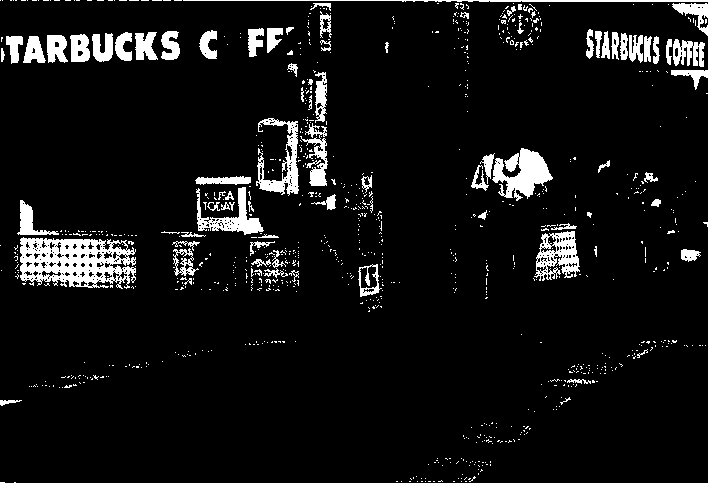
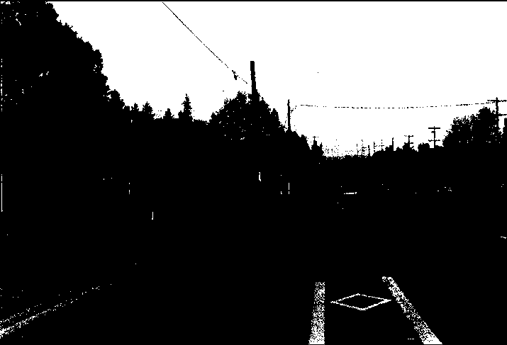
Note: Figure 1, p. 8 shows the geographic location of sites depicted in photos 1-8
The Pedestrian Environment: Volume 4A 11
Overview
Factor No. 2: Sidewalk Continuity
"Trip the light fantastic? "
The most obvious factor in determining the quality of the pedestrian environment is the presence (or absence) of a continuous sidewalk network.
Click HERE for graphic.
Photo 3:  Although there are sidewalks along some properties that
          adjoin the Tualatin Valley Highway, the lack of sidewalk
          continuity presents a barrier to pedestrians, thus
          resulting in a rating of 1 for this area.
photo:    Keith Bartholomew
Click HERE for graphic.
Photo 4:  In northwest Portland, a continuous sidewalk network
          provides the basic infrastructure for walking, and
          consequently was rated "3 " for this factor.
photo:    Keith Bartholomew
12 The Pedestrian Environment: Volume 4A
Overview
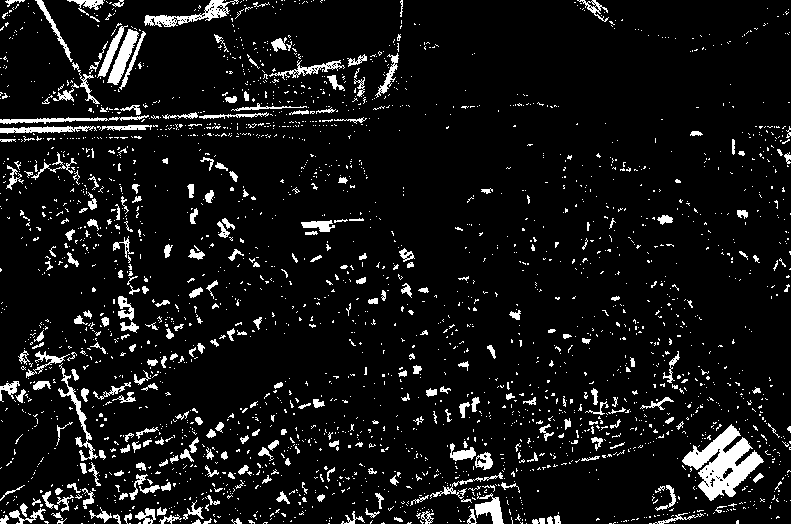
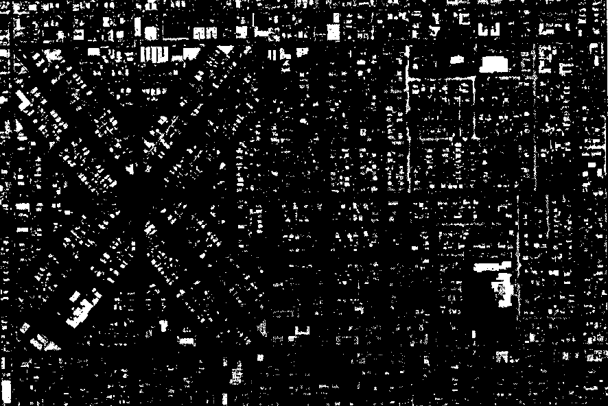
Factor No. 3:Street Connectivity
"Can you get there from here?"
Another basic element of the pedestrian environment is the degree to which streets-and hence, sidewalks--are connected to each other. Streets with numerous connections to other streets tend to offer the pedestrian a more direct route than streets with cul-de-sacs, dead ends, long blocks and circular patterns.
Click HERE for graphic.
Photo 5:  The area surrounding the Highway 26 and Cedar Hills
          Boulevard interchange in Washington County is a classic
          illustration of a lack of continuity.
Aerial photos: WAC Corporation, Eugene, Oregon
Click HERE for graphic.
Photo 6:  This southeast Portland neighborhood, on the other hand,
          illustrates a well-connected street pattern.
Aerial photos: WAC Corporation, Eugene, Oregon
The Pedestrian Environment: Volume 4A 13
Overview
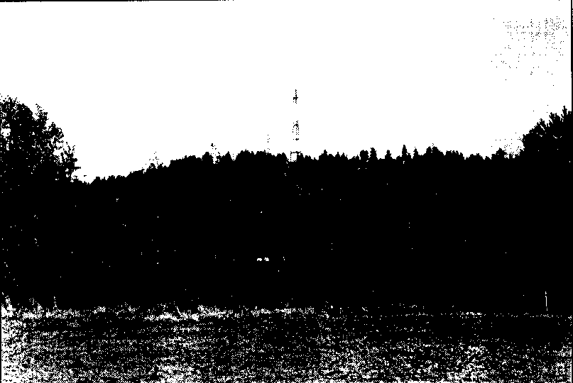
Factor No. 4: Topography
"So high you can't get over it?"
Lastly, the degree to which an area contains steep slopes can affect its pedestrian friendliness. While there is little that public policy can do to change topography, it is, nevertheless, a factor.
Click HERE for graphic.
Photo 7:  Naturally, the Tualatin Mountains, which run through the
          region's mid-section, present a topographical pedestrian
          barriers.
photo:    Keith Bartholomew
Click HERE for graphic.
Photo 8: The majority of the region, however, is relatively flat.
photo:    Keith Bartholomew
14 The Pedestrian Environment: Volume 4A
Characteristics of Portland Dataset
Characteristics of the Portland Dataset
The dataset used for this analysis of the land use impacts on household travel behavior is derived largely from Portland Metro's1985 home interview travel survey and the regional travel forecasting models. Although this dataset contains a variety of useful and interesting information, certain constraints in the detail of many of the variables make it challenging to use this dataset for explaining travel behavior. Data such as income and auto ownership, which originate from the survey responses, are specific to each household. Survey responses to trip information are even more specific, providing detail on trip distances, purposes and frequency by individual household members. Conversely, several key variables regarding land use, accessibility, employment activity and residential density are only available aggregated to 384 transportation analysis zones, thereby grouping together several potentially dissimilar households.5 As a result, the analysis was constrained to look at overall travel behavior, rather than trip purpose or origin, for the over 2,400households represented in the dataset. In addition, the dataset may not fully represent a typical cross section of Portland households. Although the survey was administered to nearly 5,000 households at random in all zones, complete coding of survey responses, including geo-coding of tri information, was only performed for households that indicated at least one or more members making a transit trip. Only about half of the remaining majority of households (that did not use transit)had their surveys completely coded. The inclusion in the sample used in this research of all households who made a transit trip and only approximately half of the households who did not make a transit trip on the survey date may introduce a sampling bias. However, the over-representation of households that use transit should not be a significant problem affecting the reliability of conclusions, given that the study controls for auto ownership, income and other socioeconomic variables. Such a bias will be present only if we assume that there exists some immeasurable aspect to mode choice decisions which operates solely for households who manifest a willingness to take transit. Another shortcoming in the data is the under-representation of the walk or bicycle trips. The survey dataset only includes pedestrian mode or non-motorized trips of distances longer than six blocks. However, in areas of high density and mixed uses, many trips/trip purposes can be accommodated within a six block radius without using auto or transit modes. Since the purpose of this analysis is examine how land use patterns affect travel behavior, this gap in the dataset most likely leads to underestimation of the role that higher density and pedestrian friendly areas play in reducing reliance on the auto.
___________________________
5.   Complete land use and demographic information was available
     for only the 384 Internal zones of the 400 total analysis
     zones used by the Portland Metro travel forecasting model.
      The other 16 zones are outside the regional boundaries.
The Pedestrian Environment: Volume 4A 15
Click HERE for graphic.
Household Travel Relationship
Household Travel Relationships
-- Travel Mode Choice Relationships
Information on over 15,000 trips generated by more than 2,400households was used to examine the relationship between zonal land use patterns and the mode of transportation chosen for each trip. Auto, transit, walk/bicycle and other modes of travel were compared across four measures of zonal land use characteristics: two categorizations of PEF, household density and transit level-of-service as measured by employment accessibility via 30 minutes transit. While a whole host of variables affect people's transportation choices, including a variety of land use, geographic and socioeconomic factors, it is illustrative to examine the distribution of travel mode choices for individual measures of land use.
Pedestrian Environmental Factors
Table 2 lists travel mode choice statistics over the range of values for the PEF. The data clearly shows that households in zones with higher PEF'S, i.e., pedestrian friendly areas, tend to generate more transit, bicycle and walk trips, and fewer auto trips. In fact, households in zones with PEF values from nine to12 make over three times as many transit trips and nearly four times as many walk and bicycle trips as households located in zones with PEF values from four to eight. Alternatively, the latter group of households makes about 94 percent of their trips by auto as opposed to only 80 percent for households in the higher PEF zones.
                               Table 2
        Travel Mode Choices by Pedestrian Environment Factor

PEDESTRIAN
ENVIRONMENT    AUTO      TRANSIT   WALK/     OTHER     TOTAL FACTOR
                             BICYCLE(PEF)
4         1,308 94.2%    35 2.5%   30 2.2%   16 1.2%   1,389 100.0%
5         2,400 94.7%    59 2.3%   41 1.6%   35 1.4%   2,535 100.0%
6         2,607 94.3%    95 3.4%   38 1.4%   25 0.9%   2,765 100.0%
7         1,788 91.3%    98 5.0%   43 2.2%   30 1.5%   1,959 100.0%
8         1,103 92.3%    46 3.8%   35 2.9%   11 0.9%   1,195 100.0%
9         1,067 86.7%    96 7.8%   43 3.5%   24 2.0%   1,230 100.0%
10          771 83.3%    98 10.6%  40 4.3%   17 1.8%     926 100.0%
11        1,796 76.3%   296 12.6% 225 9.6%   37 1.6%   2,354 100.0%
12          625 79.6%    84 10.7%  58 7.4%   18 2.3%     785 100.0%
All      13,465 88.9%   907 6.0%  553 3.7%  213 1.4%  15,138 100.0%
Trips which involve more than one mode (auto, transit or walk/bicycle) have been grouped into the mode "other". Included in this mode are trips using equal combinations of auto, transit and pedestrian modes such as auto-transit trips (driving to a park and ride lot and then
The Pedestrian Environment: Volume 4A 17
Household Travel Relationships
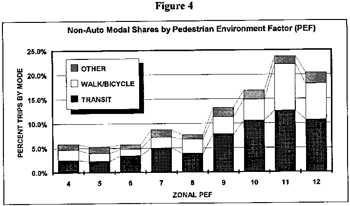
taking transit). In addition, this category includes school bus and tax trips. Other-mode trips account for less than two percent of all trips, and do not vary significantly with zonal PEF. Figure 4 graphically depicts the non-auto mode shares of household trips by zonal PEF. In general, there is an upward trend in the use of pedestrian and transit modes as PEF increases, becoming particularly pronounced as the PEF value exceeds eight.
Click HERE for graphic.
Contrary to expectations, it is interesting to note that the proportion of transit and pedestrian trips is lower for zones with PEF values of 12 than for those with PEF values of 11. A possible explanation arises from the fact that a much higher proportion of trips generated from PEF-12 zones are from households within the central business district than for trips generated from PEF-11zones. It is conceivable that for several households in centralPEF-12 zones, more trips/trip purposes could be accommodated by walking less than six blocks than for other areas where similar trips would involve longer distances and/or other modes. However, trips shorter than six blocks are not accounted for in the survey dataset. Therefore the PEF-12 zones probably generate more short pedestrian and even transit trips than indicated by this dataset.
Pedestrian Zone Categories
Travel mode choices were also examined by pedestrian zone category, a five category measure of pedestrian friendliness which groups together neighborhoods in various geographic locations, taking their pedestrian character into consideration. This approach
18 The Pedestrian Environment: Volume 4A
Household Travel Relationships
takes on meaning in the context of Portland when one considers the relationship between regional location and pedestrian amenities. The City of Portland accounts for approximately half of the metropolitan population on the Oregon side of the Columbia River. The oldest settled areas of the city were developed in large part as "streetcar suburbs," supported by a large network of horse drawn and then eventually electrified trolley service. As was the case of other eastern cities of the same age, the residential developments were improved by the same companies that owned and operated the transit services. Thus, in the parts of Portland laid out and settled before the Second World War, typical blocks are 200 feet on a side. A grid street pattern dominates. Most neighborhoods are relatively flat topographically. The central business district was revitalized in the 1970's with a well known set of pedestrian and transit oriented enhancements, including parallel transit malls, wide sidewalks, extensive street plantings and benches, transit shelters, a light rail system which operates on surface streets and a variety of other amenities oriented toward the pedestrian. The central business district traffic analysis zones in this study are all ranked highest in the region in terms of their pedestrian environmental conditions. (The unique amenities of the CBD do not affect its score; the score is based only the four basic attributes listed on page 5).It should also be noted that the central business district differs not only in terms of its high level of employment and high level of pedestrian amenities, but also in terms of the socioeconomic characteristics of its residents. Residents within the CBD include a large number of small households, many of whom have low incomes. These include a significant number of students attending Portland State University, the urban campus of the state university system, as well as single person households who are not students. This mix of residents, perhaps typical of many central business districts, has a set of travel behaviors (described below) which can be found in other less pedestrian friendly locations whose social and economic characteristics match the ones described above. In addition to the central business district, most of the neighborhoods within approximately five miles of the central business district on the east side have PEF scores of 10 and 11.These zones did not receive the highest score (12) because of localized topographic conditions, though other factors, such as arterial street widenings, adversely affected scores in some zones. Thus, the City of Portland today displays a contiguous core area of five to seven miles square in which there exists a built and natural environment conducive to pedestrian activity. Outside the City of Portland, however, there exist only a few small city centers which exhibit an attractive pedestrian environment, largely because they were developed in an era when automobiles did not dominate as a transportation mode. These small city centers are relatively isolated from one another. They have been merged since World War II in a fabric of suburban development which is auto oriented.
The Pedestrian Environment: Volume 4A 19
Household Travel Relationships
Thus, for purposes of this analysis, the historic development patterns described above were used as the basis for developing five categories of pedestrian zones. The five categories are as follows:
1. Central Business District (PEF = 12)
2. City of Portland (outside CBD) - very pedestrian friendly (PEF = 12)
3. City of Portland (outside CBD) - pedestrian friendly (PEF = 9-11)
4. Outside the City of Portland - pedestrian friendly (PEF = 9-12)
5. Non pedestrian friendly (PEF = less than 9)
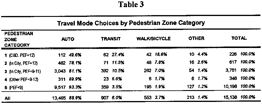
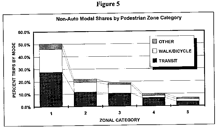
Categories 2 and 3, as implied by Figure 3, are neighborhoods developed before the Second World War, largely located on the eastside of the Willamette River. The central business district, while not delineated separately on Figure 3, consists of that portion of the city within and surrounded by I-405. The pedestrian friendly pre-war neighborhoods in small cities around Portland stand out, as a result of their scores, on Figure 3. The majority of the traffic analysis zones, where development has been oriented toward the automobile, appear unshaded on that figure. Table 3 lists travel mode choice statistics over these five categories. As in the case of Table 2 and Figure 4, the more pedestrian friendly the environment in a category of place, the greater the proportion of trips that are made by transit and walk/bicycle modes. The impact of the pedestrian environment on travel behavior is even more pronounced in the pedestrian zone categories than in the fully disaggregated analysis of PEF scores. Comparing the categories, over 93 percent of all trips are made by auto for households located in auto-dependent places, compared to less than 50 percent for the CBD. Similarly, very pedestrian friendly places in Portland outside the CBD generate proportionately more non-auto trips than their less pedestrian friendly counterparts. In-City zones also generate more non-auto trips than surrounding area zones with comparable PEF values. The data in Table 3 and Figure 5 suggest that pedestrian friendly zones isolated in a large expanse of auto-oriented suburban development cannot support the level of pedestrian, bicycle and transit activity that comparable neighborhoods can support when located adjacent to other neighborhoods with similar characteristics. In other words, the extensiveness of pedestrian oriented development is also an influence on mode choice.
20 The Pedestrian Environment: Volume 4A
TABLE 3
Click HERE for graphic.
This suggests that the creation of isolated new pedestrian oriented developments on vacant sites in auto-oriented suburbia will not produce the same kind of effects on mode choice that traditional neighborhoods have produced, unless the supportive pedestrian environment is integrated, through transportation and land use planning, with proximity to a large number of employment opportunities and an adjacent network of other pedestrian oriented neighborhoods. The effect of the presence of all of these land use factors appears to be greater than the sum of its parts.
Figure 5 illustrates the non-auto modal shares by pedestrian zone category.
FIGURE 5
Click HERE for graphic.
The Pedestrian Environment: Volume 4A 21
Household Travel Relationships
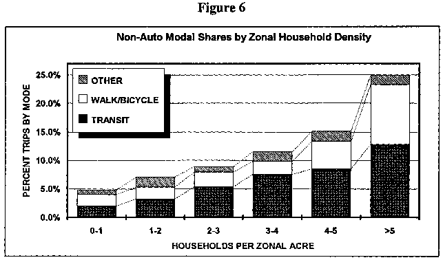
Density
Residential density, measured as the number of households per acre for each zone in the survey dataset, was also examined as a land use variable affecting travel behavior and mode choice.
                               Table 4
           Travel Mode Choices By Zonal Household Density
HOUSEHOLD DENSITY(NO. PER                                       WALKZONAL       AUTO       TRANSIT    BICYCLE      OTHER       TOTALACRE)*
0-1       2,575  25.2%   55  2.0%   54  2.0%  22 0.8%  1,706 100.0%
1-2       3,144  93.0%  110  3.3%   69  2.0%  59 2.0%  3,382 100.0%
2-3       1,878  91.1%  169  5.4%   80  2.5%  31 1.0%  3,158 100.0%
3-4       1,925  88.5%  164  7.5%   50  2.3%  37 1.7%  2,176 100.0%
4-5       1,334  84.9%  134  8.5%   76  4.8%  28 1.8%  1,572 100.0%
>5        1,609  75.0%  275 12.8%  224 10.0%  36 1.7%  2,144 100.0%
All      13,465  88.9   907  3.7%  553  1.4% 213 1.4% 15,138 100.0%
*Zonal Acre" refers to the total land area of a one, inclusive of roads, public land, undeveloped and developed land. In any one zone, residential acreage many account for 30 -80 percent of zonal acreage. Furthermore "residential acreage" may also include streets and roads. Thus, the relationship between total households per zonal acre, and households per net residential acre (a common measure of density) is difficult to generalize. For a more comprehensive analysis of residential density and associated travel behavior in the region, see the "Interim Report" for this project(October, 1992).Table 4 compares ranges of household density by zone across travel modes. As expected, the less dense zones (found in the suburban and outlying areas) generate more auto trips than urban zones with their higher densities. Of the 162 zones with fewer than one household per acre, only four percent of all trips use transit or walk/bicycle modes. This compares to over 19 percent transit and walk/bicycle trips for the 58 zones with a density of four or more households per acre. Figure 6 illustrates the trend of greater non-auto modes use as household density increases.
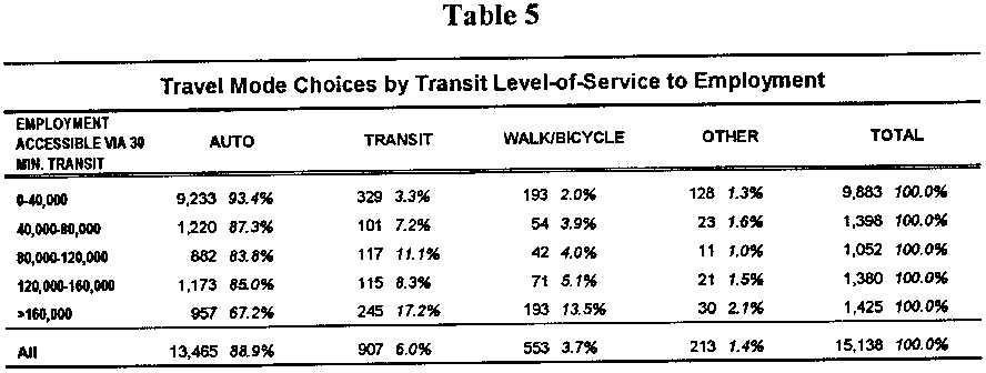
Transit Service
Transit level-of-service, expressed as the quantity of employment accessible by no more than a 30 minute transit trip, is another land use descriptor compared across household mode choices. Employment accessibility via transit measures not only transit level-of-service and pedestrian access, but also the zone's distance to major activity centers, in particular, the Portland CBD where the majority of region's employment is located. As expected, Table 5 generally shows that the closer a household is to employment activity and/or the
22 The Pedestrian Environment: Volume 4A
Household Travel Relationships
transit service from the household zone to major employment areas, the greater the transit and walk/bicycle shares of all household trips. Figure 6
Click HERE for graphic.
One interesting exception occurs for zones with 30 minute employment accessibility via transit in the range of 120,000-160,000. This category of zones produces less transit trips than the category one step lower. The average zonal PEF values and the average employment levels within one mile of the zone centroid are nearly identical for these two categories of zones, which might explain why the 120,000-160,000 category doesn't produce relatively more transit trips, but not why it actually produces relatively fewer transit trips than the 80,000-120,000 category.
TABLE 5
Click HERE for graphic.
The Pedestrian Environment: Volume 4A 23
Household Travel Relationship
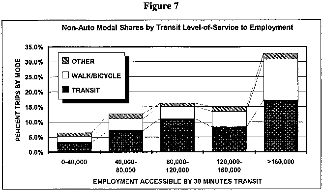
Figure 7 depicts how non-auto trips vary with transit level-of-service to employment centers. One can conclude that zones with good transit service and readily accessible employment activity promote greater use of transit and pedestrian modes. In Portland, the area located in and around the central business district contains the largest concentration of employment activity in the metropolitan area. Approximately 15 % of the region's600,000 jobs are located within the central business district, with an additional 10% located in industrial and office districts proximate to the CBD, east of the Willamette River. These include the east side industrial district and the Lloyd Center office district, among others. Thus, the data in Table 5 is implying that proximity to the central business district by transit is a determinant of mode choice.
Figure 7
Click HERE for graphic.
-- Vehicle Trip Generation Relationships
An alternative way to examine the relationships between land use patterns and travel behavior is to analyze how specific measures of household auto usage-vehicle trips made and vehicle miles traveled(VMT)-vary with zonal PEF values as well as the pedestrian zone category. Table 6 shows how household auto usage in terms of VMT and vehicle trips vary with the PEF values. Under the assumption that a household's propensity for auto use would be lower in pedestrian friendly areas, then one would expect not only VMT, but the number of vehicle trips to decrease as pedestrian friendliness rises. Table 6 confirms this expected relationship.
24 The Pedestrian Environment: Volume 4A
Household Travel Relationships
                               Table 6
        Auto Usage Daily VMT by Pedestrian Environment Factor
PEDESTRIAN                                   VEHICLE TRIPS  VEHICLEENVIRONMENT       VMT PER        VTM PER     PER       TRIPS PERFACTOR (PEF)     HOUSEHOLD        PERSON     HOUSEHOLD   PERSON4
              38.3           16.3           6.5            2.75
              36.7           14.3           6.1            2.46
              32.4           13.8           5.9            2.57
              31.3           12.8           5.8            2.48
              26.7           11.3           5.6            2.39
              22.3            9.7           5.1            2.210
              21.5            9.9           5.0            2.211
              18.1            7.9           4.5            1.912
              18.0            8.1           4.4            2.0
Weighted      30.6           12.8           5.7            2.4
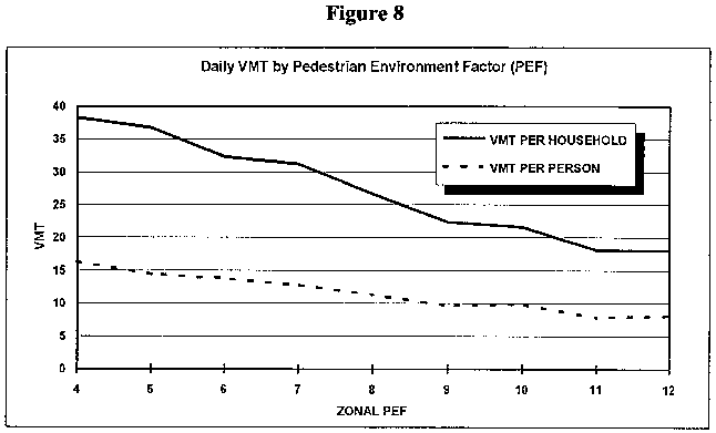
Average
Figure 8 charts the pattern of household VMT and VMT per household person over the range of zonal PEF values.6 VMT per person is included to account for different household sizes between zones. As expected, VMT drops significantly as the PEF values increase, although some of this effect is likely attributable to geographic location. Since many of the high PEF zones are in-City and relatively close to employment activity, it is not surprising that trips associated with the more suburban and outlying zones with their generally lower PEF values tend to be longer, thereby increasing household VMT.
___________________________
6.   VMT per person data does not account for ridesharing whereby
     the trip distance is equally divided by the number of vehicle
     occupants.
The Pedestrian Environment: Volume 4A 25
Household Travel Relationships Figure 8
Click HERE for graphic.
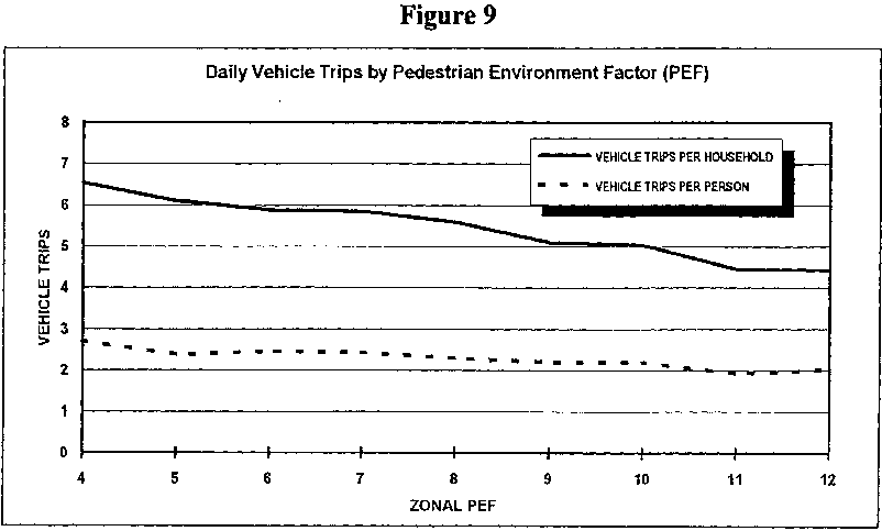
Even more interesting from Table 6 is that household vehicle trips and vehicle trips per person also decline with PEF. The more pedestrian friendly the area, the less auto trips households in that area tend to make. Moreover, the relative rates at which vehicle trip generation and VMT decline with PEF confirms that average trip distance also decreases as PEF values increase. Figure 9 illustrates the relationship between household vehicle trips and vehicle trips per person to the nine PEF values.
26 The Pedestrian Environment: Volume 4A
Household Travel Relationships
Figure 9
Click HERE for graphic.
The various relationships between land use patterns and household travel behavior examined above are all consistent with the conclusion that neighborhood (zonal) land use characteristics influence mode choice and vehicle trip generation. However, any pairwise relationship may indicate only a simple correlation, when in reality several land use, socio-economic and geographic factors act together in combination to influence household travel choices. The next section focuses on modeling these multiple factors together, to test the hypothesis that each factor individually and collectively does indeed influence automobile dependence.
The Pedestrian Environment: Volume 4A
27
Click HERE for graphic.
28
Modeling Household Vehicle Trip Choices
Modeling Household Vehicle Trip Choices
Two multiple linear regression models were constructed to explain how a variety of factors affect household travel behavior with the objective of either affirming or refuting the hypothesis that land use factors are important. Combinations of independent variables generally believed to explain the outcome of a dependent variable, in this case household vehicle trips and vehicle miles traveled, were analyzed in the development of the linear regression models. The models were designed to evaluate hypotheses regarding whether or not each "explanatory" variable, as well as all variables in concert, play a significant role in explaining travel behavior. An important model objective was the capability to isolate the effect of a single variable relative to the others. For example, land use patterns relating to pedestrian amenities, as measured by the PEF variable, have been hypothesized to impact transportation choices based upon observed correlations. However, the inclusion of other relevant variables such as income, employment status and location, makes it possible to control for their effects on people's transportation choices, thereby improving the interpretation of the impact attributed to the PEF. The "goodness of fit" or overall explanatory power of a regression model is measured in percentage terms by the adjusted coefficient of determination (TV). In general, the explanatory power of a model improves with the number of relevant independent variables, the quality of the data (in terms of the variability of each variable relative to the dependent variable) and the quantity of the data (in terms of the number independent observations of the dependent and independent variables). As is often the case with transportation models, some of the factors that influence household vehicle travel decisions are unobservable or unavailable, making it impossible to fully explain travel behavior. This is one reason for the relatively low R2 values in the two following models based on the Portland region dataset. The other principal cause for the relatively low overall explanatory power of the two models is a lack of variability or variation magnitude in key explanatory variables. Several of the variables are not individually household specific, thereby restricting the number and range of values. For example, values for the transit level-of-service to employment, pedestrian environment and household density variables are only available for the 384 internal zones in the Portland metropolitan area rather than values for each of the over 2,400 individual households. Likewise, income is available for each household, but its true variability is limited to eight distinct values from the income range choices on the home interview survey form. The limitations of this dataset impeded the ability to examine individual rather than household travel patterns and hindered the robustness of the model to explain household travel behavior. Despite these shortcomings, the dataset proved more than adequate for developing models for testing the relationships which are the subject of this report. The following subsections describe these two multiple regression models and their ramifications for household travel behavior.
The Pedestrian Environment: Volume 4A 29
Modeling Household Vehicle Trip Choices
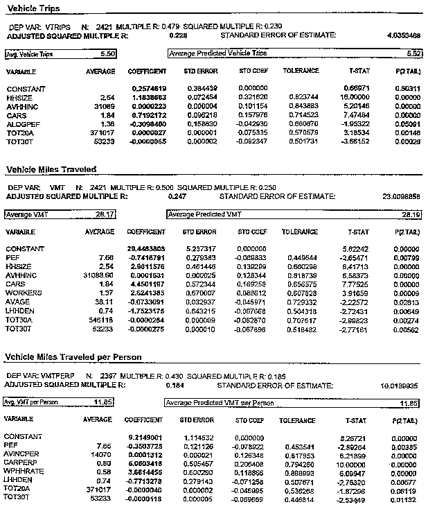
-- Vehicle Miles Traveled Model
A linear regression model was developed to explain how a series of variables contribute to the number of vehicle miles traveled by household members. The dependent variable, household VMT, reflects increases in vehicle usage from making additional trips and/or longer trips.7 During the model building process, several variables were rejected for one of two reasons:
1. Some variables, although expected to be useful model inputs, did not appear to be correlated with household VMT and/or vehicle trips, rendering it of little use in improving the model's fit with the data; or
2. The variable was highly correlated with another, better explanatory variable, a situation called multicollinearity, which precluded using both variables.
The latter case of multicollinearity occurs when two or more explanatory variables are highly correlated or approximately linearly related. For example, total employment within one mile of the zone centroid was a variable considered for both models. However, a significant correlation exists between this variable and the variable total employment accessible in 30 minutes or less via transit. When two such variables are approximately interrelated it becomes difficult to disentangle each variable's separate influence on travel behavior. If both are included in the same regression model, at least one of two coefficients cannot be estimated with sufficient precision or accuracy to be an acceptable component of the travel behavior model (i.e., the coefficient's standard error is so large that an acceptable confidence interval for the estimated coefficient is too wide to pin down the estimate as even differing from zero). For the above example, the employment accessibility variable proved singularly superior in its ability to help predict household VMT and vehicle trips than did the variable measuring employment within one mile of the zone centroid. Household size was included as a primary explanatory variable since it directly affects the number of vehicle trips, and therefore, miles traveled by a household. The number of workers in a household relative to the household size was also believed to contribute to VMT. Because the auto is considered a "normal good"(demand for its use increases with income), average household income was added to control for this expected relationship to VMT. Similarly, under the premise that not just income, but on-demand access to vehicles stimulates their use, the number of cars in possession by the household was also included.
_____________________
7.   Because the survey dataset does not include any information on
     ridesharing or vehicle occupancy, the household and per person
     VMT measures differ slightly from the measure of VMT per
     capita specified by the Oregon Transportation Rule.  In this
     report, VMT per person is measured by dividing household VMT
     by the average household size.  The Rule, on-the-other-hand,
     divides trip VMT into shares allocated to each person, for
     vehicle trips with more than one occupant For more information
     on the Oregon Transportation Planning Rule, see "Organ
     Transportation Planning Rule" Planning (March 1993) p. 13.
30 The Pedestrian Environment: Volume 4A
Modeling Household Vehicle Trip Choices
For the land use variables, different linear transformations of the PEF were investigated and a simple linear relationship was selected as providing the best model fit for explaining household VMT. The residential density of each household's zone was also included under the premise that higher density areas generally have land use patterns, including mixed uses, that better lend themselves to making pedestrian and transit trips.
Employment accessible within 30 minutes by both transit and auto were added to capture the transit level-of-service to employment, the viability of transit relative to the auto, and the geographic location of the household relative to major activity centers. It was expected that VMT would decline as auto accessibility improved, reflecting the travel distance component of accessibility, and also decline as transit level-of-service improved (transit travel times decreased), reflecting the improved viability of transit as an auto alternative.
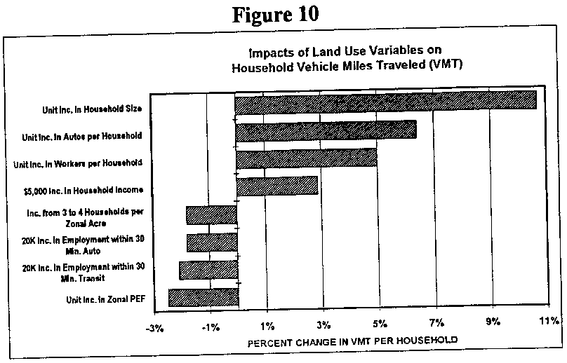
The combination of variables in this model explain 25 percent of the variation in household VMT. The remaining variation in household VMT captured by the model's constant term is attributable to factors not captured in the model, including type of household, household location decisions and trip purposes. Of the variables included, all had regression coefficients with the expected sign that were statistically significant.8 Likewise, the collective impact of all the variables together was also statistically significant.9 Table 7 and Figure 10 summarizes the predicted impact on household VMT for illustrative marginal changes in each of the explanatory variables.
                               Table 7
                Household VMT Model Predicted Impacts
                                                   IMPACT ON DAILY                                                  HOUSEHOLD VEHICLECHANGE IN EXPLANATORY VARIABLE                          TRIPS
Land Use Variables     Unit Increase in Zonal PEF                        -0.7 miles     Increase from 3 to 4 Households per Zonal Acre*   -0.5 miles     20,000 Increase in Employment Accessible by        Auto in 30 Minutes                              -0.5 miles     20,000 Increase in Employment Accessible by       Transit                                         -0.6 miles
Demographic Variables     $5,000 Increase in Household Income                0.8 miles     Unit Increase in Household Size                    3.0 miles     Unit Increase in Workers per Household             1.4 miles     Unit Increase in Cars per Household                1.8 miles
Average Daily VMT per Household                        28.2 miles

*    The household density impact on VMT is linear function of the
     natural logarithm of household density but is an exponential
     function of unit changes in household density; therefore, the
     VMT impact tapers off for unit increases in households per
     acre as household density increases.
For example, each unit increase in the PEF value lowers household VMT, on average, 2.5 percent. If sidewalk connectivity and street crossing improvements to the built environment
___________________________
8.   The t-statistic for the hypothesis test that a regression
     coefficient is significantly different from zero exceeded the
     critical value at the 0.05 level (95 percent confidence level)
     for each and every coefficient.
9.   The F-statistic for this hypothesis exceeded the critical
     value at the 0.05 level (95 percent confidence level).
The Pedestrian Environment: Volume 4A 31
Modeling Household Vehicle Trip Choices FIGURE 10
Click HERE for graphic.
of a zone could be accomplished to increase the PEF value two points, they could potentially decrease the annual VMT of households in that zone by 455 miles a year, or 182 vehicle miles per person. Over time, the effects may even be greater as the improvements in the pedestrian environment affect transit accessibility and household auto ownership rates. Table 8 presents the VMT model predicted impacts from a different perspective. It lists the approximate individual variable changes required to produce an equivalent reduction in VMT. Specifically, it lists the variable changes that would lower per person VMT 10percent for a household having all of the average characteristics for the sample, including the average size of 2.4 persons. In using these conclusions, the correlation between Zone I variables should be noted. See Appendix B.
                               Table 8
        Measures Which Reduce VMT Per Household 10 Percent10

--   Increase the quality of the pedestrian environment from
     average to high (four unit increase in PEF), or
--   Decrease the average number of cars per household by 1.5 cars,
     or
--   Increase household density from 2 to 10 or 3 to 15 households
     per zonal acre, or
--   Increase the number of jobs accessible by auto in 30 minutes
     by 105,000, or
--   Increase the number of jobs accessible by transit in 30
     minutes by 100,000.

________________________
10.  Approximate individual variable changes required to lower VMT
     per person by 10 percent for a household with average samples
     properties.
32 The Pedestrian Environment: Volume 4A
Modeling Household Vehicle Trip Choices
-- Vehicle Trip Generation Model
A second Bear regression model was developed to explain a household's propensity to make auto trips regardless of trip distance. As in the case of VMT, because the survey dataset does not include any information on ridesharing or vehicle occupancy, all trips made by household members age 5 and older as either an auto driver or passenger were considered individual vehicle trips. Variables for household size, average household income and household possession of cars were included in this model for the same reasons as in the VMT model. However, the household employment and residential density were discarded for not improving the explanatory fit of the model. Variables for the level of employment accessible within 20 minutes by auto and employment accessible within 30 minutes by transit were included to capture the transit level of service to employment, the viability of transit relative to the auto, and last, the geographic location of the household relative to major activity centers. In this case, it was expected that the number of vehicle trips would increase as auto accessibility or travel times to employment improved relative to transit (even though trip distances may be declining), and that vehicle trips would decrease as transit level-of-service improved and/or transit travel times decreased. A series of tests regarding the PEF indicated that household vehicle trip generation becomes increasingly sensitive to unit changes in the PEF value as that value increases. Consequently, a log-transformation of this variable provided the best "fit" to the model. Specifically, the natural log of the difference of the household zonal PEF less three was employed in the model to capture how the pedestrian environment affects travel choices. The resulting model explained 23 percent of the variation in the dependent variable, daily household vehicle trips. Moreover, the regression coefficient for every variable indicated the expected relationship (sign) with statistical significance and the collective impact of all the variable was also significant. Table9 indicates the impact on household vehicle trips predicted by the model for marginal changes in each of the explanatory variables.
The Pedestrian Environment: Volume 4A 33
Modeling Household Vehicle Trip Choices
                               Table 9
           Household Vehicle Trip Model Predicted Impacts
                                                   IMPACT ON DAILY                                                  HOUSEHOLD VEHICLECHANGE IN EXPLANATORY VARIABLE                          TRIPS

Land Use Variables     Increase Zonal PEF from 4 to 7
                    -0.4 trips
     Increase in Zonal PEF from 7 to 10*               -0.2 trips
     20,000 Increase in Employment Accessible by
       Auto in 20 miles                                 0.1 trips
     20,000 Increase in Employment Accessible by       -0.1 trips
Demographic Variables
     $5,000 Increase in Household Income                0.1 trips
     Unit Increase in Household Size                    1.2 trips
     Unit Increase in Cars per Household                0.7 trips
Average Daily Vehicle Trips per Household               5.5 trips*

     The zonal PEF impact on vehicle trips is a linear function of
     the natural logarithm of (PEF-3) but is an exponential
     function of the PEF value; therefore, the vehicle trip
     reduction impact of a unit change in PEF tapers off as
     increasingly higher PEF values are reached.
Based on this model, a three point increase in PEF from 7 to 10would decrease household vehicle trip generation by 65 trips per year or 26 vehicle trips per person, which is on average, a 3.6 percent reduction. Unit changes in PEF have the desired impact on household vehicle trip generation.
34 The Pedestrian Environment: Volume 4A
Conclusions
Conclusions
The research presented in this report makes the case that neighborhood (zonal) land use characteristics such as density, transit accessibility and a set of pedestrian environmental factors influence travel behavior in general and influence mode choice, vehicle trip generation, and trip length in particular. As a result, we can conclude that the land use characteristics of neighborhoods influence the number of vehicle miles traveled by households throughout the region.
Of the variables examined in this study, the set of variables known as "Pedestrian Environmental Factors" are the ones studied least to date. These factors include topography, ease of street crossings ,and street and sidewalk connectivity. Our research shows pedestrian amenities are present to a far smaller degree in the parts of the Portland region built after the Second World War and oriented to the automobile. It shows further that in the absence of these characteristics necessary to support pedestrian activity, transit patronage suffers and automobile use increases. The four factors identified as PEF's are easily identified and measured. However, they do not represent a taxonomy of attributes which support pedestrian activity. Rather they are indicators of a set of characteristics which must be present to support a successful transit and pedestrian oriented community or neighborhood. One measure of travel behavior chosen for most rigorous analysis is VMT (vehicle miles traveled). This measure, as noted, is a product of the number of vehicle trips per household multiplied by the average trip length. A multivariate regression has shown that the Pedestrian Environmental Factors are a statistically significant determinants of VMT and thus automobile use (auto dependence). This conclusion controls for the role of automobile ownership, household size, and household income on mode choice and travel behavior. Significantly, reductions in VMT are not only the result of shorter trip lengths, but also of fewer vehicle trips. Pedestrian Environmental Factors are a statistically significant contributor to this decline in vehicle trips. While the multivariate regression is not particularly robust in terms of the proportion of observed variation which it explains, we have suggested that this does not undermine the conclusions outlined above. In fact, the formulas used to model trip generation in this report are those widely accepted as appropriate for this purpose. They contain the number and kind of variables typically included in trip generation models at the city and metropolitan levels today. The inability of the regression to explain the majority of observed variation in vehicle miles of travel may be due, instead, to weaknesses in the data set itself which cannot be corrected in the context of this research.
The Pedestrian Environment: Volume 4A 35
Conclusions
One might argue that the phenomenon discussed here - evidence that the built environment influences travel behavior - is in part a result of a process of self selection, in which people disposed to travel by means other than autos select locations in which they may do this most easily. However, there is a growing body of evidence that there exists strong latent demand for the kinds of built environments required to reduce auto use.11 Further, there is little doubt that, absent these amenities, travel behavior would be further dependent on automobiles than it is today. Lastly, since the pedestrian friendly neighborhoods featured in this report have been in existence for up to a century, there should be little doubt about the cost effectiveness of such pedestrian oriented development patterns in terms of their benefit (reduced auto use, improved air quality) relative to their costs. In addition to demonstrating that the pedestrian environment affects auto dependence, the magnitude of the effect is also worthy of note. The impact of changes in the zonal pedestrian environment on daily household vehicle trips and vehicle miles traveled is similar in magnitude to the effect of other well recognized influences such as household age and employment accessibility. In summary, this research suggests the following conclusions:
1.   The adequacy of the pedestrian environment is a significant
     factor in explaining auto use, in combination with such
     socioeconomic measures as household income, size, number of
     workers, and auto ownership rates, and such land use variables
     as zonal density and accessibility.

2.   Travel demand and forecasting models across the United States
     can be enhanced by the inclusion of variables similar to those
     discussed above in their auto ownership, mode choice and
     destination choice models.  The ability of these models to
     explain observed variations in vehicle trip generation rates
     and trip lengths should be improved as a result.

3.   Unlike the other determinants of travel behavior, the
     characteristics of the built environment can be modified by
     public policies and investments.  Streets and intersections
     can be made more attractive to pedestrians.  Paths can be
     created into and through neighborhoods adjacent to arterials
     where transit service exists.  Thus there is a sound, rational
     basis for public policies in Oregon and across the United
     States which require patterns of neighborhood and urban
     development supportive of non-auto travel.


___________________________
11.  E.g., research by Anton Nelisen of Rutgers University and
     others.
36 The Pedestrian Environment: Volume 4A
Acknowledgments
Acknowledgments
-- About 1000 Friends of Oregon
1000 Friends of Oregon is a non-profit public service organization formed in 1975 to protect Oregon's quality of life through the conservation of farm and forest lands, the protection of natural and historic resources, and the promotion of more livable cities. The organization pursues these goals through research, public education, and legal action. 1000 Friends is supported by its membership and tax-deductible contributions.
1000 Friends Project Staff Keith A. Bartholomew Project Director Mary Kyle McCurdy Assistant Director -- Project Advisory Committees
"Making the Land Use, Transportation, Air Quality Connection" has been made possible, in part, by the contributions of time and expertise from the members of the study's three advisory committees.
National Technical Advisory Committee

Jeffrey M. Zupan, Chair
     Transportation Consultant, Chestnut Ridge, New York
George M. Crandall
     Principal, Fletcher, Farr, Ayotte, Portland, Oregon
Elizabeth Deakin
     Associate Professor, University of California at Berkeley
Frederick Ducca
     Federal Highway Administration, U.S. Department of
     Transportation, Washington, D.C.
The Pedestrian Environment: Volume 4A 37
Acknowledgments
Michael A. Replogle
     Transportation Project Co-Chair, Environmental Defense Fund,     Washington, D.C.
William Schroeer
     Energy Analyst, Air & Energy Policy Division, U.S.
     Environmental Protection Agency, Washington, D.C.

Policy Advisory Committee
Meeky Blizzard
     Sensible Transportation Options for People
William Blosser
     Chair, Oregon Land Conservation and Development Commission;
     Chair, State Agency Council on Growth in the Portland
     Metropolitan Area
Earl Blumenauer
     Commissioner, City of Portland
Rex Burkholder
     Bicycle Transportation Alliance
Jane Cease
     Administrator, Oregon Motor Vehicles Division
John Charles
     Executive Director, Oregon Environmental Council
Rena Cusma
     Executive Officer, Metro
James Gardner
     Councilor, Metro
Fred Hansen
     Director, Oregon Department of Environmental Quality
Michael Hollern
     Chair, Oregon Transportation Commission
Jim Howell
     President, Citizens for Better Transit, Inc.
Vera Katz
     Mayor, City of Portland
Patricia Kliewer
     Citizen Participation Organization #10, Washington County
Susan McLain
     Councilor, Metro
Gussie McRobert
     Mayor, City of Gresham
38 The Pedestrian Environment: Volume 4A
Acknowledgements
Linda Peters
     Commissioner, Washington County Board of Commissioners
John Russell
     President, Russell Development company
James Standring
     President, Westland Industries, Inc.
Thomas Walsh
     General Manager, Tri-County Metropolitan Transportation
     District of Oregonb

Local Technical Advisory Committee

G.B. Arrington
     Director of Long Range and Strategic Planning, Tri-County
     Metropolitan Transportation District of Oregon
Richard Bolen
     Regional Planning Supervisor, Metro
Robert Brannan
     Project Manager, Parsons, Brinckerhoff, Quade & Douglas, Inc.
Jon Chandler
     Home Builders Association of Metropolitan Portland
Robert Cortright
     Transportation Planner, Oregon Department of Land Conservation
     and Development
Andy Cotugno
     Planning Director, Metro
Brent Curtis
     Planning Manager, Washington County Department of Land Use and     Transportation
Steve Dotterer
     Chief Planner, Office of Transportation, City of Portland
Kenneth J. Ducker
     Director, Center for Urban Studies, Portland State University
Barrow Emerson
     Manager, Regional Rail Program, Office of Transportation, City
     of Portland
Brian Gregor
     Senior Transportation Planner, Oregon Department of
     Transportation
James N.P. Hendryx
     Planning Manager, City of Beaverton
Merlyn Hough
     Air Quality Division, Department of Environmental Quality
Keith Lawton
     Technical Manager, Metro
The Pedestrian Environment: Volume 4A 39
Acknowledgements
Doug McClain
     Principal Planner, Clackamas County
Scott Pemble
     Transportation Planning Supervisor, Multnomah County
Robin McArthur-Phillips
     Transportation/Land Use Planning Manager, Oregon Department of     TransportationSam Sadler
     Transportation Energy Specialist, Oregon Department of Energy
Ethan Seltzer
     Director, Institute for Portland Metropolitan Studies,
     Portland State University
Theodore Spence
     Consultant
Robert E. Stacey, Jr.
     Senior Policy Advisor, Office of the Governor
Ron Weinman
     Principal Transportation Planner, Clackwnas County
Mike Wert
     Transportation Development Manager, Oregon Department of
     Transportation
40 The Pedestrian Environment: Volume 4A
Acknowledgements
-- About the Authors of This Volume
Parsons Brinckerhoff Quade & Douglas, Inc.
Parsons Brinckerhoff Quade & Douglas, Inc. is the leading provider of transit planning and design services in the United States. The firm has been involved in more than 75 percent of the nations light rail transit systems in operation or under construction today. The firms architects have developed concepts for or designed over 200transit stations in the last ten years. Brent Baker, of the firm's Seattle office, is the principal author of this report. Samuel Seskin, Cathy Strombom and Youssef Dehghani contributed to the research.
The Pedestrian Environment: Volume 4A 41
Click HERE for graphic.
42
Appendix A
Portland PEF Scored By Zone
Pedestrian Environment Factor and Pedestrian Category by Portland Metropolitan Area Zone
Click HERE for graphic.
Appendix B
Results of Regression Analysis
     Correlation Coefficients (R-Values) between Zonal Variables
                                             Auto                              Household      by 30     Transit by                    PEF       Density        Minutes   30 MinutesPEF                 1.00 HouseholdDensity              .59        1.00
Auto by 30 Minutes           .41         .37           1.00
Transit by 30 Minutes           .64         .65            .45         1.00
Click HERE for graphic.