|
BACKGROUND
One definition of a visually attractive and unobtrusive highway is the
degree to which the horizontal and vertical alinements of the route have
been integrated into its surrounding natural and human environments. This
takes careful planning and design, as noted in the AASHTO Green Book:
Coordination of horizontal alinement and profile should not be
left to chance but should begin with preliminary design, during which
adjustments can readily be made ...The designer shouldstudy long,
continuous stretches of highway in both plan and profile and visualize
the whole in three dimensions.
This application of a holistic approach to highway design, where the
road is integrated into its surroundings, separates the outstanding
project from one that merely satisfies basic engineering design criteria
(see Figures 5.1 and 5.2). An excellent description of this holistic
design process is contained in the publication Aesthetics in
Transportation, from which the following is excerpted: A general rule
for designers is to achieve a "flowing" line, with a smooth and natural
appearance in the land, and a sensuous, rhythmic continuity for the
driver. This effect results from following the natural contours of the
land, using graceful and gradual horizontal and vertical transitions, and
relating the alinement to permanent features such as rivers or
mountains.
 |
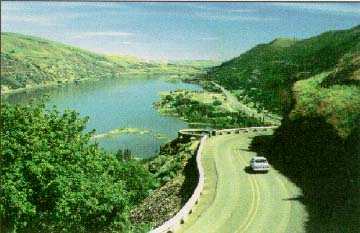
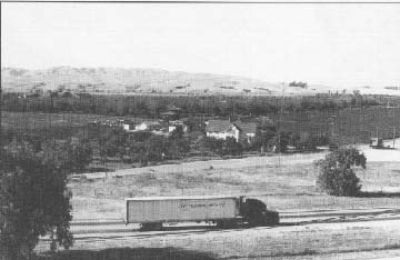
The alinement of Rt.8 gracefully follows the Naugatuck River.
(Naugatuck, CT) |
|
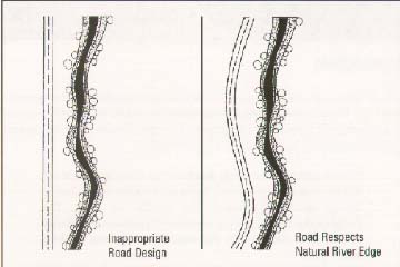
Figure 5.1
Inappropriate road design does not integrate with
the natural surroundings. 1 Aesthetics in Transportation,
U.S. DOT, November 1980, p. 89. |
 |
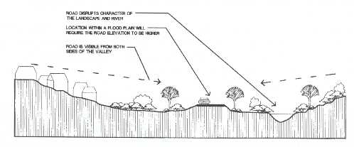 |
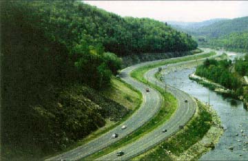
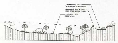
Figure 5.2
The alinement of a new facility plays an important role in
minimizing impacts on the surroundings. In this example, the
character of the landscape was disrupted.
|
|
In this alternative, the valley is undisturbed and
the road is partially shielded from view. |
 |
HORIZONTAL AND VERTICAL ALINEMENT CONSIDERATIONS
The greatest opportunities for influencing the horizontal and vertical
alinements of a highway occur during the planning and preliminary
engineering phases associated with a newlocation facility. The designs of
such facilities have the most dramatic effects on the natural and human
environments through which they pass.
|
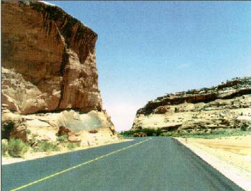
Preservation of unique rock formations enhances
the view along this highway. (State Route 313, Moab, UT) |
 |
The more typical design problem faced by today's highway engineers is
the improvement of an existing highway or street. In many
instances, the basic alinements may have been established well over 100
years ago. Regardless, the same basic design principles with respect to
horizontal and vertical alinements can, however, be applied to both new
and existing facilities.
Important points to consider regarding horizontal and vertical
alinements are that they should be consistent with the topography,
preserve developed properties along the road, and incorporate community
values. The superior alinements are ones that follow the natural contours
of the land and do not affect aesthetic, scenic, historic, and cultural
resources along the way. Construction costs may be reduced in many
instances when less earthwork is needed, and resources and development are
preserved. It is not always possible, however, to avoid having an impact
on both the natural and human environments. That is why the superior
alinements incorporate input received by the community through a
participatory design process.
When possible, the alinement should be designed to enhance attractive
scenic views, such as rivers, rock formations, parks, historic sites, and
outstanding buildings. The designation of certain highways as scenic
byways recognizes the importance of preserving such features along our
Nation's roadways.
Equally important as the consideration of the horizontal alinement is
that of the facility's vertical alinement. A number of factors influence
the vertical alinement of a highway, including the following:
- Natural terrain
- Minimum stopping sight distance for the selected design speed
- The number of trucks and other heavy vehicles in the traffic stream
- The basic roadway crosssection; i.e., two lanes versus multiple
lanes
- Natural environmental factors, such as wetlands and historic,
cultural, and community resources
COMBINATION OF HORIZONTAL AND VERTICAL ALINEMENT
The interrelationship of horizontal and vertical alinement is best
addressed in the route location and preliminary design phases of a
project. At this stage, appropriate tradeoffs and balances between design
speed and the character of the roadtraffic volume, topography, and
existing developmentcan be made. A mistake often made by inexperienced
engineers is designing the horizontal alinement first and then trying to
superimpose the design onto a vertical profile. Because they must be
complementary, horizontal and vertical geometries must be designed
concurrently. Uncoordinated horizontal and vertical geometries can ruin
the best parts and accentuate the weak points of each element. Excellence
in the combination of their designs increases efficiency, and safety,
encourages uniform speed, and improves appearancealmost always without
additional cost.
One tool to assist in coordinating horizontal and vertical geometries
is the use of computeraided design (CAD). CAD enables highway designers to
quickly assess the interrelationships between horizontal and vertical
alinement, particularly in areas of difficult terrain.
Proper consideration of these basic design considerations will help to
ensure that both newlocation facilities and improvements to existing
highways fit harmoniously into their surroundings.
|
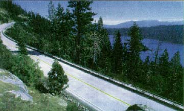
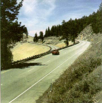
Good integration of horizontal
andvertical alinement on a reconstructed twolane rural
highway.
(State Route 89 near Lake Tahoe, CA) |
 |
ISSUES
There are numerous examples around this country of excellence in
integration of the horizontal and vertical alinements of highways into
their surroundings. Unfortunately, there are also examples of new or
widened highways that have scarred a rural landscape or disrupted an
established community. While these past actions cannot easily or
inexpensively be rectified, future problems can be avoided by applying the
principles outlined above and the creative approaches detailed below.
Avoiding Impact on Adjacent Natural and Human Environments
Particularly during the era of Interstate construction from the 1950's
to the 1980's, a number of instances of new highway construction had a
devastating impact on communities and areas of environmental sensitivity.
It is readily acknowledged that there will be some degree of physical
impact on the surroundings associated with the construction of any new
location highway or major reconstruction or widening of an existing
highway facility. However, from the perspective of horizontal and vertical
alinement, much of this impact can and should be alleviated.
Solution
Impact on the surrounding environment can be minimized by careful
attention to detail during the route location and preliminary design
phases and a willingness of all concerned parties to work together toward
a common goal. For example, minor adjustments to the originally proposed
horizontal and vertical alinements (combined with the use of short
sections of retaining wall) along the Lincoln Beach Parkway (U.S. Route
101) in Oregon eliminated the need to acquire any of the adjacent homes
and businesses.
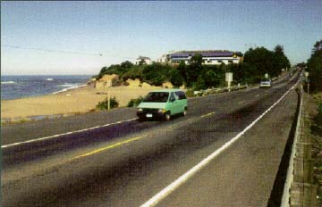
|
Minor alinement changes can avoid impacts on
adjacent properties. (U.S. Route 101, Lincoln Co., OR) |
 |
Similarly, a minor horizontal alinement shift at the beginning of the
project allowed for the Hollister Bypass (SR 156) in San Benito County,
CA, to avoid affecting a number of historic properties.
 |
Impact on the historic Mitchell Fruit Farm was avoided as a
result of a minor shift in the horizontal alinement of the Hollister
Bypass.
(San Benito, CA) |
The use of a "cutandcover" design, whereby the roadway is placed below
the existing ground level and covered over with a park, building, or other
public space can help to avoid negative impact. Lake Place Park in Duluth,
MN and other public parks were the result of cutandcover tunnels that not
only saved historic properties but also gave pedestrians improved access
to Lake Superior.
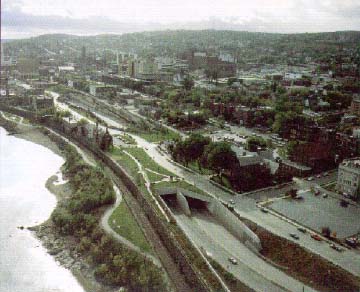
|
Designers employed several cutandcover tunnels
along I35 to avoid impacting an historic district and to reconnect
the downtown to the waterfront.
(Duluth, MN) |
 |
In many cases, there is a potential for designing a divided highway
with independent horizontal and vertical alinements for each direction of
traffic.
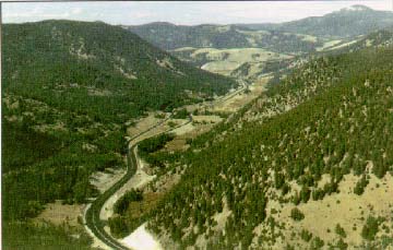
 |
Separate profiles and varied median widths on divided roadways
are options for designers to minimize impact on the environment.
(Rt 395, Inyo National Forest, CA) |
|
Each side of the highway can have a different
alinement to better integrate the roadway into its surroundings.
(I15, MT) |
 |
Coordination Between Horizontal and Vertical Alinement
When horizontal and vertical alinements are designed separately from
one another, unnecessarily large cuts and fills may be required, resulting
in very dramatic and often visually undesirable changes to the natural
landscape.
Solution
One of the ways to ensure the most effective coordination of horizontal
and vertical alinement is through the use of a multidisciplinary design
team during the planning and engineering phases of a project. On such
projects as 166 in Fairfax and Arlington Counties in Virginia, the
combined expertise of landscape architects, urban designers, structural
engineers, and historic preservationists, in addition to civil engineers
and highway designers, has resulted in superior highway improvement
projects.
The concept of using a multidisciplinary design team is not new; it was
pioneered in the early 1900's during the planning and design of the Bronx
River Parkway in Westchester County, NY After a period of use primarily on
largescale or controversial projects, this approach has come back into
more general application as a way to achieve community consensus.
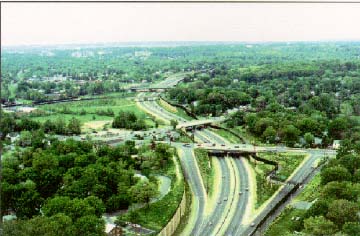
|
A multidisciplinary design team can help minimize
the impact an urban freeway has on a community.
(I66, VA) |
 | |