|
BACKGROUND/PURPOSE
When the 121kmlong (75mile) Columbia River Highway between Troutdale
and The Danes was officially completed on June 27, 1922, it was hailed as
one of the engineering marvels of its age. The first paved highway in the
Northwestern United States, the Columbia River Highway was conceived,
designed, and constructed as both a scenic attraction and as a means of
facilitating economic development along the Columbia River corridor
between the Pacific Ocean and the areas to the east of the Cascade
Mountains. It was heralded as one of the greatest engineering feats of its
day, not only for its technological accomplishments but also for its
sensitivity to one of the most dramatic and diverse landscapes on the
North American Continent.
 |
 |
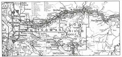
| Location site map |
The history of the development, decline, and continuing rebirth of the
Columbia River Highway is particularly instructive to the highway
engineering community as we approach the beginning of a new century and a
future of increasing reliance on the rehabilitation and restoration of
existing infrastructure instead of the construction of new highways. This
study also illustrates the manner in which state and local governments can
preserve and enhance existing highways that possess unique scenic and
historic qualities within the framework of modern design criteria. Much of
the discussion of the background and history of the highway has been
excerpted from the Historic Preservation League of Oregon's publication
Oregon Routes of ExplorationDiscover the Historic Columbia River
Highway' and A Traveler's Guide to the Historic Columbia River
Highway.'
Creation of the Columbia River Highway
Samuel C. Lancaster was the designer of the Columbia River Highway. His
romantic and deeply spiritual attitudes toward the environment and
mankind's relationship to nature framed subsequent discussions of the
Historic Columbia River Highway for all time. Looking back from the
vantage point of 80 years after its dedication, one cannot help but marvel
at how well Sam Lancaster accomplished his task. Highway building in the
United States was in its infancy. The automobile had not yet become the
dominant mode of transportation that it is today. The human foot, the
horse and wagon, the riverboat, and the railroads were the means of
popular transportation.
Travel conditions before the highway was built were grim. What roads
existed were crude and unstable dirt wagon trails. Pioneers trying to get
to the Willamette Valley from The Dalles during the early 1800's had
essentially three choices: (1) build a raft and risk the dangers of the
rapids near Cascade Locks, (2) pick their way along the Columbia River
Gorge, where they encountered mudflows, rockslides, canyons, and sheer
rock walls, or (3) follow the Barlow Trail over the southern flank of Mt.
Hood. Each of these routes was hazardous and slow. Oregon Routes of
Exploration Discover the Historic Columbia River Highway, Historic
Preservation League of Oregon, PO. Box 40053, Portland, OR 97240. `A
Traveler's Guide to the Historic Columbia River Highway, M&A Tour
Books, 3951 SE El Camino Drive, Gresham, OR 97080.
By the late 1800's, steamboats and railroads served some locations
along the Columbia Gorge, but a good road was needed for general traffic.
Early roadbuilding efforts, such as the Wagon Road from the Sandy River to
The Danes of the 1870's, were largely unsuccessful. Serious attention to
building a road through the Columbia Gorge grew with the advent of the
automobile. In 1908, Samuel C. Hill, often referred to as the "Father of
the Columbia River Highway" and a Good Roads Advocate in Washington and
Oregon, invited Sam Lancaster, already known for his pioneering
roadbuilding efforts in Tennessee, to the Pacific Northwest to share in
Hill's vision of creating a highway through the Columbia Gorge. In 1908,
Hill, Lancaster, and Major H.L. Bowlby (who was soon to become the Oregon
State Highway Department's first State Highway Engineer) traveled to
Europe to attend the First International Roads Conference. They traveled
extensively in Germany, Italy, and Switzerland to view and study European
roadbuilding techniques and designs.
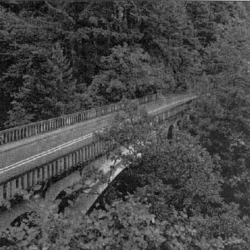
|
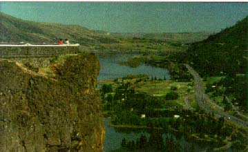
Typical overlook area along the
highway. |
 |
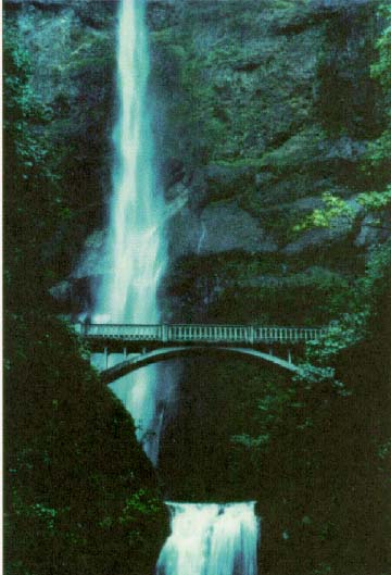 |
One of the many waterfalls along the route.
|
The Vision Becomes a Reality
Upon their return from Europe, Hill and Lancaster began designing and
building a prototype paved road system on the grounds of Hill's 28.3km
(7,000acre) estate at Maryhill, WA. In February 1913, the Oregon State
Legislature viewed the results of this effort and went away sufficiently
impressed to create the Oregon State Highway Department and Commission the
next month. Major H.L. Bowlby was subsequently appointed the first State
Highway Engineer; later Sam Lancaster was named Assistant State Highway
Engineer and Charles Purcell was named State Bridge Engineer.
On August 27, 1913, the Multnomah County Commissioners met
with Hill and the backers of the highway project at the Chanticleer Inn
overlooking the western end of the Gorge. The next day, Sam Lancaster,
attending as a guest of Hill's, was appointed Multnomah County Engineer
for the highway. (One year later the Columbia River Highway was designated
a State highway, setting the stage for future State involvement.)
Lancaster went to work immediately, beginning the survey and route
location from Chanticleer Point to Multnomah Falls in September 1913.
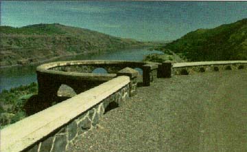
|
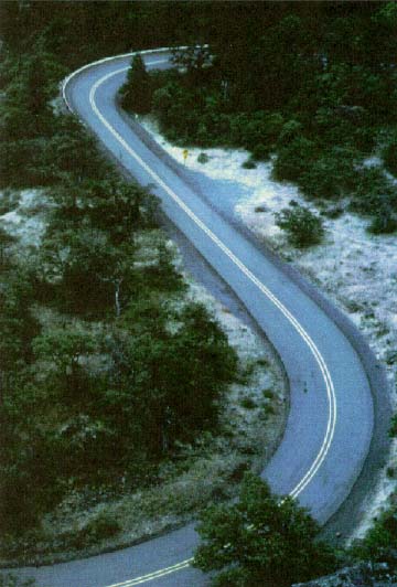
Typical curvilinear alinement |
 |
From the very beginning, this was to be both a scenic and a modern
highway. The challenging requirements set by Lancaster were to locate the
road in such a way that it would be at least 7.3 m (24 ft) wide, have
grades no steeper than 5 percent, and have curve radii no less than 30.5 m
(100 ft). At the same time, the roadway was to be located so as to provide
maximum scenic opportunities, yet do as little damage to the natural
environment as possible. Amazingly, Lancaster was able to achieve all
these goals, even over the first segment of the highway, which required
accomplishing an elevation change of nearly 183 m (600 ft) in a distance
of less than 1.6 km (1 mile).
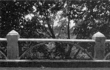
The construction of the highway incorporated a number of features then
found only in Europe such as miles of dry masonry walls (built by Italian
stone masons) and rock rubble guard walls with arched openings. At
Mitchell Point, John Elliott, the location engineer who worked with
Lancaster on the eastern segment of the highway, exceeded the achievements
of the legendary Axenstrasse around Lake Lucerne, Switzerland. Elliott
directed the construction of a tunnel bored through solid rock into which
were cut five openings instead of the three on the Axenstrasse, to allow
travelers to view the magnificent scenery. An original design element was
the construction of stone observation areas with benches for weary
travelers. Extensive use was made of the thennew construction material
reinforced concrete for bridges and viaducts, over the length of the
highway. Many of these structures are still in use today.
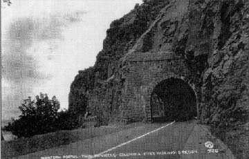
|
Early days of the Columbia River Highway.
|
 |
The highway, although only partially paved, was officially opened on
July 6, 1915, between Portland and Hood River. Paving began in June 1915,
making the Columbia River Highway the first major paved road in the
Northwest. On June 7, 1916, the highway was officially dedicated with
ceremonies at Crown Point and Multnomah Falls. At 5:00 p.m. that day,
President Woodrow Wilson touched a button in the White House that
"electronically unfurled the flag of freedom to the breezes" at Crown
Point.
Construction continued eastward from Hood River along the alinement
established by John Elliot in 1915 to The Danes. This final section of the
highway included two tunnels bored through the bluffs near Mosier.
Finally, on June 27, 1922, Simon Benson, who was an ardent supporter and
benefactor of the project, ceremoniously spread pavement mixture on the
final segment at Rowena Point near The Dalles. After almost 9 years of
work on the Columbia River Gorge Highway, the final segment linking
Astoria to The Dalles was complete. From The Dalles to Troutdale, workers
had built an amazing 119 km (73.8 miles) of roadway, including 3 tunnels,
18 bridges (some of worldclass quality for their time), 7 viaducts, and 2
footbridges.
Early Economic Benefits of the Highway
The Columbia River Highway proved to be much more than just an
engineering marvel and a scenic attraction. It stimulated tremendous
economic growth in every community it touched. Restaurants served up
salmon and chicken dinners to hungry travelers. Automobile dealers and
service stations sprang up to fix tires and replenish fuel. Before long,
motor parks, auto camps, and the grand Columbia Gorge Hotel in Hood River
made it possible for travelers to experience a variety of overnight
accommodations. Retail stores flourished in the towns along the route, and
summer homes appeared on the forested slopes above the river and the
highway.
Decline and Disuse
Within a decade after its completion, technological advances in
transportation began to make the Columbia River Highway obsolete. Trucks
and cars became larger and faster, making travel on the narrow, winding
roadbed increasingly difficult and dangerous. By 1931, plans were underway
to make another road, but this one would be straighter and closer to river
level. Public enthusiasm for this replacement highway was tempered by a
lack of funds and, aside from a new tunnel constructed through Tooth Rock
near Bonneville Dam in 1935, little more was done. Nevertheless, interest
in the new highway remained high, and a portion of it was constructed from
Troutdale to Dodson in the summer of 1949.
By 1954, the new "waterlevel" freeway (originally designated as U.S.
Route 30 but now I84) finally reached The Dalles, but not without
significant damage to the original Columbia River Highway. Nearly 4.2 km
(26 miles) of the old road between Dodson and Hood River had been either
destroyed or abandoned. In 1966, the worldfamous Mitchell Tunnel was
dynamited to allow for the completion of the adjacent section of I84. Many
of the original bridges, stone guardrails, and observatories fell into
disrepair. Towns and businesses bypassed by the freeway suffered declines
as new economic opportunities were created at the freeway interchanges.
The only segments of the original route that remained usable were the
sections from Mosier to The Dalles and from Dodson to Troutdale. The
Historic Columbia River Highway began to deteriorate badly.
Renewal and Rebirth
Fortunately, the 1980's marked the reversal of this trend. Heightened
environmental awareness led to the creation of the Friends of the Gorge,
which spearheaded the successful effort to create the Columbia River Gorge
National Scenic Area. The preservation and interpretation of the historic
highway is specifically mandated in the Federal enabling legislation,
which also created the Bistate Columbia River Gorge Commission.
A parallel historic preservation movement led to a survey and inventory
of the historic highway by the National Park Service. In 1983, the Oregon
DOT successfully nominated the surviving sections of the Historic Columbia
River Highway to the National Register of Historic Places. The Historic
Preservation League of Oregon led the successful effort to create the
Historic Columbia River Highway Advisory Committee to monitor changes,
alterations, and improvements to the highway.
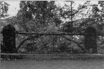
|
Early days of the Columbia River
Highway. |
 |
 |
After restoration. |
Signs of the rebirth of the great road are everywhere. The Oregon DOT
is doing an excellent job of rebuilding stone guardrails and concrete
caps, recasting and installing delicate concrete arches along the
viaducts, and signing the highway with an appropriate logo. The Highway
Division of the Oregon DOT is also in the process of developing a longterm
master plan for the restoration and reuse of the highway. The Friends of
Vista House, in cooperation with the Oregon State Parks and Recreation
Department, have restored the Vista House as an interpretive center.
Today, millions of visitors each year drive, hike, and bicycle along
portions of the highway.
ENVIRONMENTAL AND DESIGN ISSUES
AND CONSTRAINTS
|
Perhaps the single most distinguishing feature of the ongoing
efforts to rehabilitate the Historic Columbia River Highway is that
the designs are intended to replicate the original configuration of
the facility as it existed at the time of its completion in 1922.
This is analogous to the historic preservation process applied to
buildings to return them to their original conditions. Current
Oregon DOT plans call for the restoration of as much as possible of
the entire 119 km (74 miles) from Troutdale to The Dalles as either
a scenic highway or a hiker/biker trail.
The location of the highway in a National Scenic Area prevents
the construction of any projects that would have an adverse impact
on the defined historic resource, which in this instance is the
highway itself. |
 |
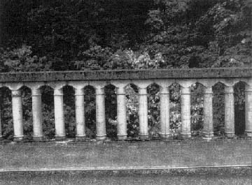
ACTIONS TAKEN TO RESOLVE ISSUES
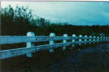
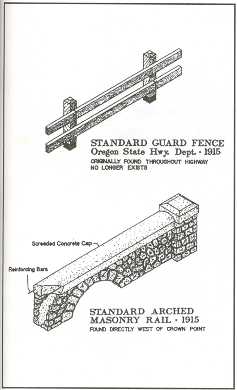
CrashTested Historic Guardrails
One of the more impressive ongoing restoration projects involves the
replacement of existing steel guardrails installed over the past several
decades with a "new" crashtested twobeam timber guardrail backed by wood
and steel that closely replicates the original 1915vintage guardrail
design, of which no sections remain today. The "new" guardrail has been
crash tested at 80 kph (50 mph) and approved for use by the FHWA
nationwide. Interestingly, evidence in the archives of the Oregon DOT
indicates that the original 1915 guardrail design was adopted by the U.S.
Bureau of Public Roads and several States in the 1920's and 1930's as the
"standard" guardrail for use in similar rural environments.
Oregon DOT staff noted that, if current AASHTO guidelines were to be
fully adhered to, the historically accurate replacement guardrail would
need to be installed at many more locations than where it previously
existed and it is currently being reinstalled.
Hiker/Biker Multiuse Design Elements
In places where it would not be economically feasible to recreate the
historic road in its original location, a representative hiker/biker trail
is planned for construction. In such areas as the nowclosed Mosier
Tunnels, which are too narrow to accommodate two travel lanes wide enough
for modern vehicles, the rubblefilled tunnels will be rehabilitated to
their original conditions and will provide access limited to bicycles and
pedestrians. Wherever possible, the "new" sections of facility needed to
accommodate the current "missing links" in the original 1920's vintage
alignment will utilize the same historical design criteria of maximum 5
percent grades and 30.5mminimum (100ft) radius curves, although a slightly
narrower pavement width may have to be provided in certain locations. The
new hiker/biker trails are being designed in accordance with current ADA
provisions in order to allow use of these facilities by individuals with
disabilities.
|
Newly installed steelbacked wooden guardrail.
|
 |
Aesthetic Considerations of Enhancement Projects
 |
Throughout the design of the current enhancement/rehabilitation
projects, Oregon DOT staff members have been particularly cognizant
of the need to consider the aesthetic qualities of the Columbia
River Gorge. An example of this concern is the manner in which the
remediation of a continuing rock fall area was addressed as part of
the rehabilitation project encompassing Tanners Creek to Eagle
Creek. Because it was not possible to use Oregon DOT's standard
steelcolumnsupported, metal rockfall fencing, the decision was made
to shift the roadway alignment slightly to provide a greater
separation between the rock face and the edge of the travelway. The
resulting lateral separation space is able to accommodate falling
rocks.
Moreover, because virtually the entire length of the Historic
Columbia River Highway is on the National Register of Historic
Places and the highway is located in a designated National Scenic
Area, no roadway widenings are permitted. The result is that the
"new" roadways are identical in cross section to the existing
highway.
In the Tanners Creek area, the planned improvements will involve
the removal and relocation of existing overhead electrical utility
lines and poles and the removal of some trees to reopen some of the
historic vistas of the gorge. One issue to be addressed here is
determining exactly which of the trees should be removed.
|
Cost Considerations of Historic Enhancement Projects
The costs of the ongoing rehabilitation and enhancement projects for
the Historic Columbia River Highway are considerable. For example, the
initial installation of 886 m (2,906 linear ft) of tworail steelbacked
timber guardrail had a total bid price of $119,146 or about $41.00 per
linear ft ($134.50 / m). If standard Oregon DOT steel guardrail had been
installed, the estimated cost would have been approximately $32,000 or
about $11.00/linear ft ($36.09/m). The historically accurate timber
guardrail costs about 31/2 times as much to install as traditional steel
guardrail. Since the installation of the initial sections of the tworail
steelbacked timber guardrail in 1992, however, no maintenance of the
guardrail has been necessary. It is anticipated that the guardrail will
eventually need to be repainted about once every 5 years. The estimated
cost of this activity (in 1994 dollars) is approximately $3.20/linear ft
($10.50/m).
Similarly, the requirement for the use of hand labor in association
with the reconstruction of stone guard walls has resulted in substantially
higher costs for this activity than if standard steel guardrails or
concrete barrier walls had been installed. However, the Oregon DOT
understands the need for an appropriate balance to be maintained between
enhancement, maintenance, rehabilitation, and new construction projects
and remains committed to the Historic Columbia River Highway projects.
LESSONS LEARNED
The experience of the Oregon DOT with the design and construction of
improvements to the Historic Columbia River Highway has the potential for
widespread application across much of the United States. In particular,
many of the generally lowvolume rural highways that have been, or are
proposed to be, designated as "scenic highways" date from the general era
of the original Columbia River Highway and thus share similar geometric
constraints. Now that regional through traffic that once used these older
highways has shifted to more modern parallel freeway routes, opportunities
may exist for the enhancement and rehabilitation of these older routes to
a configuration similar to that at the time of their original
construction.
The existence of an FHWAapproved tworail steelbacked timber guardrail
that has been crash tested to 80 kph (50 mph) provides an alternative to
the use of current steel guardrail designs, especially on those routes
where the timber guardrail would help to provide a more aesthetically
pleasing vista. Finally, the experience of the Oregon DOT with the
construction and maintenance of such "nontraditional" roadway design
features as timber guardrails and stone guard walls should prove to be of
use to a number of other States facing similar requests from historic
preservation groups.
 |
Young's Creek (Shepards Dell) Bridge after
restoration. |
|
Spindle railing after restoration on the Young's
Creek Bridge. |
 |
|
HISTORIC COLUMBIA RIVER HIGHWAY
AT A
GLANCE |
| Setting: |
World-class designated National Scenic Area; rural highway
passing through small communities. |
| Length: |
Approximately 119 km (74 miles) (from Troutdale to
The
Dalles) |
| Traffic Volume: |
Widely variable, from approximately 4,200 vehicles per day
in most heavily traveled western sections (with peak summer
weekend volumes of approximately 7 ,500 vehicles per day) to
about 500 vehicles per day in the most lightly traveled
eastern sections |
| Design Speed: |
Not applicable; rehabilitation of existing historic
roadway; esti mated design speed of 56 to 73 kph (35 to 45
mph) |
| Type of Road: |
Historic, scenic highway (owned and maintained by Oregon
DOT); functional classification -collector |
| Design Cost: |
Current enhancement/rehabilitation projects only-
Not
available (in-house by Oregon DOT staff) |
| Construction Costs: |
Current enhancement/rehabilitation projects
only-
$120,000 for initial installation of 886 m (2,906
linear ft) two-rail steel-backed timber guardrail; $35,000 for
initial rock guard wall reconstruction; other projects
totaling approximately $4.0 million are planned for the next 3
to 5 years |
| Key Design Features:
|
Restoration/rehabilitation of existing historic highway to
original condition at time of completion in 1922; installation
of two-rail steel-backed timber guardrail very similar in
design to original; reconstruction of rock guard walls;
reconstruction of original concrete bridges |
| Debits: |
Design limits operating speeds to 48 to 65 kph (30 to 40
mph) in most areas |
| Similar Projects: |
Paris-lexington Road, KY
Oyster River Bridge, Durham,
NH
SR 89, Emerald Bay, lake Tahoe, CA
SR 92, lebanon
Road, New Castle County, DE |
Contacts for Additional
Information: |
Ms. Jeannette Kloos
Scenic Area Coordinator
Region
I
Oregon Department of Transportation
123 NW
Flanders
Portland, OR 97209-4037
Tel:
503-731-8234
Fax: 503-731-8259
Mr. Dwight A. Smith
Cultural Resource
Specialist
Technical Services Branch
Oregon Department
of Transportation
1158 Chemeketa Street, N.E.
Salem, OR
97310
Tel: 503-986-3518
Fax:
503-986-3524 | | |