| Environment |
|
|
|
|
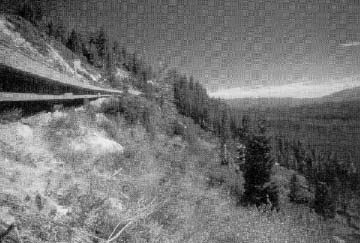
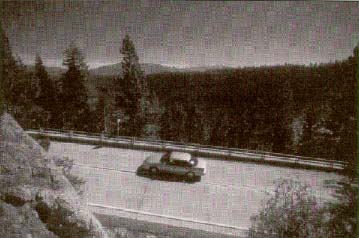
View from top of slope beyond to Lake Tahoe |
STATE ROUTE 89-EMERALD BAYSOUTH LAKE TAHOEEl Dorado County, CA |
 |
|
BACKGROUND/PURPOSE This project is located on the east side of the Sierra Nevada mountain range in northwestern California very close to the Nevada State line. Construction involved a 1.1km (.7mile) stretch of State Route 89 along Emerald Bay near Cascade Lake and Eagle Falls on the southwestern shore of Lake Tahoe. The purpose of this project was to upgrade a stretch of the existing narrow twolane section of Route 89 to a more modern twolane cross section. The primary goal of the proposed design was to address slope stabilization and erosion control issues to reduce rock slides that frequently closed this section of the highway,
which is the only allweather route around the west side of Lake Tahoe. Secondary goals of the project were to improve safety, enhance roadway drainage, and minimize potential negative impact on the water quality of Lake Tahoe.
ENVIRONMENTAL AND DESIGN ISSUES AND CONSTRAINTS The physical location of the project, combined with the climatic conditions of the region, presented a number of unusual issues and constraints that had to be addressed during the design and construction phases of the improvement. Unstable Geology The area adjacent to the western side of Lake Tahoe is subject to relatively frequent earthquakeinduced landslides and rock falls. The basic geological structure of the area is fractured granite with steep slopes and little ground cover. Indeed, the primary rationale for the project was the desire to alleviate continuing slope instability problems.
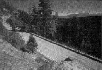
Limited Construction Season This section of State Route 89 is closed during the winter months (typically from midNovember through the end of February) because of continuing major snowfall accumulations that make plowing impractical. Moreover, with several sections of the route lacking shoulders or guardrails, allowing motorists to use the facility, even if adequate snow removal could be provided, would not be advisable. The route is, however, subject to heavy tourist use in the summer and early fall months, and a significant percentage of the traffic is motor homes and buses. These factors combined to limit the available construction period to the spring and late fall months of the year. Additional time constraint problems arose, because the road had to be totally closed for a period of approximately 6 weeks for blasting, boulder removal, and major earthwork. The Tahoe Regional Planning Agency A major issue associated with the project was the requirement to maintain the unique visual characteristics of the project area. This task is, in part, the responsibility of the Tahoe Regional Planning Agency (TRPA), a congressionally mandated bistate (Nevada/California) agency that is organized to maintain and enhance the scenic and aesthetic qualities of the Lake Tahoe region. Some areas within the project limits were identified as TRPA Stream Environment Zones that drained directly into Lake Tahoe. About 0.09 ha (.22 acres) of these zones would be disturbed during the project. ACTIONS TAKEN TO RESOLVE ISSUES Roadway Design Elements In order to relieve the rock slide problems that had necessitated the project, the back slope angles were reduced and a number of the largest granite boulders were removed. Slope netting was used in some locations to provide stability until vegetation could be established. Doublethickness retaining walls, terraced rock catchment walls, and trenches were used over the length of the project to provide additional protection areas between the problem slopes and the improved roadway. In locations with the most significant rock slide potential, sidehill viaduct roadway sections were constructed to carry one lane of traffic and a narrow shoulder. The use of these viaducts essentially shifted the horizontal alinement of the travelway by a distance of one travel lane eastward toward the lake shore and away from the problem slopes. The final "asbuilt" section includes two 3.6m (12ft) travel lanes and two 0.6m (2ft) shoulders. The only design exception required was for allowance of the 0.6mwide
(2ft) shoulders. FHWA and AASHTO generally consider a 1.2mwide (4ft)
shoulder as the minimum acceptable width for a twolane major
collector/minor arterial roadway, such as this portion of State Route 89.
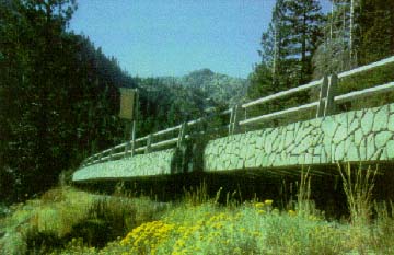
Safety along the route was improved with the addition of the two 0.6m (2ft) shoulders and the 3.6m (12ft) travel lanes. This resulted in a total travelway width of 8.5 m (28 ft), which was in context to the previous 6.7m (22ft) travelway that lacked any effective shoulder area. In an effort to achieve a 65 kph (40 mph) stopping sight distance and improve an existing "blind" curve, a compound curve with a radius of 152 m to 305 m (500 ft to 1,000 ft) was replaced with a single 457 m (1,500 ft). Road Closure Disincentives In order to keep the period of road closure to a minimum, the contractor was provided with an incentive/disincentive clause in the contract of $50,000 per day. The contractor closed the road for 6 weeks starting May 1, 1992, and through the use of 24hour construction during that time, earned a $400,000 bonus. After the 6week period of total closure, alternating oneway traffic was used to keep the road open. Construction on the project began on April 12, 1992, and was completed 18 months later. The bid was awarded for $7.6 million, although the final construction cost rose to approximately $9.2 million as a result of unforseen difficulties with rock excavation and slope stabilization. Aesthetic and Environmental Improvements When the project was originally constructed in 193031, extensive use was made of stone masonry walls. Several sections of these walls needed to be replaced during the new project. In an effort to maintain the high level of aesthetic quality in the region, the new sidehill viaduct retaining walls were constructed with textured forms to replicate the surface of the original stone walls. The textured wall forms were constructed in 3.7m by 3.7m (12ft by 12ft) sections to minimize the number of splice locations. It is anticipated that some of the structures will eventually be hidden by vegetation. The TRPA initially determined that the color selected for the textured wall forms of the sidehill viaduct retaining walls was too dark and needed to be lightened to better match the existing granite of the region. The original wall stones that were removed were reused to construct walls in a parking area at the Eagle Falls overlook area. One of the more interesting changes made to the original Caltrans design was the replacement of the standard solid concrete lakeside parapet barrier with a more aesthetically pleasing twobeam guardrail mounted on a low concrete barrier. The new barrier design allows for a better view of the lake from both lanes of traffic and is essentially invisible from the lake and its shoreline. Although the original barrier design proposed by Caltrans was the generally accepted statewide standard for such applications, it was considered to be unacceptable by the TRPA. The twobeam guardrail which was finally installed had been crash tested by FHWA some years earlier but had not, at the time of this project, been adopted by Caltrans as an acceptable guardrail type. Subsequent to this project, the twobeam guardrail design was accepted by Caltrans as a standard design, particularly in areas with similar aesthetic considerations.
Some 1,800 trees and shrubs were planted between the terraced upper slope walls and behind the rock catchment walls to blend the slope stabilization treatment into the existing natural environment. The contractor maintained a 1year plant establishment period, which was supplemented by a Caltrans care and replacement program for four growing seasons. The 0.09 ha (.22 acres) of Stream Environment Zone that were disturbed by the project were revegetated with the same type of plant species. The species were identified on a joint field review by the Caltrans Resident Engineer and representatives from the United States Forest Service and the California Department of Parks and Recreation. Stream patterns within the Stream Environment Zone were not altered. LESSONS LEARNED The Emerald Bay project is an example of a road improvement project with potential widespread applicability across the Nation. This is particularly true, because the work involved the reconstruction of an existing twolane facility dating from the 1930's. The roadway is also located in an area where accommodating environmental and aesthetic considerations was viewed as a primary goal of the project, on an equal footing with improving traveler safety. The result was an improved road with a very scenic character. However, this result was achieved at a relatively high cost of $9.2 million for 1.1 km (.7 miles) of roadway. A somewhat nontraditional review agency, the TRPA, played a major role in defining the final design features of this project. During the project planning and design phase, it became clear that the TRPA was primarily concerned with the aesthetics of the improvement (both the view from the road and the view of the road) and not as much with such factors as cost or driver safety. The TRPA also required that a focused environmental impact statement be prepared to assess the potential impact on the scenery and water quality of this relatively modestscale project on Lake Tahoe. This is considerably beyond the normal NEPA requirements for projects of this scale and may establish a precedent for future Caltrans projects in the Lake Tahoe region. The project also required that a TRPA permit be issued before construction could proceed. Caltrans staff noted that a high level of local agency and community input was received concerning the aesthetic qualities of the project and that the project was considered a "winwin" situation by all parties involved. Indeed, the final product was nominated for an FHWA Design Excellence Award in 1994.
| |||||||||||||||||||||||||||||||||
|
|
|