| Environment |
|
|
|
|
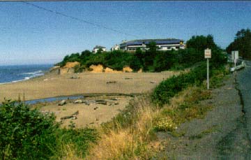
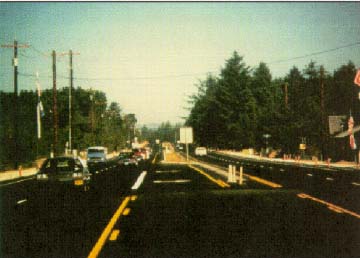
Reconstructed U.S. Route 101 shortly after project
completion. |
U.S. ROUTE 101 - LINCOLN BEACH PARKWAYLincoln County, OR |
 |
|
BACKGROUND/PURPOSE What has come to be called the "Lincoln Beach Parkway" is, in reality, a section of the Oregon Coast Highway (U.S. Route 101). Construction of the highway began in 1919 to ensure military preparedness. At that time, it was called the Theodore Roosevelt Coast Military Highway. The current name was adopted in 1931. Running adjacent to the Pacific Coast for nearly 565 km (50 miles), this route is one of the most scenic highways in the United States. Its elevation varies from near sea level to cliffs 305 m (1,000 ft) above the ocean. The road passes through a variety of urban, suburban, and rural landscapes. Major Traffic Growth Expected U.S. 101 serves local, regional, and tourist travel demands. Existing ADT volumes within the central coastal region through Lincoln County range from a low of approximately 5,000 vehicles per day at the southern county line to approximately 17,500 vehicles per day in the Lincoln City area. Year 2015 traffic projections forecast these volumes to increase to approximately 11,700 vehicles per day and 32,000 vehicles per day, respectively. Improved Access vs. Community Impacts A major conflict facing the entire Route 101 corridor is the need to provide better access to resortoriented communities to enhance economic development opportunities while balancing the impact of capacity improvements. This issue was particularly acute in Lincoln Beach, a city of 10,000, where new residential and resort developments, and access to them, contributed to increased congestion levels and a high accident rate. Initial Options
In 1992, jurisdictions along the highway approved the concept of a Pacific Coast Scenic Parkway to "increase the aesthetic experience, assist in access control, and develop community identity." These parkways were to deviate from typical ODOT design concepts by providing a raised center median and limited median breaks, while keeping direct access along both sides of the road. Land Use Control: A Paramount Factor An important point raised by the Lincoln County Council was the relationship of the project's design features to the County's Master Plan, which was designed to control strip development. The Lincoln Beach area is a lightly developed 3.2km (2mile) section of homes and small businesses that is in the path of urban growth.
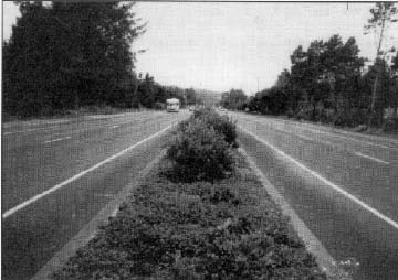
Parkway Concept Adopted Following the initial ODOT presentations of the parkway design concept, in 1988, the Lincoln County Commissioners sponsored a second public information meeting. The meeting was well attended by corridor residents and local business owners. As a result, the County Commissioners formally requested that the parkway design concept be implemented. Design was initiated shortly thereafter by ODOT staff, with final plans completed in May 1990. Construction began in August 1990. Construction was complete and the 3.2km (2mile) section was opened to traffic in July 1992. As finally constructed, the Lincoln Beach Parkway has a basic fourlane mediandivided cross section, with a curbandgutter closed drainage system and 1.2m (4ft) sidewalks along both sides. The cross section consists of two, 3.6m (12ft) travel lanes on either side of a typical 4.3m (14ft) raised, landscaped median. To accommodate bicyclists, the pavement on either side of the median was originally designed to include a 0.6m (2ft) left shoulder and a 1.8m to 2.4m (6ft to 8ft) right shoulder. However, the left shoulder is currently striped as 1.2 m (4 ft) wide and the right shoulder is typically 1.2 m to 1.8 m (4 ft to 6 ft) wide.
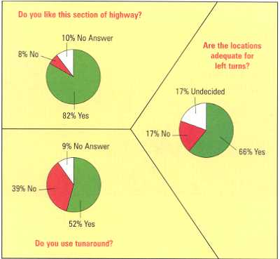
Favorable Public Reaction The reaction to the project by both local businesses and residents has been favorable, except for several of the business owners who complain about restricted access. Surveys of users of the facility conducted by Portland State University for ODOT should an 82 percent favorable rating by auto drivers and a 78 percent favorable rating by drivers of delivery and large trucks. Moreover, 77 percent of auto drivers and 79 percent of truck drivers expressed the view that the parkway is much safer than the previous twolane highway. Recent accident records verify this attitude survey. The records show that the accident rate along this section of parkway has been halved and is lower than on other threelane or fivelane sections of U.S. Route 101 that have similar traffic volumes and development density.
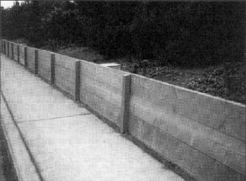
ENVIRONMENTAL AND DESIGN ISSUES AND CONSTRAINTS The Lincoln Beach Parkway design required resolution of the types of issues associated with the implementation of any highway improvement project in a developing suburban area. Residences and businesses with direct access from both directions along the old twolane highway now have access from only one side of a fourlane divided highway. At one point, a concrete soundwall was built to reduce the noise impact on residents of a trailer park, but the barrier also partially obscures the view of the entrance to a craft shop. ACTIONS TAKEN TO RESOLVE ISSUES Access Controls A complex issue addressed during design was the manner in which to ensure adequate access to adjacent properties. Where possible, median breaks were provided at existing public street intersections and these streets were repaved or reconstructed. In a few instances, closely spaced streets were consolidated into a single crossing point through the use of short sections of parallel connector street. The design of median breaks was tailored to allow for easy movement by oversize recreational vehicles and tour buses. Emergency Vehicle Access At street intersections where a median break could not be safely provided, special accesscrossing concrete payers were installed in the landscaped median to allow for fire and emergency vehicles to reach the areas. Raised pavement markers along the mountable median curb identify these locations. Special Turnaround Design In recognition of the large number of recreational vehicles and tour buses using the Route 101 corridor during the summer peak season, special turnarounds designed to accommodate fullsize buses were provided at the center and at both the northern and southern ends of this project. Postal Service Provisions An unanticipated benefit of the median construction resulted from the installation of mailboxes on both sides of the highway. Previously, all mailboxes were located on the northbound or east side of the twolane highway. Residents are now able to walk or bicycle to get their mail. Many residents believe this action, combined with sidewalks along both sides of the highway, has resulted in a more closely knit community than formerly existed. Community Enhancements The extensive use of native lowlevel plantings in the parkway median and along the perimeters of the roadway and sidewalks has led adjacent property owners to invest in site landscaping and related improvements. Landscaping also helps define the road edges in this area of frequent fog and 2.0 m (80 in) of annual rainfall.
Shoulder Width Exception The only formal design exception requested from FHWA by ODOT was a
reduction in the outside shoulder width from 3.0 m (10 ft) (the 1990
AASHTO Green Book minimum requirement for such rural arterial highways) to
2.4 m (8 ft). The 1994 edition of the Green Book now allows for use of
shoulders that are 2.4 m (8 ft) wide on such facilities. LESSONS LEARNED ODOT views the planning and design of the Lincoln Beach Parkway as a prototype for similar highway improvements that can be implemented along the U.S. Route 101 corridor. The early involvement of residents and businesses, in addition to local elected officials and traditional public agency representatives, is now viewed as standard departmental procedure to better involve all affected stakeholders. Documentation of the safety benefits associated with mediandivided arterial facilities, in contrast to the traditional ODOT threelane and fivelane urban crosssection design solutions, is an important result of this planning and design effort. The design treatments associated with the Lincoln Beach Parkway are viewed as a model for resolving future traffic management problems throughout Oregon, especially on U.S. 101. ODOT is now engaged in the second phase of the Coast Highway Corridor Master Plan development, which is concerned with the definition of more detailed access management plans and subarea planning and design studies, including the consideration of a number of throughtraffic bypasses around congested urban areas.
| |||||||||||||||||||||||||||||||||||||||
|
|
|