
High-Level Requirements for the US-75 Integrated Corridor in Dallas, Texas

April 30, 2008
Award# DTFH-61-06-H-00040
3. General System Description
Keeping in mind the vision of the ICM project, "Operate the US-75 Corridor in a true multimodal, integrated, efficient, and safe fashion where the focus is on the transportation customer", the management and operations of the corridor and the ICM will be a joint effort involving all the stakeholders. To effectively manage and operate the ICM concept, the US-75 Steering Committee recommended the creation of a central corridor decision-making body. This body – designated as the US 75 ICM Subcommittee – will consist of leadership level representatives from each of the stakeholders in the US-75 Corridor. Due to the number of agencies involved in ITS and traffic operations in the Dallas – Fort Worth Region, the subcommittee is envisioned to be a subcommittee of the Regional ITS Steering Committee. The membership will consist of members from each of the corridor agencies; however, membership will be on a rotational basis so that the size doesn't become too large.
The daily operation of the corridor will be coordinated through the existing arrangements and information will be exchanged through the center-to-center project, along with a Decision Support Subsystem which will distribute response plan requests and utilize the center-to-center interface to communicate to the various agency systems. The central point of coordination for the corridor will be the DalTrans facility, with TxDOT, Dallas County, and DART co-located at the facility.
All operations among corridor networks and agencies (e.g., activation of specific ICM strategies) will be coordinated via the Decision Support Subsystem. The US 75 ICM Subcommittee will investigate and prepare corridor response plans and rules-based response procedures for various scenarios that can be expected to occur within the US-75 Corridor. The chairman of the committee will be responsible, with the other agency/service operations officers, for configuring the subcommittee with respect to its functions and staffing for all hours of operations. Staff will be assigned by the corridor stakeholders to support daily operations, develop response plans, and analyze system deficiencies and needs, and general administration. Performance measurement and monitoring will be the responsibility of the US 75 ICM Subcommittee. The agency/service members, led by the chairman, will be accountable to the centralized decision-making body and make reports as the decision-making body designates.
Communications, systems, and system networks will be integrated to support the distributed corridor command center beyond DalTrans. Voice, data, video, information, and control will be provided to all agencies based on the adopted protocols and standards for the sharing of information and the distribution of responsibilities. The ICM will support the virtual nature of the corridor by connecting the member agency staff on a real-time basis via communications and other ITS technologies. While all the ICM operational strategies will be available for use, it is envisioned that only a subset of these strategies will be activated at any one time, depending on the operational conditions and events within the corridor.
The US 75 ICM Subcommittee, working with NCTCOG will conduct desktop scenario sessions to prepare, train and refine response plans for incidents, special events, weather, and evacuations. All the agency/service operations officers and staff will know their respective roles and responsibilities for any of the various situations the corridor may face and will be aided by the Decision Support Subsystem. Moreover, agency operations officers will be able and authorized to improvise as situations may dictate.
Traveler information via websites, DMS, and through the media and ISPs will be corridor-based, providing information on corridor trip alternatives complete with current and predicted conditions. Travelers will access or be given real-time corridor information so they can plan or alter their trips in response to current or predicted corridor conditions. Each traveler will be able to make route and modal shifts between networks easily due to integrated and real-time corridor information, integrated fare/parking payment system, and coordinated operations between networks. Using one network or another will be dependent on the preferences of the traveler, and not the nuances of each network. Travelers will be able to educate themselves about the corridor so they can identify their optimal travel alternatives and obtain the necessary tools to facilitate their use of corridor alternatives when conditions warrant.
The US-75 Corridor will be an integrated transportation system – managed and operated collectively – to maximize its efficiency to corridor travelers. All corridor assets will be attuned to obtain the goals and objectives of the corridor, as well as the goals of each individual traveler as their preferences prescribe. The corridor users will recognize the US-75 Corridor as a multimodal, integrated, efficient, and safe transportation system that provides them with multiple viable alternatives that they can select based on their specific travel circumstances and needs.
The operations and coordination of the corridor will utilize a Decision Support Subsystem as part of the daily operation of the corridor, and will be coordinated through the existing arrangements between the agencies with information exchanged through the center-to-center project. The center-to-center interface is an ITS standards based system utilizing the TMDD and MS/ETMC. The Decision Support Subsystem will distribute response plan requests and utilize the center-to-center interface to communicate to the various agency systems.
Figure 3-1 is a high-level framework on how the system will interface to the various agencies. The system would utilize existing Center-to-Center standards based communication infrastructure. It would also be able to have direct connections to agencies not on the Center-to-Center network. The existing systems of each member agency would share ITS data with the corridor, and the Decision Support Subsystem would recommend responses to all affected agencies.
The Decision Support Subsystem would be initially populated by response plans developed by the US-75 ICM Subcommittee utilizing the models developed for the corridor analysis and strategy selection. The decision support subsystem would evaluate conditions against the response plans, and recommend new response plans as network conditions and responses are evaluated.
The US-75 ICM Subcommittee will meet on a regular basis to do post-incident analysis and review any modification to response plans to improve the efficiency of the corridor. The Decision Support hardware and software will be hosted and maintained at the DalTrans facility.
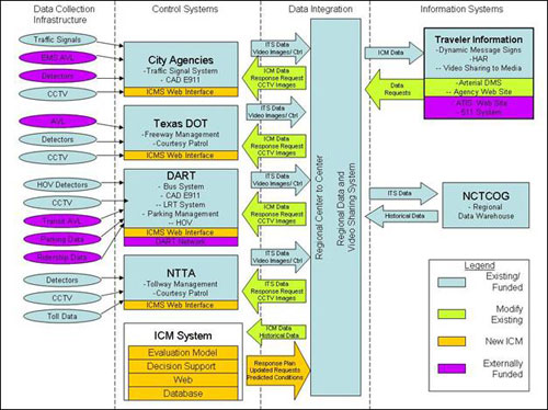
Figure 3-1 High-Level Integrated Corridor Management System Concept
The Decision Support Subsystem (DSS) will send response plan requests via the center-to-center interface to communicate to the various agency systems. The regional center-to-center interface is an ITS standards based interface, utilizing the Traffic Management Data Dictionary (TMDD) and the Message Sets for External TMC to TMC Communication (MS/ETMC). For instance, if TxDOT has an incident on the US-75 freeway, when the operator at the Daltrans facility inputs data in their ATMS incident management subsystem, the information from this subsystem would send basic information on the incident (such as location, number of lanes, severity) to the DSS via the regional Center-to-Center communication system. The DSS would then query its database based on this criteria, and select pre-approved response plans. The DSS would send the response plan recommendations to all affected agencies, and a notification to the regional ATIS. The agencies in the corridor would accept or modify the recommended response, based on current conditions within their network. As the conditions of the incident change, and the ATMS system is updated, the DSS would also be notified and send out updated responses, if needed. In addition, the DSS will send out updated responses based on other criteria. For instance, if an incident was occurring during the peak hours, and extended beyond. One potential response during the peak could be to increase the number of Light Rail Vehicles (LRV) in operation. If a certain time of day was reached before any updates were provided, the DSS may send DART an update that notifies them that additional LRT are not required.
3.1. System Performance Measures
Taking into account the vision, goals, and current conditions within the Corridor, the US-75 Steering Committee discussed "success" targets for several of the performance measures, their main concern was if the target was realistic, could be measured, and if enough data would be available. These "Performance Measures Success Thresholds," listed in Table 3.1-1, provide an indication that the corridor goals have been achieved. The listed performance levels/thresholds are long-term targets that reflect the future vision of how the corridor will operate. Upon deployment of the ICM, any movement toward the thresholds will indicate that ICM is having the desired effect. As data is collected in the next phase, and models developed the targets will be validated and goals adjusted to ensure realistic and achievable targets are used.
| Performance Measure | Performance Measure Success Threshold |
|---|---|
| Travel Time Index | Reduce Index by 2% per year |
| Travel Time | Light Rail - reduce travel time by 20% in downtown corridor Bus - reduce travel time by 20% in downtown corridor |
| Corridor Throughput | Increase overall throughput - increase person/trips per hour by 2% Increase throughput during incident - increase person/trips per hour by 2% |
| Clearance time for an Incident (based on Jurisdiction and Corridor) | Emergency Responder Training - 75% of agencies trained on Incident Management response. |
| Response time | Response to Incidents - target is consistent response between jurisdictions (within 5 minutes) |
| Revenue/ Cash machine Tickets for Transit | Increase in Ticket purchases during major incidents/ events - 10% |
| Parking Lot Volume at Transit locations | Parking Lot Capacity - 90% utilization |
| Ridership per vehicle (Transit) | Increase of ridership - 2% (year to year increase) |
| Queue wait time at intersections | Percentage of time stopped at intersections - reduce by 10% during peak period |
| Provide ATIS information to public on incident | Information to Regional ATIS - 10 minutes |
| Public Perception | Public Perception - Awareness of ICM and perceived benefits (survey based) |
| ICM Response Plan deployment | ICM Response Plan activated - 95% of plans were deployed correctly |
The performance measures and targets discussed above focus on assessing the overall effectiveness of the ICM and corridor operations for purposes of needs identification and improvement selections. Such parameters, however, are not conducive to day-to-day assessments of alternatives by travelers and are not sensitive to quickly changing conditions within the corridor.
Data collection for the performance measures (i.e., overall assessment) and operations measures will be identical, using the information collected by each of the individual network systems. However, their respective processing may be different. As mentioned previously, one of the focuses of the corridor is to utilize mesoscopic models to evaluate the strategies and assist with prioritization both as part of the Decision Support subsystem and the Evaluation Model subsystem.
3.2. System Context
Simply put, the Integrated Corridor Management concept seems to be a strong fitting solution for the Dallas US-75 Corridor. The needs and goals and related transportation operations within the Corridor, will only be met through a coordinated operation of the individual transportation networks.
The US-75 Corridor consists of multiple independent networks:
- Freeway
- Managed High-Occupancy Vehicle Lanes
- Tollway
- Arterials
- Bus
- Light Rail
Each of these corridor networks are experiencing congestion to some extent during peak hours. "Integrated Corridor Management" focuses on the operational, institutional, and technical coordination of multiple transportation networks and cross-network connections comprising a corridor. Moreover, ICM can encompass several activities which address the problems and needs identified in the previous section (e.g., integrated policy among stakeholders, communications among network operators and stakeholders, improving the efficiency of cross-network junctions and interfaces, real-time traffic and transit monitoring, real-time information distribution, congestion management, incident management, public awareness programs, and transportation pricing and payment).
The US-75 Steering Committee has identified multiple areas and strategies that would assist in operating the corridor in a more efficient and safe manner which in turn would have a positive impact to the overall economy of the region. The first major area deals with information sharing both with the public and among agencies. Currently the region has an ITS Standards based Center-to-Center program with a couple of the agencies integrated. This sharing of information could be used for better informing the public of the operations of the corridor and the availability and impact of different modes. The corridor could provide comparative travel time across modes, so that travelers can make informed decisions about trips they are about to make, this would include the ability to collect and distribute arterial travel time data via various media including through 3rd party ISPs, websites, and subscription services for phones and PDAs.
One of the areas multiple agencies identified that is needed is pre-planned response plans and a decision support tool to assist with the on-going operations of the corridor. This decision support tool would be integrated with the various agencies, and provide multi-agency responses to scenarios.
One of the deficiencies that needs to be addressed – and a specific attribute of the Regional ITS Architecture – involves the exchange and sharing of real-time data. With real-time data and video among the networks, each network could monitor the conditions of adjacent networks to anticipate when travelers may shift to their network and take appropriate actions. Moreover, real-time condition information would provide the foundation for corridor-wide traveler information. The corridor has solutions for both of these deficiencies – the current center-to-center project is used by some of the agencies within the corridor, but further expansion to all of the corridor agencies is needed. A Regional Data and Video Communication System is currently being designed that would serve as the central distribution point for sharing video among corridor agencies. Currently several cities, DART, and TxDOT share some of their video images.
Another element of ICM that is needed is outreach and marketing to the public and major employers within the corridor. Currently, many travelers utilize the regional website and 3rd Party ISPs (including Media) to find out about current conditions. One of the strategies identified by the stakeholders is outreach to major employers to provide customized traveler information to them; this could then be used as a potential way to allow diversion of travelers to use their overflow parking.
Another potential element of ICM involves enhanced mobility opportunities, including shifts to alternate routes and modes. Currently, any shifts that do occur are based on traveler knowledge and past experience. Using integrated real-time information, the various networks working as a corridor could influence traveler network shifts; especially promoting, when appropriate, shifts to the light rail network with its unused capacity. The one problem with influencing a shift to rail is the parking shortage. Parking notification could be used to direct travelers to available parking; or in some situations temporary parking may be instituted to handle the new demand.
Current and new DMS deployed among the networks could be operationally integrated and messages could be used to provide travelers condition information on all corridor networks so that each traveler can take appropriate action if one or more of the corridor's network's performance is compromised. More can be done with corridor trip travel times to influence traveler shifts, or staggering of the start of travel. For special events, the DMS could be used to direct event attendees to specific event corridor transportation services.
Clearly, there is great potential to enhance current and near-term operations by implementing selected ICM and cross-network strategies. All of these enhancements would not be possible from an independent network operational perspective. The potential strategies identified above indicate that further investigation and design concerning integrated corridor management is warranted.
3.3. System Modes and States
In order to get a better understanding of the overall ICM System, each of the agencies was analyzed to determine a before and after of its systems, interfaces, and data requirements for the ICMS.
3.3.1. City of Dallas
Dallas is the largest city in the urban area with a population of 1,210,390 – making it the 9th largest city in the United States, 3rd largest in Texas, covering 384 square miles. The City of Dallas municipal agency employs over 12,000 workers, with over 5,400 dedicated to public safety (police and fire). The Dallas Independent School District is comprised of 180 public elementary and middle schools and 37 public high schools. In addition, the metro area has 17 two-year and technical/trade colleges, 4 public four-year colleges and universities, and 17 private colleges and universities. Dallas is one of the top convention cities in the country, with 3,700,000 conference attendees per year. The City of Dallas also has two airports.
The City operates and maintains 1,300 traffic signals (most of which are in coordinated arterial signal systems); and 37 arterial Dynamic Message Signs (DMS), and 35 roadside cameras. There are 62 miles of bike & jogging trails and 500 miles of street bicycle routes. The Dallas Police Department provides incident management on all facilities within the City of Dallas except the HOV lanes and tollways.
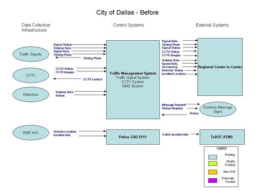
Figure 3.3-1 City of Dallas Systems - Before
As part of the ICM Deployment, several new linkages will be required. These include integration with the Decision Support Subsystem, and providing additional data to the corridor partners. The other main focus of the City of Dallas is to increase its data collection and dissemination capabilities in order to improve the corridor's operation.
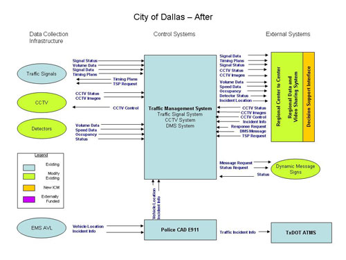
Figure 3.3-2 City of Dallas Systems - After
Additions to Systems and Infrastructure
In order to fill the infrastructure needs of the City and to have a completed data collection network, and traveler information system; additional detectors, DMS, and CCTV were identified as the largest need for the City. These will allow the ICMS to better monitor and predict traffic related issues within the corridor.
The following locations for additional CCTV were identified:
- Coit & Frankford
- Coit & IH 635
- US 75 & Forest
- US 75 & Royal
- US 75 & Walnut Hill
- US 75 & Park
- US 75 & Southwestern
- US 75 & Lovers
- US 75 & Mockingbird
- US 75 & Knox/Henderson
- US 75 & Blackburn/Haskell
- Peak & Ross
- Greenville & Mockingbird
- Greenville & Lovers
- Greenville & Park
- Greenville & Walnut Hill
- Greenville & Royal
- Greenville & IH 635
- Greenville & Restland
- Floyd & Restland
- Hillcrest & Arapaho
- Hillcrest & Beltline
- Hillcrest & Spring Valley
- Hillcrest & Alpha
- Hillcrest & IH 635
- Hillcrest & Forest
- Hillcrest & Loop 12 (Northwest Hwy.)
- Preston & Spring Valley
- Preston & Alpha
- Preston & IH 635
- Preston & Loop 12 (Northwest Hwy.)
- DNT & Royal
- DNT & Loop 12 (Northwest Hwy.)
- DNT & Lovers
- DNT & Mockingbird
- DNT & Wycliff
- Skillman & Mockingbird
- Skillman & Walnut Hill
- Skillman & IH 635
- Abrams & Forest
- Abrams & IH 635
- Forest & IH 635
- Forest & Audelia
- Abrams & Royal
- Abrams & Loop 12 (Northwest Hwy.)
- Shadybrook & Loop 12 (Northwest Hwy.)
- Boedeker & Loop 12 (Northwest Hwy.)
- DNT & Loop 12 (Northwest Hwy.)
The following locations for additional DMS were identified:
- SB Hillcrest approaching Arapaho
- SB Hillcrest approaching IH 635
The following locations for additional Detectors were identified:
- Speed/count detectors in 7 locations on Greenville Avenue, between the major east/west streets that have US-75 access: Mockingbird, Lovers, Caruth Haven, Park, Walnut Hill, Royal, Forest, IH 635;
- Speed/count detectors in 2 locations on Coit Rd., south of IH 635, north of IH 635.
3.3.2. City of Richardson
Richardson has a population of 97,800. The Richardson Police Department provides incident management on all facilities within its city limits except the tollways. The city operates a remote-access automated traffic signal system with over 120 intersections under control, and a count station network of 105 locations.
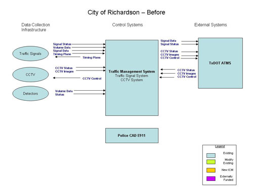
Figure 3.3-3 City of Richardson - Before
As part of the ICM Deployment, several new linkages will be required. These include integration with the Decision Support Subsystem, and providing additional data to the corridor partners. It is assumed that the linkages to the Regional Center to Center, and Data and Video Sharing System will be completed separate from the ICM projects. The other main focus of the City of Richardson is to increase its data collection and dissemination capabilities in order to improve the corridor's operation. The City does need additional DMS in strategic corridor locations, and detection capabilities to monitor the conditions of the arterial network.
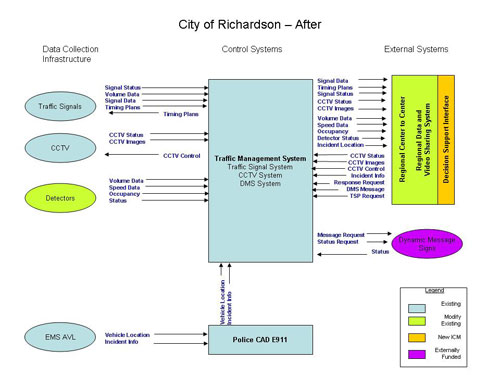
Figure 3.3-4 City of Richardson - After
Additions to Systems and Infrastructure
In order to fill the infrastructure needs of the City and to have a completed data collection network, and traveler information system; additional detectors, and DMS were identified as the largest need for the City. These will allow the ICMS to better monitor and predict traffic related issues within the corridor.
The following locations for DMS were identified:
- westbound on Centennial at Whitehall
- westbound on Belt Line at St. Johns
- westbound on Belt Line at Dorothy
- westbound on Arapaho at Bowser
- westbound Campbell at Glenville
The following arterials were identified for arterial detection:
- Coit Road
- Plano Rd
- Spring Valley/Centennial
- Belt Line
3.3.3. City of Plano
As described in the Concept of Operations, Plano is the second largest city in the urban area with a population of 249,000. The Plano Police Department provides incident management on all facilities within its city limits except the tollways. The city operates a remote-access automated traffic signal system with over 196 intersections under control.
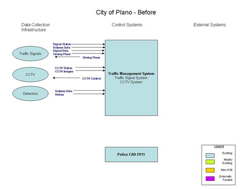
Figure 3.3-5 City of Plano - Before
As part of the ICM Deployment, several new linkages will be required. These include integration with the Decision Support Subsystem, and providing additional data to the corridor partners. It is assumed that the linkages to the Regional Center to Center, and Data and Video Sharing System will be completed. The other main focus of the City of Plano is to increase its data collection and dissemination capabilities in order to improve the corridor's operation. The City does need additional detection capabilities to monitor the conditions of the arterial network.
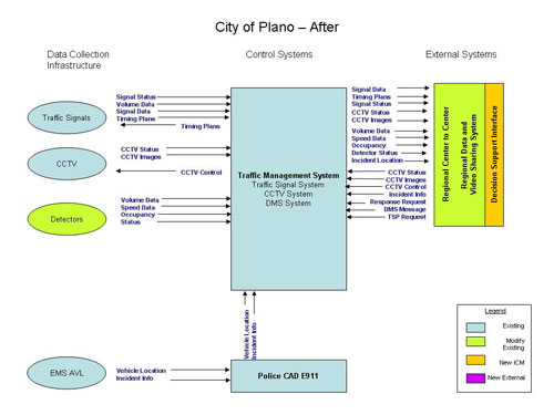
Figure 3.3-6 City of Plano - After
Additions to Systems and Infrastructure
In order to fill the infrastructure needs of the City and to have a completed data collection network, and traveler information system; additional detectors were identified as the largest need for the City. These will allow the ICMS to better monitor and predict traffic related issues within the corridor.
The following arterials were identified for arterial detection:
- Jupiter Road-From PGBT to Spring Creek Parkway
- Avenue K from south of Plano Parkway to Legacy Drive
- Alma Drive-From south of Plano Parkway to Legacy Drive
3.3.4. Town of Highland Park
As described in the Concept of Operations, the Town of Highland Park has a population of 8,800 with 13 isolated traffic signals. Although freeway or tollway facilities do not pass through the town, both types of facilities abut the town limits.
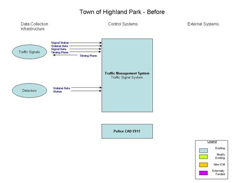
Figure 3.3-7 Town of Highland Park - Before
Since the Town of Highland Park has a small number of devices and routes within the corridor, a minimal deployment of the integrated system will be needed. As part of the ICM Deployment, several new linkages will be required. These include integration with the Decision Support Subsystem, and providing additional data to the corridor partners. It is assumed that the linkages to the Regional Center to Center, and Data and Video Sharing System will be completed. The other main focus of the Town of Highland is to increase its data collection and dissemination capabilities in order to improve the corridor's operation. The City does need additional detection capabilities to monitor the conditions of the arterial network. The main Arterial within the Town which is used by travelers is Mockingbird.
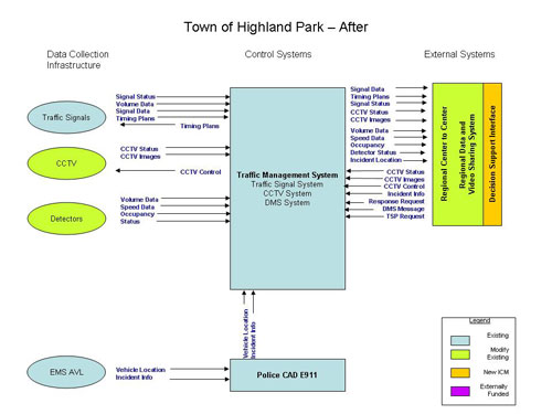
Figure 3.3-8 Town of Highland Park - After
Additions to Systems and Infrastructure
In order to fill the infrastructure needs of the City and to have a completed data collection network, and traveler information system; arterial detection within the city is needed on the major arterial in the city, along with some CCTV along the corridor.
The following arterials was identified for arterial detection and CCTV locations:
- Mockingbird
3.3.5. City of University Park
As described in the Concept of Operations, the City of University Park has a population of 23,300 with 33 traffic signals under coordination by three field masters. US-75 runs on the east side of University Park with a majority of the city to the west and a few city blocks to the east. The Dallas North Tollway runs along the western edge of the city.
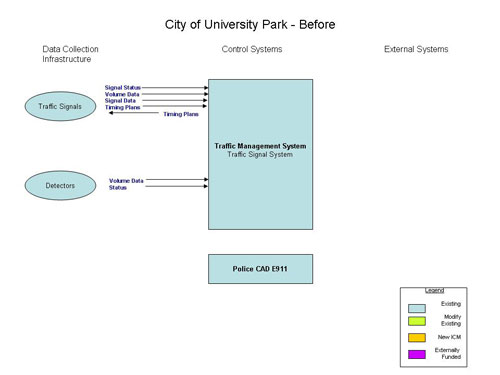
Figure 3.3-9 City of University Park - Before
Since the City of University Park also has a small number of devices and routes within the corridor, a minimal deployment of the integrated system will be needed. As part of the ICM Deployment, several new linkages will be required. These include integration with the Decision Support Subsystem, and providing additional data to the corridor partners. It is assumed that the linkages to the Regional Center to Center, and Data and Video Sharing System will be completed. The other main focus of the City of University Park is to increase its data collection and dissemination capabilities in order to improve the corridor's operation. The City does need additional detection capabilities to monitor the conditions of the arterial network.
Additions to Systems and Infrastructure
In order to fill the infrastructure needs of the City and to have a completed data collection network, and traveler information system; arterial detection within the city is needed on the major arterial in the city, along with some CCTV along the corridor.
The following arterials was identified for arterial detection and CCTV locations:
- Lovers Lane
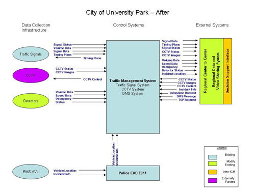
Figure 3.3-10 City of University Park - After
3.3.6. Texas Department of Transportation
As described in the Concept of Operations, the Dallas District of the Texas Department of Transportation (TxDOT) is responsible for the Design, Construction, Maintenance, and Operations of the US and State Highway System in seven counties in north Texas: Dallas, Denton Collin, Rockwall, Kaufman, Ellis and Navarro.
The US-75 Corridor from downtown Dallas passes through two counties (Dallas and Collin Counties) and four TxDOT Area Offices (of which three are located in Dallas County). Those offices being the Central Dallas Area Office, the Northwest Dallas Area Office, the Northeast/Rockwall Area Office, and the Collin County Area Office. These four offices have 318 employees. There are approximately 272 lane-miles of access-managed freeways in the US-75 ICM Corridor. TxDOT monitors most freeways within the Corridor via CCTV, private ISP providers, field units (enforcement and courtesy patrols), and other available sources along all but 14 highway miles in the Corridor.
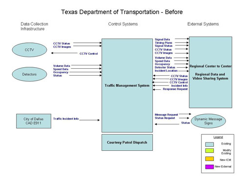
Figure 3.3-11 Texas Department of Transportation - Before
Since much of the TxDOT system is in place, there are only a few new items that are needed for the data requirements of the ICM, and the data distribution needs of the public. These include integration with the Decision Support Subsystem, and providing additional data to the corridor partners. TxDOT does need to deploy ramp meters, but this is not a priority. Two new DMS signs have been identified to fill-in the data distribution of the network, and additional detectors in areas that are currently not covered.
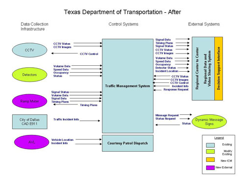
Figure 3.3-12 Texas Department of Transportation - After
Additions to Systems and Infrastructure
In order to fill the infrastructure needs of TxDOT and to have a completed data collection network, and traveler information system; additional detectors, ramp meters, and DMS were identified as the largest need for TxDOT. These will allow the ICMS to better monitor and predict traffic related issues within the corridor.
The additional infrastructure needs are:
- Completion of Ramp Meter sites, already in place along US-75
- Detectors will be need on US 75 particularly north of IH 635
- 2 additional DMS along the 28 mile corridor from downtown Dallas to SH 121
3.3.7. Dallas Area Rapid Transit
As described in the Concept of Operations, Dallas Area Rapid Transit (DART) – a regional transit agency authorized pursuant to Chapter 452 of the Texas Transportation Code – was created by voters and funded with a one-cent local sales tax in 1983. The service area consists of 13 member cities: Addison, Carrollton, Cockrell Hill, Dallas, Farmers Branch, Garland, Glenn Heights, Highland Park, Irving, Plano, Richardson, Rowlett and University Park. DART is governed by a 15-member board appointed by member-city councils based on population. Eight members are appointed by the City of Dallas and seven are appointed by the remaining cities. Board members serve two-year terms with no limits. Board officers are elected from the board membership and serve one-year terms.
Dallas Area Rapid Transit (DART) provides bus and light rail transit service throughout the Corridor. Currently, DART serves Dallas and 12 surrounding cities with approximately 130 bus routes, 45 miles of light rail transit (DART Rail), 31 freeway miles of high occupancy vehicle (HOV) lanes, and paratransit service for the mobility impaired. DART and the Fort Worth Transportation Authority ("the T") jointly operate 35 miles of commuter rail transit (the Trinity Railway Express or TRE), linking downtown Dallas and Fort Worth with stops in the mid-cities and DFW International Airport. Through 2014, the DART Rail System is slated to more than double in size to 93 miles. Extensions now in development include the 17.5-mile Northwest Corridor serving downtown Dallas, American Airlines Center, the Dallas Medical/Market Center, Love Field Airport, and the cities of Farmers Branch and Carrollton.
The 45-mile DART Rail System provides fast, convenient service to work, shopping and entertainment destinations in Dallas, Plano and Richardson. Free parking is available at most rail stations, and all are served by bus routes timed to make transfers easy. Popular shopping, dining, and entertainment destinations near DART Rail stations within the US-75 Corridor include NorthPark Center and the Upper Greenville Avenue area (Park Lane Station), West Village (subterranean Cityplace Station), Mockingbird Station (Mockingbird Station), the Dallas Museum of Art (St. Paul Station), the historic West End District (West End Station), American Airlines Center (Victory Station), the Dallas Convention Center (Convention Center Station), the Renaissance Hotel and Eisemann Center for the Performing Arts (Galatyn Park Station in Richardson); Downtown Plano, the ArtCentre of Plano, and the Courtyard Theater (Downtown Plano Station).
DART operates all HOV facilities within the Dallas Region, including a Motorist Assistance Patrol on HOV facilities. Buses, motorcycles, vanpools and carpools with two or more occupants are eligible to use DART's 31-mile network off HOV lanes. DART operates HOV lanes on East R. L. Thornton Freeway (I-30) between Downtown Dallas and Jim Miller Road; Stemmons Freeway (I-35E) between LBJ Freeway (I-635) and Round Grove Road; LBJ Freeway between North Central Expressway and Stemmons Freeway; and I-35E/US 67 south of Downtown Dallas. Dynamic Message Signs, lane control signals, changeable message signs, and cameras associated with the HOV lane facilities are operated from the ITS Satellite Control Center at a DART/TxDOT facility. DART's Transit System Plan calls for 116 miles of managed HOV lanes. HOV lanes are jointly planned and designed by DART and the Texas Department of Transportation. DART is responsible for facility management, operation, and enforcement.
3.3.7.1. DART Network
One of the systems beginning to be developed and deployed for DART is the DART Network. The DART Network will integrate the systems within DART into a single data exchange and repository system allowing for the integration of the DART systems and provide a single interface for the Regional Center to Center network.
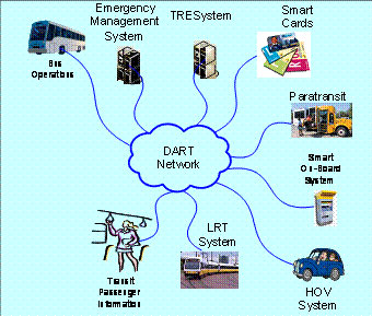
Figure 3.3-13 DART Network (Source: DART)
3.3.7.2. DART Police
The DART Police have the responsibility of providing enforcement and public safety for all of DART services, to include the HOV, Bus, and Light Rail Transit systems. DART Police utilize a Computer Aided Dispatch (CAD) to collect information and dispatch officers in response to incidents.
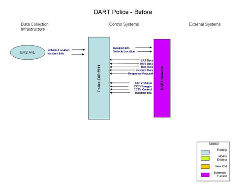
Figure 3.3-14 DART Police - Before
Since the DART police provide the enforcement and assist with incident management in the corridor, they have data on incidents, and locations. For all of the DART systems, the DART Network will be completed and connected to the Regional Center to Center for exchanging data, and for actively managing the corridor.
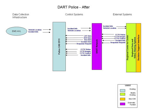
Figure 3.3-15 DART Police - After
3.3.7.3. DART Light Rail
The primary light-rail line within the US-75 Corridor is the Red Line which runs north-south. The portion of the Red Line within the Corridor Boundaries runs from the Downtown Dallas station (Convention Center Station) to the northern-most station (Parker Road Station) in the City of Plano. Between these two endpoints, there are a total of 17 rail stations.
In addition, the Blue Line runs in the US-75 Corridor Influence Area from Downtown Dallas to the Mockingbird Lane Station (approximately three miles). From the Mockingbird Lane Station, the Blue Line runs into the City of Garland. The Blue Line is the eastern-most boundary of the larger Corridor Influence Area and could serve as an alternate rail route into downtown if there were problems with the Red Line.
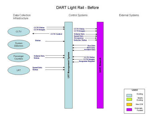
Figure 3.3-16 DART Light Rail - Before
As discussed in the Concept of Operations, the LRT will serve as a major part of the modal shift within the corridor. This includes additional parking, parking management, and providing more real-time information on capacity and volumes of the LRT system. For all of the DART systems, the DART Network will be completed and connected to the Regional Center to Center for exchanging data, and for actively managing the corridor.
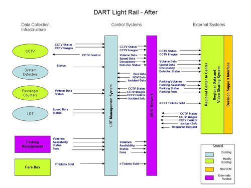
Figure 3.3-17 DART Light Rail - After
3.3.7.4. DART HOV
The US-75 HOV Lane opened for operation in December 2007, the HOV lane is a single concurrent flow lane in each direction separated from the general purpose traffic by a painted buffer area with pylons to provide physical separation. The HOV lane is 15 miles in length (these are new miles being added to the existing 31-mile system) and extends from the northern end of the Corridor (Exchange Parkway and US-75) to the I-635 interchange.
There are three access points in each direction to the HOV lane within the Corridor. The northern end has a slip ramp from the inside lanes of the freeway. Near the I-635 interchange there are "wishbone" type ramps for traffic to enter and exit the facility.

Figure 3.3-18 DART HOV - Before
The DART HOV Operations are co-located at DalTrans with the TxDOT operations. Much of the information provided by the HOV systems is needed for the operations of the corridor. For all of the DART systems, the DART Network will be completed and connected to the Regional Center to Center for exchanging data, and for actively managing the corridor.
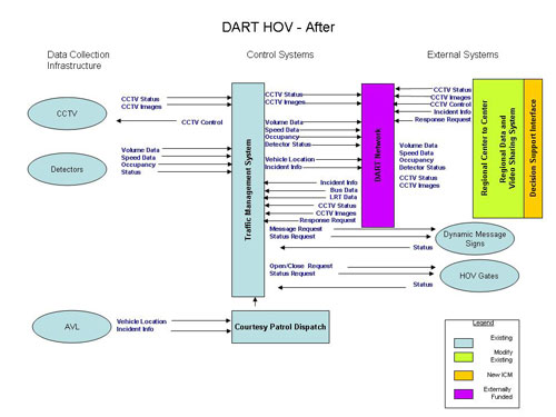
Figure 3.3-19 DART HOV - After
3.3.7.5. DART Bus
The bus transit Network within the US-75 Corridor Boundary consists of various types of services. There is local bus service serving specific areas characterized by frequent stops. In addition, express routes and cross-town routes that serve longer distance trips. Express routes have less frequent stops and generally run on the primary arterials within the Corridor.
There is also a light-rail station feeder bus service. These bus lines transport passengers traveling between light-rail stations. In total, there are 30 express routes and an additional 12 special routes in the US-75 Corridor.
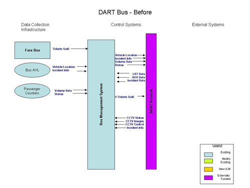
Figure 3.3-20 DART Bus - Before
As discussed in the Concept of Operations, the Bus system will also serve as a major part of the modal shift within the corridor. For all of the DART systems, the DART Network will be completed and connected to the Regional Center to Center for exchanging data, and for actively managing the corridor.
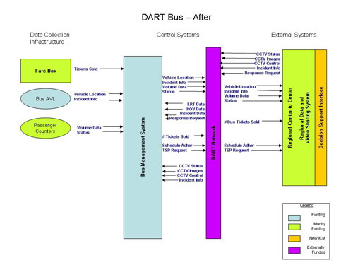
Figure 3.3-21 DART Bus - After
Additions to Systems and Infrastructure
Since a major goal of the ICM is for Modal Shift, DART plays an important role in this effort. In order to improve the data collection of the system, and to provide for the corridor, several new systems and improvements to the infrastructure were identified. These will allow the ICMS to better monitor and predict traffic related issues within the corridor.
New Systems and Infrastructure Identified include:
- Transit Signal Priority
- Passenger Counter System on all Buses
- Passenger Counter System on all Light Rail Transit
- 2 Additional Light Rail Vehicles (LRV)
- Parking Management System
- Fare Box Counters – real-time
- Additional CCTV at Rail Stations, and Parking Lots
3.3.8. North Texas Tollway Authority
The NTTA operates both the President George Bush Turnpike (PGBT) and the Dallas North Tollway (DNT). The PGBT is an east-west toll road that intersects the Corridor in the northern section. The PGBT provides access to several of the north-south arterials to the west as well as the DNT. The DNT is the other major north-south controlled access facility. The north-south arterials and the DNT have the ability to serve as alternate routes to destinations in the US-75 Corridor.
The DNT has three mainline plazas with both high-speed electronic toll collection-only (ETC) lanes, and toll booth lanes that accept either electronic or cash payment. There are also ten ramp access locations that accept both electronic and cash payment.
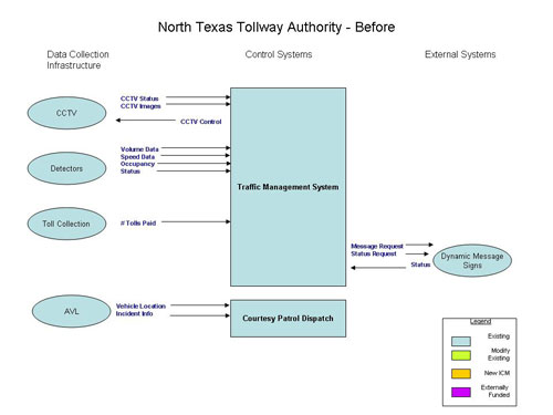
Figure 3.3-22 North Texas Tollway Authority Systems - Before
Additions to Systems and Infrastructure
NTTA has the majority of its infrastructure in place, or planned and funded. For the ICMS, the biggest need is the data sharing and integration with the other agencies within the corridor. It is assumed that NTTA will be connected to the Regional Center to Center and the Regional Data and Video Sharing Systems.
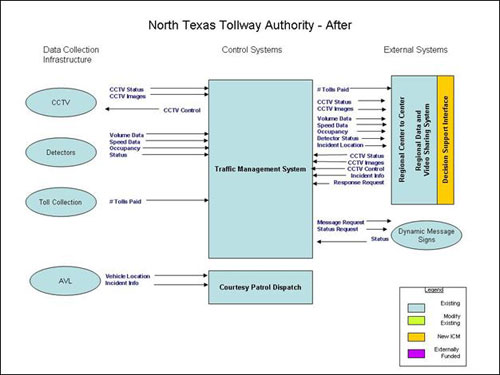
Figure 3.3-23 North Texas Tollway Authority Systems - After
3.3.9. Decision Support Subsystem
As described in the Concept of Operations, the operations and coordination of the corridor will utilize a Decision Support Subsystem as part of the daily operation of the corridor, and will be coordinated through the existing arrangements between the agencies with information exchanged through the center-to-center project. The Decision Support Subsystem will distribute response plan requests and utilize the center-to-center interface to communicate to the various agency systems, as shown below in Figure 3.3-24.
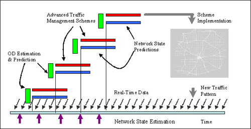
Figure 3.3-24 Decision Support Subsystem Framework
Figure 3.3-25 and 3.3-26, below, show the data flows into and out of the Decision Support Subsystem to create a real-time system which will provide response plan requests, monitor current network conditions, and provide some prediction on future conditions. These capabilities will allow the corridor agencies to be pro-active in responding to current and potential network conditions.
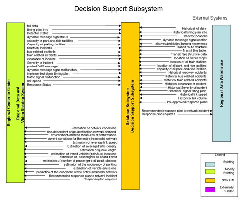
Figure 3.3-25 Decision Support Subsystem
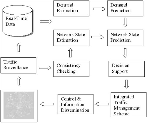
Figure 3.3-26 Decision Support Subsystem Data Flow
A basic functional requirement of real-time traffic management system is to be able to predict the traffic congestion pattern and to develop a real-time integrated management scheme to alleviate this congestion. State prediction of urban traffic networks is a complex process. It requires estimating the current state of the network, predicting the future travel demand over the prediction horizon, and projecting the temporal-spatial traffic evolution as the outcome of demand interaction with the supplied roadway capacities and the adopted control strategies.
Estimating the current state of the network is a data driven operation. A real-time data stream that describes the current state of the different network elements is obtained through a distributed surveillance system. In case of partial network coverage, a supporting network state estimation module is used to provide an estimate of the missing data elements. Predicting the future travel demand over the prediction horizon combines historical origin-destination trip tables and the observed real-time data to estimate the current time-dependent trip tables, and to use this estimation as a basis to predict the future travel demand pattern.
Projecting traffic evolution and associated congestion pattern starts by acquiring a snapshot describing the current state of the entire network and the future origin-destination travel pattern over the prediction horizon. The network state prediction module predicts travelers' mode-route choice decisions as function of the evolving congestion pattern and the adopted control strategies. The anticipated operation performance of the different network elements is captured as the outcome of the travelers' collective decisions. Based on the predicted performance, an efficient traffic management scheme is developed. The scheme integrates several advanced traffic and transit management strategies including real-time adaptive signal control, travelers' information provision strategies, automated incident detection and emergency management systems, dynamic congestion pricing systems, transit vehicle location identification systems, transit and emergency vehicle preemption, real-time transit dispatching systems, etc. Figure 3.3-27, below, shows a sample of the system interface under development by SMU for the ICM project.
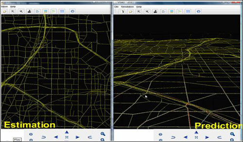
Figure 3.3-27 Decision Support Subsystem Interface (Source: Southern Methodist University)
3.3.10. System Modes
Since the decision support system will be used as an operational tool for the corridor two modes of the system are needed, a production and a test mode. The test mode would be used to verify the system works correctly without modifying or creating false data into the regional systems. The test mode would utilize a set of test data that could be used for verification and testing of the decision support system.
3.4. Major System Constraints
This section summarizes the problems, issues and needs of the individual Networks and the Corridor as a whole. Using the inventory information and other gathered data, coupled with stakeholder discussions, this section addresses operational, technical, and, institutional deficiencies and constraints, As such, it provides insight into the types of problems being faced in the US-75 Corridor.
Within the US-75 Corridor, the challenges in efficient movement of people and goods can be classified in terms of 1) agency coordination, 2) available capacity, and 3) proactive operational and control strategies.
3.4.1. Network Challenges
Agency Coordination: First, the Corridor encompasses multiple modes of transportation and a variety of facilities. It also encompasses multiple operating agencies with various responsibilities for providing transportation services. These operating agencies include five cities, two counties, a state department of transportation, a transit authority, a regional tolling authority, a metropolitan planning organization and a large number of local emergency service providers. While the various agencies generally operate in a cooperative manner, there are limited systems and tools for integrated coordinated operation.
One example where data is exchanged is between Texas Department of Transportation (TxDOT), the Dallas 911 system, and Metro Traffic (one of the local information service providers). The TxDOT Dallas District ITS central system receives traffic incidents from Dallas related to incidents, events, or other actions is accomplished via email or telephone. There is not, however, a Corridor-wide automated mechanism for improved sharing of data, control strategies, and response plans.
For example, a major incident may occur on a freeway and block travel lanes for an hour or more. Drivers may reroute based on information from Dynamic Message Signs (DMS) or from Information Service Providers (ISPs). There exists an opportunity for a modal shift to transit, a travel schedule shift, or a route shift if there is a mechanism in place for the affected agencies to act. Even with recurrent congestion, there exists an opportunity for modal, schedule, or route shifts with exchange of information among agencies along with communication to travelers. Such exchange of information and an action plan can better balance available capacity either in time or space. In either case - recurrent or non-recurrent congestion - agencies would be able to manage travel in a more coordinated manner with improved exchange of information and a coordinated action plan taking into account available capacity from all modes.
During 2005, the TxDOT freeway management system logged over 8,500 incidents on US-75 and over 5,000 incidents on I-635 within the Corridor boundaries. These incidents ranged in severity from debris in the roadway, to stalled vehicles, to major vehicle crashes with multiple lane closures.
Available Capacity: Second, the Corridor represents a highly-developed, urbanized area. As such, there is limited right-of-way remaining to expand the freeway and arterial streets. Therefore, the vehicle capacity is set, and the ability to handle future demand increases relies on moving more people on the given modes and effectively utilizing the existing capacity in real-time as both demand and capacity fluctuate.
Proactive Operational and Control Strategies: Third, maintaining mobility and safety in the Corridor will require proactive operational and control strategies implemented in an integrated manner among the agencies in the Corridor. Whether it is responding to the high travel demand each day or responding to special and planned events in the Corridor, there is a need to coordinate available capacity to match changes in demand. Furthermore, traveler information must be provided to inform users of travel alternatives to maximize their trips.
While the Corridor Stakeholders are in agreement that the principal mobility challenge in the Corridor is the daily traffic demand, there are a significant number of special events at venues in or near the Corridor that add additional challenges for mobility, safety, and wayfinding.
3.4.2. Network Needs
Many of the operational deficiencies within the US-75 Corridor were identified in the Concept of Operations, representing a major problem along most of the networks within the Corridor. Specific examples of additional needs relating to separate Network, as well as the Corridor as a whole are discussed below. These needs were established through a dedicated Corridor Stakeholder interviewing process, as well as by general input throughout the process of developing this Con Ops.
Arterial Network Needs
- Increased communications infrastructure between agency systems/centers, especially for video sharing
- Optimization / retiming of traffic signals – especially on established detour routes within Corridor
- Signal systems that better react to current travel conditions (rather than time-of-day) – i.e., deployment of traffic responsive signal systems along arterials throughout corridor.
- Collection and use of real-time traffic conditions along arterials – volume data is needed along with speed data
- Increase city traffic management office access to 911 / Emergency CAD data to better manage signal system based on incidents effecting traffic on arterials
- Improved incident management policies for incidents on arterials – different than freeways
Freeway Network Needs
- Increased freeway travel data to distribute accurate traveler information
- Increased mediums for distributing freeway traveler information, e.g., automated emailing of incidents based on personalized travel preferences
- Processing accurate freeway travel times
- Increased sharing of existing freeway travel speed data to other agency systems
- Relaying freeway travel times to travelers, specifically on DMS
- Making freeway travel times available to other agencies for operational use and distribution to travelers
- Steaming video to travelers
- Improve ability to delineate the events that will effect highway mobility from within integrated data from 911/Emergency CAD system
- Improve ability for appropriate TxDOT personnel to be alerted by 911/Emergency CAD events that effect transportation system
Transit Network Needs
- Signal priority capability for light rail transit
- Signal priority for bus transit vehicles (especially near transit centers)
- Increased coordination between DART and Cities for management and public information distribution relating to transit line closures
- Ability to accurately measure bus and rail ridership in real-time
- Need ability to alert (not just broadcast) customers about service disruptions, both pre-trip and en-route (probably via wireless medium, e.g., cell phones or PDAs)
- Need better parking management at park-n-ride facilities, e.g., traveler information about lots being full
- Need for automated payment collection at park-n-ride lots
- Increased information sharing within DART so that bus operators know about problems on rail, and vice-versa
Incident Management / Field Operation Needs
- Increased outreach/education for local police & fire in incident response procedures related to traffic management, i.e., keeping traffic moving where possible
- Increased coordination with incident responders to communicate operational decisions, including between TxDOT maintenance, local police, local fire, towing, and EMS personnel.
- Need for interoperable communication between incident responders of all agencies
Multi-Network Needs
- Getting freeway travel times and incidents to travelers along arterials prior to getting on freeway.
- Additional mediums for distributing travel conditions to travelers en-route, e.g., via cell-phones or PDAs.
- Ability to effectively communicate diversion routes to travelers who may be unaccustomed to alternate routes, e.g., use dynamic trailblazing signage.
- Proven systems for predicting operating conditions in order to make operational decisions.
- Ability to measure mode change when put into affect as traffic management tool
- Increased sharing of video
- Increased sharing of travel conditions along all networks, so that information about problems on one network can be relayed to travelers who seek to transfer from another network
- Access to real-time information about incidents, including what agencies and/or resources are at the incident scene
- Ability to effectively relay travel time and/or delay information for all modes to travelers en-route so that travel decisions can be made
- Need for real-time volume data on all modes, not just flow data
- Integration of existing bus location data (for flow information) to freeway systems
- Public outreach and education to traveling public who's unaccustomed to use of alternate modes of travel, e.g., education program to explain use of park-n-ride lots and transit fare payment options.
Institutional / Coordination Needs
- There is a need for formalized agreements to define data and video sharing protocol between partner agencies.
- There is a need for formalized standard operating procedures for multi-agency shared control of ITS devices through integrated systems
- There currently is no clearly defined and agreed-upon performance measures for determining the effectiveness of multi/cross-network operational management
- There needs to be increased coordination between agencies about what real-time data is being collected and how it can be made available
- Increased focus of Corridor Stakeholders for integration of existing system, rather than deployment of additional non-integrated systems
- Acquiring decision-maker/political support for ICM concepts, specifically the City Councils and RTC
3.5. Assumptions and Dependencies
Since the practice and concepts of ICM are relatively new, several system, technology, and institutional assumptions were made in the development of the requirements. These assumptions may prove false once more is known, and ICM deployment is completed. However, based on the information we currently have on ICM and the corridor, these are our best assumptions.
3.5.1. System Assumptions
- The Regional Center to Center will be sufficient for the data exchange needs of the ICM
- The Regional Center to Center will be fully deployed
- The Regional Data Warehouse will be fully deployed
- The TMDD and MS/ETMC standards deployed as part of the Regional Center to Center will be sufficient in most cases for the data needed for the ICM System
- Communication links between all US 75 stakeholders are completed
- Current deployed infrastructure and systems will be utilized
- This is a research project, so some of the technology and systems deployed may need to be altered once operations have begun
- Current and proposed infrastructure will be sufficient for the data requirements of the ICM, and the real-time Decision Support Subsystem
3.5.2. Technology Assumptions
- Utilize the existing Regional Center to Center system
- Utilize the Regional Video and Data Sharing System
- Existing systems will sufficient for the needs of the system
- DART Network will be deployed
- Regional Data and Video Sharing System will be deployed
- Regional Center to Center plug-in will be deployed for each partner
- Current agency specifications for equipment will be utilized
- Current agency user authorization and authentication practices will be used
- Current agency information technology standards (hardware/ software) will be used
- Decision Support Subsystem will include an API, and web interface for agency's to utilize
- A Regional 511 system will be deployed
- Arterial detection will use both Tolltag readers and point detectors along the recommended arterials
3.5.3. Institutional Assumptions
- An Operator at DalTrans will be the corridor coordinator
- Funding will be available for ICM
- Agencies within the corridor will be willing to optimize the entire corridor, even if it impacts their individual network
- Regional Transportation Council and NCTCOG are supportive of the ICM and will provide funding, when needed
3.6. Operational Scenarios
When deciding upon locations of events that drive operational scenarios for the US-75 ICM Con Ops, it was decided that varying locations would require varying response scenarios depending on both location and time-of-day. In order to capture the various ICM response strategies, the Corridor was divided into multiple sections and directions. Then based on time-of-day, the impact and necessary strategies could be determined. With the time available to the US-75 Steering Committee, a typical location and scenario was chosen for the majority of the scenarios.
The committee also tried to identify incidents that typically occur as frequently as possible, as well look at recurring areas of congestion for daily operations, and high frequency locations for incidents. The US-75 Steering Committee discussed how ICM in the future could be used to improve the efficiency and response of the coordinated response.
3.6.1. Daily Operations
Daily operation is defined as:
- Operations that are not related to a particular incident/event that causes response or management strategies to be carried out, however minor incidents are routine and a part of daily operations.
- Recurring congestion and peak ridership conditions
Operations are not related to a particular incident/event that causes response or management strategies to be carried out; however, minor incidents are routine and a part of daily operations.
- Recurring congestion and peak ridership conditions
Table 3.6-1 below, provides roles and responsibilities for Stakeholders who perform significant functions during Daily Operations within the US-75 ICM Corridor.
| Stakeholder | Roles and Responsibilities |
|---|---|
|
Texas DOT |
Coverage
Monitoring
Coordination
Information Distribution
Maintenance
|
|
City of Dallas |
Coverage
Monitoring
Coordination
Information Distribution
Maintenance
|
|
City of Richardson |
Coverage
Monitoring
Coordination
Information Distribution
Maintenance
|
|
City of Plano |
Coverage
Monitoring
Coordination
Information Distribution
Maintenance
|
|
DART |
Coverage All
Rail
HOV
Bus
Monitoring All
Bus
Rail
HOV
Coordination All
Bus
Rail
HOV
Information Distribution
Maintenance
|
|
North Texas Tollway Authority |
Coverage
Monitoring
Coordination
Information Distribution
Maintenance
|
|
Town of Highland Park |
Coverage
Monitoring
Coordination
Information Distribution
Maintenance
|
|
City of University Park |
Coverage
Monitoring
Coordination
Information Distribution
Maintenance
|
ICM Strategies that will be deployed during Daily Operations Conditions include:
- Automated information sharing
- Shared control of "passive" ITS devices
- Information clearinghouse
- A corridor-based traveler information database
- En-route traveler information devices used to describe current operational conditions on another network(s) within the corridor
- Transit signal priority
- Multi-modal electronic payment
- Transit hub connection protection
- Multi-agency/multi-network incident response teams and service patrols
- Accommodate cross-network shifts
The remaining scenarios were developed based on deviation from the baseline of "Daily Operations" – since many of the agencies deal with minor incidents as a routine, they decided that they are a part of daily operations.
3.6.2. Traveler Information
Since all scenarios have some component of traveler information, it was decided to include a discussion and description of the traveler information assets existing and needed for the US-75 ICM and for the region as a whole.
The traveler information capabilities for the US-75 ICM will involve multiple media, and varied capabilities. This includes existing systems for pre-trip planning, in-route traveler information, and general information regarding the transportation network. This element encompasses many different types of information that can be of use to the traveling public. Through the traveler information technologies that we propose to utilize and continue to deploy, information will be provided regarding incidents, congestion, travel times, road conditions, pricing, transit status and parking availability.
For example, when there are incidents, incident information will be provided to minimize adverse impacts and enable the public to make decisions on options for the use of work hubs or work from home alternatives. Transit information alternatives will be provided so that commuters can determine the status of the bus or light rail system and find out about the availability of parking in DART parking lots in the vicinity of LRT stations in order to avoid an incident or congestion.
The delivery methods to be employed in US-75 corridor will consist of:
- Dynamic message signs (DMS) placed at strategic locations
- Interactive traveler information websites that commuters can quickly check each morning or go to anytime for corridor information
- Traveler information service retailers who will take the data collected and provide value-based services for their customers
- A robust 511 phone system that will provide traffic conditions, road conditions, and transit information
- Media partnerships with television and radio formed to provide them with traveler information and camera feeds for rebroadcast
- A personalized traveler alert system that will enable travelers to create route specific alerts based on the parameters they enter
- This component will also feature an in-reach and outreach program to garner support from public and private sector partners
3.6.3. Incident Scenario
When discussing Incident scenarios, the US-75 Steering Committee discussed how multiple locations would require multiple response scenarios depending on location and time of day. Based on time of day and jurisdiction, the impact and necessary strategies would be determined.
Major Traffic Incident – Arterials:
Since there are multiple Cities within the corridor, each with different infrastructure and integration – a sample major incident was chosen at a particular intersection where vehicle accidents occur regularly, and have major impact on overall mobility within the Corridor. Each of the five city US-75 ICM Stakeholders, has a primary arterial street that is used during peak hours for public and transit vehicles. Since many of the arterials are collectors or parallel routes to the freeway, many have very high volumes during peak times.
Incident Description:
During the evening peak, an incident occurs at the intersection of Greenville Avenue and Spring Valley Road that closes the intersection for the evening rush. Since it is a parallel route which feeds US-75, it does have some preliminary impact to US-75, as well as overall mobility within the Corridor.
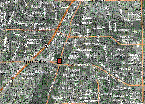
Figure 3.6-1 Incident Location at Intersection of Greenville Avenue and Spring Valley Road (Source: NCTCOG dfwmaps.com)
Assumptions:
- Major parallel route to the freeway, with impact to the corridor
- Multiple bus routes impacted
- Incident does not include any fatalities
Timeline:
| 4:00 p.m. | Incident Occurs, drivers immediately contact E911 to report the incident. Due to integration with the various E911 CAD systems, the corridor agencies are immediately notified of the potential incident (through ICM System alerting subsystems) and approximate location (through ICM System mapping). |
| 4:05 p.m. | City of Richardson police arrive on scene and begin initial determination of severity and approximate time for resolution. DART Bus Dispatch is automatically notified by the ICM system of the location, and drivers on affected bus routes are notified. |
| 4:20 p.m. | City of Richardson updates ICM System to indicate major incident with a closure of more than 1 hour. The corridor agencies are alerted through ICM alerting subsystem, and a previously approved response plan is recommended by the corridor Decision Support subsystem. Incident data is transferred to the DFW ATIS, resulting in information on the incident being sent to local media, and 3rd party ISPs, along with traveling public through various mediums. TxDOT, DART, and City of Richardson display preliminary information on DMS signs and HAR near the incident. DART displays intersection closure information on the vehicle and bus stop DMS along the affected routes. |
| 4:30 p.m. | City of Richardson implements timing plans for diversions around the intersection to parallel routes, and bus priority is implemented for pre-approved diversion routes for DART buses impacted by the intersection closure. |
| 5:00 p.m. | Initial clearance of the intersection, restoring traffic flow in all directions, City of Richardson updates ICM System. City of Richardson continues to monitor the traffic flow and change timing plans, if needed. DART and TxDOT remove DMS messages. DART is notified of opening, however, back-up still requires diversion |
| 5:20 p.m. | Normal operations, DART bus resumes routes through intersection. |
Changes to Baseline Strategies:
The approach the US-75 Steering Committee has taken is to use the Daily Operations as the baseline for the strategies associated with the ICM, and then discuss what changes and additions are needed for the specific scenario. In the following tables, the stakeholders have identified some of the additional roles and responsibilities, and data and infrastructure required to have a corridor based response. In addition, the following changes to strategies were identified:
- Information sharing and distribution
- Operational efficiency at network junctions
- A common incident reporting system and asset management (GIS) system
- Modify transit priority parameters to accommodate more timely bus service and light rail service
- Emergency response signal priority
- En-route traveler information devices used to describe current operational conditions on another network(s) within the corridor
| Stakeholder | Roles and Responsibilities |
|---|---|
| Texas DOT |
Monitoring
Coordination
Information Distribution
|
| City of Richardson |
Monitoring
Coordination
Information Distribution
|
| DART |
Monitoring
Coordination
Information Distribution
|
Major Traffic Incident – Freeway
When deciding upon locations for scenarios multiple locations would require multiple response scenarios depending on location and time of day. In order to capture the various response strategies for a major incident, the corridor was divided into multiple sections and directions. Then based on time of day, the impact and necessary strategies could be determined. With the time available to the US-75 Steering Committee, a typical location and scenario was chosen.
Trying to use a real-world incident, the committee discussed a recent incident on US-75 at the LBJ Freeway. During the early morning hours (approximately 4 a.m.), a northbound commercial vehicle incident closed multiple exit ramps to include the interchange to LBJ. The commercial vehicle lost its load, and required clean-up and hazmat response due to over 50 gallons of diesel being spilled. The City of Plano emergency response arrived first at scene and closed three exit ramps to include the one to LBJ Freeway, a little later the City of Richardson arrived and took over responsibility. The City of Richardson opened a couple of the exit ramps. The TxDOT courtesy patrol assisted with traffic control, and began clean-up of incident. The incident went through multiple phases: initial reaction, clean-up, modifying traffic control, and resumption of normal operations. The US-75 Steering Committee discussed how ICM in the future could be used to improve the efficiency and response of the coordinated response.
Incident Description:
A commercial vehicle jackknifed on southbound US-75 north of the LBJ Freeway interchange at 6 a.m., spilling its load of boxes onto the freeway and closing the freeway in the southbound direction. The jurisdiction of the incident is the City of Richardson.
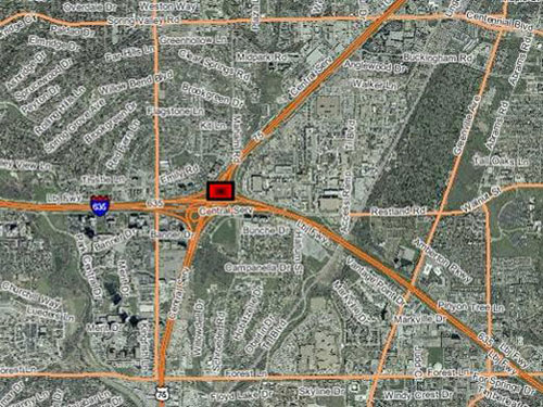
Figure 3.6-2 Incident Location on US-75 North of LBJ Freeway (Source: NCTCOG dfwmaps.com)
Assumptions:
The assumptions used for this scenario are:
- No Fatalities
- Hazardous materials spill due to at least 50 gallons of diesel fuel spilled
- Long-term closure requiring mode shift, and arterial diversions
- Multiple coordinated responses needed to optimize the corridor
Timeline:
| 6:00 a.m. | Incident Occurs, drivers immediately contact E911 to report the incident Due to integration with the various E911 CAD systems, the corridor agencies are immediately notified of the potential incident (through ICM System alerting subsystems) and approximate location (through ICM System mapping). |
| 6:10 a.m. | City of Richardson police arrive on scene and begin initial determination of severity and approximate time for resolution. TxDOT courtesy patrol and DART Motorist Assistance arrive on scene to assist with traffic control. TxDOT uses video cameras to verify type of incident and number of lanes closed, and notifies ICM partners. TxDOT, DART, and City of Richardson and Plano display preliminary information on their DMS signs north of the incident. |
| 6:20 a.m. | City of Richardson updates ICM System to indicate major incident with a closure of more than 4 hours. The corridor agencies are alerted through ICM alerting subsystem, and a previously approved response plan is recommended by the corridor Decision Support system. Local wrecker service has been notified, and begins response to assist police with clearing incident. |
| 6:30 a.m. | As part of the pre-planned response contained in the corridor Decision Support system, DART begins preparation for additional light rail and bus bridging for temporary parking. City of Richardson contacts local business close to light rail station to implement pre-agreed temporary parking. City of Richardson and City of Plano implement timing plans for freeway diversions. |
| 7:00 a.m. | emporary parking lots have been started; DMS signs and static trailblazer signs provide direction to motorists to these locations. DART has begun bus bridge between the temporary lots and light rail stations. City of Richardson and City of Plano have implemented bus signal priority. |
| 9:00 a.m. | HazMat response has begun to clean-up the fuel spill. The commercial vehicle has been up-righted, and clearance of boxes in roadway has begun. |
| 9:30 a.m. | Since majority of rush hour is completed, DART begins to reduce its light rail service back to normal levels. |
| 10:30 a.m. | Clearance of boxes has completed, and some capacity is restored to the freeway, interchange ramps have all re-opened. |
| 12:00 p.m. | Roadway is back to normal operation. |
| 8:00 p.m. | Bus Bridge ends for the temporary parking lots. |
Changes to Baseline Strategies:
The approach the US-75 Steering Committee has taken is to use the Daily Operations as the baseline for the strategies associated with the ICM, and then discuss what changes and additions are needed for the specific scenario. In the following tables, the stakeholders have identified some of the additional roles and responsibilities, and data and infrastructure required to have a corridor based response. In addition, the following changes to strategies were identified:
- Information sharing and distribution
- Operational efficiency at network junctions
- A common incident reporting system and asset management (GIS) system
- Modify transit priority parameters to accommodate more timely bus service and light rail service
- Emergency response signal priority
- En-route traveler information devices used to describe current operational conditions on another network(s) within the corridor
| Stakeholder | Roles and Responsibilities |
|---|---|
| Texas DOT |
Monitoring
Coordination
Information Distribution
|
| City of Richardson |
Monitoring
Coordination
Information Distribution
|
| City of Plano |
Monitoring
Coordination
Information Distribution
|
| DART |
Monitoring
Coordination
Information Distribution
|
Major Transit Incident
The US-75 Steering Committee discussed various potential scenarios for disruption of the transit network, and tried to decide upon location, time-of-day, and incident parameters. In order to capture the various response strategies for a major transit incident, multiple transit modes and impacts could be shown. Based on time-of-day, the impact and necessary strategies could be determined. Some of the scenarios discussed included outage due to strikes, train breakdown, rail shutdown, major crime event, surface street intersection incident involving light rail, morning in-bound transit scenario, and evening out-bound transit scenario – each of these would require different strategies and responses. A LRT train hitting a pedestrian during evening peak volume period was decided upon due to: the need to shut both directions of travel down; the relatively high frequency of actual DART LRT pedestrian accidents; and due to the evening peak volume that LRT customers who are already in Dallas not having the option of working from home – as would be the case for a morning peak event.
Incident Description:
A pedestrian is hit by a DART Red Line LRT light-rail train at 4:30 p.m. After reporting the incident to DART dispatch personnel, the train operator is directed to hold the train at the Lovers Lanes station until emergency response arrives. The pedestrian accident leaves the LRT train in a position that is not blocking surface street arterial lanes.
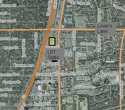
Figure 3.6-3 Incident Location in DART Red Line (Source: NCTCOG dfwmaps.com)
Assumptions:
- Minor impact to arterial network travel conditions, outside of 2 block vicinity of incident
- Little/no impact to freeway travel conditions
Timeline:
| 4:30 p.m. | Train operator radios pedestrian accident to DART dispatch, which then relays incident information and location to City of Dallas 911 dispatch. |
| 4:35 p.m. | Train ordered to remain in current location and exact location details are input into ICM System. DART and City of Dallas operators access TxDOT and City CCTV that are able to see incident scene and surrounding arterial network conditions. |
| 4:37 p.m. | Responders arrive on scene and begin relaying incident details, which are input into ICM system. DART enters incident information into DFW ATIS, and puts incident information out through vehicle and station DMS and PAs, as well as customer service and web trip planning services. |
| 4:45 p.m. | Incident responders relay that investigative operations will likely hold the train at current location and shutting down both directions of Red Line LRT for 2.5 hours. DART dispatch begins coordinating the transfer of Blue-Line LRT customers at the incident scene onto spare DART buses. Additionally, DART references ICM System Decision Support Tool for additional strategies based on modeling. Strategy of adding bus vehicles to adjacent lines, and beginning bus bridges to Red Line LRT are initiated. |
| 5:00 p.m. | City of Dallas sees DART bus lines have been increased and begins coordination for increased transit vehicle priority along City arterials. |
| 7:30 p.m. | DART verifies real-time ridership data and confirms ICM System Strategy to begin normal reduction in bus service due to time-of-day lower volumes. However, DART keeps the service higher than normal to accommodate for additional travelers using bus due to Red Line closure. |
| 8:15 p.m. | Incident investigative operations are finalized and Red Line LRT is reopened for travel. DART updates incident status in ICM System, as well as DFW ATIS. |
Changes to Baseline Strategies:
The approach the US-75 Steering Committee has taken is to use the Daily Operations as the baseline for the strategies associated with the ICM, and then discuss what changes and additions are needed for the specific scenario. In the following tables, the stakeholders have identified some of the additional roles and responsibilities, and data and infrastructure required to have a corridor based response. In addition, the following changes to strategies were identified:
- Information sharing and distribution
- Operational efficiency at network junctions
- A common incident reporting system and asset management (GIS) system
- Modify transit priority parameters to accommodate more timely bus service and light rail service
- Emergency response signal priority
- En-route traveler information devices used to describe current operational conditions on another network(s) within the corridor
- Modify transit priority parameters to accommodate more timely bus service
- Modify HOV restrictions (increase minimum number from 2 to 4)
- Increase roadway capacity by using shoulders for traffic (peak periods)
- Add transit capacity (express bus service during peak periods) by adjusting headways and number of buses
- Add temporary new transit service (bus bridge)
- Peak spreading by outreach to media/commuters on ridesharing and telecommuting during closure of the section of rail
| Stakeholder | Roles and Responsibilities |
|---|---|
| Texas DOT |
Monitoring
Coordination
Information Distribution
|
| City of Dallas |
Monitoring
Coordination
Information Distribution
|
| DART |
Monitoring
Coordination
Information Distribution
|
3.6.4. Weather Event Scenario
The US-75 Steering Committee discussed various potential scenarios for weather events, how likely they could occur, and tried to decide upon specific events that currently occur. In order to capture the various response strategies for different types of weather, the committee discussed how each event impacts their current systems, and how often these events occur. It was also decided that depending on the weather event, location of impacts, and time of day – different responses would be needed. In order to discuss the various potential responses, the following events were discussed:
Rain
Rain does occur frequently, and have a general impact to the flow of traffic; this includes transit, freeway, and arterials, which usually decreases the average speed and decreases throughput of the corridor. Rain also does provide some impact to traffic signal systems in some areas, and reduces the speed of the light rail system. Several locations within the corridor lose power to the traffic signals during heavy rain events, which can cause various response strategies to be implemented (re-routing, police manually doing traffic control, etc.)
The strategies and responses to this scenario would be a subset of minor and major arterial scenarios, minor incidents on transit, and minor incidents on freeways.
Ice
Ice storms do occur a couple times per year on average in Dallas, and have tremendous regional impact. Since these events do not occur often, the agencies within the region do not have the resources (plows, salt trucks, etc.) that some northern locations that routinely have snow and ice would have. This causes various issues and incidents. Many of the businesses in the region will shutdown during ice storms, and in general discourage travel during these events.
Similar to rain, overall speeds decrease significantly and throughput decreases. Also, incidents increase during this time on arterials and the freeway. One interesting side effect is also the impact on transit. The light rail system will sometimes be impacted due to ice that coats the power lines overhead of the vehicle and the contact between the vehicle and the power line is disrupted, causing shutdown of the vehicle. Overall, when discussing responses to this scenario, the committee focused more on the information needed and distributed to the public to try and reduce travelers during these events.
Ozone Alert / Action Day
Dallas is an air quality non-attainment area, and due to the heat during the summer months frequently has ozone alert and ozone action days. Part of the current response is to market heavily through the media, and ATIS systems. The committee also discussed the potential for using the ICM for additional mode shift to include increasing transit usage, and car pooling. Similar to a major freeway incident, temporary parking lots would be needed, to include bus bridges, and signal priority.
| Stakeholder | Roles and Responsibilities |
|---|---|
| Texas DOT |
Monitoring
Coordination
Information Distribution
|
| City of Dallas |
Monitoring
Coordination
Information Distribution
|
| City of Richardson |
Monitoring
Coordination
Information Distribution
|
| City of Plano |
Monitoring
Coordination Information Distribution
|
| DART |
Monitoring
Coordination
Information Distribution
|
| North Texas Tollway Authority |
Monitoring
Coordination
Information Distribution
|
| Town of Highland Park |
Monitoring
Coordination
Information Distribution
|
| City of University Park |
Monitoring
Coordination
Information Distribution
|
| North Central Council of Governments |
Monitoring
Coordination
Information Distribution
|