
Concept of Operations for the US-75 Integrated Corridor in Dallas, Texas

April 30, 2008
Award# DTFH-61-06-H-00040
4. ICM System Operational Concept
This chapter describes the Integrated Corridor Management System (ICM) operational concept for the US-75 Corridor in Dallas. The proposed ICM concept explains how things are expected to work once the ICM program and system are in operation, and identifies the responsibilities of the various stakeholders for making this happen. The chapter defines the ICM goals and objectives (Section 4.1); the operational approaches and strategies to be implemented in response to the Corridor problems and needs (Section 4.2); proposed changes to the current technical, operational, and institutional situation within the corridor (in essence, de facto "requirements") providing a sense of the overall scope for the ICM concept; alignment of the ICM with the Regional ITS Architecture (Section 4.6); and corridor performance measures and metrics (Section 4.9). The system concept also addresses the key system implementation issues including how they may be resolved (Section 4.7). An initial mapping (i.e., traceability) of each selected ICM strategy to the goal(s) and the corresponding need(s) it addresses is also included within the chapter. This chapter provides the traceability from vision, goals and objectives through to the assets and strategies that the US-75 Steering Committee discussed.
4.1. CORRIDOR GOALS AND OBJECTIVES
The Vision Statement for the Corridor, as stated in Section 3.10, is "Operate the US-75 Corridor in a true multimodal, integrated, efficient, and safe fashion where the focus is on the transportation customer." Using the Vision Statement as a starting point, the US-75 Steering Committee developed four primary Goals for the ICM, and discussed the Objectives and Strategies for each of the Goals. These Goals and Objectives, shown in Table 4.1-1 below, are interrelated such that activities and strategies oriented towards attaining one of the Goals will likely impact the attainment of other Goals and Objectives.
| Goals | Objectives |
|---|---|
Increase corridor throughput - The agencies within the corridor have done much to increase the throughput of their individual networks both from a supply and operations point of view, and will continue to do so. The integrated corridor perspective builds on these network initiatives, managing delays on a corridor basis, utilizing any spare capacity within the corridor, and coordinating the junctions and interfaces between networks, in order to optimize the overall throughput of the corridor. |
|
Improve travel time reliability - The transportation agencies within the corridor have done much to increase the mobility and reliability of their individual networks, and will continue to do so. The integrated corridor perspective builds on these network initiatives, managing delays on a corridor basis, utilizing any spare capacity within the corridor, and coordinating the junctions and interfaces between networks, thereby providing a multi-modal transportation system that more adequately meets customer expectations for travel time predictability. |
|
Improved incident management - Provide a corridor-wide and integrated approach to the management of incidents, events, and emergencies that occur within the corridor or that otherwise impact the operation of the corridor. The approach includes planning, detection and verification, response and information sharing, so that the corridor returns back to "normal" more quickly. |
|
Enable intermodal travel decisions - Travelers must be provided with a holistic view of the corridor and its operation through the delivery of timely, accurate and reliable multimodal information, which then allows travelers to make informed choices regarding departure time, mode and route of travel. In some instances, the information will recommend travelers to utilize a specific mode or network. Advertising and marketing to travelers over time will allow a greater understanding of the modes available to them. |
|
These corridor-wide Goals and Objectives have a general premise in the travelers' (i.e., "customers'") perspective of only one surface transportation system; and that the public generally is not concerned with which jurisdiction or agency is responsible for the road or transit network on which they are currently traveling. As taxpayers and fare/toll payers, they want and deserve a safe and reliable trip – one that provides a consistent level of service with minimal congestion, and is predictable in terms of travel time. Travelers also need accurate and timely information so that they can make informed decisions before and during trips. Table 4.1-2 maps these goals against the various corridor needs (as discussed in Chapter 3).
| Problems and Needs | Goals | |||
|---|---|---|---|---|
| Increase corridor throughput | Improve travel time reliability | Improved incident management | Enable intermodal travel decisions | |
| Corridor based approach among agencies and modes. |  |
|
|
|
| Improved coordination, cooperation and integration among stakeholders | |
|
|
|
| Improved interagency information sharing | |
|
|
|
| Improve demand balance among facilities | |
|
|
|
| Reduce non-recurring incidents | |
|
|
|
| Improve incident management process | |
|
|
|
| Data warehousing | |
|
|
|
| More standardization and system interoperability within and between all stakeholders | |
|
|
|
| Accurate real-time information on the operations of all network including travel time | |
|
|
|
| Improved operational coordination of networks in the corridor, particularly at junctions (including multi-modes) | |
|
|
|
| Accurate models to simulate corridor operation under various scenarios. | |
|
|
|
| Joint use of resources and infrastructure (e.g., service patrols, DMS) | |
|
|
|
| Improved in-reach and public outreach | |
|
|
|
| Funding sources for corridor initiatives including the O&M | |
|
|
|
| Increased transit usage | |
|
|
|
| Improved corridor wide incident management | |
|
|
|
| Performance measures for screening, monitoring and evaluating corridor-based strategies and operations | |
|
|
|
| Information Sharing both Inter-agency and with the Public | |
|
|
|
| Provide tools for Real-time operation of the system | |
|
|
|
4.2. USER NEEDS
User needs identify the high-level ICM system needs; these user needs are developed to focus on the operational aspects of the ICM, and defining the functional requirements of the proposed ICM system. These needs are based upon the system goals and objectives provided above, and the future operational conditions and scenarios defined in Section 5. The user needs will be utilized during the requirements development of the next phase of the systems engineering process to develop the high-level system requirements document.
4.2.1. Use Cases
Use cases are a technique for capturing the functional requirements of a system. Use cases work by describing the typical interactions between the users of a system and the system itself, by providing a narrative of how a system is used.
Utilizing the scenarios developed during the concept of operations phase of the ICM project, use cases were developed to tie the scenarios together by a common user goal. The goal of the typical user (traveler) is to make a trip from one location to another. This trip requires the user to plan, understand the current conditions of the transportation network, and make changes during the trip if the conditions of the network change. In use case terminology, the users are referred to as actors. An actor is a role that a user plays with respect to the system. Actors might include travelers, agency operators, or the ICM steering committee. Actors carry out use cases. A single actor may perform many use cases; conversely a use case may have several actors performing it.
There are three key things we need to know to describe a use case:
- The actor or actors involved. An actor is a type of user (for example, traveler) that interacts with the system.
- The system being used.
- The functional goal that the actor achieves using the system the reason for using the system.
There's a little more to it than that, for example if we were developing a use case for an Automated Teller Machine:
- The actor describes a role that users play in relation to the system. Maybe the cardholder is an advertising executive, but that doesn't interest us. We only care about his relationship to the system.
- The actor is external to the system itself.
- Actors don't have to be people. They can be other systems. For example, the ATM may need to connect to the cardholder's bank. External systems that interact in a use case are also actors.
- The goal must be of value to the actor. We wouldn't have a use case called Cardholder enters PIN because that, by itself, has no value to the cardholder. We don't build ATM's just so people can enter their PINs!
When we are analyzing functional requirements for a system, the key questions we need to ask are; who will be using the system, and what will they be using it to do?
In order to develop the user needs and functional requirements of the ICM system, a Use Case diagram was developed to show the ICM system and all of its actors and use cases (at a high level.) The actual use case descriptions and content will be provided in the requirements document during the next phase.
During the high-level requirements development, each Use Case will be expanded upon to discuss the dependencies, interfaces, and conditions.
4.2.2. User Needs Development
These needs were established through a dedicated Corridor Stakeholder interviewing process, as well as by general input throughout the process of developing this Con Ops. Utilizing the Use Cases from the section above, User Needs were developed. The following needs represent the identified needs of the ICM system.
| Need # | Need Title and Description |
|---|---|
| 1 | Need for improved communication among agencies – to ensure that actions taken by one corridor agency do not have unintended consequences on the corridor, or other agencies within the corridor, the agencies need to communicate interactively with each other in order to plan and execute actions that are not normal operation procedures. The communication does not have to be continuous, but does need to occur in a timely manner when actions are about to begin. |
| 2 | Need to monitor the status of the physical transportation infrastructure – The agency operators need to monitor the status of all devices within the corridor on a real-time or near real-time basis. Knowing which devices are operational will enable them to determine which devices can be used to affect change within the corridor. |
| 3 | Need to process information on status of the infrastructure in near-real time – The ICM system needs to be able to process all of the relevant data and information it receives from the various agencies within the corridor, in order to provide information to operators and travelers which can be used to make informed decisions on actions to be made. |
| 4 | Need to update conditions of the infrastructure to the public and other agencies in near-real time – in order to optimize the corridor operations, the travelers and the agencies need to have up to date information on the current conditions and status of the corridor infrastructure. |
| 5 | Need for interactive trip planning – to ensure that travelers within the corridor can make informed decisions, the corridor agencies need to provide a way to allow travelers to develop plans for a trip. This could include various media, and multi-modes of travel. |
| 6 | Need for near-real time information for travelers – in order to optimize the trips that a traveler makes, they need to have current information provided to them during trips in order to make informed decisions on the their current route and mode. |
| 7 | Need to have physical infrastructure coverage – The components for the physical infrastructure (DMS, CCTV, communications network, etc.) within the corridor need to be reliable, available, maintained, extensible, and interoperable. The operators of the corridor need to know the location of all devices and other facilities within the corridor's network, and their purpose and capabilities. If a device is not operating correctly, the operator needs to know whom to contact to fix the device. |
| 8 | Need to collect and store data/ information – The data/ information collected during daily operations of the corridor needs to be stored for analyzing the effectiveness of the corridor strategies and responses, and for modeling. |
| 9 | Need to provide pre-agreed incident response plans – The agencies in the corridor need to have some pre-arranged response plans for incidents within the corridors, these will provide the contacts, roles and responsibilities, and responses for each network within the corridor. |
| 10 | Need to coordinate incident responses among agencies – The agencies within the corridor need to coordinate responses to incidents such that two agencies are not responding to the same incident, and not inadvertently impacted one another. |
| 11 | Need to provide multi-modal alternatives for travelers – In order to reduce congestion, and improve efficiency of the entire corridor, multiple modes and routes need to be available to the traveler. These modes choices need to include alternatives for various levels of income and mobility for the traveler. |
| 12 | Need to measure effectiveness of responses – During the response to an event in the corridor, the operators need to be able to determine if the pre-planned response is effective and if the response if having the intended effect. This includes verifying what conditions exist after implementation of a response. If the operators of the systems determine that their response is not effective, they should be able to change components of their response plans and communicate these changes to the other agencies within the corridor, such that they are not inadvertently impacting the other agencies. |
| 13 | Need to modify responses during event as conditions change – As an event progresses, the conditions (such as lanes closed, severity, etc.) will change. The operators should be able to modify the current conditions, and communicate with the others within the corridor of the change. The system needs to also request changes to the current responses as the conditions warrant. |
| 14 | Need to request use of infrastructure from third party – During some major incidents and special events, the current and planned capacity of the infrastructure owned and operated by the agencies may not be sufficient. This requires an interface to multiple third parties (large companies, private parking, van services, etc.) to request service from them or use of their infrastructure during special circumstances. |
4.3. APPLICATION OF ICM APPROACHES AND STRATEGIES
In order to determine the Strategies to meet the needs, goals, and objectives of the US-75 Corridor Stakeholders, several meetings and workshops were completed to ensure that all Stakeholder viewpoints were relayed and considered in the decision-making process by the project US-75 Steering Committee. The activities that were completed as part of developing this Con Ops included:
- Meeting with each Stakeholder agency individually to discuss the US-75 Corridor, the agency's needs and potential Strategies for meeting the goals
- Multiple project US-75 Steering Committee meetings / workshops to review the findings of the agency meetings, and to the discuss goals and strategies for the US-75 Corridor ICM
Overall, the Strategies for meeting the goals agreed to by the US-75 Steering Committee fit very well with many of the activities already underway in the Dallas Region. From the ICM Strategies discussed, the US-75 Steering Committee discussed multiple scenarios to decide upon the institutional framework for the corridor, and to ensure that all goals and Strategies were documented. The US-75 Steering Committee participated in multiple workshops and discussed and evaluated each of the scenarios and Strategies for the corridor with respect to their potential for achieving the goals, objectives, and needs of the corridor and stakeholders. As this analysis evolved, the following scenarios were addressed:
- Daily Operations (including minor incidents)
- Major Incidents
- Freeway
- Arterial
- Transit Incident
- Weather Event
These scenarios and the goals, objectives, and needs of the corridor also guided the selection of the ICM Strategies for the US-75 Corridor, which are shown in Table 4.3-1 by Goal.
| Goal | Proposed ICM Approach and Strategies |
|---|---|
| Increase corridor throughput |
|
| Improve travel time reliability |
|
| Improved incident management |
|
| Enable intermodal travel decisions |
|
As previously noted, the ICM Strategies selected by the US-75 Steering Committee and Stakeholders were developed based on how each goal could be met through Integrated Corridor Management System deployments and initiatives. Since there were many commonalities among the Strategies identified, an analysis was executed to ensure that Strategies for one goal did not compete or contradict with other Strategies for the corridor. The resultant Corridor ICM strategy (or approaches) grouping is shown in Table 4.3-2. The bulleted text are the high-level strategies developed by USDOT and provided in their documentation, the dashed bullets are sub-strategies that the US-75 Steering Committee provided as strategies and actions they need to make the ICM successful. The sub-bullets identify areas of consideration the stakeholders considered important for the corridor.
| Proposed ICM Approach and Strategies |
|---|
Information Sharing/ Distribution
Improve Operational Efficiency
Accommodate / Promote Cross-Network Route & Modal Shifts
Manage Capacity–Demand Relationship – Real-time / Short-Term
Manage Capacity–Demand Relationship – Long-Term Capacity Oriented
Demand-Oriented
|
The Strategies decided upon by the US-75 Steering Committee were selected based upon achieving the goals of the Corridor, and of the individual Stakeholders within the Corridor. A high-level outline of Strategy relationship to the corridor goals is provided in Table 4.3-3, presented below.
In order to be consistent with US DOT terminology, the US-75 Corridor Strategies identified in Table 4.3-2 were mapped to the high-level strategies provided by the US DOT in the Generic ICM Con Ops document. These Strategies were grouped into five categories. The first grouping, Information Sharing/ Distribution, provides the information foundation for the corridor. Many of the Strategies are already in existence within the corridor, but need to be expanded throughout the Corridor agencies and communized. The existing Center-to-Center communication infrastructure provides the basis for interagency and intra-agency communication. The regional ATIS system hosted by the NCTCOG website provides a baseline for a corridor web-based ATIS system. As with most major cities, this information is also provided to 3rd party information service providers and combined with their value-added information to provide additional recommendations and traveler information. One of the important parts of this strategy is the use of modeling to provide decision support tools and for monitoring the ongoing performance measures of the corridor for the agencies. The decision support tools will model the individual networks, and model the potential and historical mode shifts within the corridor.
The second grouping, "Improve Operational Efficiency" approach will provide some needed expansions in the corridor to improve operations. These strategies will improve the travel reliability and corridor throughput, both of which are goals of the US-75 Corridor.
The third grouping, "Accommodate / Promote Cross-Network Route & Modal Shifts" will assist in optimizing the overall corridor throughput and will assist the agencies within the Corridor to better manage congestion and improve the overall reliability of the network. A major component of this strategy is to ensure that the public is aware of all modes and travel choices within the Corridor, such that they can plan their trips using current information within the network.
The fourth grouping, "Manage Capacity – Demand Relationship" approach provides the strategies necessary to make the public aware of their choices in modes, thus improving corridor capacity and potentially reducing or moving the demand. These strategies include public outreach to employers to assist with spreading out the daily demand on the network, and reducing demand during special events and emergencies.
The last grouping, "Manage Capacity – Demand Relationship – Long-Term" are strategies that will be done over a longer period of time, and include "re-training" the public to think about the alternate modes.
| ICM Strategy | Increase corridor throughput | Improve travel time reliability | Improved incident management | Enable intermodal travel decisions |
|---|---|---|---|---|
| Information Sharing/ Distribution | |
|
|
|
|
 |
|
|
|
|
|
|
|
|
|
|
|
|
|
|
|
|
|
|
|
|
|
|
|
|
|
|
|
|
|
|
|
|
|
|
|
|
|
|
|
|
|
|
|
|
|
|
|
|
| Improve Operational Efficiency | |
|
|
|
|
|
|
|
|
|
|
|
|
|
|
|
|
|
|
|
|
|
|
|
|
|
|
|
|
|
|
|
|
|
|
|
|
|
|
|
|
|
|
|
| Accommodate / Promote Cross-Network Route & Modal Shifts | |
|
|
|
|
|
|
|
|
|
|
|
|
|
|
|
|
|
|
| Manage Capacity–Demand Relationship – Real-time / Short-Term | |
|
|
|
|
|
|
|
|
|
|
|
|
|
|
|
|
|
|
|
|
|
|
|
|
|
|
|
|
|
|
|
|
|
= Directly Supports Goal
= Indirectly Supports Goal
4.4. ICM CONCEPT ASSET REQUIREMENTS AND NEEDS
In order to better understand the asset requirements and needs, the US-75 Steering Committee organized the Strategies based upon the segment of transportation that was impacted, this included 5 categories: arterial, freeway, tollway, transit, and overall corridor. Table 4.4-1, below, shows these Strategy groupings organized by network utilizing the Strategy categories provided in the Generic Concept of Operations, which are used to look at the asset needs of the individual Networks. This section identifies the assets required to implement and support the various strategies, as defined in the National ITS Architecture and the Generic Concept of Operations. The list of assets shown in Table 4.4-2 below does not consider whether these assets currently exist.
| Arterial Network Strategies |
|---|
Information Sharing / Distribution
Improve Operational Efficiency
Accommodate / Promote Cross-Network Route & Modal Shifts
Manage Capacity–Demand Relationship – Real-time / Short-Term
Manage Capacity–Demand Relationship – Long-Term
|
| Freeway Network Strategies |
Information Sharing / Distribution
Improve Operational Efficiency
Accommodate / Promote Cross-Network Route & Modal Shifts
Manage Capacity–Demand Relationship – Real-time / Short-Term
Manage Capacity–Demand Relationship – Long-Term
|
| Tollway Network Strategies |
Information Sharing / Distribution
Improve Operational Efficiency
Accommodate / Promote Cross-Network Route & Modal Shifts
Manage Capacity–Demand Relationship – Real-time / Short-Term
Manage Capacity–Demand Relationship – Long-Term
|
| Transit Network Strategies |
Information Sharing / Distribution
Improve Operational Efficiency
Accommodate / Promote Cross-Network Route & Modal Shifts
Manage Capacity–Demand Relationship – Real-time / Short-Term
Manage Capacity–Demand Relationship - Long-Term
|
| Overall Corridor Strategies |
Information Sharing / Distribution
Improve Operational Efficiency
Accommodate / Promote Cross-Network Route & Modal Shifts
Manage Capacity–Demand Relationship – Real-time / Short-Term
Manage Capacity–Demand Relationship – Long-Term
|
In Table 4.4-2, below, the categories and definitions provided in the US DOT Concept of Operations for a Generic Corridor were used to further define the US-75 Corridor ICM assets. These categories are defined as follows:
- Network Systems – These are the required network-based systems. They are identified by the National ITS Architecture nomenclature of "Market Package" for ease of reference to functionality.
- Network Subsystems & Technologies – This column provides additional information on these minimum network ITS-based requirements (e.g., specific field devices, hardware, and system functionality).
- Information – This column lists the data and other information to be gathered by the network systems, and subsequently shared among the stakeholders and corridor travelers.
- Communication Subsystems – These assets are communications – related, including the types of communications (e.g., center-to-center) as identified in the National ITS Architecture, interfaces to systems, and associated ITS standards.
- Other/Performance – This column is used for other ICM – required assets that don't "fit" into the other categories, such as the few regional/multi-system market packages, institutional assets (responsibilities and policies), and support tools.
| Network Systems (Market Packages) | Network Subsystems & Technologies | Information | Communication Subsystems | Other (Operational) / Performance |
|---|---|---|---|---|
Network / Probe Surveillance Surface Street control Freeway Control HOV Lane Management Traffic Information Dissemination Traffic incident Management Traffic Forecast & Demand Management Emissions Monitoring / Management Parking Facility Management Roadway Closure Management Transit Vehicle Tracking Transit Fixed Route Operations Transit Passenger and Fare Management Transit Traveler Information ISP Traveler Information (broadcast, interactive, route guidance) HAZMAT Management Emergency Call Taking and Dispatch Emergency Routing Roadway Service Patrols Transportation Infrastructure Protection Early Warning Wide Area Alert Disaster Response & Recovery Evacuation & Re-entry Management Disaster Traveler Information ITS Data Mart / Warehouse Maintenance / Construction Vehicle & Equipment Tracking Road Weather Data Collection Weather Information Processing and Distribution Work Zone Management Maintenance & Construction Activity Coordination Other (e.g., Asset Management System) |
Traffic detectors / roadway surveillance / vehicle probes CCTV (video surveillance) Traffic signal control / monitoring (TOD schedule) Traffic signal control / monitoring (traffic adaptive) HOV by-pass DMS – freeway DMS - arterials Internet Traveler Information Automated Incident Detection Incident Detection (call-in, other) Incident Response Plans / Guidelines Teams Incident Reporting System (GIS, common display) Air quality sensors Road Weather Information Sensors Parking Surveillance/ occupancy Transit Vehicle Location / GPS Transit Schedule Performance Monitoring Passenger Counting Equipment Electronic Fare / Parking Payment Equipment DMS – transit Transit Public Address System Transit Trip Planning System Spare transit vehicles / operators Telephone-Based ATIS (511) Transit priority equipment (Intersection & Transit Vehicles) Public Safety CAD Emergency vehicle priority / preemption (Intersection / Vehicles) Service Patrol Vehicles Real-time conditions data base / common displays Maintenance Vehicle Location AVL / GPS |
Roadways (Freeway, Arterial, Managed Lanes)
Transit
Equipment / Device Status
Other
|
Center-to-Center Center to field Roadside to vehicle Center to vehicle ITS standards for data formats and data transfer functions Video transport standards (digital, analog) Voice communications Subsystem Capacity for data distribution Subsystem Capacity for video distribution Subsystem capacity / frequencies for voice communications (including interoperability) Interfaces to network systems Interfaces to emergency service systems (CAD) Interfaces to proprietary / legacy systems Interfaces to ISP's (data and video export) Interfaces to financial transaction network Interfaces to Internet Security firewalls |
Regional Traffic Control (MP) Regional Parking Management (MP) Multi-Modal Coordination (MP) Regional / Sub-regional ITS Architecture Information Exchange Network / Common displays for data entry/display Data aggregation / storage of processed data for subsequent analysis Availability of spare network capacity Corridor Models (simulation) Accuracy of data/information Vehicle location accuracy Surveillance coverage Response plans On-line decision support (for selecting response plans) Definitions of responsibilities of agencies Common policies for incident reporting and response Special Event Plans Common fare collection technology Integrated back office systems Dynamic fare pricing capability Priority logic at intersections System back up / disaster recovery |
4.5. COMPARISON OF ICM ASSET REQUIREMENTS WITH CURRENT / PROPOSED ASSETS
Using the information from Chapter 3 on current and proposed corridor assets and information collected during stakeholder interviews, a comparison was performed with the list of assets needed to support the ICM concept. Table 4.4-2 was revised to highlight assets that are already operating within the corridor or are potential assets based on current improvement plans. The US-75 Steering Committee, as part of the scenario development, also identified data and infrastructure needs. The results are shown in Table 4.5-1 using the following:
- Bold Type and Gray Highlight – The asset is essentially deployed throughout the Corridor, except for the necessary integration among the corridor stakeholders.
- Underline – The asset is only partially deployed within the Corridor.
- None – Minimal, if any, deployment of the asset within the Corridor.
| Network Systems (Market Packages) | Network Subsystems & Technologies | Information | Communication Subsystems | Other (Operational) / Performance |
|---|---|---|---|---|
Network / Probe Surveillance Surface Street control Freeway Control HOV Lane Management Traffic Information Dissemination Traffic incident Management Traffic Forecast & Demand Management Emissions Monitoring / Management Parking Facility Management Roadway Closure Management Transit Vehicle Tracking Transit Fixed Route Operations Transit Passenger and Fare Management Transit Traveler Information ISP Traveler Information (broadcast, interactive, route guidance) HAZMAT Management Emergency Call Taking and Dispatch Emergency Routing Roadway Service Patrols Transportation Infrastructure Protection Early Warning Wide Area Alert Disaster Response & Recovery Evacuation & Re-entry Management Disaster Traveler Information ITS Data Mart / Warehouse Maintenance / Construction Vehicle & Equipment Tracking Road Weather Data Collection Weather Information Processing and Distribution Work Zone Management Maintenance & Construction Activity Coordination Other (e.g., Asset Management System) |
Traffic detectors / roadway surveillance / vehicle probes CCTV (video surveillance) Traffic signal control / monitoring (TOD schedule) Traffic signal control / monitoring (traffic adaptive) Ramp Meters (local control) Ramp Meters (central control) HOV by-pass DMS – roadway Internet Traveler Information Automated Incident Detection Incident Detection (call-in, other) Incident Response Plans / Guidelines Teams Incident Reporting System (GIS, common display) Air quality sensors Road Weather Information Sensors Parking Surveillance/ occupancy Transit Vehicle Location / GPS Transit Schedule Performance Monitoring Passenger Counting Equipment Electronic Fare / Parking Payment Equipment DMS – transit Transit Public Address System Transit Trip Planning System Spare transit vehicles / operators Telephone-Based ATIS (511) Transit priority equipment (Intersection & Transit Vehicles) Public Safety CAD Emergency vehicle priority / preemption (Intersection / Vehicles) Service Patrol Vehicles Real-time conditions data base / common displays Maintenance Vehicle Location AVL / GPS |
Roadways (Freeway, Arterial, Managed Lanes)
Transit
Equipment / Device Status
Other
|
Center-to-Center Center to field Roadside to vehicle Center to vehicle ITS standards for data formats and data transfer functions Video transport standards (digital, analog) Voice communications Subsystem Capacity for data distribution Subsystem Capacity for video distribution Subsystem capacity / frequencies for voice communications (including interoperability) Interfaces to network systems Interfaces to emergency service systems (CAD) Interfaces to proprietary / legacy systems Interfaces to ISP's (data and video export) Interfaces to financial transaction network Interfaces to Internet Security firewalls |
Regional Traffic Control (MP) Regional Parking Management (MP) Multi-Modal Coordination (MP) Regional / Sub-regional ITS Architecture Information Exchange Network / Common displays for data entry/display Data aggregation / storage of processed data for subsequent analysis Availability of spare network capacity Corridor Models (simulation) Accuracy of data/information Vehicle location accuracy Surveillance coverage Response plans On-line decision support (for selecting response plans) Definitions of responsibilities of agencies Common policies for incident reporting and response Special Event Plans Common fare collection technology Integrated back office systems Dynamic fare pricing capability Priority logic at intersections System back up / disaster recovery |
The US-75 Corridor is currently operated in a mostly agency specific way, instead of a coordinated corridor basis. The corridor agencies and the region have many of the assets needed to implement ICM, however further integration and coordinated response plans are needed. Some coordination does currently occur during special events and major incidents. Also, some integration is already in place. For instance, both the DART HOV operations and the TxDOT Freeway operations are co-located at a satellite TMC, and will be co-located in the new DalTrans facility once it is completed.
As can be seen by Table 4.5-1 above, numerous assets need to be implemented in order to carry out the US-75 Corridor ICM Strategies. The most significant asset needs for the stakeholders of the US-75 ICM are provided in Table 4.5-2, below. As discussed above, the current assets within the corridor provide for a significant foundation for the US-75 ICM. Integration of available data for Corridor Stakeholders is already begun and many of the assets required for ICM are already in place. However, as in most metropolitan areas with significant ITS deployment, expansion of existing systems is needed and additional data collection assets are required for the US-75 ICM to meet its full potential.
The assets and processes that are needed for a more integrated corridor will be prioritized and accounted for when the high-level and detailed level requirements and designs are developed in the future as a part of the systems engineering process. A key component of this prioritization is the corridor models that are in development. As described later in Section 4, the corridor plans to develop multiple microscopic, macroscopic and mesoscopic models for the corridor that will be utilized to model the various strategies and scenarios. These models will be utilized by the committee to review and analyze the proposed strategies, to determine which strategies have the best benefit/ cost ratio for the corridor and are technologically feasible with the existing systems.
| Organizational Entity | Changes and Additions |
|---|---|
| Texas Department of Transportation (TxDOT) |
|
| City of Dallas |
|
| City of Richardson |
|
| City of Plano |
|
| Dallas Area Rapid Transit (DART) - Bus Service |
|
| Dallas Area Rapid Transit (DART) - Rail Service |
|
| Dallas Area Rapid Transit (DART) |
|
| North Central Texas Council of Governments |
|
| North Texas Tollway Authority |
|
The ICM concept represents a paradigm shift for management and operations within the Generic Corridor – from the current partial coordinated operations between corridor networks and agencies, to a fully integrated and pro-active operational approach that focuses on a corridor perspective rather than a collection of individual (and relatively independent) networks. To make this happen, several implementation and integration issues must be resolved. Several of these implementation issues will involve choices that cannot be fully addressed and subsequently resolved until later stages of the systems engineering process (e.g., design, procurement, and implementation).
4.6. CORRIDOR CONCEPT OPERATIONAL DESCRIPTION
Keeping in mind the vision of the ICM project, "Operate the US-75 Corridor in a true multimodal, integrated, efficient, and safe fashion where the focus is on the transportation customer", the management and operations of the corridor and the ICM will be a joint effort involving all the stakeholders. The management and operations of the corridor and the ICM will be a joint effort involving all the stakeholders. To effectively manage and operate the ICM concept as described in this Con Ops document, the US-75 Steering Committee recommends the creation of a central corridor decision-making body. This body – designated as the US 75 ICM Subcommittee – will consist of leadership level representatives from each of the stakeholders in the US-75 Corridor. Due to the number of agencies involved in ITS and traffic operations in the Dallas-Fort Worth Region, the subcommittee is envisioned to be a subcommittee of the Regional ITS Steering Committee. The membership will consist of members from each of the corridor agencies; however, membership will be on a rotational basis so that the size doesn't become too large.
The daily operation of the corridor will be coordinated through the existing arrangements and information will be exchanged through the center-to-center project, along with a Decision Support system which will distribute response plan requests and utilize the center-to-center interface to communicate to the various agency systems. The central point of coordination for the corridor will be the DalTrans facility, with TxDOT, Dallas County, and DART co-located at the facility.
All operations among corridor networks and agencies (e.g., activation of specific ICM strategies) will be coordinated via the Decision Support system. The US 75 ICM Subcommittee will also investigate and prepare corridor response plans for various scenarios that can be expected to occur within the US-75 Corridor. The chairman of the committee will be responsible, with the other agency/service operations officers, for configuring the subcommittee with respect to its functions and staffing for all hours of operations. Staff will be assigned by the corridor stakeholders to support daily operations, develop response plans, analyze system deficiencies and needs, and general administration. Performance measurement and monitoring will be the responsibility of the US 75 ICM Subcommittee. The agency/service members, led by the chief chairman, will be accountable to the centralized decision-making body and make reports as the decision-making body designates.
Communications, systems, and system networks will be integrated to support the virtual corridor command center. Voice, data, video, information, and control will be provided to all agencies based on the adopted protocols and standards for the sharing of information and the distribution of responsibilities. The ICM will support the virtual nature of the corridor by connecting the member agency staff on a real-time basis via communications and other ITS technologies. While all the ICM operational strategies will be available for use, it is envisioned that only a subset of these strategies will be activated at any one time, depending on the operational conditions and events within the corridor.
The US 75 ICM Subcommittee, working with NCTCOG will conduct desktop scenario sessions to prepare, train and refine response plans for incidents, special events, weather, and evacuations. All the agency/service operations officers and staff will know their respective roles and responsibilities for any of the various situations the corridor may face and will be aided by the Decision Support system and the evaluation model results. Moreover, agency operations officers will be able and authorized to improvise as situations may dictate.
Traveler information via websites, DMS, and through the media and ISPs will be corridor-based, providing information on corridor trip alternatives complete with current and predicted conditions. Travelers will access or be given real-time corridor information so they can plan or alter their trips in response to current or predicted corridor conditions. Each traveler will be able to make route and modal shifts between networks easily due to integrated and real-time corridor information, integrated fare/parking payment system, and coordinated operations between networks. Using one network or another will be dependent on the preferences of the traveler, and not the nuances of each network. Travelers will be able to educate themselves about the corridor so they can identify their optimal travel alternatives and obtain the necessary tools to facilitate their use of corridor alternatives when conditions warrant.
The US-75 Corridor will be an integrated transportation system – managed and operated collectively – to maximize its efficiency to corridor travelers. All corridor assets will be attuned to obtain the goals and objectives of the corridor, as well as the goals of each individual traveler as their preferences prescribe. The corridor users will recognize the US-75 Corridor as a multimodal, integrated, efficient, and safe transportation system that provides them with multiple viable alternatives that they can select based on their specific travel circumstances and needs.
4.7. ALIGNMENT WITH REGIONAL ITS ARCHITECTURE
As discussed in 3.7 above, the North Central Texas Council of Governments maintains the Regional Architecture for the Dallas-Fort Worth Region, which the US-75 Corridor is a portion. The Regional Architecture and ITS Plan for the Dallas-Fort Worth was defined in 1999. The Regional ITS Plan is currently being updated, and should be completed soon. The goals and strategies for the Regional ITS Architecture are very similar to the strategies and integration needed for the US-75 Integrated Corridor Management System.
A review of the existing Regional Architecture and ITS Plan found that many of the goals were the same. The findings of this review are:
- Increase Corridor Throughput – this goal is in line with the goals of "Enhance mobility of people and goods by reducing recurrent traffic congestion", and
- Improve travel time reliability
- Improved incident management
- Enable intermodal travel decisions
The Major focus of the Corridor and the Region is increased and timely information sharing among agencies and the public. This has already been started through various projects and initiatives to include a Regional ITS website which provides Real-time Traveler Information, and through the Center-to-Center project which provides Standards based information sharing among agencies in the Dallas-Fort Worth Region, and among agencies in the US-75 Corridor.
Other deployment considerations:
- Fill gaps in the existing ITS communications infrastructure by completing critical system linkages
- Leverage transportation resources by targeting investment, where possible, to facilities undergoing reconstruction
- Leverage transportation resources by creating or enhancing public/private partnerships which will provide communications infrastructure for regional ITS
- Provides transportation service or transportation data that is regional in scope.
4.8. IMPLEMENTATION ISSUES
As part of the on-going discussions of strategies and scenarios, several implementation issues were identified. These implementation issues are both technical and political in nature. The technical issues deal with the limitations of technology, and traffic flow. The political issues deal with existing policies and budget issues. Table 4.8-1, below, identifies the main issues that were identified during the committee discussions.
| Issue / Limitation | Potential Impact |
|---|---|
| Transit Headway – maximum headway of light rail trains is 2 minutes | Limited increase in Light Rail capacity may be insufficient for major mode shift during major incidents and special events. |
| Light Rail – Train has maximum length of three cars due to the rail station length | Limited increase in Light Rail capacity may be insufficient for major mode shift during major incidents and special events. |
| Diversion Policies – several of the agencies have policies against diverting traffic from freeway to arterial streets | Full Corridor optimization may not be possible without some changes in current policies. |
| Detour Route Policies – several of the agencies have policies against specifying specific detour routes | Full Corridor optimization may not be possible without some changes in current policies. |
| Modeling requirements - Due to the complex nature of the ICM initiative, the committee has looked at the modeling effort as a prerequisite to prioritizing and finalizing the strategies for ICM. | Many strategies chosen initially may be found through modeling to have little to no positive effect on the corridor |
| Hours of Operations - Many of the City agencies have limited hours of operations due to funding issues. | Response to some corridor scenarios will be time limited in off-hours. |
| Coordination and delegation of authority – some agencies will not allow modification or control of their assets by others. | Responses to some scenarios will require more coordination and may increase time for response. |
| Resource Requirements – many of the operating agencies do not have the additional resources that may be needed for a corridor operation approach | Resources identified in the Design phase may not be available from some agencies. |
4.9. CORRIDOR ICM CONCEPT INSTITUTIONAL FRAMEWORK
In developing the institutional framework, the US-75 Steering Committee considered many configurations and institutional arrangements to continue and improve upon a de-centralized operational model with a centralized decision making body for cooperation and oversight. The concept presented herein represents the institutional framework endorsed by the US-75 Steering Committee. The approach for the US-75 Corridor is to utilize existing institutional cooperation agreements, and expand on them specifically for the corridor.
The management and operations of the corridor and the ICM will be a joint effort involving all the stakeholders. To effectively manage and operate the ICM concept as described in this Con Ops document, the US-75 Steering Committee recommends the creation of a central corridor decision-making body. This body – designated as the US 75 ICM Subcommittee – will consist of leadership level representatives from each of the stakeholders in the US-75 Corridor. Due to the number of agencies involved, the subcommittee is envisioned to be a subcommittee of the Regional ITS Steering Committee. The membership will consist of members from each of the corridor agencies; however, membership will be on a rotational basis so that the size doesn't become too large.
The elected officials for the region are members of the Regional Transportation Council, which provides direction and policy decisions for the members of the US 75 Corridor. A formal recognition of the US 75 ICM Subcommittee will be requested, and a committee charter created to outline its goals. It is envisioned that the US 75 ICM Subcommittee will be a subcommittee of the existing regional ITS Steering Committee.
The US 75 ICM Subcommittee will be the central decision-making body for the corridor, managing the distribution of responsibilities, the sharing of control, and related functions among the corridor agencies. The US 75 ICM Subcommittee will be responsible for establishing the necessary inter-agency and service agreements, budget development, project initiation and selection, corridor operations policies and procedures, and overall administration. It is envisioned that the US 75 ICM Subcommittee will be the next generation of the US 75 ICM Committee established for this project.
The US-75 Steering Committee discussed how the corridor would be managed from an institutional point of view, and in keeping with the current plans for the region. Since both TxDOT and DART will be operating from the DalTrans advanced transportation management center, and will continue to be connected to the City of Dallas and the City of Richardson, it will serve as the central point of coordination for the US-75 Corridor.
The proposed institutional framework for the US-75 Corridor as described above is shown in Figure 4.9-1. The US-75 Corridor staffing is summarized in Table 4.9-1.
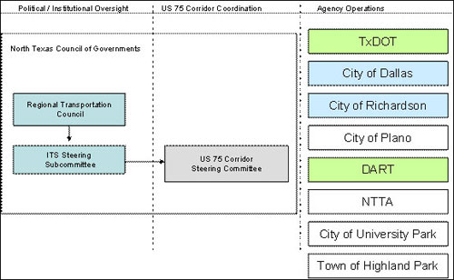
Figure 4.9-1 US 75 ICM Institutional Framework
| Agency/Service | Responsibilities | Aligned Staff |
|---|---|---|
| US 75 Corridor Steering Committee |
|
|
| TxDOT |
|
|
| City of Dallas |
|
|
| City of Richardson |
|
|
| City of Plano |
|
|
| DART |
|
|
| NTTA |
|
|
| Town of Highland Park |
|
|
| City of University Park |
|
|
| NCTCOG |
|
|
The existing US-75 Steering Committee agreed that this is the best framework to facilitate the implementation and operations of this US-75 ICM Corridor. The US-75 Steering Committee has the endorsements of each stakeholder representative's agency/service leadership to pursue the creation of this institutional framework. As the project moves from concept to the design stage, formal inter-agency agreements will be developed and executed describing this institutional framework and structure in detail, including each agency's responsibilities.
4.10. PERFORMANCE MEASURES
As part of the workshops identifying goals and strategies, the US-75 Steering Committee discussed how the goals could be measured effectively and with the data available. These corridor performance measures are identified in Table 4.10-1. The US-75 Steering Committee also acknowledges that as the corridor system matures and operational experience is gained, these performance measures will likely change as new collection methods and processing techniques are implemented.
| Goal | Potential Performance Measure |
|---|---|
| Increase corridor throughput |
|
| Improve travel time reliability |
|
| Improved incident management |
|
| Enable intermodal travel decisions |
|
Each individual network will be responsible for collecting network-specific data related to each of the designated corridor performance measures and providing these network level data to the ICMS for processing and aggregation. The ICMS will in turn save data to the regional data warehouse for archiving.
Taking into account the vision, goals, and current conditions within the corridor, the US-75 Steering Committee discussed "success" targets for several of the performance measures, their main concern was if the target was realistic, could be measured, and if enough data would be available. These "Performance Measures Success Thresholds," listed in Table 4.10-2, provide an indication that the corridor goals have been achieved. The listed performance levels/thresholds are long-term targets that reflect the future vision of how the corridor will operate. Upon deployment of the ICM, any movement toward the thresholds will indicate that ICM is having the desired effect. As data is collected in the next phase, and models developed the targets will be validated and goals adjusted to ensure realistic and achievable targets are used.
| Performance Measure | Performance Measure Success Threshold |
|---|---|
| Travel Time Index | Reduce Index by 5% per year |
| Travel Time | Light Rail – reduce travel time by 20% in downtown corridor Bus – reduce travel time by 20% in downtown corridor |
| Corridor Throughput | Increase overall throughput – increase person/trips per hour by 5% Increase throughput during incident – increase person/trips per hour by 5% |
| Clearance time for an Incident (based on Jurisdiction and Corridor) | Emergency Responder Training – 75% of agencies trained on Incident Management response. |
| Response time | Response to Incidents – target is consistent response between jurisdictions |
| Revenue/ Cash machine Tickets for Transit | Increase in Ticket purchases during major incidents/ events – 10% |
| Parking Lot Volume at Transit locations | Parking Lot Capacity – 10% increase in utilization |
| Transit Ridership | Increase of ridership – 5% (year to year increase) |
| Queue wait time at intersections | Percentage of time stopped at intersections – reduce by 10% during peak period |
| Provide ATIS information to public on incident | Information to Regional ATIS – 10 minutes |
| Public Perception | Public Perception – Awareness of ICM and perceived benefits (survey based) |
| ICM Response Plan deployment | ICM Response Plan activated – 95% of plans were deployed correctly |
The performance measures and targets discussed above focus on assessing the overall effectiveness of the ICM and corridor operations for purposes of needs identification and improvement selections. Such parameters, however, are not conducive to day-to-day assessments of alternatives by travelers and are not sensitive to quickly changing conditions within the corridor. As part of the modeling effort of the region and the corridor, many existing models are used to evaluate the performance of the corridor. The region has been utilizing models for many years in making transportation investment decisions. Currently, the NCTCOG has a large TRANSCAD macroscopic model for the DFW Regional Travel Demand Model. Additionally, a microscopic simulation model was developed using VISSIM for the downtown Dallas when Light Rail signal pre-emption was requested. From the performance measures selected by the committee, it was determined that most of the data required for the evaluation is currently available and that Regional Travel Model will meet the needs of the corridor.
Currently, there are several real-time data collection systems that will be utilized as part of the regional data warehouse to evaluate the performance of the corridor. These data include the real-time data being collected on freeways and toll roads for speeds and travel times, intersection volumes for signalized intersections, and passenger counters on some transit vehicles.
Another important resource for the corridor is utilizing the Urban Congestion Report, developed by TTI which will produce average corridor speed, average corridor volume, hours in congested travel, travel time index, and planning time index.
An education campaign will accompany the use of the operations measures so travelers and corridor agencies understand what the travel times represent and how to make assessments between network/mode combinations (i.e., what is and what is not accounted for in each of the measures). Our focus will be on congestion reduction, mode shift, and providing the public with a better understanding of the impact they make to our transportation network and the options they have to improve the regions congestion. This outreach will include individuals, large companies within the region, and commercial vehicle operators in the region.
4.10.1. Focus Groups
As part of our outreach effort, public focus groups will be developed to assist with marketing campaign review, public awareness, and better understanding the public's concerns with the strategies we are proposing.
4.10.2. Marketing Campaign
Our approach to marketing will be focused in multiple media formats, including print, radio, and television. We will develop a branding concept for the US-75 ICM, such that the public becomes familiar with the marketing schemes for this effort. We will concentrate our marketing on the development of press releases, media interviews, and public service announcements.
4.11. INTEGRATED CORRIDOR MANAGEMENT USER NEEDS AND FUNCTIONALITY
In order to get a more complete understanding of the user needs within the corridor, and identification of functions required, the input from the corridor stakeholders was utilized to develop a preliminary list of needs and functions. The following table provides a non-exhaustive listing of the needs and functions identified for an ICMS for US-75. The needs identified are items that are not existing, or need expansion to the existing system.
| Agency/ Stakeholder | Identified Needs | Identified High-Level Functions Needed |
|---|---|---|
| US 75 Corridor Steering Committee |
|
|
| TxDOT |
|
|
| City of Dallas |
|
|
| City of Richardson |
|
|
| City of Plano |
|
|
| DART |
|
|
| NTTA |
|
|
| Town of Highland Park |
|
|
| City of University Park |
|
|
| NCTCOG |
|
|