
Concept of Operations for the US-75 Integrated Corridor in Dallas, Texas

April 30, 2008
Award# DTFH-61-06-H-00040
5. ICM Operational Scenarios
5.1 FUTURE ICM OPERATIONAL CONDITIONS
This section provides operational condition assumptions set forth by Dallas ICM Stakeholders for use during ICM scenario tabletop exercises carried out as part of developing this Con Ops. As such, these assumptions define a baseline operating environment that were needed for stakeholders to clearly identify operational roles and responsibilities, as well as needed data exchange and infrastructure improvements within the Dallas US-75 ICM Program. The baseline operational assumptions were developed using the needs and strategies identified in earlier stakeholder sessions, and as relayed in further detail in Section 4. Although a Con Ops is typically developed without use of detailed system requirements or design considerations, the Dallas US-75 ICM Stakeholders identified the need to clarify details related to how future ICM strategies and associated deployments/systems will operate in order to have significant discussions on operations as they may exist once the ICM program is initiated and running. The resulting definition of future ICM operational conditions for the US-75 Corridor is as follows:
- A future ICM System / suite of functionalities (herein referred to as "ICM System") will be developed and deployed where all Stakeholders will have access to all information in the ICM System (assumed to be web-based), as well have the ability to enter/or provide a system interface with the ICM System to provide existing available information into the ICM System. The ICM System will:
- Build upon the existing Dallas Regional Center-to-Center System to provide a comprehensive and consolidated database for all incidents/events across all transportation Networks within the US-75 Corridor
- Incorporate NCTCOG GIS mapping data and systems to define incident / event locations
- Incorporate regional E-911 Center data on incident / event occurrences and locations
- Include a Decision Support subsystem that will include mutually developed and agreed upon categorization (e.g., Level 1-4) of incidents and events that are entered into the system by Stakeholders and/or Stakeholder systems. The incident/event categorization will be distinctly developed for each operational stakeholder based on algorithms that use:
- All available real-time transportation data from stakeholder and modal network systems
- Predefined operational strategies/actions that are available to the stakeholder related to the particular incident/event
- Recommended operational strategies based on outputs from the Decision Support Subsystem models (which will be built upon current regionally-tailored DYNASMART applications and other real-time traffic estimation and prediction system models)
- Real-time information on operational strategies/actions that are being deployed by all Stakeholders, specifically related to one/multiple incidents/events
- Collect and clearly relay operational strategies being implemented by all Stakeholder ICM System users
- Provide Stakeholder agencies the ability to access ICM System information within a ICM System GUI (web based), as well as an interface to for Stakeholder Agencies to integrate ICM System data into existing systems
- Manage "passive device" (to be clearly defined during requirements stage of ICM Project) control sharing between Stakeholders, including access request messaging and agency approval
- Include an alerting subsystem that alerts appropriate agency personnel to predefined conditions/parameters within the ICM System. The alerting subsystem will provide interface to email, cell phone/SMS, pagers, and integrated agency-operated system interface alerts.
- Shared / coordinated control plans for "passive devices" is mutually developed, adopted, and used by Stakeholders within the Corridor
- A future Dallas/Fort Worth Regional Advanced Traveler Information System (herein referred to as DFW ATIS) will be developed deployed where all Stakeholders will input data related to travel conditions and incident information (tailored for the traveling public) for respective Networks within the Corridor, as well have the ability to see and access data from other Networks and Stakeholders. The DFW ATIS will:
- Build upon the existing DFW travel website (http://daltrans.org/) to provide a comprehensive and consolidated traveler information source for all Stakeholder transportation Networks
- Interface with several methods for distributing traveler information, including: webpage, phone/511, media outlets, cell phone SMS, pagers, and in-vehicle systems.
- Provide personalized traveler information service that allows travelers, places of business, and other regional points of interest to setup user accounts with specific travel routes, modes, and travel services where service disruption and other alerts are provided through: website login, email, phone/511 caller ID technology, cell phone SMS, pagers, and in-vehicle systems.
- Monitoring of incidents / events that have adverse affects on travel conditions within Corridor will be entered into a consolidated incident / event database within 10-minutes of the incident/event occurring.
- Minimum of 10-minute updates (voice or data) to Stakeholder center operations staff with latest incident response and field conditions from onsite responders
- Incident management response coordination procedures are mutually developed, adopted, and practiced by Stakeholders within the Corridor
- Traffic and transit diversion and detour plans are mutually developed, adopted and practiced by Stakeholders within the Corridor
- Systems related to effectively carrying out ICM Strategies, roles, and responsibilities will be available 95-percent of the time (related to system availability, redundancy, routine maintenance, and maintenance repairs/replacements).
- 75-percent real-time data coverage on traffic flow along major arterials within the Corridor.
- All "Significant (to be clearly defined during requirements stage of ICM Project) Arterial" signal systems will be coordinated across jurisdictional boundaries.
- All "Significant (to be clearly defined during requirements stage of ICM Project) Arterial" signal systems will be remotely monitored and managed by respective jurisdictional software signal control systems.
- All video within the Corridor will be accessible, in streamed format, to all ICM Stakeholders through the RDVCS project.
- Existing partnerships with local media outlets (radio and television) will continue for distribution of value-added traveler information.
- Programmed DART System for device control, video and information sharing, and traveler information between all DART divisions (HOV operations, bus, light rail, dispatch, and customer relations/traveler information) will be deployed.
- DART operations has access to park-n-ride lot status within the Corridor
- DART operations has access to real-time bus and rail occupancy data within the Corridor
- Transit signal priority systems will be deployed along "Significant Arterials" for all DART LRT trains and buses within the Corridor
5.2. SCENARIOS
When deciding upon locations of events that drive operational scenarios for the US-75 ICM Con Ops, it was decided that varying locations would require varying response scenarios depending on both location and time-of-day. In order to capture the various ICM response strategies, the Corridor was divided into multiple sections and directions. Then based on time-of-day, the impact and necessary strategies could be determined. With the time available to the US-75 Steering Committee, a typical location and scenario was chosen for the majority of the scenarios.
The committee also tried to identify incidents that typically occur as frequently as possible, as well look at recurring areas of congestion for daily operations, and high frequency locations for incidents. The US-75 Steering Committee discussed how ICM in the future could be used to improve the efficiency and response of the coordinated response. The remaining scenarios were developed based on deviation from the baseline of "Daily Operations" – since many of the agencies deal with minor incidents on a routine basis, they decided that they are a part of daily operations.
5.3. DECISION SUPPORT SYSTEM
As discussed in Section 4.5, the operations and coordination of the corridor will utilize a Decision Support subsystem as part of the daily operation of the corridor, and will be coordinated through the existing arrangements between the agencies with information exchanged through the center-to-center project. The Decision Support system will distribute response plan requests and utilize the center-to-center interface to communicate to the various agency systems.
The Decision Support Subsystem will utilize existing Center-to-Center standards based communication infrastructure, using TMDD and MS/ETMCC standards. It will also be able to have direct connections to agencies not on the Center-to-Center network. The existing systems of each member agency would share ITS data with the corridor, and the Decision Support system would recommend responses to all affected agencies.
The Decision Support system would be initially populated by response plans developed by the US-75 Steering Committee utilizing the models developed for the corridor analysis and strategy selection.
The US-75 Steering Committee will meet on a monthly basis to do post-incident analysis and make any necessary modification to response plans to improve the efficiency of the corridor. The Decision Support hardware and software will be hosted and maintained at the DalTrans facility.
5.3.1. High-Level Functionality and Capability
The Decision Support system (DSS) will distribute response plan requests and utilize the center-to-center interface to communicate to the various agency systems. For instance, if TxDOT has an incident on the US-75 freeway, when the operator at the Daltrans facility inputs data in their ATMS incident management subsystem, the information from this subsystem would send basic information on the incident (such as location, number of lanes, severity) to the DSS via the regional Center-to-Center communication system. The DSS would then query its database based on this criteria, and model potential pre-approved response plans. The DSS would send then select and send response plan recommendations to all affected agencies, and a notification to the regional ATIS. The agencies in the corridor would accept or modify the recommended response, based on current conditions within their network. As the conditions of the incident change, and the agency systems are updated, the DSS would also be notified and send out updated pre-approved responses. In addition, the DSS will send out updated responses based on other criteria. For instance, if an incident was occurring during the peak hours, and extended beyond. One potential response during the peak could be to increase the number of Light Rail Trains in operation. If a certain time of day was reached before any updates were provided, the DSS may send DART an update that notifies them that additional LRT are not required. Over the next several phases of the ICM program, the DSS will be more defined, and requirements and design developed.
5.4. DAILY OPERATIONS
Daily operation is defined as:
- Operations that are not related to a particular incident/event that causes response or management strategies to be carried out, however minor incidents are routine and a part of daily operations.
- Recurring congestion and peak ridership conditions
Table 5.4 1 below, provides roles and responsibilities for Stakeholders who perform significant functions during Daily Operations within the US-75 ICM Corridor.
| Stakeholder | Roles and Responsibilities |
|---|---|
Texas DOT |
Coverage
Monitoring
Coordination
Information Distribution
Maintenance
|
City of Dallas |
Coverage
Monitoring
Coordination
Information Distribution
Maintenance
|
City of Richardson |
Coverage
Monitoring
Coordination
Information Distribution
Maintenance
|
City of Plano |
Coverage
Monitoring
Coordination
Information Distribution
Maintenance
|
DART |
Coverage All
Rail
HOV
Bus
Monitoring All
Bus
Rail
HOV
Coordination All
Bus
Rail
HOV
Information Distribution
Maintenance
|
North Texas Tollway Authority |
Coverage
Monitoring
Coordination
Information Distribution
Maintenance
|
Town of Highland Park |
Coverage
Monitoring
Coordination
Information Distribution
Maintenance
|
City of University Park |
Coverage
Monitoring
Coordination
Information Distribution
Maintenance
|
ICM Strategies from Section 4 that will be deployed during Daily Operations Conditions include:
| Infrastructure Needs | ICM Steering Committee | Texas DOT | City of Dallas | City of Richardson | City of Plano | DART | NTTA | NCTCOG | City of University Park | Town of Highland Park |
|---|---|---|---|---|---|---|---|---|---|---|
| Traffic detectors / roadway surveillance / vehicle probes | |
 |
|
|
|
|
|
|
|
|
| CCTV (video surveillance) | |
|
|
|
|
|
|
|
|
|
| Traffic signal control / monitoring (TOD schedule) | |
|
|
|
|
|
|
|
|
|
| Traffic signal control / monitoring (traffic adaptive) | |
|
 |
|
|
|
|
|
|
|
| Ramp Meters (local control) | |
|
|
|
|
|
|
|
|
|
| Ramp Meters (central control) | |
|
|
|
|
|
|
|
|
|
| HOV by-pass | |
|
|
|
|
|
|
|
|
|
| HOV Managed Lanes | |
|
|
|
|
|
|
|
|
|
| DMS – freeway | |
|
|
|
|
|
|
|
|
|
| Internet Traveler Information | |
|
|
|
|
|
|
|
|
|
| Automated Incident Detection | |
|
|
|
|
|
|
|
|
|
| Incident Detection (call-in, other) | |
|
|
|
|
|
|
|
|
|
| Incident Response Plans / Guidelines Teams | |
|
|
|
|
|
|
|
|
|
| Incident Reporting System (GIS, common display) | |
|
|
|
|
|
|
|
|
|
| Air quality sensors | |
|
|
|
|
|
|
|
|
|
| Road Weather Information Sensors | |
|
|
|
|
|
|
|
|
|
| Parking Surveillance/occupancy | |
|
|
|
|
|
|
|
|
|
| Transit Vehicle Location / GPS | |
|
|
|
|
|
|
|
|
|
| Transit Schedule Performance Monitoring | |
|
|
|
|
|
|
|
|
|
| Passenger Counting Equipment | |
|
|
|
|
|
|
|
|
|
| Electronic Fare / Parking Payment Equipment | |
|
|
|
|
|
|
|
|
|
| DMS – transit | |
|
|
|
|
|
|
|
|
|
| Transit Public Address System | |
|
|
|
|
|
|
|
|
|
| Transit Trip Planning System | |
|
|
|
|
|
|
|
|
|
| Spare transit vehicles / operators | |
|
|
|
|
|
|
|
|
|
| Telephone-Based ATIS (511) | |
|
|
|
|
|
|
|
|
|
| Transit priority equipment (Intersection & Transit Vehicles) | |
|
|
|
|
|
|
|
|
|
| Public Safety CAD | |
|
|
|
|
|
|
|
|
|
| Emergency vehicle priority / preemption | |
|
|
|
|
|
|
|
|
|
| Service Patrol Vehicles | |
|
|
|
|
|
|
|
|
|
| Real-time conditions data base / common displays (corridor) | |
|
|
|
|
|
|
|
|
|
| Maintenance Vehicle Location AVL / GPS | |
|
|
|
|
|
|
|
|
|
| Data Warehouse | |
|
|
|
|
|
|
|
|
|
| Decision Support System | |
|
|
|
|
|
|
|
|
|
= Needed for Scenario, Currently Deployed
= Needed for Scenario, Not Deployed
| Data Needs | ICM Steering Committee | Texas DOT | City of Dallas | City of Richardson | City of Plano | DART | NTTA | NCTCOG | City of University Park | Town of Highland Park |
|---|---|---|---|---|---|---|---|---|---|---|
| Link congestion levels | |
|
|
|
|
|
|
|
|
|
| Link volumes | |
|
|
|
|
|
|
|
|
|
| Link occupancies | |
|
|
|
|
|
|
|
|
|
| Link / spot speeds | |
|
|
|
|
|
|
|
|
|
| Link travel times | |
|
|
|
|
|
|
|
|
|
| Intersection approach volumes | |
|
|
|
|
|
|
|
|
|
| Ramp queues | |
|
|
|
|
|
|
|
|
|
| Transit schedules | |
|
|
|
|
|
|
|
|
|
| Transit vehicle location | |
|
|
|
|
|
|
|
|
|
| Schedule or headway status/deviation | |
|
|
|
|
|
|
|
|
|
| Transit vehicle headways | |
|
|
|
|
|
|
|
|
|
| Priority requests | |
|
|
|
|
|
|
|
|
|
| Next Vehicle Arrival | |
|
|
|
|
|
|
|
|
|
| Average Waiting Time | |
|
|
|
|
|
|
|
|
|
| Transit Fares | |
|
|
|
|
|
|
|
|
|
| Average Vehicle Occupancy | |
|
|
|
|
|
|
|
|
|
| Equipment / Device Locations | |
|
|
|
|
|
|
|
|
|
| Surveillance / detectors | |
|
|
|
|
|
|
|
|
|
| DMS | |
|
|
|
|
|
|
|
|
|
| Ramp meter | |
|
|
|
|
|
|
|
|
|
| Traffic Signals | |
|
|
|
|
|
|
|
|
|
| CCTV | |
|
|
|
|
|
|
|
|
|
| Electronic toll / fare / parking equipment | |
|
|
|
|
|
|
|
|
|
| Available transit vehicles / location | |
|
|
|
|
|
|
|
|
|
| Video images / snapshots | |
|
|
|
|
|
|
|
|
|
| Video control | |
|
|
|
|
|
|
|
|
|
| Parking space availability | |
|
|
|
|
|
|
|
|
|
| Maintenance/ construction events | |
|
|
|
|
|
|
|
|
|
| Special events | |
|
|
|
|
|
|
|
|
|
| Electronic payment account status | |
|
|
|
|
|
|
|
|
|
| Emergency vehicle location | |
|
|
|
|
|
|
|
|
|
| Maintenance vehicle location | |
|
|
|
|
|
|
|
|
|
| Parking fees | |
|
|
|
|
|
|
|
|
|
| Contact lists | |
|
|
|
|
|
|
|
|
|
| Pre-planned response scenarios | |
|
|
|
|
|
|
|
|
|
= Needed, Currently Deployed
= Needed, Not Deployed
The remaining scenarios were developed based on deviation from the baseline of "Daily Operations" – since many of the agencies deal with minor incidents as a routine, they decided that they are a part of daily operations.
5.5. TRAVELER INFORMATION
Since all scenarios have some component of traveler information, it was decided to include a discussion and description of the traveler information assets existing and needed for the US-75 ICM and for the region as a whole.
The traveler information capabilities for the US-75 ICM will involve multiple media, and varied capabilities. This includes existing systems for pre-trip planning, in-route traveler information, and general information regarding the transportation network. This element encompasses many different types of information that can be of use to the traveling public. Through the traveler information technologies that we propose to utilize and continue to deploy, information will be provided regarding incidents, congestion, travel times, road conditions, pricing, transit status and parking availability.
For example, when there are incidents, accident information will be provided to minimize adverse impacts and enable the public to make decisions on options for the use of work hubs or work from home alternatives. Transit information alternatives will be provided so that commuters can determine the status of the bus or light rail system and find out about the availability of parking in DART parking lots in the vicinity of LRT stations in order to avoid an incident or congestion.
The delivery methods to be employed in US-75 corridor will consist of:
- Dynamic message signs (DMS) placed at strategic locations
- Interactive traveler information websites that commuters can quickly check each morning or go to anytime for corridor information
- Traveler information service retailers who will take the data collected and provide value-based services for their customers
- A robust 511 phone system that will provide traffic conditions, road conditions, and transit information
- Media partnerships with television and radio formed to provide them with traveler information and camera feeds for rebroadcast
- A personalized traveler alert system that will enable travelers to create route specific alerts based on the parameters they enter
This component will also feature an in-reach and outreach program to garner support from public and private sector partners.
| Infrastructure Needs | Texas DOT | City of Dallas | City of Richardson | City of Plano | DART | NTTA | NCTCOG | City of University Park | Town of Highland Park |
|---|---|---|---|---|---|---|---|---|---|
| Traffic detectors / roadway surveillance / vehicle probes | |
|
|
|
|
|
|
|
|
| CCTV (video surveillance) | |
|
|
|
|
|
|
|
|
| DMS – freeway | |
|
|
|
|
|
|
|
|
| Internet Traveler Information | |
|
|
|
|
|
|
|
|
| Incident Detection (call-in, other) | |
|
|
|
|
|
|
|
|
| Air quality sensors | |
|
|
|
|
|
|
|
|
| Road Weather Information Sensors | |
|
|
|
|
|
|
|
|
| Parking Surveillance/occupancy | |
|
|
|
|
|
|
|
|
| Transit Vehicle Location / GPS | |
|
|
|
|
|
|
|
|
| Transit Schedule Performance Monitoring | |
|
|
|
|
|
|
|
|
| Passenger Counting Equipment | |
|
|
|
|
|
|
|
|
| Electronic Fare / Parking Payment Equipment | |
|
|
|
|
|
|
|
|
| DMS – transit | |
|
|
|
|
|
|
|
|
| Transit Public Address System | |
|
|
|
|
|
|
|
|
| Transit Trip Planning System | |
|
|
|
|
|
|
|
|
| Spare transit vehicles / operators | |
|
|
|
|
|
|
|
|
| Telephone-Based ATIS (511) | |
|
|
|
|
|
|
|
|
| Real-time conditions data base / common displays (corridor) | |
|
|
|
|
|
|
|
|
| Data Warehouse | |
|
|
|
|
|
|
|
|
= Needed for Scenario, Currently Deployed
= Needed for Scenario, Not Deployed
| Data Needs | Travelers |
|---|---|
| Link congestion levels |  |
| Link travel times | |
| Transit schedules | |
| Transit vehicle location | |
| Next Vehicle Arrival | |
| Average Waiting Time | |
| Transit Fares | |
| Equipment / Device Locations | |
| Surveillance / detectors | |
| DMS Status/ Message | |
| Video images / snapshots | |
| Parking space availability | |
| Maintenance/ construction events | |
| Special events | |
| Electronic payment account status | |
| Parking fees | |
| Contact lists | |
| Pre-trip Itinerary Planning (Transit) | |
| Pre-trip Route Planning | |
| Park & Ride Location | |
= Provided, Currently
= Provided, Partially
= Not Deployed
5.6. INCIDENT SCENARIO
When discussing Incident scenarios, the US-75 Steering Committee discussed how multiple locations would require multiple response scenarios depending on location and time of day. Based on time of day and jurisdiction, the impact and necessary strategies would be determined.
5.6.1. Major Traffic Incident - Arterials
Since there are multiple Cities within the corridor, each with different infrastructure and integration – a sample major incident was chosen at a particular intersection where vehicle accidents occur regularly, and have major impact on overall mobility within the Corridor. Each of the five city US-75 ICM Stakeholders, has a primary arterial street that is used during peak hours for public and transit vehicles. Since many of the arterials are collectors or parallel routes to the freeway, many have very high volumes during peak times.
Incident Description:
During the evening peak, an incident occurs at the intersection of Greenville Avenue and Spring Valley Road that closes the intersection for the evening rush. Since it is a parallel route which feeds US-75, it does have some preliminary impact to US-75, as well as overall mobility within the Corridor.
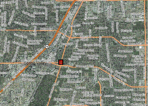
Figure 5.6-1 Incident Location at Intersection of Greenville Avenue and Spring Valley Road (Source: NCTCOG dfwmaps.com)
Assumptions:
- Major parallel route to the freeway, with impact to the corridor
- Multiple bus routes impacted
- Incident does not include any fatalities
Timeline:
| 4:00 p.m. | Incident Occurs, drivers immediately contact E911 to report the incident. Due to integration with the various E911 CAD systems, the corridor agencies are immediately notified of the potential incident (through ICM System alerting subsystems) and approximate location (through ICM System mapping). |
| 4:05 p.m. | City of Richardson police arrive on scene and begin initial determination of severity and approximate time for resolution. DART Bus Dispatch is automatically notified by the ICM system of the location, and drivers on affected bus routes are notified. |
| 4:20 p.m. | City of Richardson updates ICM System to indicate major incident with a closure of more than 1 hour. The corridor agencies are alerted through ICM alerting subsystem, and a previously approved response plan is recommended by the corridor Decision Support subsystem. Incident data is transferred to the DFW ATIS, resulting in information on the incident being sent to local media, and 3rd party ISPs, along with traveling public through various mediums. TxDOT, DART, and City of Richardson display preliminary information on DMS signs and HAR near the incident. DART displays intersection closure information on the vehicle and bus stop DMS along the affected routes. |
| 4:30 p.m. | City of Richardson implements timing plans for diversions around the intersection to parallel routes, and bus priority is implemented for pre-approved diversion routes for DART buses impacted by the intersection closure. |
| 5:00 p.m. | Initial clearance of the intersection, restoring traffic flow in all directions, City of Richardson updates ICM System. City of Richardson continues to monitor the traffic flow and change timing plans, if needed. DART and TxDOT remove DMS messages. DART is notified of opening, however, back-up still requires diversion |
| 5:20 p.m. | Normal operations, DART bus resumes routes through intersection. |
Changes to Baseline Strategies:
The approach the US-75 Steering Committee has taken is to use the Daily Operations as the baseline for the strategies associated with the ICM, and then discuss what changes and additions are needed for the specific scenario. In the following tables, the stakeholders have identified some of the additional roles and responsibilities, and data and infrastructure required to have a corridor based response. In addition, the following changes to strategies were identified:
- Information sharing and distribution
- Operational efficiency at network junctions
- A common incident reporting system and asset management (GIS) system
- Modify transit priority parameters to accommodate more timely bus service and light rail service
- Emergency response signal priority
- En-route traveler information devices used to describe current operational conditions on another network(s) within the corridor
| Stakeholder | Roles and Responsibilities |
|---|---|
| Texas DOT | Monitoring
Coordination
Information Distribution
|
| City of Richardson | Monitoring
Coordination
Information Distribution
|
| DART | Monitoring
Coordination
Information Distribution
|
Additional Data and Infrastructure Needs:
Table 5.6-2 below, identifies the data needs by agency and if the asset is currently deployed or available.
| Data and Infrastructure Needs | Texas DOT | City of Richardson | DART |
|---|---|---|---|
| Traffic detectors / roadway surveillance / vehicle probes | |
|
|
| CCTV (video surveillance) | |
|
|
| Traffic signal control / monitoring (TOD schedule) | |
|
|
| Traffic signal control / monitoring (traffic adaptive) | |
|
|
| Ramp Meters (local control) | |
|
|
| Ramp Meters (central control) | |
|
|
| DMS – roadway | |
|
|
| Internet Traveler Information | |
|
|
| Automated Incident Detection | |
|
|
| Incident Detection (call-in, other) | |
|
|
| Incident Response Plans / Guidelines / Teams | |
|
|
| Incident Reporting System (GIS, common display) | |
|
|
| Transit Vehicle Location / GPS | |
|
|
= Needed, Currently Deployed
= Needed, Not Deployed
5.6.2. Major Traffic Incident - Freeway
When deciding upon locations for scenarios multiple locations would require multiple response scenarios depending on location and time of day. In order to capture the various response strategies for a major incident, the corridor was divided into multiple sections and directions. Then based on time of day, the impact and necessary strategies could be determined. With the time available to the US-75 Steering Committee, a typical location and scenario was chosen.
Trying to use a real-world incident, the committee discussed a recent incident on US-75 at the LBJ Freeway. During the early morning hours (approximately 4 a.m.), a northbound commercial vehicle incident closed multiple exit ramps to include the interchange to LBJ. The commercial vehicle lost its load, and required clean-up and hazmat response due to over 50 gallons of diesel being spilled. The City of Plano emergency response arrived first at scene and closed three exit ramps to include the one to LBJ Freeway, a little later the City of Richardson arrived and took over responsibility. The City of Richardson opened a couple of the exit ramps. The TxDOT courtesy patrol assisted with traffic control, and began clean-up of incident. The incident went through multiple phases: initial reaction, clean-up, modifying traffic control, and resumption of normal operations. The US-75 Steering Committee discussed how ICM in the future could be used to improve the efficiency and response of the coordinated response.
Incident Description:
A commercial vehicle jackknifed on southbound US-75 north of the LBJ Freeway interchange at 6 a.m., spilling its load of boxes onto the freeway and closing the freeway in the southbound direction. The jurisdiction of the incident is the City of Richardson.
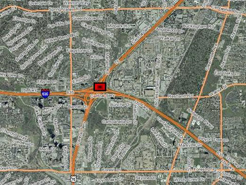
Figure 5.6-2 Incident Location on US-75 North of LBJ Freeway (Source: NCTCOG dfwmaps.com)
Assumptions:
The assumptions used for this scenario are:
- No fatalities
- Hazardous materials spill due to at least 50 gallons of diesel fuel spilled
- Long-term closure requiring mode shift, and arterial diversions
- Multiple coordinated responses needed to optimize the corridor
Timeline:
| 6:00 a.m. | Incident Occurs, drivers immediately contact E911 to report the incident Due to integration with the various E911 CAD systems, the corridor agencies are immediately notified of the potential incident (through ICM System alerting subsystems) and approximate location (through ICM System mapping). |
| 6:10 a.m. | City of Richardson police arrive on scene and begin initial determination of severity and approximate time for resolution. TxDOT courtesy patrol and DART Motorist Assistance arrive on scene to assist with traffic control. TxDOT uses video cameras to verify type of incident and number of lanes closed, and notifies ICM partners. TxDOT, DART, and City of Richardson and Plano display preliminary information on their DMS signs north of the incident. |
| 6:20 a.m. | City of Richardson updates ICM System to indicate major incident with a closure of more than 4 hours. The corridor agencies are alerted through ICM alerting subsystem, and a previously approved response plan is recommended by the corridor Decision Support system. Local wrecker service has been notified, and begins response to assist police with clearing incident. |
| 6:30 a.m. | As part of the pre-planned response contained in the corridor Decision Support system, DART begins preparation for additional light rail and bus bridging for temporary parking. City of Richardson contacts local business close to light rail station to implement pre-agreed temporary parking. City of Richardson and City of Plano implement timing plans for freeway diversions. |
| 7:00 a.m. | emporary parking lots have been started; DMS signs and static trailblazer signs provide direction to motorists to these locations. DART has begun bus bridge between the temporary lots and light rail stations. City of Richardson and City of Plano have implemented bus signal priority. |
| 9:00 a.m. | HazMat response has begun to clean-up the fuel spill. The commercial vehicle has been up-righted, and clearance of boxes in roadway has begun. |
| 9:30 a.m. | Since majority of rush hour is completed, DART begins to reduce its light rail service back to normal levels. |
| 10:30 a.m. | Clearance of boxes has completed, and some capacity is restored to the freeway, interchange ramps have all re-opened. |
| 12:00 p.m. | Roadway is back to normal operation. |
| 8:00 p.m. | Bus Bridge ends for the temporary parking lots. |
Changes to Baseline Strategies:
The approach the US-75 Steering Committee has taken is to use the Daily Operations as the baseline for the strategies associated with the ICM, and then discuss what changes and additions are needed for the specific scenario. In the following tables, the stakeholders have identified some of the additional roles and responsibilities, and data and infrastructure required to have a corridor based response. In addition, the following changes to strategies were identified:
- Information sharing and distribution
- Operational efficiency at network junctions
- A common incident reporting system and asset management (GIS) system
- Modify transit priority parameters to accommodate more timely bus service and light rail service
- Emergency response signal priority
- En-route traveler information devices used to describe current operational conditions on another network(s) within the corridor
| Stakeholder | Roles and Responsibilities |
|---|---|
| Texas DOT | Monitoring
Coordination
Information Distribution
|
| City of Richardson | Monitoring
Coordination
Information Distribution
|
| City of Plano | Monitoring
Coordination
Information Distribution
|
| DART | Monitoring
Coordination
Information Distribution
|
Additional Data and Infrastructure Needs:
Table 5.6 4 below, identifies the data needs by agency and if the asset is currently deployed or available.
| Data and Infrastructure Needs | Texas DOT | City of Dallas | City of Richardson | City of Plano | DART | NTTA | NCTCOG | City of University Park | Town of Highland Park |
|---|---|---|---|---|---|---|---|---|---|
| Highway Advisory Radio | |
|
|
|
|
|
|
|
|
| Bus Bridge | |
|
|
|
|
|
|
|
|
| Light Rail Signal Priority | |
|
|
|
|
|
|
|
|
| Bus Signal Priority | |
|
|
|
|
|
|
|
|
| Emergency Vehicle Signal Pre-emption | |
|
|
|
|
|
|
|
|
| Temporary Parking Lots – local business coordination | |
|
|
|
|
|
|
|
|
| Incident Location | |
|
|
|
|
|
|
|
|
| Incident Status | |
|
|
|
|
|
|
|
|
| Incident Details | |
|
|
|
|
|
|
|
|
= Needed, Currently Deployed
= Needed, Not Deployed Data and Infrastructure Needs
5.6.3. Major Transit Incident
The US-75 Steering Committee discussed various potential scenarios for disruption of the transit network, and tried to decide upon location, time-of-day, and incident parameters. In order to capture the various response strategies for a major transit incident, multiple transit modes and impacts could be shown. Based on time-of-day, the impact and necessary strategies could be determined. Some of the scenarios discussed included outage due to strikes, train breakdown, rail shutdown, major crime event, surface street intersection incident involving light rail, morning in-bound transit scenario, and evening out-bound transit scenario – each of these would require different strategies and responses. A LRT train hitting a pedestrian during evening peak volume period was decided upon due to: the need to shut both directions of travel down; the relatively high frequency of actual DART LRT pedestrian accidents; and due to the evening peak volume that LRT customers who are already in Dallas not having the option of working from home – as would be the case for a morning peak event.
Incident Description:
A pedestrian is hit by a DART Red Line LRT light-rail train at 4:30 p.m. After reporting the incident to DART dispatch personnel, the train operator is directed to hold the train at the Lovers Lanes station until emergency response arrives. The pedestrian accident leaves the LRT train in a position that is not blocking surface street arterial lanes.
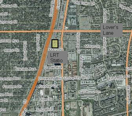
Figure 5.6-3 Incident Location in DART Red Line (Source: NCTCOG dfwmaps.com)
Assumptions:
- Minor impact to arterial network travel conditions, outside of 2 block vicinity of incident
- Little/no impact to freeway travel conditions
Timeline:
| 4:30 p.m. | Train operator radios pedestrian accident to DART dispatch, which then relays incident information and location to City of Dallas 911 dispatch. |
| 4:35 p.m. | Train ordered to remain in current location and exact location details are input into ICM System. DART and City of Dallas operators access TxDOT and City CCTV that are able to see incident scene and surrounding arterial network conditions. |
| 4:37 p.m. | Responders arrive on scene and begin relaying incident details, which are input into ICM system. DART enters incident information into DFW ATIS, and puts incident information out through vehicle and station DMS and PAs, as well as customer service and web trip planning services. |
| 4:45 p.m. | Incident responders relay that investigative operations will likely hold the train at current location and shutting down both directions of Red Line LRT for 2.5 hours. DART dispatch begins coordinating the transfer of Blue-Line LRT customers at the incident scene onto spare DART buses. Additionally, DART references ICM System Decision Support Tool for additional strategies based on modeling. Strategy of adding bus vehicles to adjacent lines, and beginning bus bridges to Red Line LRT are initiated. |
| 5:00 p.m. | City of Dallas sees DART bus lines have been increased and begins coordination for increased transit vehicle priority along City arterials. |
| 7:30 p.m. | DART verifies real-time ridership data and confirms ICM System Strategy to begin normal reduction in bus service due to time-of-day lower volumes. However, DART keeps the service higher than normal to accommodate for additional travelers using bus due to Red Line closure. |
| 8:15 p.m. | Incident investigative operations are finalized and Red Line LRT is reopened for travel. DART updates incident status in ICM System, as well as DFW ATIS. |
Changes to Baseline Strategies:
The approach the US-75 Steering Committee has taken is to use the Daily Operations as the baseline for the strategies associated with the ICM, and then discuss what changes and additions are needed for the specific scenario. In the following tables, the stakeholders have identified some of the additional roles and responsibilities, and data and infrastructure required to have a corridor based response. In addition, the following changes to strategies were identified:
- Information sharing and distribution
- Operational efficiency at network junctions
- A common incident reporting system and asset management (GIS) system
- Modify transit priority parameters to accommodate more timely bus service and light rail service
- Emergency response signal priority
- En-route traveler information devices used to describe current operational conditions on another network(s) within the corridor
- Modify transit priority parameters to accommodate more timely bus service
- Modify HOV restrictions (increase minimum number from 2 to 4)
- Increase roadway capacity by using shoulders for traffic (peak periods)
- Add transit capacity (express bus service during peak periods) by adjusting headways and number of buses
- Add temporary new transit service (bus bridge)
- Peak spreading by outreach to media/commuters on ridesharing and telecommuting during closure of the section of rail
| Stakeholder | Roles and Responsibilities |
|---|---|
| Texas DOT | Monitoring
Coordination
Information Distribution
|
| City of Dallas | Monitoring
Coordination
Information Distribution
|
| DART | Monitoring
Coordination
Information Distribution
|
Additional Data and Infrastructure Needs:
Table 5.6 6 below, identifies the data needs by agency and if the asset is currently deployed or available.
| Infrastructure Needs | Texas DOT | City of Dallas | DART |
|---|---|---|---|
| Transit schedules | |
|
|
| Transit vehicle location | |
|
|
| Available transit vehicles / location | |
|
|
| Video images / snapshots | |
|
|
| Incident location | |
|
|
| Incident status / details | |
|
|
| Emergency vehicle location | |
|
|
| Contact lists | |
|
|
| Incident Detection (call-in, other) | |
|
|
| Incident Response Plans / Guidelines / Teams | |
|
|
| Incident Reporting System (GIS, common display) | |
|
|
| Transit Vehicle Location / GPS | |
|
|
| Transit Public Address System | |
|
|
| Public Safety CAD | |
|
|
| Emergency vehicle priority / preemption (Intersection / Vehicles) | |
|
|
= Needed for Scenario, Currently Deployed
= Needed for Scenario, Not Deployed
5.7. WEATHER EVENT SCENARIO
The US-75 Steering Committee discussed various potential scenarios for weather events, how likely they could occur, and tried to decide upon specific events that currently occur. In order to capture the various response strategies for different types of weather, the committee discussed how each event impacts their current systems, and how often these events occur. It was also decided that depending on the weather event, location of impacts, and time of day – different responses would be needed. In order to discuss the various potential responses, the following events were discussed:
5.7.1. Rain
Rain does occur frequently, and have a general impact to the flow of traffic; this includes transit, freeway, and arterials, which usually decreases the average speed and decreases throughput of the corridor. Rain also does provide some impact to traffic signal systems in some areas, and reduces the speed of the light rail system. Several locations within the corridor lose power to the traffic signals during heavy rain events, which can cause various response strategies to be implemented (re-routing, police manually doing traffic control, etc.)
The strategies and responses to this scenario would be a subset of minor and major arterial scenarios, minor incidents on transit, and minor incidents on freeways.
5.7.2. Ice
Ice storms do occur a couple times per year on average in Dallas, and have tremendous regional impact. Since these events do not occur often, the agencies within the region do not have the resources (plows, salt trucks, etc.) that some northern locations that routinely have snow and ice would have. This causes various issues and incidents. Many of the businesses in the region will shutdown during ice storms, and in general discourage travel during these events.
Similar to rain, overall speeds decrease significantly and throughput increases. Also, incidents increase during this time on arterials and the freeway. One interesting side effect is also the impact on transit. The light rail system will sometimes be impacted due to ice that coats the power lines overhead of the vehicle and the contact between the vehicle and the power line is disrupted, causing shutdown of the vehicle. Overall, when discussing responses to this scenario, the committee focused more on the information needed and distributed to the public to try and reduce travelers during these events.
5.7.3. Ozone Alert / Action Day
Dallas is an air quality non-attainment area, and due to the heat during the summer months frequently has ozone alert and ozone action days. Part of the current response is to market heavily through the media, and ATIS systems. The committee also discussed the potential for using the ICM for additional mode shift to include increasing transit usage, and car pooling. Similar to a major freeway incident, temporary parking lots would be needed, to include bus bridges, and signal priority.
| Stakeholder | Roles and Responsibilities |
|---|---|
| Texas DOT | Monitoring
Coordination
Information Distribution
|
| City of Dallas | Monitoring
Coordination
Information Distribution
|
| City of Richardson | Monitoring
Coordination
Information Distribution
|
| City of Plano | Monitoring
Coordination Information Distribution
|
| DART | Monitoring
Coordination
Information Distribution
|
| North Texas Tollway Authority | Monitoring
Coordination
Information Distribution
|
| Town of Highland Park | Monitoring
Coordination
Information Distribution
|
| City of University Park | Monitoring
Coordination
Information Distribution
|
| North Central Council of Governments | Monitoring
Coordination
Information Distribution
|
The data and infrastructure needs listed in Table 5.7-2 below are only related to the specific weather information needs, for incidents occurring during these events on arterials, freeway, and transit the needs identified for those scenarios would be required.
| Data and Infrastructure Needs | Texas DOT | City of Dallas | City of Richardson | City of Plano | DART | NTTA | NCTCOG | City of University Park | Town of Highland Park |
|---|---|---|---|---|---|---|---|---|---|
| Weather Information Data | |
|
|
|
|
|
|
|
|
| Air Quality Monitors | |
|
|
|
|
|
|
|
|
| RWIS – tied into regional ATIS | |
|
|
|
|
|
|
|
|
| Weather Information – weather service | |
|
|
|
|
|
|
|
|
| Marketing – public information (weather events) | |
|
|
|
|
|
|
|
|
| Marketing – business outreach (weather events) | |
|
|
|
|
|
|
|
|
| Light Rail – weather sensors/ monitoring | |
|
|
|
|
|
|
|
|
| Flood Detectors (critical field infrastructure locations in flood plain) | |
|
|
|
|
|
|
|
|
= Needed, Currently Deployed
= Needed, Not Deployed