5 Uses of Real-Time Data
Real-time traveler information has a variety of internal and external applications. This information can provide users with situational awareness of the transportation network and can be provided through a variety of mediums, depending on who is receiving the information. Providing information to system users allows customers to make better decisions regarding the scheduling and routing of their trips to increase safety and reduce stress. In addition to providing users with information, the data stemming from real-time information applications can be utilized internally as well and allow agencies to improve their systems operations and performance.
5.1 Traveler Information
While travelers still require static information, they also appreciate real-time information when it is available to them for both familiar and unfamiliar trips. Both the public and private sectors strive toward the development of a ubiquitous real-time exchange of information with customers and a seamless integration of services. Effective real-time traffic information enables drivers to adjust their trip decisions to avoid congestion or at least to reduce the uncertainty of total trip time and estimate time of arrival. While traveler information may not necessarily reduce travel time, it can still enable users to account for day-to-day variability, hence increasing arrival time reliability. Users generally appreciate having traveler information, regardless of whether they can make any change to their trip behavior, due to reduced stress from knowing what future conditions will be. Across the four market segments, the increased situational awareness provided by real-time traveler information improves efficiency and reduces uncertainty. For all types of information, increased accuracy increases frequency and dependency of use.
The traveler information industry is also interested in using real-time traveler information applications to influence the decisions that travelers make including mode choice. Both the public and private sectors are interested in working with end-users to learn how real-time applications are used. The entire suite of real-time information can affect customer’s decisions on what trips to take and what mode of travel to use. For example, when real-time parking information is available for a facility at or near a transit station, the knowledge of parking availability has been shown to be a powerful incentive to encourage drivers to switch to transit. Further encouragement can be added when the parking availability information is coupled with real-time transit information or static parking information such as attribute level data regarding parking spaces including its proximity to their final destination, pricing, and security.
Real-time transit traveler information is set apart in its ability to not only provide current overall system operational information, but also individual vehicle location information. This can include information related to service disruptions, vehicle arrival times, and even vehicle capacities. This information can serve as beneficial value-added service for both transit-dependent and transit discretionary riders. Approximately 60 percent of transit riders are transit dependent, meaning that while they will likely find real-time transit traveler information systems convenient, additional services will not likely increase their ridership. Conversely, 40 percent of transit customers are discretionary riders, meaning that improved services could increase the frequency of their ridership. For real-time traveler information services to increase transit ridership, discretionary travelers must trust the information being provided to them and find that it improves their transit experience. Transit ridership can further be increased by informing non-transit riders that high-quality and convenient transit services exist.
Like passenger vehicles, commercial vehicles often require real-time traveler information that provides situational awareness of local traffic and weather conditions. Such information can be used to optimize supply chains and freight movements, impacting the productivity and safety of commercial vehicles. While all types of vehicles are concerns with traffic, weather, routing, and parking, commercial vehicles often require information specific to their operational parameters. For example, instead of the local weather updates that most passenger vehicles would be interested in, trucks on long-haul routes might be interested in predicted weather conditions several hundred miles down the road. This information is of particular importance to commercial drivers because unlike automobile drivers, commercial drivers have a restricted number of hours of service that limit their driving time regardless of delays. Since drivers are often paid by the mile, they strive to efficiently use their hours of service and may decide to shut down in heavily congested traffic or severe weather. The decision to shut down is often difficult for many truckers, so any real-time or forecasted information that may improve their decision-making process is appreciated.
Some types of real-time information, particularly parking and freight information, require a certain level of predictive information. To improve parking decision making, customers need to receive parking information either before they leave for their destination or en route. Customers inquiring about pre-trip information are trying to make a decision on parking location well ahead of their arrival at the parking facility, meaning they seek some type of predictive information related to the location of available parking spaces upon arrival. Real-time, historical, and discrete event information can be combined via unique algorithms to provide a prediction of parking availability in the near future, particularly within the next 5 to 15 minutes. While some operators have developed the ability to forecast information, such algorithms are still in the development stage. Forecasting information is often impossible or inaccurate given limited data or inadequate algorithms. Additionally, developing an algorithm to forecast information is often an expensive and arduous undertaking, requiring each parking facility to examine its own historical trends and other factors that might impact availability. Furthermore, some private operators may not want to tell every patron that their facility is full, such as shopping malls or private truck parking facilities.
Long-haul commercial vehicles may also require a certain degree of predictive information. Due to the nature of their trips, having information for local conditions several hours down the road is optimal for route and schedule planning. For example, if long-haul truckers know that congestion or weather conditions are likely to be unfavorable on their current routes, they may decide to reroute or take a break earlier than initially anticipated.
5.1.1 Demographic Considerations for Information Dissemination
While all travelers appreciate real-time information, public sector information providers must realize that the various customer demographics necessitate different information requirements and preferences for accessing information. Many older users still prefer to access information through 511 services, while Web-based and wireless applications are more popular with younger users. When deploying a real-time transit information system, Portland TriMet initially planned to deploy numerous DMS at all of its transit stations, but decided to only focus on light rail locations because the majority of riders had cell phones and would just dial in requests for information. Generally, riders tend to use a small number of stops; therefore, accessing and memorizing bus-stop numbers for 511 systems is typical. Despite the convenience that real-time information systems are able to provide, many transit riders are not even aware of the entire suite of real-time information that transit agencies make available to them. Others riders are not able to acquire information because they do not possess the technology necessary to access it such as a Web-enabled computer or a cell phone. Furthermore, agencies must consider information dissemination requirements for passengers with disabilities, including visually impaired riders unable to see DMS.
5.1.2 Public Sector/Agency Operated Systems
5.1.2.1 Dissemination Mediums
A variety of mediums exist to provide real-time traveler information. While each is at various stages of development, providing information through as many mediums as possible promotes information dissemination to the widest group of customers. Table 5.1 shows the potential methods that public agencies can use to provide real-time traveler information.
5.1.2.2 Considerations for Dissemination
System designs must be sensitive to include accessibility options to meet Americans with Disabilities Act (ADA) regulations and lower-income rider needs that may not have access to all methods of information dissemination. Agencies are working with these communities to best meet their needs in providing appropriate alternative solutions. To prevent adversely affecting these communities and facing potential lawsuits, agencies must involve these communities early in the planning process. They must think carefully about how information is disseminated to the traveler population, ensuring that the needs and preferences of user groups are met, balancing various types of information. DMS, while extremely useful for many situations, are not a panacea for all locations due to cost, potential for vandalism, and lack of need. Website access is often not readily available to customers and to many travelers at both ends of their journey. Smartphones increase connectivity but are not widely implemented yet. Furthermore, not all applications are compatible with each other given the many different Smartphone, Smartphone operating systems, and platform-dependent applications. Smartphones are also often only a viable option for technologically adept customers desiring information immediately. Another consideration for implementation is the involvement of the ADA community, as required by law. Accommodations must be made for riders with visual or auditory impairments. While practical and financial reasons prevent providing accommodation for every disability at every transit station, transit agencies must involve the ADA community early on in the implementation of a real-time system to ensure the development of a holistically compliant system that addresses the community’s needs through technology and pragmatism. Agencies must be conscientious regarding what real-time information disadvantaged communities require.
Information must be presented to users in an intuitive way so they can quickly assess it and make a decision. For example, highway travel times can display the time travel to a specific location, but including the distance along with the travel time can improve the percentage of travelers reading the message and their ability to make an informed decision. For travelers receiving parking information, telling a driver that there are 30 spaces available means little if the user is unfamiliar with the context of the facility. Instead, more broad categories should be used to explain parking conditions. For example, a green indicator that means plenty of parking is available, a yellow indicator meaning that parking is limited, and a red indicator meaning that parking is currently unavailable can be more easily processed.
Although a robust system has yet to be deployed, truck parking deployments use many of the same dissemination methods as passenger vehicles, including DMS and the Internet. To receive forecasts, truckers can tune to HAR. Ideally, parking facilities will be networked so drivers can easily be diverted to the next nearest parking space. Even though numerous drivers use them regularly, NTSB recommends that systems do not encourage drivers to use cell phones while in motion.
5.1.2.3 Usage Statistics for Public Sector Systems
One state DOT indicated that it sees much higher market penetration from its traditional traveler information systems (namely its Web site, which averages 15,000,000 monthly hits versus 5,000 followers to its Twitter site). Despite the higher percentage of use, it has received positive publicity from local media for reaching out to new audiences through the use of the innovative social networking tools.
Transit agencies track usage statistics for their 511 systems and Website services to evaluate the impact and support the required operations and maintenance expense. Table 5.2 documents observed usage metrics from several prominent transit agencies, and Figure 5.1 shows the growth in 511 deployments and usage from June 2001 through May 2009.
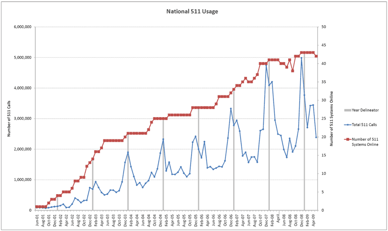
Figure 5.1: National 511 Deployment and Usage Trends Source: 511 Deployment Coalition Statistics Update
5.1.3 Private Sector Traveler Information Services
5.1.3.1 How Commercial Drivers Use Real-Time Information
While commercial vehicles desire similar information to passenger vehicles, there are some significant differences in the information they require and how they use it. Many truckers would rather see events of greater magnitude that would interrupt a long-haul trip, as opposed to the commuter information used by many passenger vehicles. They also require information across jurisdictional boundaries, including information several hours down the road such as future closure information. Commercial vehicles may also require additional information such as shipper/consignee hours of operation or information regarding oversize/overweight restrictions and permitting.
The next generation of telematics is providing more information to drivers, including turn-by-turn directions and weather information. Drivers appreciate the information they receive, particularly information regarding the “last mile” to their destination. Generally, more-granular information provided is always better. Commercial drivers are only allowed a certain number of hours of service. Therefore, unlike a passenger vehicle driver that is more likely to use real-time information to reach a destination as soon as possible, a commercial vehicle driver may decide to alter his/her driving schedule to maximize driving efficiency. Depending on the value of their cargo and when it is due at its destination, real-time information may be of particular value to commercial operators.
5.2 System Management and Operations
In addition to providing real-time traveler information to customers, transportation agencies can leverage the information stemming from real-time applications to improve their own internal operations, including management of their own fleets and infrastructure. For example, information can be used to monitor conditions, increase the accuracy of transit schedules, or improve the utilization at a parking facility.
5.2.1 Traffic Management and Operations
Real time data used for traffic management plays an important role in roadway operations. Active traffic management is only beneficial if the data provided to an operator or a system is accurate and timely. Traffic management centers utilize sensors, cameras and incident responders to provide the operators with information to manage traffic. Freeway management is more prevalent than arterial management due to the greater availability of information for major highways. For arterials, real-time intersection and system detection data is crucial for signal operations.
5.2.2 Fleet Management and Operations
In addition to real-time traveler information, many agencies use GPS AVL for improvements in vehicle fleet management and operations. Although AVL is costly to install and maintain, it is the only effective method for tracking vehicle location, which is necessary to provide the level of service that customers have come to expect. Even if it is not disseminated to users, tracking schedule adherence can indicate whether vehicles are behind or ahead of schedule to allow for improved spacing that avoids platoons of clustered vehicles. Transit agencies often focus their attention on their highest-capacity routes, where bus headways are as frequent as every 3 to 5 minutes during peak periods.
Carriers, particularly larger carriers, are using real-time applications to improve their operations, including improved routing, scheduling, and driver efficiency. Since some telematics systems provide multi-lateral communication (driver, dispatcher, manufacturer and vendor), instruments on the truck can also serve to diagnose the vehicle’s en route operating efficiency, including fuel efficiency, mechanical specifications, and software updates. However, while possible, many of these changes to operating parameters have yet to be enacted, with few carriers using these systems as standard equipment.
Geofencing – Telematics provide dispatchers with an opportunity to better manage the specific location of their vehicles, for both security and operational efficiency purposes. Telematics allow dispatchers to “geofence” their vehicles, whereby a vehicle’s route and operating characteristics (speed, driving pattern, etc.) can be prescribed. If the vehicle deviates from the prescribed operating characteristics, the vehicle is flagged to a dispatcher who can liaison with the driver to assess a problem. Geofencing is becoming increasingly common, particularly for high-value and HazMat shipments. Geofencing and prescribed routing will likely become more common as systems are deployed to more vehicles and sensors are able to track vehicles with greater precision. While some drivers are hesitant to be tracked in such detail, most drivers appreciate being tracked because it removes the pressure of being creative to get to their destination on time. Geofencing provides a unique opportunity for carriers to increase the security and efficiency of freight shipments.
5.2.3 Parking Management
Once data is obtained from parking sensors, it is possible to build information models on arrivals, departures, occupancy, duration, and availability, as well as information reflecting demand. Networked meters can deliver information regarding current operational and payment conditions and historical transactions, which can be used to produce a complete real-time and historical view of compliance, violations, actual versus potential revenue, and options for improving pricing and policy.
Pricing Signal for Reservation-based Systems – In general, moving from a “free” to a “pricing” model often greatly impacts customers’ decision to use a parking facility, including systems with reservations, signaling what customers are and are not willing to pay for and how much they are willing to pay. However, at the BART Rockridge implementation, even when a charge became associated with the program, 800 people (approximately 66 percent) stayed with the program, indicating that customers are willing to pay for the valued-added service they receive from parking information and the ability to make a reservation. Instead of “paying” with their time by showing up early to secure a space and risking whether one was available, these customers were willing to pay a fee to secure a guaranteed parking space. In addition to transit stations, reservation systems can also be associated with entertainment events, especially those where tickets are frequently purchased online in advance (concert, professional sports game, etc.), and a parking reservation can be bundled as part of the transaction.
5.3 Performance Measurement
Extensive data must be collected to properly measure the effects of new parking facilities or policies. Collecting data related to factors such as economic conditions, enforcement practices, and gas prices allows planners to examine impacts over time and explain variations in behavior. This will provide researchers and policy planners with information regarding how policies affect congestion and turnover and how policies can be used to improve overall programs.
In municipal street systems like SFPark, real-time information will improve efficiency for enforcement personnel through immediate notifications of expired meters and eliminating the need to check every meter. Furthermore, customers will have the option to top up their parking meter from their cell phone; so enforcement can be characterized as a public benefit instead of a punitive damage for forgetting to refill a parking meter.
Real-time freight information applications can also be used to expand knowledge of freight flows around the country, within a region, or across a particular border. Aggregating freight data from individual vehicle locators, weigh-in-motion detectors, or wireless safety inspections helps both the public and private sectors improve their handle of when and who is utilizing heavy freight corridors and how commodities are flowing. Increased data sharing will encourage data aggregation and improve the understanding of freight movements. The federal government has already taken an interest in tracking commercial vehicle origin-destination via the FHWA’s Freight Performance Measures Initiative, but believes that conducting additional probing would serve to increase understanding, including discovering additional locations where real-time freight information is needed.
Real-time information can also be leveraged to track vehicle and driver performance. Telematics can track fuel consumption and optimization. Dynamic routing improves efficiency, allowing for decreased fuel consumption. It also allows operators to more accurately track revenue per mile, number of trips required, and other long-range planning activities. Also, some systems have features that allow carriers to track the safety performance of their drivers, including speed and transmission information.
5.4 Usage Trends
5.4.1 Social Networking
An important emerging trend is the use of social networking tools (such as Twitter, Facebook, or blogs) by DOTs and regional transportation organizations as a traveler information dissemination tool. Several DOTs have recently incorporated some of these tools into their information dissemination strategies. A few years ago, a popular strategy emerged for DOTs to use podcasts to provide weekly updates for major construction activities or for large-scale event pre-advisories. Even though podcasts are applying newer online strategies to reach expanded audiences, they were not intended to be updated in real time. Twitter and Nixle are two social networking tools that are gaining prominence. Several DOTs, including WSDOT, Kansas DOT, and Virginia DOT, are using Twitter to provide traffic and travel condition updates. Texas DOT uses Twitter for statewide emergency notifications, but the Houston TranStar program has established a Twitter site where users can single out specific corridors to follow and receive notifications. This allows users to pre-select specific corridor updates and minimize receiving a myriad of regional information and details that might not be relevant.
One of the challenges with Twitter is that it is open to allow users to also post content, so DOTs have very little control over user-generated content that might appear on their Twitter pages. Maintaining accuracy on these fast-moving and user-populated sites could impact overall quality.
Social networking has the potential to become another substantial medium of communication between transit agencies and customers and among customers. Online applications like Facebook, RSS feeds, and Twitter can share information related to congestion, incidents, and construction and are especially popular with younger users. Transit agencies must be aware of the potential legal issues that surround their use, including restrictions regarding a municipal organization being part of a public forum.
5.4.2 Safety Concerns
Safety groups are concerned that providing in-vehicle information to commercial vehicles can be potentially dangerous if it causes a distraction to the drivers. Some jurisdictions even ban cell phone usage while operating a vehicle. Furthermore, recent NTSB recommendations have indicated that new commercial vehicle information applications should refrain from using cell phones for information dissemination. In-vehicle communication systems provide a safer option for truckers to obtain information such as systems that use 16-character message displays on the truck that provide just enough information for the driver to make a quick decision about whether to pull over and view the entire message or if it is a message that can wait for the next time they are already pulled over. The next generation of telematics is utilizing hands-free voice and mapping instead of requiring any text to be read. Truckers are readily accepting the use of these devices when available to them, and vendors are willing to work within the confines of the new recommendations to provide safer, better systems.
5.5 Real-Time Data Usage Gaps
5.5.1 Traffic Usage Gaps
There is a gap regarding the sharing of traffic data between different departments. For example, the Operations department often does not think to share data with the Planning department, and vice versa. The same may be the case for traveler information programs. Different departments often deploy their own data collection systems and do not adequately leverage each others’ efforts. While each department has its own data needs, there is still a gap with respect to lack of sharing data between departments and programs.
5.5.2 Transit Usage Gaps
5.5.2.1 Understanding of Real-Time Information Usage Gap
Transit agencies lack an understanding of how transit riders use real-time information, including detailed usage statistics to understand how travelers access information and how the information affects their travel choices. Furthermore, transit agencies also need to improve their understanding of the needs of various types of transit riders, including the needs of discretionary versus captive riders, younger versus older riders, and other demographic groups. Obtaining a more complete understanding of individual users could broaden the usage of transit information and promote market sustainability.
5.5.2.2 Mode Switching Gap
A critical function that still must be developed is how to better leverage accurate real-time transit information to encourage users to switch to transit from their personal vehicles. One way to leverage this would be to include information about available transit services when drivers search for auto travel information. In most urban areas in the United States, a very small fraction of travelers have used transit services in the recent past and thus are not well informed about the services available and their quality. It is critical to increase awareness of good transit alternatives, and where they exist, to travelers planning to make trips by automobile. In select locales, Google has begun to suggest public transit routing when someone enters a driving destination in Google Maps and a transit alternative is available and timely. The government can play a role in encouraging this, or even mandating it where government funds are being used to help provide the information service. The US DOT’s Integrated Corridor Management (ICM) Initiative seeks to create additional intermodal linkages, including providing real-time information to encourage mode switching such as comparative travel times. Several agencies are working toward deploying systems that provide transit and parking information to highway drivers including I-35 in Minnesota and I-80 in California. The US DOT aims to continue deployment through ICM over the next several years.
5.5.3 Parking Usage Gaps
5.5.3.1 Effects of Smart Parking Policies
Smart parking is still a budding industry with little understanding of how new technologies can be leveraged to change driver behavior. Because of this, many municipalities still do not understand how to appropriately use real-time parking information to improve parking policies, increase transit ridership, or decrease overall vehicle-miles traveled. Additional studies must be conducted to develop a better understanding of how drivers respond to smart parking, including time limits, new enforcement practices, and pricing signals.
5.5.4 Freight Usage Gaps
5.5.4.1 Training Gap
Some non-tech-savvy truckers lack the technical expertise to use the newest real-time freight information systems, including both public and private systems. This is particularly an issue with independent owner-operators who do not have the support of a large company to encourage them to learn to use more advanced systems. Even if states, intermodal facilities, or border crossings are able to provide accurate and useful information, it is only useful if a substantial portion of the driver population uses it regularly. Freight information providers need to work with the trucking community to educate drivers in accessing the information provided.
5.5.4.2 Data Usage Analysis Gap
Few studies or surveys have been conducted to determine how truckers prefer to receive and use real-time freight information, including how many truckers regularly use public sector information, how they prefer to receive it, and how it impacts their choices. Many experts are able to speculate on these issues, although little hard data is available to support their intuitions. Some origin-destination studies may provide some insight, although even these are limited.
5.6 Closing the Gap and Roles for the US DOT
Although real-time traveler information is already benefiting many customers, additional outreach conducted by the US DOT and its partners will further encourage usage and information exchange. This includes promoting traveler information to a variety of potential customers, including daily commuters, out-of-town travelers, and fleets. This could also include marketing campaigns and incentive programs. In addition another gap needed to be bridged is the sharing of traffic data between different departments. An example of this would be to facilitate data sharing between operations, planning and traveler information groups. Since all groups may deploy their own data collection systems there is a need encourage various groups to leverage what others are doing already.
The US DOT can also play a critical role in encouraging state agencies and the private sector to standardize approaches to how information is presented to the public as the United States moves closer to a seamless national network of traveler information. However, moving toward this network should take into consideration recent laws against cell phone usage and recommendations from NTSB, which encourage the government and industry to avoid traveler information systems that require truckers to use cell phones, as they increase the risk of crashes. New methods for allowing truckers and other travelers to communicate in ways that limit distraction will improve overall safety.
Finally, the US DOT can lead an effort to better understand how travelers use real-time information, especially in developing market segments like transit, parking, and freight, to broaden the usage of real-time information and promote market sustainability. This includes an understanding of how various user groups (e.g., commuters, tourists, lower income, disabled) are taking advantage of real-time services.