
![]()
Kansas City Scout
WEATHER INTEGRATION PLAN
FINAL
March 9, 2010
Prepared by
Nancy Powell
Project Team Leader
Acknowledgments
KC Scout wishes to thank the valued members of the Weather Integration Team and their organizations for allowing them the time and resources to participate in this project. The names of the team members, their organizations, position titles and email addresses are as follows:
Name: |
Company: |
Position: |
Email: |
|---|---|---|---|
Julie Adolphson |
NWS/WFO Pleasant Hill, MO |
Meteorologist in Charge |
julie.adolphson@noaa.gov |
Andy Bailey |
NWS/WFO Pleasant Hill, MO |
Warning Coordination Meteorologist |
andy.bailey@noaa.gov |
Jason Sims |
KC Scout |
TMC Manager |
ervin.sims@modot.mo.gov |
Jeremy Ball |
KC Scout |
Consulting Traffic Operations Engineer |
jeremy.ball@modot.mo.gov |
Nancy Powell |
KC Scout |
TMC Supervisor |
nancy.powell@modot.mo.gov |
Don Spencer |
KC Scout |
TMC Supervisor |
donald.spencer@modot.mo.gov |
Scott Browning |
KC Scout |
TMC Operator |
scott.browning@modot.mo.gov |
Jim Musil |
KC Scout |
Sr. Info Systems Technologist |
james.musil@modot.mo.gov |
Gary Covey |
RKV Consultants |
Contract Project Mgr |
gary.covey@modot.mo.gov |
Jim Burgess |
MoDOT |
MoDOT District Maintenance Engineer |
james.burgess@modot.mo.gov |
Karen Gilbertson |
FHWA, Kansas Div. |
ITS/Traffic Operations Engineer |
karen.gilbertson@dot.gov |
Barb Blue |
KDOT |
ATIS/511 Program Mgr. |
bblue@kdot.org |
Leslie Fowler |
KDOT |
ITS Program Mgr. |
leslie@ksdot.org |
Cathy Jones |
KDOT/KC Scout |
KDOT ITS Liaison |
cathyj@ksdot.org |
Special Acknowledgments
This project would not have succeeded without the guidance and project oversight provided by Christopher Cluett, Ph.D. and Fred Kitchener, consultants to Federal Highway Administration. We also acknowledge the leadership of Roemer Alfelor, who is with the FHWA Road Weather Management Program (RWMP) and is providing oversight for this national weather integration planning effort. We thank you and hope this effort contributes to the success of other TMCs.
Glossary of Acronyms
| AADT | Annual Average Daily Traffic |
| ATIS | Advanced Traveler Information System |
| ATMS | Advanced Transportation Management System |
| AVL | Automatic Vehicle Location |
| CAP | Common Alerting Protocol |
| CCTV | Closed Circuit Television |
| CMS | Changeable Message Signs |
| D4 | District 4 (one of 10 MoDOT Districts) |
| DMS | Dynamic Message Signs |
| DOT | Department of Transportation |
| ER | Emergency Response (MoDOT) |
| ESS | Environmental Sensor Stations |
| FHWA | Federal Highway Administration |
| HAR | Highway Advisory Radio |
| HQ | Headquarters |
| ITS | Intelligent Transportation Systems |
| KDOT | Kansas Department of Transportation |
| KHP | Kansas Highway Patrol |
| KTA | Kansas Turnpike Authority |
| MA | Motorist Assist (MoDOT) |
| MARC | Mid America Regional Council |
| MAV | Motorist Assist Vehicle |
| MCS | Motor Carrier Services |
| MDC | Mobile Data Computer |
| MODOT | Missouri Department of Transportation |
| MOU | Memorandum of Understanding |
| MPO | Metropolitan Planning Organization |
| MS | Microsoft |
| NCDC | National Climatic Data Center |
| NGD | Next Generation Desktop |
| NDFD | National Digital Forecast Database |
| NDOR | Nebraska Department of Roads |
| NOAA | National Oceanographic Atmospheric Administration |
| NWS | National Weather Service |
| OGL | Operation Green Light |
| RFP | Request for Proposals |
| RTMC | Regional Transportation Management Center |
| RWIS | Road Weather Information System |
| RWMP | Road Weather Management Program |
| TMC | Traffic Management Center |
| TMS | Traffic Management System |
| USDOT | US Department of Transportation |
| VDS | Vehicle Detection Stations |
| WFO | Weather Forecasting Office |
List of Figures
Revision History
Revision |
Issue Date |
Status |
Author |
Comments |
001 |
November 3, 2009 |
Draft |
NP/KC Scout |
Under Review |
002 |
February 26, 2010 |
Draft |
NP/KC Scout |
Review Completed |
003 |
March 9, 2010 |
Final |
NP/KC Scout |
Ready for Distribution |
Table of Contents
- 1.0 Introduction
- 1.1 Project Description
- 1.2 Electronic Self-Evaluation and Planning Guide
- 1.3 FHWA Project Status 2008 – 2009
- 1.4 KC Scout TMC Profile
- 1.5 Kansas City Scout’s Interest in Weather Integration
- 1.6 Selection of KC Scout as Participant in FHWA Weather Integration Project
- 1.7 Timeline of Project Team Activity
- 2.0 KC SCOUT TMC OVERVIEW
- 2.1 Background Information
- 2.2 A Look Inside The KC Scout TMC
- 2.3 Geographical Representation of Scout Coverage Area
- 2.4 Jurisdictional Coverage
- 2.5 Average Annual Daily Traffic (AADT)
- 2.6 Current Levels of KC Scout Staffing
- 2.7 Historical Weather Events for the Coverage Area
- 2.8 Weather Information Integration Sources
- 2.9 Existing Public Weather and Traffic Information Systems
- 2.10 Area Traveler Information Websites.
- 2.11 Impacts of Weather Events on KC Scout’s Operations
- 2.12 Internal TMC Weather and Transportation Management Systems
- 2.13 MoDOT Motorist Assist
- 2.14 MoDOT Maintenance Crews
- 2.15 KHP Motorist Assist Vehicles (MAV)
- 2.16 RWIS (Road Weather Information System) Deployment
- 2.17 Other Scout Integration Efforts – Ramp Metering Began November 20, 2009
- 2.18 Other MoDOT Weather Integration Efforts – Solar Bridge Warming System Initiative
- 2.19 Other KDOT Weather Integration Efforts – Wind-Induced Truck Crash Study
- 3.0 CONCEPTS OF OPERATIONS
- 4.0 RELATIONSHIP TO OTHER PLAN DOCUMENTS
- 5.0 WEATHER INTEGRATION SELF-EVALUATION PROCESS
- 6.0 INTEGRATION NEEDS
- 7.0 INTEGRATION SOLUTIONS
- 7.1 Use of Internal Weather Information Resources
- 7.2 Use of External Weather Information Resources
- 7.3 Availability of Weather Information
- 7.4 Frequency of Weather Forecasts
- 7.5 Frequency of Weather/Road Weather Observations
- 7.6 Weather Information Coordination
- 7.7 Extent of Coverage
- 7.8 Interaction with Meteorologists
- 7.9 Alert Notification
- 7.10 Decision Support
- 7.11 Weather/Road Weather Data Acquisition
- 8.0 IMPLEMENTATION OF INTEGRATION PLAN
- 9.0 OPERATIONS AND MAINTENANCE REQUIREMENTS
- 10.0 ANTICIPATED CHALLENGES AND CONSTRAINTS OF INTEGRATION49
- 11.0 APPENDIX – ELECTRONIC SELF-EVALUATION GUIDE REPORTS50
- 11.1 Appendix A – Summary Report of WEATHER EXPERIENCED EVENTS
- 11.2 Appendix B – Summary Report of IMPACTS DUE TO WEATHER EXPERIENCED EVENTS.
- 11.3 Appendix C – Summary Report of CURRENT LEVEL OF WEATHER INTEGRATION
- 11.4 Appendix D – Summary Report of OPERATIONAL NEEDS
- 11.5 Appendix E – Current Integration Strategies Report
- 11.6 Appendix F – Integration Strategies to Meet Operational Needs
- 11.7 Appendix G – Integration Strategies to Meet Target Needs
- 12.0 ADDENDUM – POTENTIAL ADVERSE WEATHER MESSAGING SETS86
1.0 INTRODUCTION
1.1 Project Description
Severe weather significantly impacts the performance and safety of transportation systems nationwide. The US Department of Transportation began an effort in 2003 to document existing TMC practices relative to weather information and technology integration. In 2007, the USDOT developed an electronic Microsoft Access™ Self-Assessment and Planning Guide (the Guide) to help TMCs assess their current levels of weather integration, identify ongoing needs and assist in creating a practical plan to successfully meet those needs. This project was funded through the FHWA Road Weather Management Program (RWMP) and is directed by Roemer Alfelor. Several sites were selected as test-bed TMCs to participate in the validation and improvement of the initial electronic Guide. These included CalTrans District 3 Regional Transportation Management Center (RTMC) in Sacramento, CA; and, Wisconsin DOT in Milwaukee, WI. Subsequently, additional TMCs have been working with the Guide, including Louisiana DOT, Colorado Springs TMC, Cheyenne, WY and Redding, CA.
1.2 Electronic Self-Evaluation and Planning Guide
This computer-based tool was designed to enable TMCs to conduct their own in-house, weather integration self-assessment evaluation. Six active components exist within the Evaluation portion of the Guide. Based on the TMC’s responses to current and desired levels of integration, the Guide returns a series of suggested strategies to help derive a working integration planning document. Those evaluation components include the following tasks:
IDENTIFY |
Relevant weather events in the TMC’s jurisdiction |
DETERMINE |
Type and magnitude of impacts these events have on TMC operations |
IDENTIFY |
Current strategies for managing the impacts of weather |
PRIORITIZE |
Needs for weather information and integration |
IDENTIFY |
Integration strategies & solutions best suited to meet needs |
PREPARE |
Plan to implement those strategies & solutions |
1.3 FHWA Project Status 2008 – 2009
In October of 2008, FHWA contracted the services of Battelle to support the RWMP program. Battelle was tasked with selecting three additional TMCs to assess the post-prototype Electronic Guide, by conducting self-evaluations, developing an Integration Plan and communicating potential enhancements to the Guide. Invitations to participate in the post-development phase were sent to various TMCs around the country who met the following participation requirements:
- Experience with the response to weather conditions that impose moderate to severe impacts to the local, regional and statewide transportation network.
- Responsibility for managing traffic on freeway, arterials, or both.
- A low to medium current level of availability and use of weather information in operations.
- An identified need for improved use of weather information to support TMC decision-making processes.
- A strong interest in participating in the self-assessment process and supporting implementation of the target project activities.
In February of 2009, Kansas City Scout responded and expressed interest in being one of the three TMCs selected to participate in the second phase of the project. On February 17, 2009 a conference call was conducted with Battelle consultant Fred Kitchener of McFarland Management. LLC. The FHWA’s project design and objectives were discussed along with background information on KC Scout and its partners in traffic management within the greater metropolitan Kansas City area, including Operation Green Light (OGL), the region’s arterial signal management entity and Mid-America Regional Council (MARC), the Metropolitan Planning Organization for the Metro KC area.
1.4 KC Scout TMC Profile
Kansas City Scout (KC Scout) is a comprehensive traffic congestion management and traveler information system conceived, designed, and operated jointly by two Departments of Transportation, a fact that is unique throughout the country. In September of 2001, the Missouri Department of Transportation (MoDOT) and the Kansas Department of Transportation (KDOT) jointly announced their bi-state initiative to address the traffic impacts on over 100 miles of contiguous freeways intersecting both sides of the state line throughout the greater metropolitan Kansas City area.
KC Scout’s goal is to offer area drivers the latest in technology and communications to help make their daily commute safer, faster and more manageable. Construction was already underway for MoDOT’s new District 4 Headquarters in Lee’s Summit, MO and it was decided that a state-of-the-art Traffic Management Center (TMC) could be housed within the new building. The Federal Highway Administration funded 90% of the initial $35.5 million start up costs, with the remaining funding for the project shared between both state Departments of Transportation.
Completed in late 2003, KC Scout has become recognized as an innovative leader in ITS deployment with an integrated system of 138 closed-circuit television cameras (CCTVs), 38 dynamic message signs (DMS), 277 vehicle detector stations (VDS), a highway advisory radio (HAR) system and a dynamic web site offering users the capability of designing their own customized alert messaging profiles.
1.5 Kansas City Scout’s Interest in Weather Integration
Prior to selection for the FHWA project, KC Scout was investigating the potential of integrating weather information utilizing the assistance of representatives from the nearby NOAA/WFO in Pleasant Hill, MO along with Emergency Preparedness directors from the city of Independence and Jackson County government. A meeting was held at KC Scout on April 9th, 2009 to assess available NOAA resources that could be integrated into Scout’s next-generation ATMS (Advanced Transportation Management System) software, scheduled for deployment in September of 2009. Examples of the types of information discussed included:
- 60-second .shp and .rdg files from NOAA
- Common Alerting Protocol (CAP) tags
- Pigeon™ freeware to facilitate chat sessions.
- Utilization of NOAA’s polygon driven advance weather notifications by mile marker designation
- Access to the Jackson County Emergency Action Log
- Prototype DMS weather messages
All of these were items of discussion only, between interested parties, in anticipation of a dedicated effort to develop an integration plan.
1.6 Selection of KC Scout as Participant in FHWA Weather Integration Project
On April 13, 2009, Scout received notification of its selection as a participant in the program. A kick-off meeting with Battelle’s consultants was scheduled for May 27, 2009. An initial team of subject matter experts attended the first session and became active partners in the project. The meeting created a team with an initial understanding of the Guide’s design, objectives and outputs.
1.7 Timeline of Project Team Activity
Integration team members on Scout’s staff met on June 26, 2009 and completed the initial self-evaluation utilizing the electronic Guide. This effort was delayed in part due to various on-going initiatives and activities within the TMC, including work on a Certification Plan for Operators, finalizing requirements for Scout’s next-generation ATMS software deployment, and various personnel matters, combined with managing a very active flood season that had tremendous impacts on traffic and maintenance operations alike.
The second team meeting was August 12, 2009. Prior to that session, Scout’s initial needs assessment yielded too many options to effectively include in the target implementation plan. Further, team members felt they had under-estimated several of their current integration levels. Consultants recommended a secondary Guide walk-thru with a revised set of objectives and scope.
This task was completed in approximately 25 minutes compared to the original four hours spent on the first assessment earlier in June. After the revised assessment, the team determined they had actually over-stated their current level of integration and formulated a revised and more realistic set of strategic recommendations to meet a set of six high-need, target objectives.
Since the August 12th meeting, Scout has implemented its new ATMS software, finalized its Certification Plan, and developed this Integration Plan document.
2.0 KC SCOUT TMC OVERVIEW
The Kansas City Scout TMC began limited operations in January 2004 with 75 miles of coverage on portions of I‑70, I-435, I-35 and several state highways in both Missouri and Kansas. The official public launch was held during a ceremony on September 27, 2004 attended by city, state and federal officials along with media and emergency service providers.
Images Courtesy of KC Scout Partners
2.1 Background Information
KC Scout is unique in being the nation’s only bi-state TMC representing a joint partnership between MoDOT and KDOT. It was designed to support safer highways, improve traffic flow and enhance emergency response to incidents. ITS Traffic Management Centers nationwide represent sound investment of transportation spending within the communities they serve.
The national average for one lane mile of pavement construction is $1.5 million. KC Scout's deployment cost was $533,000 per lane mile. New additions cost around $280,000 per lane mile.
2.2 ALook Inside The KC Scout TMC
Figure 2.2.1 Lee’s Summit MO - Front entry to KC Scout and MoDOT D4 HQ

Photo Credit: Chris Cluett, Battelle
Figure 2.2.2 Inside KC Scout TMC - View of video wall within the TMC

Photo Credit: Chris Cluett, Battelle
Figure 2.2.3 TransSuite™ ATMS User Interface as of September 1, 2009
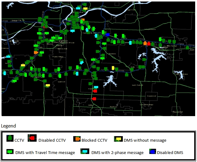
Photo Credit: KC Scout ATMS Screenshot
2.3 Geographical Representation of Scout Coverage Area
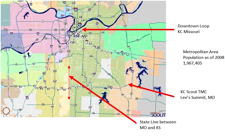
Photo Credit: KC Sout ATMS Screenshot
2.4 Jurisdictional Coverage
Kansas City Scout encompasses the jurisdictional boundaries of Cass, Clay and Jackson counties in Missouri and Johnson and Wyandotte counties in Kansas. Population for those respective counties is as follows:
County |
State |
Population |
|---|---|---|
Cass |
MO |
95,781 |
Clay |
MO |
206,957 |
Jackson |
MO |
664,078 |
Johnson |
KS |
516,731 |
Wyandotte |
KS |
155,509 |
Source: http:\\metrodataline.org/xls/population/Population_Estimates_as_of_July_1.xls
2.5 Average Annual Daily Traffic (AADT)
Figure 2.5 shows AADTs for the freeway facilities on the Scout system. The number of incidents on each facility generally correlates with the AADTs for that facility.
Figure 2.5 AADT Data as of September 2009
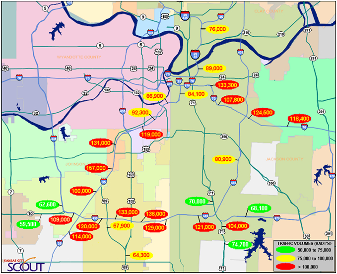
Photo Credit: KC Scout September 2009 Monthly Report, published on the web at www.kcscout.net
Note: The I-70 interstate reaches across Missouri from the Illinois state line to the Kansas state line. It is the nation’s fifth largest east-west corridor, passing through 10 states from Maryland to Utah.
Source: http://www.modot.org/interstate/
2.6 Current Levels of KC Scout Staffing
KC Scout has maintained 24/7 operational hours since July of 2005. Staffing levels vary between three shifts (6A-2P; 2P-10P and 10P-6A). Peak hours are staffed with a minimum of two operators and one floor supervisor. Due to the collocation of MoDOT’s Customer Service department within the TMC, information relayed via the public is also readily available to Scout operations.
Additionally, KC Scout is supported on both sides of the state line by Motorist Assist operations. They provide on-the-road assistance to motorists needing help with flat tires, low fuel, etc. and actively patrol the interstates looking for road hazards, tagging abandoned vehicles, and assisting with traffic control on incidents where lane restrictions have occurred due to stalls, accidents, traffic stops or weather impacts, such as flooding, ice covered bridges and overpasses, and debris from storm related events.
2.7 Historical Weather Events for the Coverage Area
Accessing the National Climatic Data Center (NCDC), an application within NOAA’s website, enables access to archived 50-year storm event data, by state and county. This information is limited in accuracy due to the non-mechanized collection of data prior to the mid-1990s, but it is indicative of the weather events experienced throughout our region within the historical context of a 50 year sample.
Source: http://www4.ncdc.noaa.gov/cgi-win/wwcgi.dll?wwEvent~Storms
2.8 Weather Information Integration Sources
Current sources of weather information readily available to all KC Scout operators include:
- 138 CCTVs on Scout’s network
- Internet access to NOAA, the Weather Channel™ and other 3rd party sites
- Local weather/news broadcasts on desktop monitors
- Police & fire radio scanners
- Emergency weather radio
- Missouri state DOT radio communications
- Email from State Emergency Operations Coordinators in both Missouri and Kansas
2.9 Existing Public Weather and Traffic Information Systems
There are numerous sources of publicly available weather and traffic management information and decision-support systems in our region accessible via the Internet. The following is a list of organizations and media outlets that provide website weather and traffic information for the Kansas City area:
- KDOT
- MoDOT
- KC Scout
- NWS and the Weather Channel
- ABC
- CBS
- NBC
- FOX
Each of the four national television network affiliates use Scout’s branded CCTV images to provide real-time information about current roadway conditions during their local drive-time news broadcasts. These links are provided via direct fiber optic connectivity to our CCTV network. Camera control rests solely within the TMC.
2.10 Area Traveler Information Websites
KDOT and MoDOT maintain websites that feature weather components. KC Scout’s website posts a current forecast widget along with a link to the Weather Channel.


Source: http://511.ksdot.org/KanRoadPublic_VE/Default.aspx
Source KC Scout Fleetpoint™ desktop screenshot: http://maps.modot.mo.gov/travelerniformation/travelerinformation.aspx
Figure 2.10.3 Kansas City Scout Website – Source: www.kcscout.net
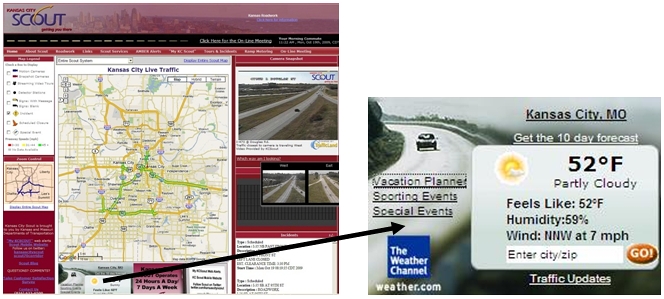
Currently, there are no mandated procedures for Scout operators to follow when severe weather occurs in the area. However, operators are extremely self-motivated and encouraged to use whatever tools are available to actively assess weather conditions and their forecasted impacts on our monitored roadways.
2.11 Impacts of Weather Events on KC Scout’s Operations
KC Scout’s coverage area is at the very crossroads of the nation’s network of interstate highways with 105 miles of monitored, contiguous roadways carrying high volumes of commercial, commuter and non-local motorists. Therefore, any weather conditions that affect the highways become of critical importance in terms of congestion, accident response, emissions, and driver impatience.
During winter storm events, MoDOT’s traffic department staffs a separate workstation within the TMC, solely for the purpose of monitoring road conditions and reporting on the snowplow activity within its local coverage area. This is of extreme assistance to KC Scout operations because the information can be used to post DMS messages in advance of the plows, helping to keep those lanes clear of through traffic that would otherwise impede plowing activity.
2.12 Internal TMC Weather and Transportation Management Systems
In addition to information obtained via Internet and 3rd party sources, KC Scout relies heavily on its extensive network of CCTVs and first-hand reports of roadway conditions reported by Motorist Assist operators patrolling their respective zones. MoDOT maintenance crews also report road conditions via radio communications which are actively monitored within the TMC.
2.13 MoDOT Motorist Assist
During the AM and PM peak traffic periods, KC Scout operators dispatch five (5) Motorist Assist (MA) operators, supported by a supervisor and Incident Management Coordinator, throughout the Missouri portion of Scout’s coverage area. These operators patrol designated routes to assist motorists and report back to the TMC any traffic conditions that warrant close monitoring. Between 8 PM and 5 AM, two (2) Emergency Response (ER) operators patrol the Missouri portion and respond on incidents, primarily to provide traffic control for law enforcement activity on the Scout monitored roadways.
Currently, MA & ER responder vehicles are equipped with AVL (Automatic Vehicle Location) technology enabling TMC operators to monitor vehicle location, speed and direction of travel and sensor status of strobe and arrow board lights. Fleetpoint™ software on the desktop gives TMC Operators a quick, visual reference of all units, whether moving or stopped.
Figure 2.13.1 Fleetpoint™ Mapping Software
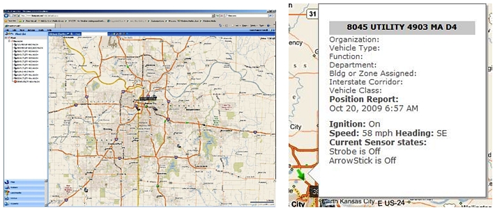
Source: http://www.fleetpoint.net/WEB/default.aspx
At present, these MA/ER vehicles are not yet equipped with RWIS (Road Weather Information System) technology, but that is an option currently being tested by Gateway Guide™, the ITS system operated by MoDOT in the greater St. Louis area. A single MDC (Mobile Data Computer) device is being installed on one of the Motorist Assist Supervisor vehicles which patrols between 5AM and 8PM Monday-Friday. Based on the results of these pilot studies, KC Scout Motorist Assist will likely be deploying road condition gathering sensors on its entire fleet in 2010. This collected data will then be made available to MoDOT maintenance crew chiefs for the purpose of coordinating treatment activity as conditions warrant. This data will be provided via MoDOT’s intranet web application which permits access from home PCs as well as at district headquarters.
2.14 MoDOT Maintenance Crews
During the winter months, maintenance and field crews regularly report road conditions every 2-4 hours depending upon whether an “event” is in progress, which are then posted on both MoDOT and Scout websites. Because MoDOT’s Customer Service department is collocated within the TMC, KC Scout benefits from these early reports which are often the basis for initiating weather condition notifications. MoDOT subscribes to “WeatherOrNot” for its forecast information statewide. During winter storm events, regularly scheduled “Situation Awareness” conference calls are held 2-3 times daily (8:00 am / 2:00 pm / 5:00 pm). All districts are represented and report on current road conditions, air and surface temperatures, sand/salt reserves, numbers of vehicles in service and posted weather message plans. In addition to MoDOT Maintenance personnel, these calls also involve representatives from Motor Carrier Services, Public Affairs, Information Services, National Weather Service and State Emergency Management Agency representatives.
2.15 KHP Motorist Assist Vehicles (MAV)
Roadside assistance is provided in Kansas by the Kansas Highway Patrol. Currently, KHP maintains four vehicles with 8 designated operators who cover 123 miles during day and evening hours. KC Scout operators monitor KHP radio communications and report incidents verified on camera to KHP’s Salina, KS dispatch center. Reports on road conditions from enforcement and field crews are closely monitored by TMC operations staff.
2.16 RWIS (Road Weather Information System)Deployment
Remote RWIS sensors measure air temperature, humidity, visibility, wind speed and direction, pavement temperature and surface conditions. Such data is used for winter maintenance and travel information. Units are generally deployed onto fixed infrastructure like poles, bridge overpasses, etc. Additionally, mobile units can be deployed along with AVL on maintenance and responder vehicles to return real-time road condition data to a centralized data receiving station to facilitate immediate maintenance and operational response.
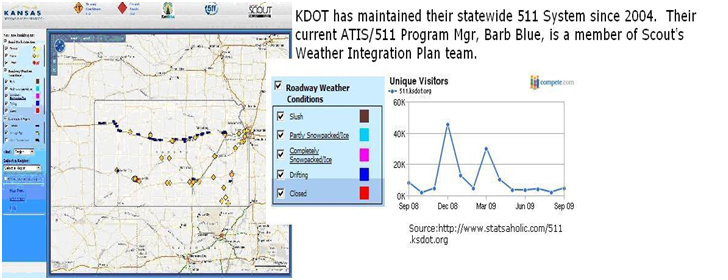
2.16.1 RWIS in KANSAS
KDOT, at present, has no RWIS stations deployed in the greater metropolitan Kansas City area. The closest are just outside the boundaries of Scout’s coverage. Currently, select KDOT maintenance vehicles are equipped with air and pavement temperature sensors. However, the environmental data collected is stored on board and is not sending to any receiving site in real time or near real time. A project is underway to equip maintenance vehicles with communication capabilities to transmit the data in real time. This project will be implemented in two phases. Phase 1 of this project will install communications on three maintenance trucks in a district. The data collected by the vehicles will be transmitted in real time to a receiving site where the data is integrated with RWIS data. The benefits of the system will be evaluated. Phase 2 of this project will expand the system.
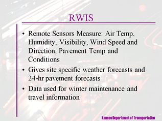
Figure 2.16.1 Source: http://www.ksdot.org:9080/burTransPlan/burovr/its/PDF/Dist4ITSAwarP.ppt#338,15,RWIS
2.16.2 RWIS in MISSOURI
MoDOT D4 which encompasses the KC Scout coverage area, has had RWIS deployed for many years, but the equipment is out-of-date and has not been maintained. These legacy units were scheduled for replacement within FY 2010, however that plan has been put on hold for budgetary reasons. New RWIS devices are being added to the KC Scout network within planned expansion projects as part of new construction. This is addressed more fully in Sections 7 and 8 of this document.
2.17 Other Scout Integration Efforts – Ramp Metering Began November 20, 2009
The effort to implement Ramp Metering in the metropolitan KC area has been under evaluation for nearly ten years. A year-long effort to gain the public’s acceptance of ramp metering was tested in mid-November, 2009, when ramp metering began on a stretch of I-435 between Kansas and Missouri as a pilot project. This high profile implementation represents a huge level of effort on the part of Scout’s management team members who participated in public meetings, work place lunch-and-learn sessions for businesses located along the affected corridor and answered volumes of emails from the public in response to a well executed media campaign.
To date, the project has been well received. Data is being analyzed to determine the impacts on traffic throughput during the morning and evening peak periods, the only hours the meters are in operation. Scout intends to present a session on the success of Ramp Metering at this year’s ITS Heartland Conference in Omaha, NE March 29-31st, 2010.
2.18 Other MoDOT Weather Integration Efforts – Solar Bridge Warming System Initiative
In January 2010, MoDOT became one of the first agencies in the country to consider using solar energy to combat buildup of snow and ice on bridge decks. Pave Guard Technologies, Inc. of Lee’s Summit, MO was contracted to install a “solar warming system” on two bridges in District 4. The bridges selected in Clay and Ray Counties are scheduled for deck replacements in 2010 as part of MoDOT’s “Safe & Sound Bridge Improvement Program” that is repairing or replacing 802 of the state’s worst bridges by the end of 2013.
The warming system operates similar to the way in which radiant heating warms home flooring. Tubing is installed in the bridge deck, through which a heated solution is pumped to keep the deck from freezing. The energy to heat the solution is provided by solar panels mounted near the bridge site. Excess energy produced by the panels when the heating system is not in use can be sold back to local utilities. Bids were let for this construction activity in February 2010, with construction scheduled between April and August of 2010 with target operability by November 2010. MoDOT will evaluate the performance of the systems before making a decision on whether to extend deployment to other bridges.
2.19 Other KDOT Weather Integration Efforts – Wind-Induced Truck Crash Study
In 2009, KDOT contracted with the University of Kansas to conduct a study on predicting and mitigating wind-induced truck crashes on I-70 in Kansas. Interstate 70 was selected for this detailed analysis in conjunction with KDOT’s plan to deploy DMS boards between Topeka and the Colorado border. The evaluation consisted of a literature review and analysis of wind-related crashes throughout Kansas over the 3 year period from 2005 to 2007 along with independent weather data. Data was analyzed to determine the correlations between the vehicle characteristics, crash occurrences and weather conditions. The goal was to construct a model that could predict the likelihood of such wind-induced truck crashes, thus providing a tool for increasing safety for both truck drivers and the traveling public. Such crashes often result in interstate closures, creating significant delays and economic loss.
The western and central parts of the state are prone to severe crosswind conditions that result in traffic crashes involving commercial freight or high-profile vehicles. Interstate 70 extends from the western border to the eastern border, covering 424 miles and passes through many of the state’s largest cities. The I-70 corridor carries an average annual daily traffic (AADT) of 7,990 to 20,300, of which 2,990 to 4,100 are tractor/trailer commercial vehicles.
The findings of the study were consistent with other agency findings with a notable observation: neither wind speed nor wind gust speed was found to be a factor. More statistically significant were the presence of a thunderstorm, the western most mileposts carrying most risk, presence of concrete pavement and the physical profile of the commercial vehicle. In general, the crash data indicated that Kansas cross-country commercial drivers do alter their driving behavior when winds gust above 40 mph.
3.0 CONCEPTS OF OPERATIONS
There are a variety of regional stakeholders that include maintenance and construction operations, emergency response management, commercial vehicle operations, media partners, and 3rd party data providers who benefit from the information they obtain via the TMC. Weather conditions throughout the year are a significant component, especially during spring thunderstorms and seasonal flooding episodes. During a typical winter season, the area experiences frequent snow storms and disabling ice events which close roads, disrupt local electrical service and impede emergency response to incidents.
3.1 Maintenance and Construction Management
These departments manage fleets of maintenance, construction, or special service vehicles (e.g., snow and ice control equipment). These organizations also participate in incident response by deploying maintenance and construction resources to an incident scene, in coordination with other agencies. Winter weather in our area demands a unified and planned response. Preparation and training begins early in the fall for road and equipment maintenance crews. Missouri state radio systems within the TMC are checked and calibrated for optimal performance. Personnel are assigned and pagers are distributed to those who will be monitoring road conditions during winter weather events. The winter weather season officially begins October 15th and runs until April 15th.
3.1.2 MoDOT Performance Measurements
One of the significant weather operational goals to which MoDOT management is held accountable is “Time to meet winter storm event performance objectives on major and minor highways.” Data is collected in the winter event database, and analyzed so that improvements can be made. After each winter event, such as a snow or ice storm, area maintenance personnel submit a report indicating how much time it took to clear snow from the major and minor highways. Data collection for this measure runs from November through March of each winter season. After a storm ends, the objectives are to restore the major highways to a clear condition as soon as possible and have the lower-volume minor highways open to two-way traffic and treated with salt and/or abrasives at all critical areas such as intersections, hills and curves as soon as possible. The end of the storm is defined as when freezing precipitation stops accumulating on the roadways, either from falling or drifting conditions. This data is updated in January and April Management reports.
In 2008, there were two winter events in November and nine in December. The Kansas City district received, on average, between seven and ten inches of snow. The average time to meet the performance objectives on the major highways varied from 2.9 to 3.7 hours over the reporting period. The average time to meet the performance objectives on the minor highways varied from 3.8 to 5.3 hours. Current strategies to improve these numbers include pursuing equipment enhancements, testing new materials and continued reliance on verifiable advance weather notification.
3.2 Emergency Management Agencies
KC Scout interfaces with 57 local area law enforcement and fire department agencies. Operators monitor scanners within the TMC as well as receive calls directly from public safety agencies via a dedicated law enforcement hotline. Relationships with law enforcement personnel have improved dramatically due to the proactive efforts of Scout’s Incident Management Coordinator, who spent 30 years as a traffic control specialist with the Lenexa KS Police Department. Through joint efforts, we now have a signed cooperative accord with these agencies to work together to improve the safety and efficiency of our shared urban transportation systems and support the continued economic growth in the region.
3.3 Commercial Vehicle Operations
The configuration of eleven major transportation routes monitored by KC Scout is highly utilized by commercial carriers. When road conditions or incidents cause any of the interstate routes to be closed in one direction for greater than two hours, it is Scout’s policy to notify Motor Carrier Services (MCS). They in turn, notify their network of commercial carrier contacts to limit the disruption caused either by detour routes or the carriers own decision to wait out the closure. In the case of weather related closures, this can quickly become a problem for urban arterial roads not equipped to handle the commercial traffic, compounded by local jurisdiction efforts to keep those roads open and clear. Advance planning for weather events is therefore of critical importance to traffic managers, commercial carriers, emergency responders and the general public.
3.4 Media Partners and 3rd Party Providers
KC Scout interfaces with a number of media partners who relay information received from Scout to their own subscribers. As social networking sites have gained in widespread popularity, KC Scout has incorporated them into their outbound information stream. Such sites as Twitter™ and Facebook™ now carry KC Scout incident messages to an even wider audience. In situations of severe weather, these sites become highly useful to motorists seeking the latest information on road conditions.
Scout’s own website (www.kcscout.net) incorporates a 3rd party application entitled “MyKCScout” allowing subscribers to create a customized alert notification for their specific route(s) of choice, by day-of-week, time-of-day and type of notification (email or instant text message). Users can opt to include weather alerts, homeland security alerts, Ozone and Amber alerts. In this way, KC Scout enables use of “push” technology to disseminate immediate information regarding conditions that affect the traveling public.
3.5 TMC Desktop Applications
Each operator position is equipped with four (4) monitors; one 19”, two 17” and one 15”. Operators have the flexibility to configure their workstations to their own preferences, but desktop real estate is extremely limited due to the number of active windows required for day-to-day monitoring and incident management. It is customary for a user to constantly toggle between 10-12+ open windows, among the four available monitors, throughout a typical work shift. By integrating weather information into our existing processes, it will provide smoother flow between applications, more timely response to changing conditions and improved proactive decision-making based on readily available, real-time data.
4.0 RELATIONSHIP TO OTHER PLAN DOCUMENTS
MoDOT and KDOT planning organizations contribute to the overall KC Scout ITS architecture plan under guidance from the Scout Board of Directors, the TMC Manager and Scout Project Manager.
4.1 MidAmerica Regional Council (MARC)
Mid America Regional Council (MARC) is a nonprofit association of city and county governments and the area MPO (Metropolitan Planning Organization) for the bi-state Kansas City region. Governed by a board of local elected officials, MARC serves nine counties and 120 cities and is a strong supporter and contributor to KC Scout, holding a seat on the Board of Directors.
4.2 Operation Green Light (OGL)
Operation Green Light (OGL) is an initiative within MARC to coordinate arterial traffic signal timing plans across 20 jurisdictional boundaries in Kansas and Missouri. The project built an extensive wireless communication system to 633 signals across the region to allow for signals to be better coordinated and respond to problems in real time. Of the 633 signals in Phase 1, nearly 90 percent are online and almost 80 percent have new timing plans during peak travel periods.
Benefits in specific corridors have resulted in a 21 percent decrease in travel times; an 18 percent reduction in fuel consumption; and a 15 percent decrease in emissions. Operation Green Light's real-time computer systems allow staff to investigate signal problems and change signal timing without field visits. Analysts can also manage many problems in real time rather than waiting for a citizen complaint.
Currently, OGL operates out of MoDOT D4, separate from KC Scout. However, integration is in the initial phase with an OGL workstation operational within the TMC. Efforts to integrate arterial with freeway ATMS are in the planning stages. Both OGL and KC Scout use TransSuite™ ATMS applications which enhances the potential of a successful integration effort.
5.0 WEATHER INTEGRATION SELF-EVALUATION PROCESS
As noted in the chart provided in the Acknowledgments section of this document, the members of the KC Scout Weather Integration project team constitute a diverse cross-section of transportation and weather professionals. Operations and maintenance are represented along with TMC staff and outside agency professionals.
5.1 Initial Strategy for Determining Geographic Scope of the Project
KC Scout’s unique bi-state characteristics determined the geographic scope of this project. It was decided by the team that the current physical boundaries of Scout’s CCTV/DMS/VDS coverage areas would be a logical integration target. Major expansion efforts are in the planning and construction stages in both states that will extend the scope of the current network. These initiatives involve the placement of CCTVs along the I-70 corridor between Kansas City and St. Louis as an enhancement to the 20 CMS boards (10 each, East and West) that KC Scout now manages as part of its operation. Similarly, KDOT is deploying cameras and DMS boards along their portion of I-70 all the way across the state to the Colorado border. These will eventually be monitored by KC Scout. The year-round weather characteristics are fairly uniform between both states, so there was no need to break out each as a separate zone for assessment purposes.
5.2 Initial and Subsequent Self-Evaluations using the Electronic Guide
It is worth noting that our team conducted an initial and subsequent self-evaluation using the Electronic Guide. Our first effort in June of 2009 took approximately 4 hours to conduct since there was limited consensus among the TMC staff participants as to the type and frequency of weather events experienced in our area and our current levels of integration.
Upon completion of the initial assessment, the Guide yielded a total of thirteen High Need Strategies. Output reports were distributed to team members for review and further discussion. Once reassembled, the internal team concluded that the results underestimated the current level of integration due to the extensive number of high need strategies identified by the Guide. When the full project team met again with the Battelle consultants on August 12, the problem was presented for discussion and it was recommended that we re-run the assessment tool with an eye on reducing the 13 high-need target strategies by 50% to yield a more reasonable integration plan goal. That effort took less than 30 minutes and quite surprisingly, revealed that the initial assessment actually “overstated” Scout’s current level of integration. The target “high needs” were reduced from the original thirteen down to six, which is a far more realistic integration goal.
5.3 Guide Recommended Target Strategies
The Guide’s design encompasses five specific dimensions of integration: Operational, Physical, Technical, Procedural and Institutional. Within these dimensions, there are 11 Items of Integration that make up the Self-Evaluation. The following chart reflects the criteria for each level of integration:
The output results of the KC Scout self-assessment evaluation are discussed in detail in Section 7 of this document. Reports from all five sections of the Guide are included in the Appendices.
5.4 Six Scout Identified High Needs Target Strategies
The six High Needs target strategies that became the focus of this Integration Plan document are as follows:
- Disseminate weather information to a larger set of stakeholders and users in the region (including transit and other modes)
- Provide better enroute information on weather conditions to aid travelers in their decision-making
- Develop and implement clear, written policies and procedures for handling weather events
- Improve the timeliness of weather management response including deployment of field personnel and equipment
- Provide assistance in interpreting weather information and how best to adjust operations in light of that information
- Create better real-time information on road conditions during weather events
The above strategies are discussed specifically in Section 6 of this document. Our ability to proactively utilize real-time weather information to enhance advisory notification to the travelling public, field maintenance and operations staff as well as our media partners, will extend Scout’s value far beyond its current level of reactive response.
6.0 INTEGRATION NEEDS
By design, the Self Evaluation Electronic Guide incorporates a base of eleven items of integration that represent best practices from various TMCs that participated in the initial FWHA/Battelle pilot study.
6.1 Eleven Items of Integration
- Use of Internal Weather Information Resources
- Use of External Weather Information Sources
- Availability of Weather Information
- Frequency of Weather Forecasts
- Frequency of Weather/Road Weather Observations
- Weather Information Coordination
- Extent of Coverage
- Interaction with Meteorologists
- Alert Notifications
- Decision support
- Weather/Road Weather Data Acquisition
Each of these 11 Items of Integration was then categorized into five levels of integration, ranging from minimal to maximum integration as shown in Figure 5.3.1 in the previous section.
6.2 Five Categories of Integration Needs
Section 4 of the Electronic Self-Assessment Guide elicited responses that identified TMC Operational Needs, ranging from low to medium to high, which then fell within five specific categories, as follows:
- Advisory functions (relating to a TMC providing travel advisories during a weather event)
- Institutional coordination (relating to coordinating within and outside a TMC)
- Control functions (relating to the control functions of a TMC during a weather event)
- Treatment functions (relating to road treatment functions for a TMC during a weather event)
- Weather information gathering (relating to obtaining better weather data and information)
6.3 Scout’s Identified “High Level Needs”
Scout’s results from the self-assessment exercise produced the following six “High” level needs and their respective categories. Note: Control Functions did not produce an output need since the focus of KC Scout’s TMC is to provide information, not necessarily exercise control functions other than those associated with information response, notification and monitoring activity.
6.4 Advisory Operations Needs
Weather information is currently gathered from available sources, but it is not integrated into TMC operator desktop applications. This therefore requires that an operator “open” an Internet Explorer window to gain access to the Internet. Each separate window requires valuable desktop real estate on the current 4-monitor screen configuration at the workstation. This becomes a juggling act to keep the information readily accessible while not interfering with ATMS functionality.
In order to meet the need “to disseminate weather information to a larger set of stakeholders…” it is first necessary to improve the means of obtaining this information and integrating it into those applications which drive our notification processes.
Similarly, in order to meet the need “to provide better enroute information on weather conditions…” Scout must first receive weather forecast information that is highly reliable, verifiable and time-based so as to be of use to motorists currently on the roadways or those planning imminent travel through the area.
6.5 Institutional Coordination
The need to develop and implement clear, written policies and procedures for handling weather events is of extreme importance to our 24/7 operation. KC Scout operators come from a wide variety of backgrounds and transportation experience levels. Not all of them have the same “Employer of Record” given the mix of MoDOT, KDOT, KHP and contractor staffed positions. In order to maintain a high degree of consistency within TMC operations, it is essential that policies and procedures be communicated clearly and frequently.
Training is an ongoing TMC function. Toward that goal, KC Scout has developed a comprehensive Operator Certification program that assures a continuum of training. This Weather Integration Plan will become a component of that certification program upon its completion.
As a bi-state managed TMC, Scout maintains a unique organizational structure with oversight by both DOTs. This requires a high degree of coordination and cooperation between all parties. Weather is a common entity, but how we manage it may differ by organizations. Thus, having a Weather Integration Plan developed by representatives from the various stakeholders should prove invaluable to our TMC.
6.6 Treatment Operations
Maintenance Operations and the TMC are entirely separate entities. Day-to-day maintenance and construction activities are communicated via written RoadZone reports issued by both DOTs, via email, with the next day’s planned work zones. These communications are issued from the Community Relations departments and go to both internal and external recipients. In the event of a weather event, these work zones are noted as “weather permitting.”
During winter weather season, there is a closer relationship between maintenance operations and the TMC. During an event that requires the use of snow plows, salt trucks and specialized maintenance vehicles, the traffic department at MoDOT staffs a workstation within the TMC to monitor the clearance activity, stay apprised of changing conditions via the CCTVs and weather forecast information available within the TMC and upload road information into the MoDOT Traffic Management System (TMS). This database populates the road condition information available on the MoDOT website Traveler Information Map.
Improved coordination with maintenance efforts may be the biggest opportunity for integration and also the most difficult, given the diverse culture between maintenance operations and the TMC. By sharing weather information and observations with field personnel, the TMC can help them with visual confirmation of the roadway conditions and by integrating weather elements into our notification system, keep them better apprised of changing conditions during an event. Similarly, direct communication from field personnel regarding observed changes in road conditions can be the first indicator of weather situation impacts. Open communication between departments is the desired outcome of any integration effort.
KC Scout now provides Missouri road condition information to motorists via HAR updates utilizing software that interprets written scripts to deliver the most current information. This information is updated no less than four times every 24 hour period or as changing conditions warrant. Once maintenance personnel update the MoDOT website map indicating current road conditions, a Scout operator updates the text-to-voice script and uploads the revisions to the HAR application.
6.7 Weather Information Processing and Gathering
Within our TMC, we have several individuals with prior experience interpreting weather data. One of our full-time operators serves in a part-time capacity as an Administrative Officer for Missouri Disaster Medical Assistance Team. His role is to monitor and report on current weather activity once his unit is activated. His past experience involved on-scene disaster response when the western Kansas town of Greensburg was devastated by an F5 tornado on May 4, 2007. Two other full-time operators had previous careers in Emergency Dispatch, one a 30 year veteran 911 dispatcher and another with 15 years Fire dispatch background. Both TMC supervisors have backgrounds in Fire and 911 dispatch respectively. This heightened level of emergency management expertise serves our department well. However, we could do a better job of educating all TMC staff on weather information interpretation.
By integrating weather information into our ATMS application, we would reduce the margins of error in interpreting data and be better equipped to issue advance warning notifications utilizing our DMS network and outbound communication sources. Maintenance functions could potentially be linked to the weather components of our ATMS to enable better manpower and equipment scheduling during significant weather events.
7.0 INTEGRATION SOLUTIONS
Completion of Section 5 of the Self-Evaluation Guide yielded a set of Target Strategies that identify the delta between where we are now and where we want to be in terms of weather information integration. Those results are shown in the figure below, with shading to represent the identified current versus recommended level of integration.
7.1 Use of Internal Weather Information Resources
At the current integration level, KC Scout is positioned within Levels 1 and 2 which include our network of 138 CCTVs and available radar and satellite information obtained via the Internet to identify active and forecasted weather conditions. To reach our target of Level 3 integration, we will be adding new RWIS functionality by deploying six (6) new RWIS devices within the current Scout construction schedule for three planned expansion projects along I-29/I-35, I-435 and US 71 Hwy. These projects are in various stages of construction and all will be completed by 2011.
MoDOT has a number of installed but depreciating RWIS devices which will ultimately be replaced at some point in the future. These units have not been maintained over time and discussions with Maintenance have determined where legacy unit replacements should be installed to provide maximum monitoring of road conditions at sites where numerous accidents are known to occur, principally near bridges, overpasses and high water areas. In addition, Scout has recommended locations that also provide CCTV monitoring functionality.
By opting to include RWIS within new construction projects, KC Scout takes advantage of the new power and cabinet installations and simply adds the necessary RWIS hardware as a component. This results in shifting the cost from an already tightly restricted operating budget to funds already pre-approved for construction activity. Use of this additional data element will involve operator and support services training. This will become part of the Operator Certification Training Program with coordination and train-the-trainer sessions furnished by the selected vendor. Procedures will need to be developed to report and troubleshoot any malfunctions within the RWIS data link. As an added internal feature of KC Scout, a public relations campaign may be developed to promote awareness of the RWIS upgrade and the additional road condition information that it will provide to the public. Scout has its own Community Relations Specialist assigned to developing and managing these types of public relations campaigns which include press releases, website announcements and public meetings as required.
7.2 Use of External Weather Information Resources
Scout’s current use of internet and broadcast media-provided weather information will be improved to Levels 3 and 4 (and possibly 5) by incorporating data interconnection links between the TMC and NOAA’s Pleasant Hill Weather Forecasting office. Efforts are currently underway to integrate the data elements necessary to populate Scout’s ATMS mapping application with polygonal link layer(s) that would automatically display as a layer on the ATMS map application when weather conditions reached pre-determined thresholds across the TMC coverage area. This would trigger planned notification messaging via the DMS and outbound web links as well as internal notifications to DOT maintenance and construction personnel. Alert notifications are discussed further in Section 7.9.
Training, support and procedural policies will need to be developed, tested and published. Activity resulting from this enhanced level of integration would need to be tracked, measured and analyzed to gauge its effectiveness in reducing traffic impacts associated with severe weather events.
7.3 Availability of Weather Information
Ad-hoc operator usage and video wall display of internet (radar and satellite) image information will be replaced with inbound and integrated road/driving condition reports received via RWIS, mobile data computer (MDC) and field reporting personnel. The same factors of training, support and policy development will be expected to accompany this level of integration. A higher degree of interdepartmental communication between the TMC and Maintenance will be necessary to achieve full benefit of this solution, in terms of advisory and treatment management decisions.
7.4 Frequency of Weather Forecasts
No marked level of change is required here, particularly since implementation of the above strategies will integrate forecast data into TMC standard operations, making it a “push” rather than “pull” data element.
7.5 Frequency of Weather/Road Weather Observations
Frequency is less a concern, since the information will be inbound on an ongoing basis. Reports on these new data elements will need to be developed so that results can be measured and tracked.
7.6 Weather Information Coordination
By virtue of this Weather Integration Project, our TMC has already convened an “Intra-TMC committee” to promote weather information coordination across all partner channels. It is Scout’s expectation that this committee will continue to meet on a bi-annual (or seasonal basis) to revisit the Plan, make new recommendations based on developing technologies and involve new stakeholders as roles and responsibilities change.
As champion of this initial integration effort, TMC Supervisory personnel will function as committee chairperson(s) and facilitators for ongoing integration activity.
7.7 Extent of Coverage
This solution is an outgrowth of the RWIS and AVL deployment strategies already discussed. Scout initially identified specific locations that would warrant installation of updated RWIS data collection technology such as high-water collection points, bridges and overpasses, and segments of the monitored roadway that habitually are the site of incidents during inclement weather. However, it was decided to forego those locations in favor of installing RWIS as part of the construction efforts for three (3) pre-approved KC Scout Expansion projects. This enabled funding for RWIS to be included within current construction budgets taking into consideration planned power and cabinet installation. Only the RWIS devices themselves and the software required to operate them will need to be purchased. It is estimated that the initial cost to deploy six (6) new RWIS remote side-fire devices along three expanded corridors will be approximately $55,000 with maintenance provided by the vendor at a cost of $3-4K each per year. Maintenance and response vehicles equipped with AVL/MDC sensor technology will provide “roaming” sources of road condition data.
In terms of corridor level coverage, Scout’s TMC will still be dependent upon notification by field personnel when road conditions deteriorate due to weather, particularly when those locations are outside the CCTV scope of coverage. For the entirety of the Missouri I-70 E/W corridor, KC Scout currently has responsibility for activating DMS message boards when capacity is reduced due to incidents and/or roadwork. This area of responsibility is being enhanced by the addition of CCTV cameras near the twenty DMS boards along I-70. Initially, KC Scout will have view-only capability with camera control retained by maintenance management. This is a part of a Missouri statewide effort to deploy Omnicast™ technology for CCTV coverage of critical intersections on major and minor highways. Scout supervisory personnel have already participated in training sessions for the new software, which is being installed and tested throughout the state. It is expected that this additional ITS deployment will be fully functional and available for operator training after July 1, 2010.
Further, KDOT has designated Scout as a backup TMC for activation of their DMS during severe weather events along the I-70 corridor from the Missouri state line to the Colorado border. This effectively expands Scout’s extent of coverage to span Interstate 70 from Illinois to Colorado.
7.8 Interaction with Meteorologists
Scout is fortunate to have a regional NOAA/Weather Forecasting Office, located less than 10 miles from the TMC. Two of this Plan’s team members are NOAA meteorologists: Julie Adolphson, Meteorologist In Charge, and Andy Bailey, Warning Coordination Meteorologist. We share a mission to utilize technology to save lives. To date these individuals have participated in this integration project in an advisory capacity. They have furnished the necessary technical information for our software vendor to build-in the geo-coding necessary to integrate NWS data elements into Scout’s ATMS. We are in the process of identifying the pre-determined weather event “thresholds” that would warrant notification passing from NOAA in the form of data “tags” directly into the ATMS layer to prompt an operator to activate a “weather incident” following the same procedures now used for traffic events. As recently as October 22, 2009, an article appeared in the Hutchinson KS newspaper lauding the number of lives saved in the May 4, 2007 Greensburg, Kansas F5 tornado, due to science and technological advances that provided early warning notification. Eleven deaths were attributed to the 1.7 mile wide tornado which hit the town at 9:55 pm and destroyed virtually every building. Without Doppler radar and experts assessing the path of the storm and issuing warnings, it is estimated that the death toll could have easily reached into the hundreds. For a link to the article, go to http://www.hutchnews.com/Print/weatherman.
7.9 Alert Notification
This integration solution will be achieved by progression from passive weather monitoring within the TMC to automatic alert notification via TMC standard operating procedures, just as we now treat incidents of any nature that impact the capacity of the roadways.
Currently, KC Scout provides electronic alerts to subscribers of “MyKCScout” via the Scout website. Subscribers create password protected “Custom Trip” profiles for specific day of week, time of day and route criteria. MyKCScout alerts are then generated automatically and sent as email and/or text messages when incidents meeting user-specified criteria are initiated. Weather alerts are selectable options and the data is automatically sent from the National Weather Service (NWS) when issued. This involves no interaction on the part of TMC operators to create or cancel such alerts.
Figure 7.9.1 Customized Alert Entry Screen
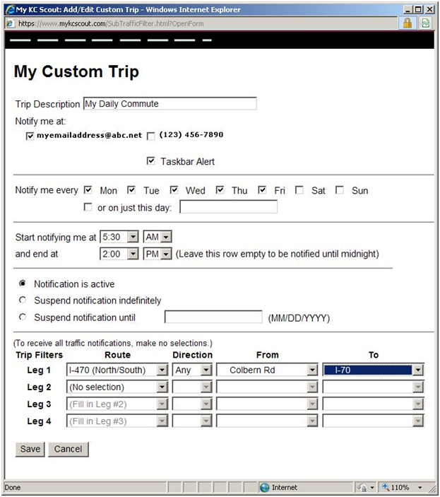
Photo credit: Screenshot of myKCScout Custom Alert Profile, available to subscribers through KC Scout's website: http://www.kcscout.net
Figure 7.9.2 Activation of Weather Alert Filter
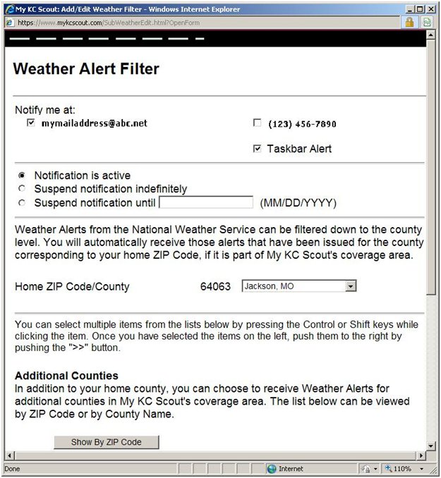
Photo credit: Screenshot of myKCScout Custom Alert Profile, available to subscribers through KC Scout's website: http://www.kcscout.net
Expanding the audience for TMC issued weather alerts will require the identification of key personnel along with their preferred notification method (email, text, phone, etc.). Scout currently maintains a similar type of notification methodology for any incidents involving lane restrictions along the I-29, I-35 and I-70 corridors. Operators complete an information datasheet upon notification of an event/incident on the corridor and then this information is posted on the respective DMS board(s), added into the Traveler Information Map (if the duration is anticipated to exceed 2 hours) and an email is sent to a group list of over 100 MoDOT personnel. Any updates or changes are similarly communicated and a clearance email is also sent.
7.10 Decision Support
Scout will develop response scenarios with recommended advisory messages upon receipt of developing weather condition information. The predetermined “thresholds” are in the process of being defined and policy and procedure guidelines will need to be written. This represents a significant new effort for the Scout Management team. It is our firm policy to have any and all operational changes approved by Scout’s Board of Directors. Institutional changes represent the greatest challenge and will require the most time to implement.
7.11 Weather/Road Weather Data Acquisition
As discussed in early sections, RWIS and AVL/MDC technologies are currently being planned or considered for deployment in Scout’s coverage areas. On the MoDOT side, replacement RWIS installation and maintenance costs will be incurred by Maintenance, with Scout paying only for the monthly recurring data delivery costs. Current estimates indicate an initial capital investment of approximately $70,000 for 8 planned stations with $4,000 per year for five years for maintenance once funding becomes available.
Currently, KDOT maintenance vehicles are equipped with air and pavement temperature sensors. However, the environmental data collected is stored on board and is not being sent to any receiving site in real time or near real time. KDOT has a current project (ITS-14) to equip maintenance vehicles with communication capabilities to transmit the data in real time. This 2-phase project will involve the integration of this data with RWIS data to provide improved road weather information and environmental conditions monitoring. Since no RWIS stations are deployed within Scout’s Kansas coverage areas, any data received regarding road conditions will be an added TMC information resource.
In 2009 KDOT received an FHWA ITS Grant for the Integration of an Overland Park (KS) Flood Warning System to be installed at both City Hall and the Overland Park Fire Training Center. Fiber connectivity is already underway for the project and Scout has been involved in the project status meetings. It is anticipated that Scout will receive notification via automated phone messaging or email from Overland Park personnel when an imminent flooding condition is detected. KC Scout will then contact KHP dispatch and KDOT personnel to handle traffic diversion and DMS boards will be activated and incidents created within Scout’s ATMS. The target date for the initial implementation phase of the project is mid-2010.
8.0 IMPLEMENTATION OF INTEGRATION PLAN
As discussed earlier in Section 6.3, the Self-Evaluation Guide identified six “High Need” target strategies. This implementation plan is intended to address the steps necessary to achieve these high need objectives.
The six target strategies include:
- Disseminate weather information to a larger set of stakeholders and users in the region (including transit and other modes)
- Provide better enroute information on weather conditions to aid travelers in their decision-making
- Develop and implement clear, written policies and procedures for handling weather events
- Improve the timeliness of weather management response including deployment of field personnel and equipment
- Provide assistance in interpreting weather information and how best to adjust operations in light of that information
- Create better real-time information on road conditions during weather events.
It is beneficial to note that many of the selected strategies involve tasks that are both moderate in terms of their complexity and cost to implement. These involve readily available data link connections from external sources and internally developed policies and procedures. In cases where equipment must be purchased, installed and maintained (i.e., RWIS or AVL/MDC) the costs are justified because the added level of service they will enable Scout to provide is believed to warrant their expenditure.
8.1 Scout’s TransSuite™ ATMS Software
Providing the core platform for Scout’s TMC operation is its state-of-the-art ATMS (Advanced Traffic Management System). Within this framework, CCTVs, DMS and VDS are controlled and monitored.
Prior to September 2009, Scout used a UNIX based system that furnished little support for enhancement development, report generation or operator efficiency. Many manual workarounds were developed by Scout staff which were time consuming to create and maintain, but did provide the level of utility desired to create and monitor incidents, track and trend activity and provide meaningful management reporting capabilities. Inbound weather information consisted of daily MoDOT radio broadcasts of WeatherOrNot™ furnished forecasts or Internet-based weather media channels monitored on individual desktops. Scout operators became adept at identifying changing weather conditions while constantly monitoring CCTV cameras spanning 100-plus miles of interstate in the metro KC area. Weather was simply not a component of the ATMS architecture platform.
On September 1, 2009, Scout successfully deployed TransSuite™ ATMS software. This represented the first major update to Scout’s core ATMS platform since the TMC began formal operation in January of 2004. The effort resulted from two years of detailed planning, needs assessment and testing, largely driven by what had been lacking in the legacy system, ie, scalability, adaptability and ease-of-use. The Windows/SQL-based TransCore™ product deployment was nearly seamless and has streamlined all the processes associated with creating and monitoring traffic incidents, activating and updating DMS message boards and linking all pertinent incident information into easily accessible databases and reporting tools. The user-interface utilizes a series of “layers” which visually represent infrastructure (CCTVs, DMS, VDS), traffic incidents, scheduled events (roadwork) and special events (heavy traffic stadium/concert events).
With this added flexibility, Scout will soon be able to integrate weather information into the user-interface as another “layer” utilizing the lat/long data link connectivity available from external weather information sources, i.e. NOAA, NWS’s National Digital Forecast Database (NDFD), Meridian-511 providers, etc. As an example, when a weather condition exists that meets pre-selected alert threshold criteria, a “layer” will “activate” on the operator’s ATMS desktop map application, signaling creation of a weather event type “incident” with applicable DMS messaging and outputs to Scout’s website and subscriber-configured WebAlert applications. The immediacy of being able to notify motorists of a quickly developing severe weather condition will aid in their decision-making and hopefully reduce severe weather related crashes on the interstate. The next upgrade is scheduled for April 2010 and will accommodate this added weather data functionality. Training on the use of these new elements will require TMC staff development efforts along with support system documentation, but the resources currently exist to complete these efforts.
8.2 Partnerships between Stakeholders
Partnerships between stakeholders are well established. Scout’s Board of Directors has endorsed this project as a planning mechanism, but all proposed changes would first need to be reviewed and approved before any formal implementation can begin. This Board meets every three months but opportunities exist to communicate with them as needed. The next regularly scheduled meeting will be March 25, 2010 at which time the Board will receive this Integration Plan for review and comment.
The following week, KC Scout will be presenting a breakout session on this Weather Integration Project at the ITS Heartland Chapter of ITS America 2010 Conference in Omaha, NE on March 29, 2010. The audience consists of more than 100 ITS professionals from Missouri, Kansas. Iowa, Nebraska and Oklahoma along with FHWA executives and other state officials.

Photo Courtesy of ITS Heartland Chapter of ITS America 2009 Conference held in Topeka, KS.
8.3 Implementation Schedule (Phasing and Sequencing)
Figure 8.3.1 Implementation Timeline
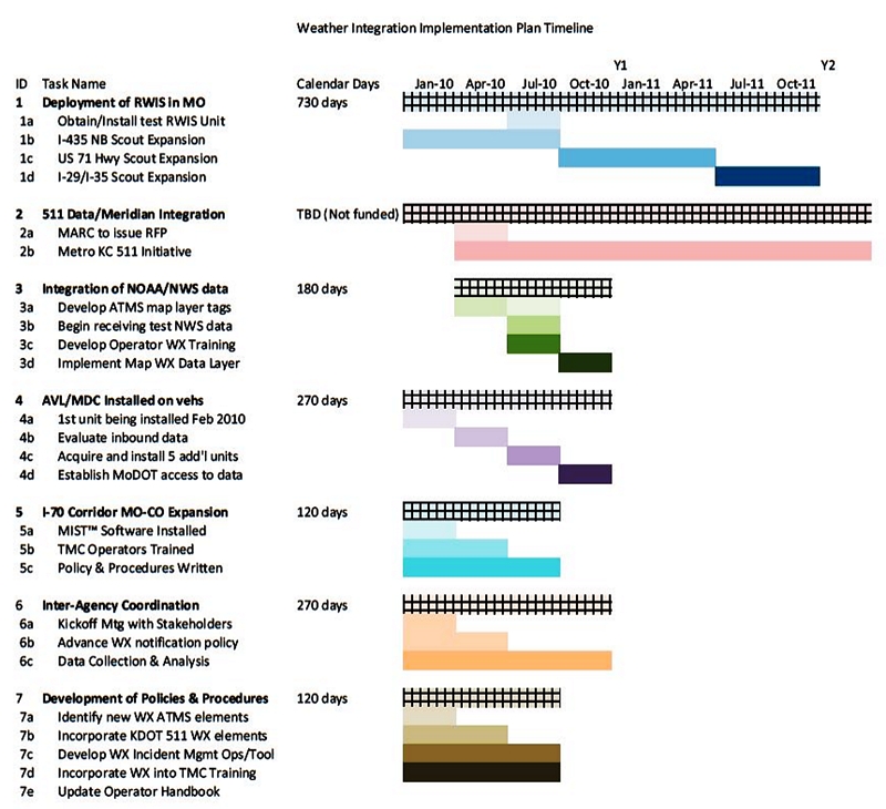
Illustration Credit: KC Scout
8.3.1 RWIS Deployment
MoDOT has determined that the existing RWIS stations currently installed throughout the metropolitan KC area are in need of replacement due to their age and unreliability. These legacy units will be replaced in accordance with Maintenance schedules and budget approvals. Six (6) new RWIS devices are being installed by KC Scout in conjunction with three (3) pre-approved expansion plans according to the schedule shown in Figure 8.3.3.
The decision to include RWIS station installation in the construction contracts for KC Scout’s expansion efforts enabled the costs to be incurred within the preapproved capital contract budgets and not incurred as expenditures from Scout’s operating budget. Given the current recession climate for DOTs in general, this represents a shift from reactive expenditures to proactive planned spending since the power and cabinet installation are already included in each of the above route expansions. It is estimated that the added cost of including the above 6 RWIS within the construction contracts totals $55K with an estimated annual operating cost of $3,800 per unit which includes maintenance provided by the equipment vendor.
The units will deliver surface temperature, dew point, air temperature and pavement friction data. This data will be available to aid Maintenance and Motorist Assist in being proactive regarding treatment and monitoring during weather events, thus reducing patrol activity to obtain physical measurements and saving labor, equipment and recurring costs. Response time for treatment will be more timely and effective. It is KC Scout’s intent to incorporate the integration of RWIS XML output data as a layer within the TransSuite™ ATMS as early as August 2010.
Another benefit of having RWIS data will be the ability to analyze and compare accident reduction efforts associated with monitored areas versus segments without RWIS detection. The results will hopefully help to make the case for future RWIS deployments and ultimately save lives and damage to property.
RWIS Deployment in Kansas
KDOT maintains 42 RWIS sites statewide, eight with CCTV capability and a ninth combined unit planned for April or May. However, none of these current and planned sites are located along the KS I-70 corridor. The majority of KDOT sites are in rural areas of the state and are maintained and repaired by a maintenance employee dedicated to their upkeep. KDOT added CCTVs and DMS along the I-70 corridor in 2008-2009 and these will be monitored by Scout on an as-needed, backup basis to help support KDOT’s newly established virtual TMC in Wichita.
Additionally, the KTA (Kansas Turnpike Authority), maintains 53 RWIS sites along their 236 miles of toll road connecting Kansas City, Topeka and Wichita. Negotiations with KTA and KDOT ITS personnel are ongoing in pursuit of cooperative agreements concerning access to CCTVs and data. KTA uses HAR (Highway Advisory Radio) instead of DMS to advise motorists of inclement weather conditions. It also promotes the use of 511 statewide for weather information updates. KC Scout’s proactive response to adverse weather conditions in Kansas will enable motorists traveling from Missouri across into Kansas and beyond to the Colorado border with road closure information well in advance to aid travelers in their decision making.
8.3.2 Meridian Data Integration from 511 Systems
KDOT utilizes a Meridian solution to provide 511 Traveler Information which includes Clarus data among 36 varied sources of 24x7 available information elements that are road and segment specific. Efforts have begun to identify those data elements that can be utilized by Scout’s ATMS system and its website. The next Scout TransSuite™ ATMS software upgrade scheduled for April 2010 includes tags for incorporating KDOT weather data into the mapping program.
Barb Blue, KDOT’s ITS 511 Program Manager and member of Scout’s Weather Integration project team has been assigned project management responsibility for a planned Metro KC 511 Initiative to be administered by MARC (Mid-America Regional Council). An RFP was being developed for release in the spring of 2010, but due to a lack of dedicated funding, this project is presently on hold.
8.3.3 Integration of NOAA Datasets
The participation and response of team members from NOAA’s NWS Pleasant Hill Reporting Station has been integral to the success of this project from a planning perspective. On November 3, 2009 team members were given a tour of the weather station by Andy Bailey, Warning Coordination Meteorologist. Numerous follow up discussions have taken place since then. KC Scout was honored to host the year-end meeting of the Kansas City Chapter of the American Meteorological Society on December 16, 2009. Over 30 weather professionals toured the Scout TMC, many visiting Scout for the first time. Their understanding of the role of the TMC in providing information to the motoring public was greatly enhanced and further solidified our existing relationship with forecasters from our local media outlets. The TransSuite™ ATMS software upgrade scheduled for April 2010 has been designed to include geo-coded shapefiles (.shp) containing lat/long coordinates and data attributes from the NWS for inclusion as a map layer. Efforts are ongoing to identify how these new weather elements will be communicated via website, MyKCScout Alerts, and group list notification. Scout includes Alerts from the NWS in its MyKCScout Customized Alerts application, but due to the length and frequency of messages received from the NWS during an event, most subscribers quickly opted out of this text-messaging option.
It is envisioned that predefined adverse weather thresholds can be identified and linked to specific weather messages. Once reached, the geographical reference would be displayed as a layer on the ATMS mapping application and trigger the creation of a weather event and its associated messaging content and extent. In this way, weather will be treated as an “incident” just like any other traffic-affecting activity within the Scout system, and along the I-70 corridor from St. Louis to Colorado.
MoDOT currently subscribes statewide to weather service data for state internal use only, provided by WeatherorNot™ out of Shawnee, KS. However, KC Scout is not permitted to pass their forecast information through to our Website at the present time. Integration with the NWS will provide timely and targeted information that motorists can use and access readily whether on the road or planning their travel.
8.3.4 AVL/MDC Equipment Installation on Motorist Assist/Emergency Response Vehicles
KC Scout utilizes Interfleet™ to monitor the location and operating status of our Motorist Assist/Emergency Response fleet vehicles. This enables us to dispatch units more effectively and monitor their safety while on response calls. As a pilot project, KC Scout is deploying one (1) MDC (Mobile Data Computer) unit purchased at a cost of $2,500 with a $40 monthly recurring communications charge. This unit is scheduled for installation during March 2010 on one of the Motorist Assist Supervisor vehicles, which is in the field patrolling from 6 am until 8 pm. The unit will gather road condition data similar to RWIS and display these elements on the current Interfleet™ software interface at all TMC operator consoles. Based on an evaluation of the accuracy and integrity of the data received, Scout intends to purchase additional units for 2 vehicles per shift and 1 Emergency Response vehicle for overnight and weekend patrols. Funding for these units will become available after July 1, 2010 and is included in Scout’s Fiscal Year 2010-2011 budget. Purchase decisions will be made accordingly once funding is approved.
8.3.5 I-70 Corridor Management (St. Louis to Colorado Border)
8.3.5.1 MODOT I-70 Corridor Activity
KC Scout began messaging along the I-70 corridor between Kansas City and St. Louis beginning in 2007. In the event of an incident, MoDOT maintenance personnel or MSHP (MO State Highway Patrol) contacts Scout with all pertinent lane closure information and TMC operators activate appropriate DMS boards for the incident utilizing software from LedStar™. In addition, an email is generated to a group list of I-70 vested parties advising them of the incident. This email is updated whenever the conditions change or the incident clears. In 2009, six (6) DMS boards along the I-29 and I-35 corridors, north of the metro KC area were added to this process.
In late 2009, MoDOT began deploying CCTVs in close proximity to the 20 existing corridor DMS (10 in each direction). Access to the cameras will initially be view-only by TMC operators utilizing OmniCast™ technology. District employees will manage CCTV activity for their respective areas. Having CCTV view capability will assist TMC staff in assuring that incident information stays current and that no boards remain active after the clearance of an event. The ability to view actual road conditions along the corridor in conjunction with integrated weather data will assist Scout in monitoring changing weather patterns and responding proactively with appropriate messaging and advisory communications.
8.3.5.2 KDOT I-70 Corridor Activity
In January 2010, KC Scout staff completed training on KDOT’s Telvent MIST™ ATMS application in order to provide KDOT with after-hours activation of weather messaging on DMS boards along the KS I-70 corridor. Current operating system resource constraints exist between the Scout TransSuite™ ATMS and MIST™ application when running simultaneously on a workstation. Therefore, an Operator must log off of Scout’s ATMS while activating a KDOT message board. To help alleviate this incompatibility between software applications, Scout purchased a laptop dedicated to the KDOT application only.
At the present time, KDOT policy is to only post weather related information. The discussion to expand this to include incident/lane closure messaging is currently being addressed by KDOT’s ITS executive staff. A 7a-8p, 2-person staffed “virtual” TMC is being co-located in Wichita within the city’s E911 communications center. After normal business hours, the 911 center operators have been cross-trained on the MIST™ application, if needed. Scout will serve as a secondary source for activating message boards. Each KDOT District is responsible for maintaining its’ own hardware components (DMS & CCTVs). Consistency among districts with regard to messaging content is currently under review by KDOT management.
The success of weather messaging along the I-70 corridor in Kansas is dependent upon a uniform set of message guidelines which is presently lacking among the six Districts in the state. KC Scout’s six years of experience with incident messaging is aiding in this dialogue between the rural and urban districts. The added component of integrated weather information into Scout’s core ATMS operating system is something KDOT is monitoring closely, as reflected by their participation with the Project effort.
The I-70 Corridor has been studied by KDOT since early 2000 and various websites refer to active and planned projects.

Source: http://kdotarchitecture.ursprojects.com/
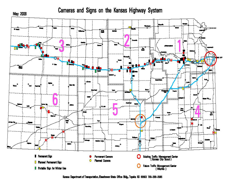
Illustration Credit: Kansas Department of Transportation May 2009
Figure 8.3.4 KDOT ITS Deployment Map
8.3.6 Inter-Agency Coordination
In an ongoing effort to build relationships with other ITS Heartland agencies, a kick-off meeting was held at the TMC on January 22, 2010, attended by representatives from Scout, KDOT, NDOR (Nebraska Department of Roads) and the cities of Omaha, NE and Topeka, KS. To help formalize this process, KC Scout hired a consultant to assist with the planned Regional CAD Integration effort scheduled to begin in April 2010. Additionally, this individual will help coordinate scheduled conference calls, arrange 2-3 hour informational seminars and participate with Scout in ITS Heartland activities and Scout’s own annual ITS Symposium, scheduled in conjunction with this year’s MoVITE Conference on April 29, 2010 in downtown KC.
Point-of-contact email distribution lists are being developed so that TMCs can easily notify key personnel in neighboring jurisdictions whenever weather events occur, enabling proactive advance messaging to aid travelers leaving one region for another. As an example, KC Scout currently uses a simple email generated form sent to predefined list members whenever lane closures occur along the I-70, I-35 and I-29 corridors in Missouri. This reduces the number of phone call attempts and assures that the information reaches appropriate personnel in a timely manner.
Figure 8.3.5 Sample Email Incident Notification Alert
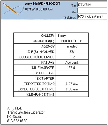
Illustration Credit: KC Scout
8.3.7 Development of Policies and Procedures
Implementing weather integration into standard TMC operations will involve the identification of new weather data elements integrated into the ATMS map layer. These various Common Alerting Protocol (CAP) tags have been incorporated into the April 2010 TransSuite™ software update. Discussion is underway to define weather event “thresholds” such as “wind gusts above 40 mph” which would trigger the ATMS map layer to display a polygonal reference of affected lat/long coordinates. Operators will then initiate a weather “event” with appropriate DMS messaging. Standard weather message sets are being developed and incorporated into the TransSuite™ Event Management module so that operators will only have to “accept” the proposed message to have it display correctly. Similarly, the ATMS will generate alert messages for the Scout Website and MyKCScout subscribers.
Efforts are underway to also incorporate available Clarus™ weather data XML elements as currently provided by KDOT’s Meridian 511™ system. The data transfer protocols are being reviewed by Scout’s software developers and likely will be included in the fall 2010 software update.
Operator Handbooks will need to be updated accordingly to reflect weather integration. Training modules within the Operator Certification Process will also need to be created to support end-user training.
8.4 Additional Impacts On Existing TMC Operations As a Result of Weather Integration Efforts
Staffing, support and training have been discussed within each strategy and are components of business-as-usual within the TMC. What is not so well understood are the communication costs and data storage ramifications of implementing new levels of weather information integration. If the data is available, Scout will be expected to report on it. Only by having true measurement criteria, can the success of any project be determined.
Where known, cost estimates have been included within the previous sections as pertains to each integration strategy/solution. Various initiatives are already underway with no cost impacts to Scout’s TMC budget. Our operators have become accustomed to taking on increasing levels of responsibility. It is Scout management’s task to see that training keeps up with the deployment of newer technology and system expansion. With implementation comes the added cost of supporting these new information platforms. Those cost estimates will need to be further investigated but are not seen as deterrents to moving forward with weather integration. The benefits far outweigh the costs.
9.0 OPERATIONS AND MAINTENANCE REQUIREMENTS
The operations and maintenance requirements of the planned weather integration activities defined in this document are expected to have minimal impact and will be addressed by existing activities and staff. The O&M requirements on the technological integration into Scout’s software will be handled by existing agreements with our software vendor and by Scout IT staff. The additional RWIS deployments planned will be a part of an existing network. Maintenance crews that currently service the existing RWIS will be tasked with adding these new devices to their existing list of stations.
10.0 ANTICIPATED CHALLENGES AND CONSTRAINTS OF INTEGRATION
The implementation tasks described in this document are currently underway. Momentum is building to continue finding ways to improve the delivery of services. Information technology is providing the means to continue growth of our ITS infrastructure. Funding has been appropriated to move these projects forward. The challenges and constraints faced by KC Scout as we move forward with implementation of this Weather Integration Plan include budgets, staffing, related schedule impacts, and technology integration.
Departments of Transportation are not immune to the effects of a recession economy. In November of 2009, MoDOT and KDOT both faced severe financial constraints as a result of the downturn. Organizations like KC Scout can struggle to balance shifting priorities, budget constraints, schedule delays, changes in leadership, and the need to juggle numerous initiatives to meet deadlines and avoid penalties. These conditions may place challenges on implementing the weather integration activities defined in this document. Additionally, KC Scout has only two shift supervisors responsible for 24/7 operations, and at times it becomes necessary to juggle project activity with floor supervision. Further, the Missouri statewide rural deployment of 69 CCTVs on major state highways will impact Scout by its having “after-hours support” capability due to our being one of two 24X7 TMCs in the entire state.
The constraints of any organizational integration effort are doubled in the case of KC Scout since our direction comes from not one, but two state departments of transportation. KDOT sustained the same types of funding shortfalls, and some ITS projects were put on “temporary hold” including the planned TMC in Wichita and DMS deployment on the I-70 corridor. Funding was cut for ITS expansion projects within KDOT as recently as March 5, 2010.
KC Scout may also encounter roadblocks having to do with technology issues. MoDOT’s IT department recently moved forward with NGD (Next Generation Desktop) deployment of Microsoft Windows 7 and issues continue to arise involving compatibility with older legacy systems. Technology integration challenges may be faced by our ATMS software developer/vendor to deliver the planned upgrades to accommodate weather data integration in the next software upgrade scheduled for April 2010.
11.0 APPENDIX – KC SCOUT WEATHER INTEGRATION PLAN

KC Scout Weather Integration Plan
Self-Evaluation Guide Report
11.1 APPENDIX A – SUMMARY REPORT OF WEATHER EXPERIENCED EVENTS
Summary report of weather events experienced by your TMC (Section 1 Report)
Weather Event |
Frequency |
Extent |
Impact |
|---|---|---|---|
Blizzard or White-out |
Seldom |
Regional |
Significant Impact |
High Winds |
Seldom |
Areawide |
Little Impact |
Temperature Extremes |
Occasional |
Regional |
Little Impact |
Tornadoes |
Occasional |
Local/Isolated Spots |
Moderate Impact |
Blowing Snow |
Regular |
Areawide |
Moderate Impact |
Bridge Frost, Road Frost |
Regular |
Regional |
Moderate Impact |
Drizzle and Light Rain |
Regular |
Regional |
Little Impact |
Flooding |
Regular |
Local/Isolated Spots |
Significant Impact |
Flurries and Light Snow |
Regular |
Areawide |
Moderate Impact |
Moderate to Heavy Rain |
Regular |
Areawide |
Moderate Impact |
Moderate to Heavy Snow |
Regular |
Local/Isolated Spots |
Significant Impact |
Severe Thunderstorms |
Regular |
Local/Isolated Spots |
Significant Impact |
Sleet, and Freezing Rain |
Regular |
Local/Isolated Spots |
Significant Impact |
Smoke, Mist, Fog, Smog or Haze |
Regular |
Areawide |
Little Impact |
11.2 APPENDIX B – SUMMARY REPORT OF IMPACTS DUE TO WEATHER EVENTS
Summary report of impacts due to your weather events (Section 2 Report)
Weather often impacts the activities of transportation system operators working to maintain safety and mobility. Making sense of weather information along with recognizing the benefits of its application beyond the simplest case is not a trivial task. As a generalization, TMC operators tend to be more responsive and take action based on their observations of traffic impacts rather than responding directly to weather information. It is important to understand the nature of weather impacts on capacity and speed reductions, impacts on safety (e.g., crash risk/frequency, incident management including Safety Service Patrols that are often dispatched from or coordinated with TMCs), and impacts on institutional coordination (i.e., need for communication between traffic managers and maintenance personnel, traffic managers and emergency management personnel, traffic managers and law enforcement personnel) to ensure that the self-evaluation and the integration solutions address the right concerns. The ability to estimate impacts could presumably lead to managing freeway systems and arterial signal systems using advisory, control and treatment strategies efficiently.
This report identifies the impacts of these weather events on your TMC’s traffic operations considering both impacts to users as well as operators.
Traffic impacts commonly associated with the weather events in your region.
Weather Event |
Increased |
Increased |
Reduced |
Traffic Management |
Disruption of CVO or |
Road Closures |
|---|---|---|---|---|---|---|
Drizzle and Light Rain |
||||||
Moderate to Heavy Rain |
||||||
Severe Thunderstorms |
||||||
Flooding |
||||||
Flurries and Light Snow |
||||||
Moderate to Heavy Snow |
||||||
Blizzard or White-out |
||||||
Sleet, and Freezing Rain |
||||||
High Winds |
||||||
Blowing Snow |
||||||
Smoke, Mist, Fog, Smog or Haze |
||||||
Tornadoes |
||||||
Temperature Extremes |
||||||
Bridge Frost, Road Frost |
Roadway impacts commonly associated with the weather events in the region
Weather Event |
Slick Roads |
Road Obstruction |
Structural Deterioration |
Present of Debris |
Low Visibility |
Others (Please Specify) |
|---|---|---|---|---|---|---|
Drizzle and Light Rain |
||||||
Moderate to Heavy Rain |
||||||
Severe Thunderstorms |
||||||
Flooding |
||||||
Flurries and Light Snow |
||||||
Moderate to Heavy Snow |
||||||
Blizzard or White-out |
||||||
Sleet, and Freezing Rain |
||||||
High Winds |
||||||
Blowing Snow |
||||||
Smoke, Mist, Fog, Smog or Haze |
||||||
Tornadoes |
||||||
Temperature Extremes |
||||||
Bridge Frost, Road Frost |
Specific impacts of weather events in your region on TMC operations
LEGEND
4 - Significant impact, 3 - Moderate impact, 2 - Little impact, 1 - No impact
Weather Event |
Increased use of equipment and labor |
Increased in-house labor |
Increased contractor labor |
Loss of |
Changes in traffic control operations |
Others |
|---|---|---|---|---|---|---|
Drizzle and Light Rain |
2 | 1 | 1 | 1 | 1 | |
Moderate to Heavy Rain |
3 | 1 | 1 | 2 | 1 | |
Severe Thunderstorms |
3 | 2 | 2 | 3 | 1 | |
Flooding |
3 | 3 | 2 | 2 | 3 | |
Flurries and Light Snow |
2 | 1 | 1 | 1 | 1 | |
Moderate to Heavy Snow |
4 | 3 | 2 | 2 | 3 | |
Blizzard or White-out |
4 | 3 | 2 | 2 | 4 | |
Sleet, and Freezing Rain |
4 | 3 | 2 | 3 | 3 | |
High Winds |
2 | 2 | 1 | 2 | 1 | |
Blowing Snow |
3 | 2 | 1 | 1 | 2 | |
Smoke, Mist, Fog, Smog or Haze |
3 | 3 | 1 | 1 | 1 | |
Tornadoes |
2 | 1 | 1 | 2 | 2 | |
Temperature Extremes |
1 | 1 | 1 | 2 | 1 | |
Bridge Frost, Road Frost |
2 | 1 | 1 | 1 | 2 |
11.3 APPENDIX C – SUMMARY REPORT OF CURRENT LEVEL OF WEATHER INTEGRATION
Summary report on your TMC’s current level of weather integration (Section 3 Report)
| Item of Integration: I1 Use of Internal Weather Information Resources | |||||
|---|---|---|---|---|---|
None |
Camera imagery |
Radar, satellite, ASOS and AWOS data, and general zone-type forcast information |
Level 2 data plus data from RWIS and related networks |
Level 3 data plus data from AVL/MDC sources and internal radio communications |
Level 4 data with addition of analyzed fields and trandformed data parameters (frost index, wind chill, est. snow, ice, water depth) |
| Item of Integration: I2 Use of External Weather Information Resources | |||||
None |
General weather information, forecsts, and interpretation provided through media as irregular service (radio and TV weather) |
Internet provided, public access general forecasts, weather radar or satellite image or weather-specific broadcast channel |
Field observers or probes providing scheduled weather/driving condition information from entire route system |
Contractor provided surface transportation weather forecasts targeted at the operational needs of the TMC agencies |
Direct connection between private weather information service providers and trffic management software |
| Item of Integration: I3 Availability of Weather Information | |||||
None |
Cable channel or subscription weather information vendor providing general weather information |
Internet provided weather radar or satellite image on video wall or computer screen |
Field observers or ESS network providing scheduled road or driving condition reports |
Vendor provided daily surface transportation weather forecasts and observed weather conditions including level 3 |
Meteorologist, located within TMC, forecasting and interpreting weather |
| Item of Integration: I4 Frequency of Weather Forecasts | |||||
None |
Receive information of weather forecasts on a request basis |
Receive weather forecast once daily |
Receive periodic forecasts several times a day |
Receive hourly updates of weather forecasts several times a day |
Receive continuous updates of weather forecasts in real-time |
| Item of Integration: I5 Frequency of Weather/Road Weather | |||||
None |
Receive information of weather conditions on a request basis |
Receive weather observations once hourly |
Level 2 plus receive weather/road weather observations when predefined thresholds have been exceeded |
Receive weather/road weather observations every ten minutes and when predefined thresholds have been exceeded |
Receive weather/road weather observations coninuously with data above predefined thresholds highlighted |
| Item of Integration: I6 Weather Information Coordination | |||||
None |
Intr-TMC committee tasked with weather information coordination |
Identified TMC or maintenance staff member tasked with coordinating weather information at TMC or virtually linked to the TMC |
Dedicated weather operations supervisor |
Meteorology staff located within the TMC forecasting and interpreting weather information |
Co-location of the EOC/OEM |
| Item of Integration: I7 Extent of Coverage | |||||
None |
Sparse Set of Isolated Locations |
Network of Scattered Locations |
Corridor-level |
Multiple-corridor/sub-regional |
Regional/Statewide |
| Item of Integration: I8 Interaction with Meteorologists | |||||
None |
Focus group or informal gatherings of local professinals from the transportation management and weather communities |
Develop check list of routine weather awareness activities |
Periodic staff meetng that includes a meteorologist to discuss weather information needs and responses |
With a meteorologis present conduct post-event debriefing/regular assessment to fine-tune responses |
Daily personal briefings and integrated interruptions by meteorology staff within the TMC |
| Item of Integration: I9 Alert Notification | |||||
None |
Monitor media outlet, Internet page, or data stream for critical events |
Telephone call list |
Manual email/paging system |
TMC road weather system (RWIS/ALERT/FEWS) generated specific notifications (Email or page) |
Automatic notification through Center-to-Center communications |
| Item of Integration: II10 Decision Support | |||||
None |
Ad-hoc implementation of weather management strategies |
Use quick-reference flip cards on operator's workstation to implement predefined response |
Response scenarios through software supply potential solutions with projected outcomes based on weather/traffic modeling |
Automated condition recognition and advisory or control strategy presented to operator for acceptance into ATMS |
Automated condition recognition and advisory or control strategy implemented without operator intervention |
| Item of Integration: II11 Weather/Road Weather Data Acquisition | |||||
None |
Media Reports |
Internet and/or Satellite Data Sources |
Across agency intranet and dedicated phone acquisition |
Dedicated communications link to state, federal, private data sources |
Dedicated communications link to state, federal, private data sources including vehicle-derived weather data |
11.4 APPENDIX D – SUMMARY REPORT OF OPERATIONAL NEEDS
Summary report on your TMC operational needs that could be addressed by better weather integration (Section 4 Report)
Rating Legend: 3 – High, 2 – Medium, 1 - Low, 0 – No Need
Need Area-Rating |
Need Statement |
|---|---|
3-High |
Disseminate weather information to a larger set of stakeholders and users in the region (including transit and other modes) |
3-High |
Provide better en-route information on weather conditions to aid travelers in their decision-making |
2-Medium |
Improve targeting of weather messages (site-specific; user group specific) to more effectively convey road weather information. |
2-Medium |
Improve message content (for DMS, 511, HAR, Web sites, etc.) |
1-Low |
Provide better pre-trip weather condition information to aid travelers in their decision-making |
Need Area-Rating |
Need Statement |
|---|---|
3-High |
Develop and implement clear, written policies and procedures for handling weather events. |
2-Medium |
More opportunities and mechanisms for communications and exchange with others in the weather community and those with experience dealing with weather events. |
2-Medium |
More coordinated responses and information with adjacent jurisdictions/regions |
2-Medium |
Improve coordination with local public safety and emergency agencies |
1-Low |
Improve coordination within the TMC |
Need Area-Rating |
Need Statement |
|---|---|
2-Medium |
Improve traffic signal timing during weather events to facilitate traffic movement |
1-Low |
Improve management of emergency routing and evacuation for large-scale weather events |
1-Low |
Improve traffic diversion and alternate routing capabilities |
0-No Need |
Improve safety at intersections during weather events |
Need Area-Rating |
Need Statement |
|---|---|
3-High |
Improve the timeliness of weather management response including deployment of ield personnel and equipment |
1-Low |
Reduce the time required to restore pre-event level of service operations after a weather event |
0-No Need |
Reduce costs of roadway treatment options |
0-No Need |
Need to assist maintenance in determining the optimal treatment materials, application rates, and timing of treatments |
Need Area-Rating |
Need Statement |
|---|---|
3-High |
Assistance in interpreting weather information and how best to adjust operations in light of that information |
3-High |
Better real-time information on road conditions during weather events |
2-Medium |
Better prediction of impact of weather events including assessment of reductions in capacity |
2-Medium |
Better short-term forecasts of arrival time, duration, and intensity of specific weather events at specific locations |
1-Low |
Improve the coverage and granularity of weather information in the region |
11.5 APPENDIX E – CURRENT INTEGRATION STRATEGIES REPORT
Current integration strategies – Report that describes in more detail integration strategies for your TMC’s current level of weather integration (Section Report 5a)
Item of Integration: Use of Internal Weather Information Resources
Level:
2
Title:
Radar, satellite, ASOS and AWOS data, and general zone-type forecast information
Definition:
This level of integration may provide TMC’s with data on a local, regional, and/or statewide scale(s). Radar and satellite provide past and present data on possible precipitation over a designated region while ASOS and AWOS provide observations of conditions at precise, pre-determined locations. General zone-type forecast information gives TMC’s a broad picture of possible weather events that may affect their region. These types of forecasts provide information on a region scale, including expected:
- Maximum and minimum temperature
- Average wind speed and direction
- Cloud cover
- Chance of precipitation within the region
- Range of timing associated with precipitation
Complexity - Relative scale (High, Medium or Low) across the levels indicating the degree of difficulty in implementing this level:
Low
Cost- Relative scale (High, Medium or Low) across the levels indicating the cost in implementing this level:
Low
Requirements across the dimensions for strategy:
Operational
- Use radar, satellite, ASOS/AWOS, NWS zone forecasts, and media provided local forecast data to support TMC operations
- Conduct staff training sessions on the characteristics of these weather information resources and their use in operations
Physical
- Establish the communications link to the weather resource data
- Procure any necessary equipment to process or display the weather data
Technical
- Determine the source of the weather data
- Determine how the data will be processed internally
- Determine whether the data will be displayed separately from camera imagery or via the same display mechanism
- Develop or procure the necessary software to manage the data stream and permit operators to request and display the desired images or image loops
Procedural
- Define which ASOS/AWOS stations and zones are needed for operations
- Establish procedures to restore data feed and processing if a break in acquisition occurs
- Establish public relations material on use of weather information
Institutional
- Determine how management may acquire access to the weather data
- Establish rules of practice regarding use of the weather data
- Map out methods for integration of the weather information into existing or planned traffic management programs
Item of Integration: Use of External Weather Information Resources
Level:
2
Title:
Internet provided, public access general forecasts, weather radar or satellite image or weather-specific broadcast channel
Definition:
Weather information at this level of integration provides weather data at regular intervals with information given in non-location-specific formats. Weather information at this level may be supplied to the TMC via the Internet through a private weather provider or through public forecasts. Forecasts provided are not tailored to the needs of the TMC but rather give a broad overview of conditions/forecasts within a given region.
Complexity - Relative scale (High, Medium or Low) across the levels indicating the degree of difficulty in implementing this level:
Low
Cost- Relative scale (High, Medium or Low) across the levels indicating the cost in implementing this level:
Low
Requirements across the dimensions for strategy:
Operational
- Use radar, satellite, ASOS/AWOS, NWS zone forecasts, and media provided local forecast data to support TMC operations
- Conduct staff training sessions on the characteristics of these weather information resources and their use in operations
Physical
- Establish the communications link to the weather resource data
- Procure any necessary equipment to process or display the weather data
Technical
- Determine the source of the weather data
- Determine how the data will be processed internally
- Determine how the information will be displayed in the TMC operations center
- Develop or procure the necessary software to manage the data stream and permit operators to request and display the desired images or image loops
Procedural
- Define which ASOS/AWOS stations and zones are needed for operations
- Establish procedures to restore data feed and processing if a break in acquisition occurs
- Establish public relations material on use of weather information in TMC operations
Institutional
- Determine how management may acquire access to the weather data
- Establish rules of practice regarding use of the weather data
- Map out methods for integration of the weather information into existing or planned traffic management programs
Item of Integration: Availablility of Weather Information
Level:
2
Title:
Internet provided weather radar or satellite images on video wall or computer screen
Definition:
Weather radar and/or satellite imagery provides real-time weather information to TMCs through images displayed on the video wall within the operations center. Radar and satellite are continuously updated via the Internet which results in real-time information. None of this information is interpreted by the Internet; therefore weather information may be confusing or non-beneficial for the TMC’s operations.
Complexity - Relative scale (High, Medium or Low) across the levels indicating the degree of difficulty in implementing this level
Low
Cost- Relative scale (High, Medium or Low) across the levels indicating the cost in implementing this level
Low
Requirements across the dimensions for strategy:
Operational
- Weather information is viewed by TMC staff on facility monitors
Physical
- Set-up video wall to display radar and/or satellite
Technical
Minimal
Procedural
Minimal
Institutional
Minimal
Item of Integration: Frequency of Weather Forecasts
Level:
4
Title:
Receive hourly resolution weather forecasts several times a day
Definition:
This strategy extends the features of a daily detailed (hourly) weather forecast by permitting a refinement of the forecasted weather conditions several times a day with new hourly resolution forecasts. This permits the weather forecasts to respond to new weather observations and additional weather model projections. The value of these forecasts is in the detail afforded by the hourly resolution along with the updates during the day. TMC operations would use these forecasts to more frequently adjust to time critical variations in forecasted weather conditions.
Complexity - Relative scale (High, Medium or Low) across the levels indicating the degree of difficulty in implementing this level
Low
Cost- Relative scale (High, Medium or Low) across the levels indicating the cost in implementing this level
Medium
Requirements across the dimensions for strategy:
Operational
- Establish a method of including periodic forecast information within TMC operations that accounts for the updated information
Physical
- Need an agency distribution system to provide notifications of forecast arrival and updates
Technical
- Develop standard operating procedures for requesting a forecast
Procedural
- Establish methods for reporting on the usefulness of weather forecasts at the frequency being received
Institutional
- Need to identify TMC staff qualified to determine the frequency of weather forecasts needed
Item of Integration: Frequency of Weather/Road Weather Observations
Level:
3
Title:
Receive weather/road weather observations when predefined thresholds have been exceeded
Definition:
This strategy combines the standard hourly flow of weather observations to include road weather observations. Further, using thresholds predefined by TMC personnel to identify critical operational situations, the weather and road weather observations are provided when these thresholds are exceeded. This would enable TMC staff to quickly identify locations and weather situations that are most crucial to their decision making efforts.
Complexity - Relative scale (High, Medium or Low) across the levels indicating the degree of difficulty in implementing this level:
Low
Cost - Relative scale (High, Medium or Low) across the levels indicating the cost in implementing this level:
Medium
Requirements across the dimensions for strategy:
Operational
- Establish a method of including weather and road weather observations within TMC operations that accounts for the updated information
- Define performance measures that assess the utilization of weather and road weather observations relative to the frequency of acquisition
Physical
- Need an agency distribution system to provide notifications of weather and road weather observations that exceed threshold values
Technical
- Define the frequency of weather and road weather observations needed and the appropriate delivery times
Procedural
- Establish methods for reporting on the usefulness of weather forecasts at the frequency being received
Institutional
- Define the administrative process to manage the flow of weather and road weather observations within the TMC infrastructure
- Define the process to address quality issues associated with observation data
Item of Integration: Alert Notification
Level:
1
Title:
Monitor media outlet, Internet page, or data stream for critical events
Definition:
In this strategy, TMC operators would simply monitor media outlets, Internet pages and other weather-related data streams to monitor when weather conditions at critical locations might justify a response. Under this strategy, weather information would be used solely by the TMC. The TMC might use this information to place messages on dynamic message signs, or highway advisory radio, but there would be no communications to external response providers (such as police or maintenance crews).
Complexity - Relative scale (High, Medium or Low) across the levels indicating the degree of difficulty in implementing this level:
Low
Cost- Relative scale (High, Medium or Low) across the levels indicating the cost in implementing this level:
Low
Requirements across the dimensions for strategy:
Operational
Minimal
Physical
- Need access to external information source(s) (i.e. radio station, Internet, weather service provider)
Technical
Minimal
Procedural
- Develop standard operating procedures for monitoring of weather information by TMC operator
Institutional
Minimal
Item of Integration: Decision Support
Level:
1
Title:
Ad-hoc implementation of weather management strategies
Definition:
Under this strategy, operators in the TMC manage the impacts of weather on traffic operations on an ad-hoc basis. Using detection and surveillance technologies, operators observe and monitor the effects and impacts that particular weather events have on traffic operations and adjust the advisory, control, and treatments responses based on these observations. TMC operations may have general knowledge about what types of responses to implement (based upon previous experience) but do not necessarily have any formalized, pre-planned responses to manage traffic during developing weather.
Complexity - Relative scale (High, Medium or Low) across the levels indicating the degree of difficulty in implementing this level:
Low
Cost - Relative scale (High, Medium or Low) across the levels indicating the cost in implementing this level:
Low
Requirements across the dimensions for strategy:
Operational
- Establish “Weather triggers” as a baseline for TMC operators to implement appropriate ad-hoc responses.
Physical
- Need access to readily available weather information source(s) (i.e. cameras, radio station, Internet, weather service provider, filed sensors, etc.
Technical
Minimal
Procedural
- Ensure that TMC operators reacting to weather events on an ad-hoc basis do not overstep their authority or TMC procedures in implementing a specific response.
- Develop a set of standard operating procedures for fine-tuning weather responses, including the recovery mechanism from an implemented ad-hoc response.
Institutional
Minimal
Item of Integration: Weather/Road Weather Data Acquisition
Level:
2
Title:
Internet and/or satellite data sources.
Definition:
In this strategy, TMC operators would acquire road-weather information from internet and/or satellite data sources. These sources can be from public or private weather information providers and allow the operator to continuously monitor developing conditions. Using satellite and Internet sources, operators can obtain predictions of when weather conditions, such as snow and heavy rainfall, might arrive at specific locations.
Complexity - Relative scale (High, Medium or Low) across the levels indicating the degree of difficulty in implementing this level:
Low
Cost - Relative scale (High, Medium or Low) across the levels indicating the cost in implementing this level:
Low
Requirements across the dimensions for strategy:
Operational
- Monitor weather information from additional sources, such as Internet or satellite data feeds.
- Access weather forecasts / predictions on movement of weather systems.
- Enable forecast / prediction information to be passed on to other TMC subsystems.
Physical
- Secure ability to access Internet or satellite communications feed capability to access weather information.
- Install terminal in TMC for displaying weather information
- Integrate internet weather feeds into TMC displays
Technical
Minimal
Procedural
- Obtain access to additional information sources such as public Internet feeds, private Internet streams, or satellite information.
- Set policies to allow operators to actively monitor weather information from these additional sources.
Institutional
- Provide funding to continue access to additional weather information sources.
11.6 APPENDIX F – INTEGRATION STRATEGIES TO MEET OPERATIONAL NEED
Report that describes integration strategies to meet the following TMC’s selected operational needs. This is your integration target (Section 5b Report)
Item of Integration: Use of Internal Weather Information Resources
Level:
3
Title:
Level 2 data plus data from RWIS and related networks
Definition:
TMC’s utilize all data sets within level 2 integration but also incorporate data from RWIS environmental sensor stations (ESS) and other weather networks that may be available for a given location. ESS provides TMC’s with weather directly adjacent to the road allowing for a better understanding of weather conditions affecting the road surface and ultimately traffic. The ESS observations can include, but are typically limited to:
- Air temperature
- Relative humidity/dew point temperature
- Wind speed and direction
- Pavement surface temperature
- Pavement surface condition
- Chemical concentration or freeze point temperature
Complexity - Relative scale (High, Medium or Low) across the levels indicating the degree of difficulty in implementing this level:
Medium
Cost - Relative scale (High, Medium or Low) across the levels indicating the cost of implementing this level:
Medium
Requirements across the dimensions for strategy:
Operational
- Use RWIS and related data within TMC operations
- Conduct staff training sessions on the features of RWIS data and how to interpret their impact on traffic flow
Physical
- Establish a communications link to a source of the RWIS data
Technical
- Determine the source of the RWIS and related data
- Determine how the data will be processed internally
- Determine whether the data will be displayed separately from camera imagery or via the same display mechanism
- Develop or procure the necessary software to manage the data stream and permit operators to request and display the data in the desired format
Procedural
- Define which RWIS stations or other resources are necessary to support operations
- Establish procedures to restore RWIS data feed and processing if a break in acquisition occurs
- Establish public relations material on use of RWIS information
Institutional
- Determine how management may acquire access to the RWIS data
- Establish rules of practice regarding use of RWIS data
- Map out methods for integration of RWIS data into existing or planned traffic management programs
Item of Integration: Use of External Weather Information Sources
Level:
4
Title:
Contractor provided surface transportation weather forecasts targeted at the operational needs of the TMC agencies
Definition:
This level of integration provides corridor level forecasting tailored to the needs of a TMC in an operational setting. The tailored forecasts are updated several times daily allowing TMCs to be aware of changing weather conditions that could affect traffic. TMCs are able to interact with the weather provider to request weather information for specific situations. This type of communications also permits the TMC representative to share guidance regarding how weather impacts TMC operations and how the weather provider can better support those needs. The forecasts received from the weather services provider will be much more detailed in nature than the information at the level 2 integration. This detail includes hour by hour forecasts of:
- Road conditions
- Pavement temperature
- Deck temperature
- Precipitation type
- Precipitation rate
- Precipitation start/end time
- General atmospheric parameters
Complexity - Relative scale (High, Medium or Low) across the levels indicating the degree of difficulty in implementing this level:
Medium
Cost - Relative scale (High, Medium or Low) across the levels indicating the cost of implementing this level:
High
Requirements across the dimensions for strategy:
Operational
- Use contractor-provided road weather information to support TMC operations
- Conduct staff training sessions on the characteristics of the contractor service elements and how to utilize these resources in operations
Physical
- Establish a communications link to a source of the post-processed weather data
Technical
- Integrate analysis products into the infrastructure developed for the previous levels of integration
Procedural
- Define which products need to be accessible in TMC
- Establish procedures to restore access to data if a break in acquisition occurs
- Establish public relations material on use of all levels of service and its benefit to
- TMC operations
Institutional
- Determine how management may acquire access to the entire suite of weather support information
- Establish rules of practice regarding use of the weather support data
- Map out methods for integration of the various weather resources into existing or planned traffic management programs
Item of Integration: Availablility of Weather Information
Level:
4
Title:
Vendor provided daily surface transportation weather forecasts and observed weather conditions including level 3
Definition:
The availability of data is only limited to the number of weather observations and frequency of forecast updates. A meteorologist within the TMC will provide data as near real-time as possible to aid in traffic operations. The interpretation of forecast and observations by a trained meteorologist also allows for more information to be utilized by TMCs because weather information can be quickly relayed to traffic managers in a form they can understand.
Complexity - Relative scale (High, Medium or Low) across the levels indicating the degree of difficulty in implementing this level:
Medium
Cost - Relative scale (High, Medium or Low) across the levels indicating the cost of implementing this level:
High
Requirements across the dimensions for strategy:
Operational
- Incorporate weather forecasts within TMC’s
Physical
- Set-up video wall to display radar and/or satellite
Technical
Minimal
Procedural
- Provision of data in a tabulation of weather/driving conditions
Institutional
Minimal
Item of Integration: Frequency of Weather Forecasts
Level:
4
Title:
Receive hourly resolution weather forecasts several times a day
Definition:
This strategy extends the features of a daily detailed (hourly) weather forecast by permitting a refinement of the forecasted weather conditions several times a day with new hourly resolution forecasts. This permits the weather forecasts to respond to new weather observations and additional weather model projections. The value of these forecasts is in the detail afforded by the hourly resolution along with the updates during the day. TMC operations would use these forecasts to more frequently adjust to time critical variations in forecasted weather conditions.
Complexity - Relative scale (High, Medium or Low) across the levels indicating the degree of difficulty in implementing this level:
Low
Cost - Relative scale (High, Medium or Low) across the levels indicating the cost of implementing this level:
Medium
Requirements across the dimensions for strategy:
Operational
- Establish a method of including periodic forecast information within TMC operations that accounts for the updated information
Physical
- Need an agency distribution system to provide notifications of forecast arrival and updates
Technical
- Develop standard operating procedures for requesting a forecast
Procedural
- Establish methods for reporting on the usefulness of weather forecasts at the frequency being received
Institutional
- Need to identify TMC staff qualified to determine the frequency of weather forecasts needed
Item of Integration: Frequency of Weather/Road Weather Observations
Level:
3
Title:
Receive weather/road weather observations when predefined thresholds have been exceeded
Definition:
This strategy combines the standard hourly flow of weather observations to include road weather observations. Further, using thresholds predefined by TMCpersonnel to identify critical operational situations, the weather and road weather observations are provided when these thresholds are exceeded. This would enable TMC staff to quickly identify locations and weather situations that are most crucial to their decision making efforts.
Complexity - Relative scale (High, Medium or Low) across the levels indicating the degree of difficulty in implementing this level:
Low
Cost - Relative scale (High, Medium or Low) across the levels indicating the cost of implementing this level:
Medium
Requirements across the dimensions for strategy:
Operational
- Establish a method of including weather and road weather observations within TMC operations that accounts for the updated information
- Define performance measures that assess the utilization of weather and road weather observations relative to the frequency of acquisition
Physical
- Need an agency distribution system to provide notifications of weather and road weather observations that exceed threshold values
Technical
- Define the frequency of weather and road weather observations needed and the appropriate delivery times
Procedural
- Establish methods for reporting on the usefulness of weather forecasts at the frequency being received
Institutional
- Define the administrative process to manage the flow of weather and road weather observations within the TMC infrastructure
- Define the process to address quality issues associated with observation data\
Item of Integration: Interaction with Meteorologists
Level:
3
Title:
Periodic staff meeting that includes a meteorologist to discuss weather information needs and responses
Definition:
This strategy provides the opportunity for the TMC without a meteorology staff to discuss weather information needs and responses. This discussion permits meteorologists to provide an orientation on weather and road weather solutions that exist that could be considered by the TMC staff to improve the utilization of weather and road weather in TMC decision making. The participation of a meteorologist would be on an infrequent basis but possible with increasing frequency as the TMC improves its weather integration efforts.
Complexity - Relative scale (High, Medium or Low) across the levels indicating the degree of difficulty in implementing this level:
Low
Cost - Relative scale (High, Medium or Low) across the levels indicating the cost of implementing this level:
Low
Requirements across the dimensions for strategy:
Operational
- Create a checklist of routine weather awareness activities
- Conduct periodic, scheduled meeting with staff to discuss weather information needs and responses with meteorologist participation
Physical
- Provide information message and notification system that facilitates rapid-responses between traffic management staff and meteorologists (in-house and external)
Technical
- Active listserve for exchange of coordination information
Procedural
- Develop protocols for addressing weather related traffic management issues with the weather community
- Develop a procedure for identifying weather-related events that require a post-event debriefing
Institutional
- TMC administrative support for staff (and administrators) to engage in dialog with the weather and surface transportation weather communities
Item of Integration: Alert Notification
Level:
4
Title:
TMC road weather system (RWIS / ALERT / FEWS) generated specific notifications (Email or page)-
Definition:
With this strategy, weather related alerts are sent to key response personnel on the call list automatically by road weather monitoring equipment. The systems would send the emails or pages directly to response personnel, replacing the need for the TMC operator to formulate a specific message. The TMC would need to develop the structure and format of the messages. Depending upon the type of road weather monitoring system installed within particular locations, responders can receive detailed weather information, including the following:
- Air temperature;
- Dew point or relative humidity;
- Precipitation occurrence, type and intensity;
- Precipitation accumulation and water level;
- Wind speed and direction;
- Visibility distance; and
- Pavement temperature, freezing point, condition, and chemical concentration
Complexity - Relative scale (High, Medium or Low) across the levels indicating the degree of difficulty in implementing this level
High
Cost - Relative scale (High, Medium or Low) across the levels indicating the cost of implementing this level:
High
Requirements across the dimensions for strategy:
Operational
- Automate weather alerts from RWIS or similar systems to TMC operators
- Define level of operator interaction (i.e approval required) for automated messaging of weather alerts
- Identify field devices and locations for data collection to support weather alert systems.
- Establish integrity of field data reporting systems and integration into TMC system software
Physical
- Establish infrastructure to support high-end systems, such as automatic notifications or C2C.
- Identify resource requirements for weather-related components
- Establish communication pathway between weather system components and TMC
- Determine hardware and software components necessary to accomplish integration of weather alerts and TMC software.
Technical
- Define data flows for weather information between field devices, software systems and TMC personnel.
- Establish display and update requirements for visual display of weather information or alerts within TMC operator station
- Establish communication protocols and message set standards for road weather information systems or similar devices
- Identify data elements, and storage mechanism for retaining information to generate performance measures
- Define interface requirements between systems sharing weather information.
- Establish a C2C infrastructure with identified agencies for sharing information, including weather alerts
Procedural
- Define TMC operator responsibilities within the weather alert notification system
Institutional
- Establish MOU / Inter-agency agreement to allow for joint monitoring of field devices by multiple agencies.
Item of Integration: Decision Support
Level:
3
Title:
Response scenarios are supplied through software that identifies potential solutions with projected outcomes based on weather/traffic modeling
Definition:
Under this strategy, a decision support tool would be developed that would allow the operator to generate potential advisory, control, and treatment responses based upon information about developing weather conditions. This decision support tool would incorporate criteria and triggers for different types of agency responses. The operator would be required to enter specific information about a developing weather event through an interface, and the system would then identify potential solutions and strategies based on a predefined set of “rules” or desired responses. Under this strategy, the operator would have the primary responsibility of both entering the appropriate weather information and implementing the appropriate advisory, control and treatment responses.
Complexity - Relative scale (High, Medium or Low) across the levels indicating the degree of difficulty in implementing this level:
Medium
Cost - Relative scale (High, Medium or Low) across the levels indicating the cost of implementing this level:
Medium
Requirements across the dimensions for strategy:
Operational
- Train TMC operators in implementation of pre-defined sequences, focusing on data sources, trigger points, and follow-up actions.
Physical
- Operator needs to view weather information sources and have available interface for data entry into decision support system.
Technical
- Develop system architecture to allow for weather data entry and analysis.
- Develop algorithm for generating suggested system response to weather events.
- Create visual interface into system data for TMC operator viewing / analysis.
- Establish support systems to ensure data quality and resolve conflicting
Procedural
- Develop a standard set of triggers which would cause an operator to initiate use of the decision support system.
- Develop standard rules and policies for implementing suggested response to weather triggers.
Institutional
- Develop inter-agency agreement to allow for the joint operation of traffic management infrastructure in the implementation of responses to weather events.
Item of Integration: Weather/Road Weather Data Acquisition
Level:
3
Title:
Across agency intranet and dedicated phone acquisition
Definition:
With this strategy, TMC operators would access their weather information not only from external sources, but agency owned and operated weather monitoring stations to acquire road-weather information. Weather monitoring devices would be installed at strategic locations and would allow the operator to access detailed weather information from specific locations. Depending upon the extent of coverage, information could be from scattered locations to region or area-wide. This level requires a more extensive communications network to bring back the weather information from the remote sensors to the TMC.
Complexity - Relative scale (High, Medium or Low) across the levels indicating the degree of difficulty in implementing this level:
Medium
Cost - Relative scale (High, Medium or Low) across the levels indicating the cost of implementing this level:
Medium
Requirements across the dimensions for strategy:
Operational
- Develop algorithms that monitor agency owned and operated weather information sources on a periodic basis.
Physical
- Procure and install system of agency owned and operated weather information sources.
- Integrate data feed with TMC software
- Provide an on-going communications capability to each information source.
Technical
- Establish or adopt communications protocols for transmitting weather information
- Establish or adopt standard message sets for weather information transmission
Procedural
- Set policies on the use of agency specific field information sources.
Institutional
- Provide funding to construct and maintain a field network of weather information sources.
11.7 APPENDIX G – INTEGRATION STRATEGIES TO MEET TARGET NEEDS
Report that describes integration strategies between where you are now and where you want to be. This describes steps to get to your target level of integration (Section 5c Report)
Item of Integration: Use of External Weather Information Sources
Level:
3
Title:
Field observation or probes providing scheduled weather / driving condition information from entire route system
Definition:
Road/weather information is reported to TMCs on scheduled intervals from field observations or instrumentation located within the right-of-way or roadway environment. The reports provide weather information that covers all routes within the TMC’s jurisdiction to aid in decision making processes. These data include:
- Road conditions
- Current weather conditions
- Past weather conditions
Complexity - Relative scale (High, Medium or Low) across the levels indicating the degree of difficulty in implementing this level
Medium
Cost - Relative scale (High, Medium or Low) across the levels indicating the cost of implementing this level:
Medium
Requirements across the dimensions for strategy:
Operational
- Use route specific (RWIS or MDC) data within TMC operations
- Conduct staff training sessions on the features of RWIS data and how to interpret their impact on traffic management.
Physical
- Establish a communications link to a source of the RWIS, MDC, or related field data
Technical
- Determine the source of the RWIS, MDC, and/or related data
- Determine how the data will be processed internally
- Develop or procure the necessary software to manage the data stream and permit operators to request and display the data in the desired format
Procedural
- Define which RWIS stations, MDC routes, or other resources are necessary to support operations
- Establish procedures to restore RWIS data feed and processing if a break in acquisition occurs
- Establish public relations material on use of RWIS and/or MDC information to support TMC operations
Institutional
- Determine how management may acquire access to the RWIS, MDC, or related data
- Establish rules of practice regarding use of this data
- Map out methods for integration of RWIS and MDC data into existing or planned traffic management programs
Item of Integration: Availablility of Weather Information
Level:
3
Title:
Field observers or ESS network providing scheduled road or driving condition reports
Definition:
Field observations or ESS networks provide data when weather information is needed. The availability of data is as needed or on a scheduled basis. The data can be collected from field observers on a schedule throughout the day or when weather may be affecting the route network. ESS can be scheduled to deliver data on a regular schedule or when thresholds are met by sensors and data are sent back to the TMCs.
Complexity - Relative scale (High, Medium or Low) across the levels indicating the degree of difficulty in implementing this level:
Medium
Cost - Relative scale (High, Medium or Low) across the levels indicating the cost of implementing this level:
Medium
Requirements across the dimensions for strategy:
Operational
- Establish locations for field observers to take observations
- Identify locations for ESS deployment
Physical
- Set-up video wall to display radar and/or satellite
Technical
Minimal
Procedural
- Provision of data in a tabulation of weather/driving conditions
Institutional
Minimal
Item of Integration: Weather Information Coordination
Level:
1
Title:
Intra-TMC committee tasked with weather information coordination
Definition:
This strategy provides a rudimentary process to incorporate weather information into the work environment within a TMC. Formation of a local committee provides a central structure to address weather information-related TMC activities and foster discussions to identify weather / road weather needs and methods to address these needs. This effort would most likely not include any external or internal meteorologist input.
Complexity - Relative scale (High, Medium or Low) across the levels indicating the degree of difficulty in implementing this level:
Low
Cost - Relative scale (High, Medium or Low) across the levels indicating the cost of implementing this level:
Low
Requirements across the dimensions for strategy:
Operational
- Establish lines of communications between the TMC and identified meteorologists
- Establish an email list of points-of-contact in the weather community
- Periodic staff meetings to discuss weather information needs
Physical
- Construct a database of contacts within the TMC and weather community who will be involved in interaction efforts
Technical
- Email communication between TMC staff and weather staff and advisors
Procedural
Minimal
Institutional
- Seek advice of weather consultant
Item of Integration: Weather Information Coordination
Level:
2
Title:
Identified TMC or maintenance staff member tasked with coordinating weather information at TMC or virtually linked to TMC
Definition:
This strategy would possible build upon an intra-TMC weather information coordination committee with a staff member assigned to coordinate weather information activities within the TMC. Or this could be a single staff member assigned to explore the same issues as the intra-TMC committee with an additional responsibility to perform ongoing efforts to better identify and address weather needs. This would be an individual either with a partial or full-time assignment to coordinate TMC weather information.
Complexity - Relative scale (High, Medium or Low) across the levels indicating the degree of difficulty in implementing this level:
Low
Cost - Relative scale (High, Medium or Low) across the levels indicating the cost of implementing this level:
Low
Requirements across the dimensions for strategy:
Operational
- Exchange weather issues of interest using a local TMC managed list-serve that includes both TMC staff and in-house and external weather staff
- Create a list of contacts with associated regions of weather expertise of importance to the TMC activities
- Provide routine orientation briefings of TMC staff on weather information availability and seek staff input on needs
- Local forums are held between TMC staff and local meteorological community
- Acquire staff training on weather/road weather information
Physical
- Provide communications interface that links weather supervisor with TMC supervisory personnel
- Provide communications support for in-house meteorology staff that provides effective exchanges of information between traffic management activities and meteorological analysis and forecast activities.
Technical
- Active listserve for exchange of coordination information
Procedural
- Develop a checklist of routine weather awareness activities to conduct with staff
Institutional
- Seek advice of weather consultant
Item of Integration: Extent of Coverage
Level:
1
Title:
Expand the extent of coverage of weather information to include a sparse set of isolated locations
Definition:
This strategy involves the collection of weather information from a set of isolated locations known to be impacted by severe weather. Examples of potential locations include low water crossings, bridges, mountain passes, etc. Generally weather information would be generated from agency-owned weather monitoring stations. These stations may be attached directly to specific traffic advisory, control, and treatment devices as stand-alone systems. Traffic advisory, control, and treatment responses would be designed to address weather-related impacts at those specific locations only.
Complexity - Relative scale (High, Medium or Low) across the levels indicating the degree of difficulty in implementing this level:
Low
Cost - Relative scale (High, Medium or Low) across the levels indicating the cost of implementing this level:
Low
Requirements across the dimensions for strategy:
Operational
- Establish “sensor triggers” to notify TMCs when specific sensors or stations have reported activity which indicates a weather condition.
- If triggered sensors at specific locations are not tied to an alert mechanism, TMC should issue a point specific alert.
Physical
- At minimum, need an accessible communications link to each information source.
Technical
- Determine the data reporting parameters and message components of each sensor type to insure information is captured accurately.
Procedural
- Develop standard operating procedures for monitoring of sensor network by TMC operator.
- Establish appropriate procedures for monitoring the health of sensor and communication systems.
Institutional
- •Obtain permission from appropriate agencies to place sensors at strategic locations.
- Identify funding sources for procuring systems, maintenance and operations, and regular and recurring training for field sensors systems.
Item of Integration: Extent of Coverage
Level:
2
Title:
Expand the extent of coverage to a network of sensors from scattered locations
Definition:
Instead of obtaining weather information from one or two isolated locations, weather information would be obtained from a network of strategically-located sites (5 to 10 locations) scattered throughout a region or urban region. The purpose of this network of sites would be to obtain a general overview of the weather conditions. The TMC operator would be able to use the information from the network to monitor the path and extent of changing weather conditions as well as to make strategic decisions for distributing resources and personnel. Information from these locations could also be used to provide advisory information via a web-site. Devices used to provide information would primarily be owned by the operating agency; however, agencies might consider integrating information from privately-owned devices, or devices owned by other operating agencies to complete the network or to fill in holes were information is missing.
Complexity - Relative scale (High, Medium or Low) across the levels indicating the degree of difficulty in implementing this level:
Medium
Cost - Relative scale (High, Medium or Low) across the levels indicating the cost of implementing this level:
Medium
Requirements across the dimensions for strategy:
Operational
- TMC to use weather information from sensor network to issue general advisory statements, using standard information dissemination capabilities such as DMS and web sites.
Physical
- Need to establish a standardized reporting or polling scheme for system sensors to transfer information to TMC on a routine basis.
- Need to establish a “back room” infrastructure to support the polling / reporting process to system sensors.
- Obtain access to external information source(s) (i.e. radio station, Internet, weather service provider) to expand system sources of information.
- Need to develop infrastructure capable of sharing sensor system alerts to appropriate agencies.
Technical
- Need to establish an analysis routine of system data which can monitor the path and extent of changing weather conditions based on sensor reports.]
Procedural
- Develop standard operating procedures for internal and external notification of sensor alerts.
- Develop standard procedures for keeping information dissemination methods updated (media, web, etc).
- Establish mechanisms for reporting on the effectiveness and timeliness of weather-related TMC alerts.
Institutional
- Develop data sharing agreement with appropriate agencies to allow access to sensors at additional strategic locations.
- Establish MOU / Inter-agency agreement to allow for joint monitoring of field devices by multiple agencies.
- Define the level of commitment and partnership between agencies for participating in systems for weather alert notifications.
Item of Integration: Extent of Coverage
Level:
3
Title:
Expand the extent of coverage to a network of sensors to provide corridor-level weather information
Definition:
In this strategy, an agency would expand the coverage of weather information devices that provides information about weather conditions from multiple locations in a specific corridor. The information would be obtained from specific locations in the corridor known to experience traffic problem caused by weather conditions. The corridor may consist of only a single facility or may be composed of multiple facilities serving similar trips (for example, a freeway and parallel arterials). The information would allow a TMC operator to make tactical decisions about what type of traffic management advisory, control, and treatments to implement in the corridor. Examples of the types of advisory, control, and treatment strategies that could be implemented with this level of deployment include coordinated signal timing plans to promote traffic movement on an emergency or evacuation route, deploying diversion routing around a flooded section of roadway, etc.). Weather information would need to be tightly coupled with traffic information from the corridor. This level of integration would be needed to support automated advisory, control and treatment responses
Complexity - Relative scale (High, Medium or Low) across the levels indicating the degree of difficulty in implementing this level:
Medium
Cost - Relative scale (High, Medium or Low) across the levels indicating the cost of implementing this level:
Medium
Requirements across the dimensions for strategy:
Operational
- TMC to use weather information from sensor network to issue corridor specific weather advisory statements.
- TMC system software should make automated suggestions for advisory messages.
- TMC system software should make suggestions on corridor specific operational control decisions which would alert and/or reduce impact of weather conditions.
Physical
- Need agency infrastructure capable of sending automated alerts to motorists
- Need agency infrastructure capable of operating with other agency infrastructure to affect control decisions (i.e. change of signal timing plans)
Technical
- Need to enhance analysis routines of system data to a more discreet corridor level to monitor and project changing weather conditions that would impact a specific travel corridor.
- Need to integrate sensor system data with traffic information to analyze developing condition from the standpoint of affected traffic.
Procedural
- Establish levels for automatic implementation of control system based on sensor and traffic data.
Institutional
- Liaison with other operating agencies / appropriate entities to establish an appropriate basis for sharing alert information and implementing strategic responses.
Item of Integration: Interaction with Meteorologists
Level:
1
Title:
Focus group or informal gatherings of local professionals from the transportation management and weather communities
Definition:
This strategy provides an opportunity for the transportation management and weather professionals to exchange respective professional views. The advantage of this effort is that it promotes familiarization of mutual opportunities in surface transportation weather and fosters a sense of shared values
Complexity - Relative scale (High, Medium or Low) across the levels indicating the degree of difficulty in implementing this level:
Low
Cost - Relative scale (High, Medium or Low) across the levels indicating the cost of implementing this level:
Low
Requirements across the dimensions for strategy:
Operational
- Attend local joint meetings between the weather and transportation communities
Physical
Minimal
Technical
- Email communication between TMC staff and weather staff and advisors
Procedural
- Establish methods to identify reliable and relevant weather community stakeholders of interest to the TMC
Institutional
Minimal
Item of Integration: Interaction with Meteorologists
Level:
2
Title:
Develop check list of routine weather awareness activities
Definition:
In this strategy the focus group or informal gatherings of local professionals in the transportation management and weather communities pursue activities to heighten the awareness of mutual interests, needs, and challenges in surface transportation weather. These activities results in the development of a structured check list of routine weather awareness efforts to address as a shared endeavor.
Complexity - Relative scale (High, Medium or Low) across the levels indicating the degree of difficulty in implementing this level:
Low
Cost - Relative scale (High, Medium or Low) across the levels indicating the cost of implementing this level:
Low
Requirements across the dimensions for strategy:
Operational
- Attend national/regional joint meetings between the weather and transportation communities
- Update checklist of routine weather awareness activities
- Host local joint meetings between the weather and transportation communities
Physical
- Provide communications interface that provides a remote link between consulting meteorologist and TMC personnel
- Provide communications support for in-house weather discussion that provides effective exchanges of information between traffic management activities and meteorological analysis and forecast activities.
- Provide communications support for in-house weather discussion that provides
Technical
- Active listserve for exchange of coordination information
Procedural
- Establish guidelines for communications between the weather community and TMC staff
- Develop a decision making process that identifies TMC staff who are required to interact with the weather/road weather community.
Institutional
Minimal
12.0 ADDENDUM – POTENTIAL ADVERSE WEATHER MESSAGING SETS
|
DMS Message Format (20 Characters) |
CMS Message Format (15 Characters) |
|---|---|
HIGH WIND ADVISORY |
HIGH WIND ADVISORY |
High Wind Advisory |
Wind Advisory |
MM 66 to 71 |
MM 66 to 71 |
Use Caution |
Use Caution |
WIND GUSTS REPORTED |
WIND GUSTS REPORTED |
Wind Gusts |
Wind Gusts |
Up to 60 MPH |
Up to 60 MPH |
Reduce Speed |
Reduce Speed |
THUNDERSTORM WATCH |
THUNDERSTORM WATCH |
Thunderstorm Watch |
Thunderstorm |
In Effect |
Watch In Effect |
Until 7:00 PM |
Until 7:00 PM |
THUNDERSTORM WARNING |
THUNDERSTORM WARNING |
Thunderstorm Warning |
Thunderstorm |
Issued At |
Warning Issued |
4:30 PM |
at 4:30 pm |
HAIL |
HAIL |
Hail Reported |
Hail Reported |
Past MM 150 |
Past MM 150 |
Reduce Speed |
Reduce Speed |
DENSE FOG |
DENSE FOG |
Dense Fog Advisory |
Fog Advisory |
Past MM 175 |
Past MM 175 |
Reduce Speed |
Reduce Speed |
REDUCED VISIBILITY |
REDUCED VISIBILITY |
Reduced Visibility |
Low Visibility |
Use Headlights |
Use Headlights |
Reduce Speed |
Reduce Speed |
TORNADO WATCH |
TORNADO WATCH |
Tornado Watch |
Tornado Watch |
In Effect |
In Effect |
Until 8:00 PM |
Until 8:00 PM |
TORNADO WARNING |
TORNADO WARNING |
Tornado Warning |
Tornado Warning |
In Effect |
In Effect |
Past MM 140 |
Past MM 140 |
WEATHER ALERT CANCELLED |
WEATHER ALERT CANCELLED |
Weather Alert |
Weather Alert |
Cancelled |
Cancelled |
At 7:45 PM |
At 7:45 PM |