
Integrating Weather Information
Into TMC Operations
Louisiana Traffic
Management Centers
Weather Integration Plan
December 18, 2009
Version: 3.0
Table of Contents
- 1 Introduction
- 2 TMC Weather Integration Plan
- 2.1 Existing Weather and Transportation Management Systems
- 2.2 Concepts of Operations
- 2.3 Identified High Priority Needs
- 2.4 Integration Solutions
- 2.4.1 Use of Internal Weather Information Resources
- 2.4.2 Use of External Weather Information System..
- 2.4.3 Availability of Weather Information
- 2.4.4 Frequency of Weather Forecasts
- 2.4.5 Frequency of Weather/Road Weather Observations
- 2.4.6 Weather Information Coordination
- 2.4.7 Extent of Coverage
- 2.4.8 Interaction with Meteorologists and Climatologists.
- 2.4.9 Alert Notification
- 2.4.10 Decision Support
- 2.4.11 Weather/Road Weather Data Acquisition
- 2.5 Future Plans
- 3 Implementation of Integration Plan
- 3.1 Integration Activities
- 3.2 Implementation Sequencing
- 3.3 Costs Estimates
- 3.3.1 Use of Internal Weather Information Resources
- 3.3.2 Availability of Weather Information
- 3.3.3 Frequency of Weather Forecasts
- 3.3.4 Frequency of Weather/Road Weather Observations
- 3.3.5 Weather Information Coordination
- 3.3.6 Extent of Coverage
- 3.3.7 Interaction with Meteorologists and Climatologists.
- 3.3.8 Alert Notification and Decision Support
- 3.3.9 Initial Costs
- 3.3.10 Life-Cycle Costs
- 3.4 Operations and Maintenance Requirements
- 3.5 Anticipated Challenges and Constraints
1 Introduction
1.1 Background
In February 2009, Louisiana Department of Transportation and Development (DOTD) Traffic Management Centers (TMC) Operations Staff began researching methods to better integrate weather information into the normal TMC operations. As a result, the TMC Operations Staff identified the Road Weather Management Program (RWMP) as a potential method and contacted the Federal Highway Administration (FHWA) to participate. The RWMP is aimed at reducing the negative impacts of weather on the transportation system by integrating weather information into the daily operations of the state’s TMCs. The TMC Operations Staff was subsequently selected to conduct a self-evaluation study and develop a weather integration plan.
The Integration of Weather Information in Transportation Management Center Operations: Self-Evaluation and Planning Guide (the Guide) was released by the Federal Highway Administration and consists of a manual and an electronic database tool. This resource presents a self-evaluation guide that helps a TMC identify the relevant weather events in their jurisdiction, determine the type and magnitude of impacts those events have on their transportation system and on TMC operations and traffic management responsibilities, identify current strategies for managing the impacts of weather, prioritize their identified needs for weather information application and integration, and identify integration strategies and solutions that are best suited to meeting the TMC’s high priority needs. The results of the self-evaluation serve as input to support the preparation of a weather information integration plan for TMCs (the Guide).
Because the weather has such a significant impact on the operations of the state transportation system, integrating weather and operations will simplify the management of any potentially adverse situations. The TMC Operations Staff developed this long-term plan to take a proactive approach to traffic-weather integration and to improve intercommunications among agencies with regards to weather information.
1.2 Purpose and Benefit
Louisiana has established three regional TMCs [Baton Rouge, New Orleans, and Shreveport], a local TMC [Houma], along with a Statewide TMC based in Baton Rouge, which oversees the entire state. FHWA chose Louisiana’s TMCs to participate in this study because of the range of weather conditions and TMCs throughout the state. The results of the completed TMC evaluations showed such significant correlation that one set of strategies would best suit the entire state.
Using the strategies outlined in the Guide and presented in this integration plan, the TMCs look to better prepare themselves to handle adverse weather conditions and their impacts on the roadways. This plan identified specific actions the TMC Operations Staff can take to improve the transportation system’s operations - both short-term and long-term.
1.3 TMC Operations Overview
The regional and Statewide TMC Operations Staff work closely with one another to monitor and manage the operations of all interstates across the state. The TMCs operate Closed Circuit Television (CCTV) cameras, Dynamic Message Signs (DMS), Vehicle Detection (VD) devices, and the state’s 511/CARS traveler information system. The TMC Operations Staff also dispatch the Motor Assistance Patrol (MAP) vans, send notification emails to key personnel, and use Twitter to alert motorists of hazardous road conditions.
Louisiana experiences a wide variety of weather patterns across the state that impact road safety and operations. Heavy rain events cause flooding of roadways, heavy fog impairs drivers’ visibility, tropical weather activity brings strong winds and heavy rain, and icy storms cause slippery roads. By integrating weather information into TMC operations, TMC Operations Staff can inform drivers of the hazardous weather conditions on the roads and aid in the reduction of weather-driven vehicular accidents.
1.3.1 Traffic Management Centers
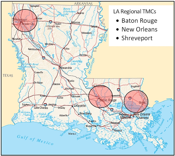
The Statewide TMC is located in Baton Rouge and oversees all field equipment and operations of the regional TMCs along with field equipment located in areas not covered by the regional TMCs. The Statewide TMC handles all regional based incidents and construction projects. It operates 24/7 and provides after-hour coverage for the regional TMCs.
The Shreveport TMC handles most of the northwest Louisiana area, including Shreveport and Bossier City and the surrounding areas. The interstates located within this area are I‑20, I-220, and I-49.
The Baton Rouge TMC covers East Baton Rouge Parish and surrounding areas including Denham Springs, Port Allen, and Prairieville. Several major interstates and junctions are located within the Baton Rouge area I‑10, I-12 and I-110.
The New Orleans TMC covers the greater New Orleans area, Kenner, Laplace, and the Northshore. I‑10 and I-610 are within the New Orleans area, and I-12 runs through Hammond and Covington on the Northshore. The Houma TMC is located in Terrebonne Parish and is supervised by the New Orleans TMC. US 90 runs north of Houma and is covered by the Houma TMC operator.
Any incidents or construction in these areas are handled by the regional TMC. Each TMC can assist in any incident by activating Dynamic Message Signs, notifying key personnel, dispatching MAP and entering the incident into the 511/CARS system. The TMCs work cohesively to assure all incidents, construction and other projects are proficiently handled.
1.4 Weather Integration Self-Evaluation Process
A group of representatives from each TMC gathered to discuss the methods to develop the weather integration plan. It was decided that the most effective approach would be to separately complete the self-evaluation for each regional TMC. The Statewide TMC operations area was split into two sections, Northeast and Southwest, in order to account for the areas not covered by a regional TMC. After completing these separate self-evaluations, each TMC was assessed, and it was determined that one set of strategy outputs could represent the entire state due to the significant similarities in the self-evaluation results of all the TMCs.
Although tropical weather activity, hurricanes, and their effects on the roadways are a major concern in Louisiana, they were not included in the self-evaluation because there currently are substantial plans and policies in place at each TMC to handle these occurrences.
After combining the results from all the TMCs and deciding to have a single weather implementation plan for all the TMCs, it was observed that there is a large gap between the current level of weather integration and the target level. The target level is defined in the Guide as the level to be reached to fully meet the desired weather integration need. It was decided that each TMC would approach the final level in steps; start with small goals and reevaluate using the Louisiana implementation plan until the target level is finally reached.
1.5 Relationship to Other Plan Documents
Previously, weather integration by the TMCs was only approached from a hurricane perspective. Hurricane evacuation plans and other related policies have been in place by DOTD since before the TMCs were established and have continually been reworked throughout the years.
2 TMC Weather Integration Plan
This section explains the TMC Operations Staff’s experiences with the Guide and the plan formed from the observations and results of the self-evaluation process.
2.1 Existing Weather and Transportation Management Systems
The existing transportation management systems within the TMCs are currently used by the TMC Operations Staff under the policies of the Standard Operating Procedures (SOPs) written for each center. Operators use CCTV cameras, 511/CARS traveler information system, DMSs, and VDs to monitor conditions and advise motorists in the event of abnormal conditions.
2.1.1 Internal DOTD Weather Resources
The Road Weather Information System (RWIS) deployed by DOTD has been decommissioned due to maintenance and operational issues. Fog sensors were placed in strategic areas experiencing high occurrences of fog. These sensors are no longer active due to many operational issues the state faced. These issues have led DOTD to be cautious about investing anymore money into weather sensing equipment. DOTD is content with primarily using CCTV cameras as secondary fog sensors.
Today the TMC Operations Staff receive weather condition information from local weather broadcasts. Road closures due to flood or ice are received from the State Police. These closures and advisories are entered into 511/CARS and posted on DMS to inform motorists. Weather radios are in place at each TMC to alert operators of severe weather and storm warnings.
2.1.2 External Resources
The TMC Operations Staff at each TMC have access to the Internet and cable TV where weather conditions and forecasts can be monitored daily. Weather events are tracked through the National Weather Service and other sources such as www.weatherunderground.com, www.weather.com, NOAA, the Weather Channel, and television’s weather reports.
2.1.3 Decision Support Systems
Each TMC follows a SOP document, which outlines policies for activities and notifications to the public. No policies on weather-related events are in the SOPs; however, the TMC Operations Staff have been following consistent practices. These practices in place at each TMC for weather events will be written into the SOPs.
Currently, flooding, fog, and winter conditions are the only weather-related events that are handled by the TMCs. In the event of flooding, State Police send road closure reports directly to the TMC, and these are entered in the 511/CARS system. These reports are only sent after the road has been closed. There is no forewarning that a road may close from expected large amounts of rainfall. Fog is handled by the TMCs by activating DMS during a fog advisory. Fog advisories are put into place when the local weather station broadcast has stated a fog advisory is in effect. The TMC takes no action in regards to high winds and severe weather, other than monitoring the conditions and lending support if an incident occurs.
2.2 Concepts of Operations
By taking a more proactive approach, receiving information before adverse weather conditions occur, and having set policies and procedures in place, the TMC Operations Staff can better prepare to handle the weather-related traffic impacts and incidents that may occur. The first goal of the TMC Operations Staff is to gather information and data before weather events occur. Through better communications with field operators, construction personnel and DOTD, the TMC Operations Staff hopes to put plans in place to more effectively handle adverse weather events. The TMC Operations Staff envisions receiving weather information in a standard format stating the type of weather event, location (along what stretch of highway), time of the event, and its potential impacts to traffic prior to or as soon as a weather event starts. Potential sources for this information could include MAP, state and local police, weather-based information sites, and other operators monitoring CCTV cameras.
In order to decide what policies and procedures would be most beneficial for the TMCs, potential pilot sites are being proposed in areas on interstates that are most susceptible to adverse weather conditions. The plans and policies for these potential pilot sites are anticipated to be written for proposal over the next year. The locations evaluated for pilot sites include long bridges over large waterways where fog and/or ice are expected.
2.3 Identified High Priority Needs
These items are identified by the TMC Operations Staff as the goals that must be reached first in order to properly integrate weather information into the TMC operations. The needs identified in the table below are from the Guide.
| Louisiana Needs | Definition |
|---|---|
| Advisory Operations | |
| LA-1 | Improve targeting of weather messages (site-specific; user group specific) to more effectively convey road weather information. |
| LA-2 | Improve message content (for DMS, 511/CARS, Highway Advisory Radio (HAR), websites, etc.) |
| Institutional Coordination | |
| LA-3 | Develop and implement clear, written policies and procedures for handling weather events. |
| Gathering and Processing Weather Information | |
| LA-4 | Assistance interpreting weather information and how best to adjust operations in light of that information. |
| LA-5 | Improve the coverage and granularity of weather information in the region with the increased use of weather stations. |
| LA-6 | Better real-time information on road conditions during weather events. |
2.3.1 Advisory Operations
The combined high priority needs, LA-1 and LA-2, are intended to assist in increasing motorist information. This includes better informing motorists of weather conditions prior to getting on the road and while on the road. An informed motorist can make better pre-departure decisions, and an already en-route motorist can make better decisions for upcoming driving conditions.
2.3.2 Institutional Coordination
Institutional coordination refers to the need to develop and implement clear, written policies and procedures for handling adverse weather events. Currently the SOPs in place do not include specific sections relating to weather events other than hurricanes. With the help of this weather integration plan, the TMC Operations Staff is going to develop clear and concise strategies on how to best respond and handle weather events and eventually include them in the TMCs’ SOPs.
2.3.3 Gathering and Processing Weather Information
The three high priority needs under this section, LA-4, LA-5, and LA-6, all deal with receiving and organizing information that helps to inform the TMC of conditions and consequently enables a more proactive approach. By actively receiving and monitoring weather-related information, the TMC can better prepare in advance for adverse weather conditions. The more usable the data, the better the TMCs can make decisions on the weather events.
Improvements to the policies for receiving and relaying information which are already in place must be made in order to reach the level required by the Guide and selected by the TMCs to reach the TMCs’ goals. As data is collected from internet sources, the TMCs’ current 511/CARS system, email distribution, DMSs, and advisories will be used to efficiently disseminate information to outside agencies and the public.
2.4 Integration Solutions
The Guide lists 11 Items of Integration and 5 levels of Integration Strategies, as shown in the table below.
| Items of Integration | Strategies | ||||
|---|---|---|---|---|---|
| Level 1 | Level 2 | Level 3 | Level 4 | Level 5 | |
| Use of Internal Weather Information Resources | Camera imagery | Radar, satellite, Automated Surface Observing System (ASOS) and Automated Weather Observing System (AWOS) data, and general zone-type forecast information | Level 2 data plus data from Road Weather Information Systems (RWIS) and related networks | Level 3 data plus data from Automatic Vehicle Locations/Mobile Data Computers (AVL/MDC) sources and internal radio communications | Level 4 data with addition of analyzed fields and transformed data parameters (frost index, wind chill, est. snow, ice, water depth) |
| Use of External Weather Information Sources | General weather information, forecasts, and interpretation provided through media as irregular service (radio and TV weather) | Internet provided, public access general forecasts, weather radar or satellite image or weather-specific broadcast channel | Field observers or probes providing scheduled weather / driving condition information from entire route system | Contractor provided surface transportation weather forecasts targeted at the operational needs of the TMC agencies | Direct connection between private weather information service providers and traffic management software |
| Availability of Weather Information | Cable channel or subscription weather information vendor providing general weather information | Internet provided weather radar or satellite image on video wall | Field observers or Environmental Sensor Station (ESS) network providing scheduled road or driving condition reports | Vendor provided daily surface transportation weather forecasts and observed weather conditions including Level 3 | Meteorologist, located within TMC, forecasting and interpreting weather |
| Frequency of Weather Forecasts | Receive information of weather forecasts on a request basis | Receive weather forecast once daily. | Receive periodic forecasts several times a day | Receive hourly updates of weather forecasts several times a day | Receive continuous updates of weather forecasts in real-time |
| Frequency of Weather/Road Weather Observations | Receive information of weather conditions on a request basis | Receive weather observations once hourly | Level 2 plus receive weather/road weather observations when predefined thresholds have been exceeded | Receive weather/road weather observations every ten minutes and when predefined thresholds have been exceeded | Receive weather/road weather observations continuously with data above predefined thresholds highlighted |
| Weather Information Coordination | Intra-TMC committee tasked with weather information coordination | Identified TMC or maintenance staff member tasked with coordinating weather information at TMC | Dedicated weather operations supervisor | Meteorology staff located within the TMC forecasting and interpreting weather information | Co-location of the Emergency Operations Center/Office of Emergency Management (EOC/OEM) |
| Extent of Coverage | Sparse Set of Isolated Locations | Network of Scattered Locations | Corridor-level | Multiple-corridor/sub-regional | Regional/Statewide |
| Interaction with Meteorologists and Climatologists | Focus group or informal gatherings of local professionals from the transportation management and weather communities | Develop check list of routine weather awareness activities | Periodic staff meeting that includes a meteorologist to discuss weather information needs and responses | With a meteorologist present conduct post-event debriefing / regular assessment to fine-tune responses | Daily personal briefings and integrated interruptions by meteorology staff within the TMC |
| Alert Notification | Monitor media outlets, Internet page, or data stream for critical events | Telephone call list | Manual email/paging system | Automated TMC road weather system-generated notifications (e.g., Email or page from Road Weather Information System or Flood Early Warning System) | Automatic notification through Center-to-Center communications |
| Decision Support | Ad-hoc implementation of weather management strategies | Use quick-reference flip cards on operator’s workstation to implement predefined response | Response scenarios through software supply potential solutions with projected outcomes based on weather / traffic modeling | Automated condition recognition and advisory or control strategy presented to operator for acceptance into ATMS | Automated condition recognition and advisory or control strategy implemented without operator intervention |
| Weather/Road Weather Data Acquisition | Media Reports | Internet and/or Satellite Data Sources | Across agency intranet and dedicated phone acquisition | Dedicated communications link to state, federal, private data sources | Dedicated communications link to state, federal, private data sources including vehicle-derived weather data |
The TMC Operations Staff was able to determine what levels the TMCs are currently operating under and what intermediate levels are needed to be achieved. Based on the needs selected, the target levels of integration were determined by the Guide. Intermediate levels were chosen to provide smaller steps to achieve the target level. Once the selected intermediate steps have been reached, the TMC Operations Staff will reassess how to approach the next level of integration. This process is repeated until the target level is achieved. The following table summarizes the current level of integration, selected intermediate level, and target level defined by the Guide.
| Items of Integration | Strategies | ||
|---|---|---|---|
| Current Level | Intermediate Level | Target Level | |
| Use of Internal Weather Information Resources | 2 | 3 | 4 |
| Use of External Weather Information System | 2 | 3 | 4 |
| Availability of Weather Information | 2 | 3 | 4 |
| Frequency of Weather Forecasts | 0 | 2 | 4 |
| Frequency of Weather/Road Weather Observations | 0 | 2 | 4 |
| Weather Information Coordination | 0 | 2 | 4 |
| Extent of Coverage | 0 | 2 | 5 |
| Interaction with Meteorologists and Climatologists | 0 | 2 | 3 |
| Alert Notification | 1 | 1 | 4 |
| Decision Support | 1 | 2 | 3 |
| Weather/Road Weather Data Acquisition | 2 | 2 | 4 |
The following sections contain recommended solutions to meeting the selected and future target levels. All recommendations are subject to DOTD approval and agreement from the other affected agencies indicated.
2.4.1 Use of Internal Weather Information Resources
The current integration level identified by the TMC Operations Staff when the Guide was initially started is Level 2, which includes the use of camera imagery, radar, satellite, and general zone-type forecast information. The target level for the TMCs based on their needs is a Level 4, which includes the use of data from Automated Vehicle Locator/Mobile Data Computer (AVL/MDC) sources and internal radio communications. The integration’s intermediate level chosen to be reached by the TMC Operations Staff is Level 3, which includes the use of data from Level 2 plus data from RWIS and related networks.
In order to address the strategies and solutions given by the Guide, RWIS systems could be deployed. Placing RWIS at existing DMS sites and/or other existing powered sites could minimize costs. However, due to past experience with RWIS, DOTD is not willing to provide funding at this time for implementing RWIS systems.
The use of existing RWIS sites is another option for the TMCs. There are RWIS sites that are managed and operated by Louisiana State University (LSU). The information gathered by these sites is public. In most cases, these RWIS sites are not located in relevant positions along the interstates. However, it may be beneficial to utilize the feasible sites and further explore the types of data and collection methods used by this system for its applicability in the future RWIS deployments for the TMCs.
2.4.2 Use of External Weather Information System
Through the use of the Internet, public access general forecasts, weather radar, satellite imagery and the weather-specific broadcast channels, the TMCs currently have a Level 2 integration status in their use of external weather information systems. The self-evaluation Guide suggested the target level for the TMCs, based on the needs requested, should be a Level 4, which includes contractor-provided public access general forecasts, weather radar, satellite imagery or weather-specific broadcast channels. It was decided by the TMC Operations Staff that contractor-provided forecasts were not needed by the TMCs at this time.
The TMCs chose the intermediate Level 3, which includes field observation or probes providing weather/driving condition information from the entire route systems. Louisiana currently interacts through radio correspondence with the MAP operators. MAP vans patrol the interstates in the Baton Rouge, Shreveport, New Orleans, and Lake Charles areas and assist with incident management and lane blockage. Within the weather integration plan, MAP operators would give information on roadway conditions with real-time data and locations of nearby weather events, enabling the TMC Operations Staff to handle these events proactively. In addition to the reports given by MAP operators and the State Police would be asked to send reports of roadway conditions, which would also help ensure the safety of motorists on the roadway. State Police will be contacted once this plan is in place to discuss these potential collaboration efforts.
2.4.3 Availability of Weather Information
As previously mentioned, the TMCs have Internet-provided weather radar and/or satellite images that can be displayed on the video wall or computer monitor(s). If there is a major weather event, it is projected on the video wall within the TMC. This places the TMCs at an integration Level of 2. The goal is to reach level 4, which includes accomplishing all tasks from Level 3 (having field observers or Environmental Sensor Station (ESS) networks providing scheduled road or driving reports). Level 4 requires obtaining daily surface transportation weather forecasts and observed weather conditions from outside agencies or contractors, such as State Police and local weather forecasters, in order to gain more real-time data.
2.4.4 Frequency of Weather Forecasts
Currently there are no weather forecasts being received by the TMCs. Level 2 status is achieved by receiving weather forecasts at least once daily from a reliable weather source as well as from field sources (e.g., MAP operators and/or local police officers). All TMCs will be required to register for their own local weather updates, so they will be informed of any adverse weather in their surrounding area. Also, these reliable weather sources will send email updates on severe weather days, and once daily the TMCs will be updated on all current weather in the area. This is going to be achieved by registering the TMCs for alerts through the local media alert systems. Currently the Statewide TMC receives notification of flooding from the State Police, only after the police have closed the road. The police fill out a form that has been set up to inform the TMC Operations Staff of the location and details of incidents.
2.4.5 Frequency of Weather/Road Weather Observations
The Guide identified the target integration to be Level 4 (receive weather/road weather observations every ten minutes and when predefined thresholds have been exceeded), but the TMC Operations Staff chose Level 2, which is to receive road weather observations hourly. The goal of the TMC is to utilize MAP and State Police and receive weather reports of real-time road data hourly, but only on adverse weather days.
Since MAP patrols many sections of interstate, this is the best way for the TMC to collect real-time data. This would bring the TMC up to Level 2 status of receiving road weather observations hourly. In order to implement this strategy, MAP policy would have to be discussed and rewritten. Also, State Police emails and phone calls could inform the TMC Operations Staff of adverse weather conditions on the roads statewide. By implementing a procedure for MAP and State Police to follow, information can be given to the TMC Operations Staff for taking a more proactive approach to weather. Utilizing people and programs already in place will allow the TMCs to reach their goal of becoming more weather-responsive, while maintaining lower costs at the same time.
CCTV cameras already in place can also be utilized for weather observation. Monitoring weather through CCTV cameras is the fastest way for the operators to confirm weather information in the field. Another source that could be utilized is the local RWIS systems set in place by LSU, as previously discussed in section 2.4.1.
2.4.6 Weather Information Coordination
TMC Supervisors have discussed integrating weather information coordination into daily operations, but there currently is no policy in place at the TMCs. The target level recommended by the Guide to meet the TMCs required needs is a Level 4, which includes having a meteorology staff located within the TMC to forecast and interpret weather information. Because of Level 4’s associated cost, the TMC Operations Staff has decided to set a goal of reaching a Level 2. This would require identifying a TMC operator tasked with coordinating weather information for the TMC.
It is recommended that an existing TMC operator at the Statewide TMC be assigned the duties of the weather coordinator. The weather coordinator’s responsibilities would include collecting data and distributing the information to the regional TMC supervisors, MAP operators, maintenance staff, and field engineers. The Statewide TMC Operator, weather coordinator, would alleviate the need for a weather coordinator at each individual TMC. Policies will be developed, so each TMC operator will know how to handle weather information received and how to respond to weather events at any time of the day. Policies will also be put in place by the weather coordinator for operations during large scale forecasted weather events.
2.4.7 Extent of Coverage
Currently there are no RWIS sensors in place recording information or being monitored by the TMC Operations Staff. The Guide placed the target integration level of the TMC at a Level 5, which requires expanding the extent of coverage to a network of sensors to provide weather information for the entire state. Due to cost considerations, the TMC Operations Staff is hoping to ultimately reach a Level 4 status, which includes a network of RWIS sensors to provide weather information from multiple corridors and regions. The short-term plan is to reach a Level 2 status, which will expand the extent of coverage to a network of sensors from scattered locations. A long-term plan is needed to establish more widespread deployment of RWIS sensors and to research all the different types of possible weather sensor strategies that may be deployed. The three potential pilot sites being proposed are:
2.4.7.1 Atchafalaya Basin Bridge
The Atchafalaya Basin Bridge is an 18 mile long bridge on I-10, which spans across the Atchafalaya Basin between Baton Rouge and Lafayette. The Basin Bridge is highly vulnerable to heavy fog and rain events.
2.4.7.2 Bonnet Carre Spillway
The Bonnet Carre Spillway Bridge is a 12 mile long bridge on I-10, which runs between Laplace and Kenner to the west of the New Orleans area. The Spillway Bridge is highly vulnerable to heavy fog and rain events.
2.4.7.3 Red River Bridge
The Red River Bridge is located on I-20 between Shreveport and Bossier City. During winter months the bridge is susceptible to ice and freezing rain.
2.4.8 Interaction with Meteorologists and Climatologists
The Guide placed the TMC target level at Level 3, which would require periodic staff meetings along with a meteorologist to discuss weather information needs and responses. The TMC Operations Staff decided to make the goal a Level 2, which calls for the development of a checklist of routine weather awareness activities. Also included in this would be the Level 1 requirements of forming a focus group of local professionals from the transportation management and weather communities, such as local climatologists and meteorologists.
Currently the state climatologist is located at Louisiana State University. Previously there has been no communication among the TMC Operations Staff and the climatologist; however, the TMC Operations Staff wishes to form a relationship with the climatologist in order to receive information regarding flood events and to better choose sites to deploy equipment. Also, some educational training by a meteorologist or climatologist will benefit each operator in understanding weather and its potential hazards.
2.4.9 Alert Notification
The current level of the TMC is Level 1, which includes the monitoring of critical events through media output, along with the use of weather radios, which are currently in place at each TMC. The TMC Operations Staff discussed future plans that would allow them to receive notifications from the weather coordinator and weather sensors in the field, but at this time the TMC Operations Staff would like to remain at a Level 1.
2.4.10 Decision Support
Currently all TMCs have a Level 1 status, but the Guide recommended reaching the Level 3 status, which requires response scenarios supplied through software to identify potential solutions with projected outcomes based on weather and traffic modeling. The TMC Operations Staff decided the first strategy to be implemented would be Level 2’s use of quick reference flip cards on operators’ workstations to implement refined response.
Currently no set manuals or plans are written out for how the TMC Operations Staff responds to weather events. The TMC Operations Staff look to implement a weather manual, within the current SOP, with instructions on how to handle specific weather incidents, along with quick reference flip cards on operators’ workstations to implement predefined responses.
2.4.11 Weather/Road Weather Data Acquisition
Currently the TMCs receive weather and road data through the Internet, television, and weather radar outputs. This puts the TMCs at a Level 2. The Guide recommends reaching Level 4, which requires having a dedicated communications link to state, federal, and private data sources. The TMC Operations Staff have decided to remain at the current level.
2.5 Future Plans
2.5.1 Annual Revisiting of Process
It is recommended that the Guide be revisited each year to verify the TMCs’ progress. Since the TMC Operations Staff chose lower, or intermediate, levels of integration instead of the higher target levels of integration provided by the Guide, revisiting it each year will help to determine new sets of strategies and levels based on the TMCs’ current status. Through this process the TMCs will be able to reach the target levels efficiently, one step at a time.
3 Implementation of Integration Plan
The Guide lists 11 separate integration strategies that help manage different areas of integrating weather into TMC operations. After reviewing all the strategies it was decided that many of these strategies can be implemented by utilizing the same resources; therefore, the TMC Operations Staff decided to combine these strategies and organize them in the order in which they are to occur. With the integration plan completed, weather integration will be implemented at each TMC during the next two years.3.1 Integration Activities
Several activities will be started by the TMC Operations Staff during the implementation process. Most will begin with a written Memorandum of Understanding (MOU) and changes to policies and procedures. With these changes, the roles of the TMC Operations Staff when responding to weather-related events will change, becoming more proactive in response to road/weather information. Activities that will be started at the TMCs during the initial integration of weather information include writing the policies and procedures to integrate weather and traffic information, coordinating with MAP operators and State Police on weather/road observations and reporting.
3.2 Implementation Sequencing
3.2.1 Implementation Timeframe
There are currently several projects under construction by DOTD that are placing CCTV cameras and DMSs in the New Orleans and Lafayette areas. With the installation of new equipment to inform travelers and to be able to monitor incidents and traffic, the TMC Operations Staff will be better-equipped to handle weather-related events proactively. The first two years of the plan will be devoted to developing plans and policies and acquiring data in order to provide the necessary resources to manage weather events.
3.2.2 6 months
In the next 6 months the TMC Operations Staff plan to identify all weather information sources such as MAP, State Police, and LSU. These sources were discussed in the first through fifth and eighth integration strategies. The flow of information will be discussed, so the information can be received and properly used. The goals and plans of the TMCs will be established, making all participating groups aware of them. Also within this timeframe a weather coordinator will be appointed to write, implement, and direct this plan.
3.2.3 12 months
Concurrent with the first set of goals, in the next 12 months, the TMC Operations Staff plans to develop policies and procedures. These policies and procedures will be developed in order for the flow of information to be utilized properly and efficiently. In these policies and procedures, definitions of advisory thresholds will be defined for statewide consistency. Although agencies and equipment will be different among the TMCs, the standard operating procedures will be the same for each TMC. Also during this time, the pilot sites will be established, and DOTD will develop detailed road device deployment plans for the sites which were discussed earlier, such as the Atchafalaya Bridge, Bonne Carre Bridge, and Red River Bridge.
3.2.4 18 months
Within the next 18 months, the pilot sites will be tested. During this time the weather coordinator will collect data, and the policies and procedures will be followed in order to ensure that the potential pilot sites are operating correctly. These pilot sites will help to determine the usefulness of the equipment and resources.
3.2.5 24 months
Within the next two years, the TMC Operations Staff will update the integration plan in order to identify the next steps in the weather integration process. Since the TMC Operations Staff chose an intermediate level, with the ultimate goal being the target level the Guide originally provided, the Guide will be revisited each year until the TMC Operations Staff and DOTD have made all the desired improvements for weather integration.
The following table lists the integration strategies previously discussed, implementation timeframe, and the sequence in which they should be reached.
| Items of Integration | Implementation Timeframe | Implementation Sequencing |
|---|---|---|
| Use of Internal Weather Information Resources | 1 year | 1 |
| Use of External Weather Information System | 2 years | 2 |
| Availability of Weather Information | 2 years | 2 |
| Frequency of Weather Forecasts | 1 year | 1 |
| Frequency of Weather/Road Weather Observations | 1 year | 1 |
| Weather Information Coordination | 2 years | 3 |
| Extent of Coverage | 5-10 years | 4 |
| Interaction with Meteorologists and Climatologists | 2 years | 1 |
| Alert Notification | 2 years | 3 |
| Decision Support | 2-3 years | 3 |
3.3 Costs Estimates
Table 5 lists the anticipated costs of the integration strategies. Each strategy’s initial cost and maintenance cost per year were estimated. The sections following the table explain what these costs include and how they were determined.
| Items of Integration | Initial Costs | Maintenance Costs/year |
|---|---|---|
| Use of Internal Weather Information Resources | $50,000 | $7,500 |
| Use of External Weather Information System | $0 | $0 |
| Availability of Weather Information | $2500 | $375 |
| Frequency of Weather Forecasts | $1500 | $225 |
| Frequency of Weather/Road Weather Observations | $2000 | $300 |
| Weather Information Coordination | $6500/year | $0 |
| Extent of Coverage | $250,000 | $37,500 |
| Interaction with Meteorologists | $2,000 | $0 |
| Alert Notification | $0 | $0 |
| Decision Support | $0 | $0 |
3.3.1 Use of Internal Weather Information Resources
Initially, two RWIS stations could possibly be deployed along the first pilot site, Atchafalaya Basin, in order to test weather coordination within the TMCs. This cost estimate of $50,000 includes two RWIS stations, furnished, installed and integrated with the TMC (~$25,000 each). $7500 is required for annual station maintenance and repairs.
3.3.2 Availability of Weather Information
An estimated $2500 is needed to pay for upgrading communications between the TMC Operations Staff and the MAP operators. These upgrades would include access to weather radios, ESS networks, and handheld radios that would allow TMC operators to communicate with MAP operators. Continued annual maintenance of the required communications software is estimated to cost about $375 a year.
3.3.3 Frequency of Weather Forecasts
Subscriptions to private services offering daily weather forecasts and the development of MOUs between the TMCs and any public agencies providing the weather forecasts are estimated to cost $1500. $225 is the projected annual cost of renewing the subscriptions.
3.3.4 Frequency of Weather/Road Weather Observations
The cost estimate for Frequency of Weather/Road Weather Observations is based off the labor cost needed to develop MOUs among the TMC Operations Staff, MAP operators and State Police.
3.3.5 Weather Information Coordination
The estimated cost for Weather Information Coordination is budgeted for a possible salary increase for the weather coordinator. This person would ultimately be responsible for weather integration and weather response statewide, as part of his or her daily TMC operator responsibilities.
3.3.6 Extent of Coverage
Currently there is no DOTD weather reporting in the State. This cost estimate includes system engineering, design, deployment and maintenance of additional pilot sites along the Atchafalaya, Bonnet Carre, and Red River Bridges. These sites would be used to monitor the bridges during weather events. Based on the length of the bridges, up to 10 stations have been estimated for deployment for each pilot site $250,000 is needed to furnish, install and integrate the RWIS sites (~$25,000 each). $37,500 is needed annually to maintain the RWIS stations.
3.3.7 Interaction with Meteorologists and Climatologists
The cost estimate for interaction with meteorologists and climatologists is for costs associated with developing the MOUs that are to be executed for obtaining training from the meteorologists and climatologists. Costs for the training and information received from the meteorologists and climatologists will be discussed and determined at a later date.
3.3.8 Alert Notification and Decision Support
Alert Notification and Decision Support have no associated costs because they will be the responsibility of the weather coordinator. These items will be identified under the policies and procedures.
3.3.9 Initial Costs
Initially there should be no start up costs to implement new policies and procedures into the TMCs. This assumption is based off the idea that most initial work will include changing policies, gathering information, and using free resources. By working with contracts and people already in place at the TMCs there are no expected initial costs. Once equipment is installed, the associated costs will cover deployment of the equipment and maintenance costs such as staffing, support of equipment and training.
3.3.10 Life-Cycle Costs
Currently the total Life-Cycle Costs associated with operating and maintaining the hardware and software components of the system cannot be estimated because the general plan for the first two years does not included specific software and hardware that will be utilized.
3.4 Operations and Maintenance Requirements
3.4.1 Staffing
All new policies and procedures implemented during this plan can and will be handled by the operators currently employed by the TMC.
3.4.2 Support
Maintenance and support will be necessary after the test equipment is installed. It is estimated that the cost of the maintenance and support will be about 10 to 15% of the total cost of the initial estimate per year.
3.4.3 Training
Training for all operators may be required for new RWIS systems and software functions. This cost estimate is minimal and is included under maintenance costs.
3.5 Anticipated Challenges and Constraints
The major anticipated challenge and constraint of weather integration is its cost. Any cost limitations that arise must be resolved before major equipment is deployed.