
Wyoming Department of
Transportation
![]()
Statewide Transportation
Management Center (TMC)

WEATHER INTEGRATION PLAN
December 15th, 2010
ACKNOWLEDGEMENTS
We wish to thank all those involved with the development of this plan; for their contributions both to this plan as well as their contributions to the plan development process.
- Chad Hahn, Senior Forecaster, National Weather Service
- Ken Shultz, P.E., State Maintenance Engineer, WYDOT
- Tim McGary, P.E., District Maintenance Engineer, WYDOT
- Captain Bill Morse, Patrol Dispatch Supervisor, WYDOT
- Cliff Spoonemore, P.E., Winter Research Services, WYDOT
- Vince Garcia, P.E., GIS/ITS Program Manager, WYDOT
- Chris Cluett, Research Leader, Battelle
- Fred Kitchener, McFarland Management
- Deepak Gopalakrishna, Principal Research Scientist, Battelle
- Roemer Alfelor, Office of Operations, FHWA
Without their support and knowledge, the development of this plan would not have been possible.
Prepared by:
Kevin M. Cox, P.E.
Intelligent Transportation Systems Engineer
Transportation Management Center
Wyoming Department of Transportation
TABLE OF CONTENTS
- 1. Introduction
- 2 Existing Road Weather Management Systems
- 3 Concepts of Operations
- 4 Integration Needs
- 5 Integration Solutions
- 6 Implementation of Integration Plan
- Appendix A – Summary Report of Weather Events
- Appendix B – Summary Report of Impacts Due to Weather Events
- Appendix C – Summary Report on Current Integration Level
- Appendix D – Summary Report on TMC Operational Needs to Be Addressed by Better Weather Integration
LIST OF TABLES
- Table 1 – List of RWIS Locations
- Table 2 – High Priority Needs
- Table 3 – Summary of Integration Strategies
- Table 4 – Project Timeline and Costs
LIST OF FIGURES
ABBREVIATIONS AND ACRONYMS
ASOS |
Automated Surface Observing Systems |
ATMS |
Advanced Traffic Management System |
AVL |
Automatic Vehicle Location |
AWOS |
Automated Weather Observing Systems |
DMS |
Dynamic Message Signs |
ECAR |
Enhanced Citizen-Assisted Reporting |
EOC |
Emergency Operations Center |
ESS |
Environmental Sensor Station |
FHWA |
Federal Highway Administration |
HAR |
Highway Advisory Radio |
ITS |
Intelligent Transportation Systems |
MDC |
Mobile Data Computer |
MDSS |
Maintenance Decision Support System |
OEM |
Office of Emergency Management |
RWIS |
Road Weather Information System |
RWMP |
Road Weather Management Program |
SALECS |
State Law Enforcement Communications System |
TMC |
Transportation Management Center |
VSL |
Variable Speed Limit |
WHP |
Wyoming Highway Patrol |
WIM |
Weather Information Manager |
Wx |
Weather |
| WYDOT | Wyoming Department of Transportation |
1. Introduction
1.1 Background
The Federal Highway Administration’s (FHWA) Road Weather Management Program (RWMP) has established a programmatic road map that identifies the integration of weather information into the operations of Transportation Management Centers (TMCs) across the country as a key objective. Integrating weather information supports the capability of state and local transportation agencies to better manage their traffic, dispatch maintenance crews and respond appropriately and in a timely way to weather-induced problems affecting the transportation system. Well-integrated weather information allows TMC operators to make effective and timely management and operational decisions based on quality information related to weather forecasts, the anticipated timing and intensity of weather events, and the interaction of weather conditions with the road surface. Integrated weather information positions a TMC to be proactive rather than reactive with regard to the operations and maintenance of their transportation infrastructure. The FHWA has prepared a detailed self-evaluation “Guide” that assists TMCs in identifying appropriate weather integration strategies, given their current level of weather integration and where they would like to be with regard to enhanced integration and to prepare a weather integration plan based on strategies suggested by the self-evaluation.
1.2 Purpose
The WYDOT Statewide Transportation Management Center (TMC) was chosen by the FHWA to conduct a weather information integration self-evaluation and planning process (using a provided Guide) and provide feedback. The Guide was prepared in an electronic form (Microsoft Access) that walks the user through several sections to eventually result in the identification of potential weather information integration strategies that a TMC may consider for future enhancements to their operations. The WYDOT Statewide TMC was chosen because of their strong interest in improving their use of weather information in support of their operations and to better manage the extreme weather events experienced throughout the state. The TMC was asked to review the Guide and provide feedback that will be used to improve the Guide. As part of this activity, WYDOT was asked to develop a weather integration plan. This document is that plan.
Since the jurisdiction for WYDOT’s TMC is statewide, this plan was undertaken as part of an effort to develop a weather integration strategy for the entire state of Wyoming. In addition, this effort was to aid developers with the final design of the FHWA’s Weather Integration Self-Evaluation and Planning Guide.
1.3 TMC Overview
WYDOT’s statewide TMC became operational in the Fall of 2008. The TMC is housed in the basement of the Qwest building at 6101 Yellowstone Road in Cheyenne, Wyoming, approximately a mile north of the WYDOT headquarters complex. The TMC houses both the emerging Intelligent Transportation Systems (ITS) operations function and a new dispatch center for the Wyoming Highway Patrol.
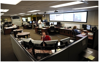
While numerous states already have similar TMCs in operation to deal with urban traffic congestion, Wyoming’s center is geared almost exclusively toward rural travel management and information needs that result from extreme weather conditions. Additionally, it is one of the few TMCs where communication services for DOT construction, traffic, and maintenance functions are co-located with law enforcement.
1.4 Key Functions of WYDOT’s TMC
The functions of the TMC have expanded over time, but the core functions can be grouped into the following four main areas:
- Monitoring and control of roadside ITS devices such as web cameras, road weather information systems (RWIS), variable speed limit (VSL) signs, dynamic message signs (DMS), highway advisory radios (HAR), flashing beacons, and road closure gates;
- Serving as a law enforcement communications hub for state and federal agencies by maintaining frequent contact with Highway Patrol troopers and other personnel via the State Law Enforcement Communications Systems (SALECS);
- Managing communication with the traveling public via the 511 Travel Information Service (telephone and internet components) and direct contact with media outlets, visitor centers, and truck stops;
- Receiving and relaying road and weather reports from volunteers participating in the Enhanced Citizen-Assisted Reporting (ECAR) program, as well as, dispatching WYDOT construction and maintenance crews throughout the state.
1.5 Weather Integration Self-Evaluation Process
WYDOT was first introduced to the Weather Information Integration Self-Evaluation and Planning Guide on April 22nd, 2009. On May 18th, 2009, WYDOT conducted a meeting to work through the Guide with a team of stakeholders from WYDOT Maintenance, Winter Research Services, the Transportation Management Center, Highway Patrol Dispatch, and the National Weather Service. During this two-hour meeting, the stakeholders worked their way through the Guide, answering the questions collectively as a group. The stakeholders included the following individuals:
- Chad Hahn, Senior Forecaster, National Weather Service, Cheyenne
- Ken Shultz, P.E., State Maintenance Engineer, WYDOT, Cheyenne
- Tim McGary, P.E., District Maintenance Engineer, WYDOT, Laramie
- Captain Bill Morse, Patrol Dispatch Supervisor, WYDOT, Cheyenne
- Cliff Spoonemore, P.E., Winter Research Services, WYDOT, Cheyenne
- Vince Garcia, P.E., GIS/ITS Program Manager, WYDOT, Cheyenne
- Kevin Cox, P.E., ITS-Systems Engineer, WYDOT, Cheyenne
Selected output from the Guide is included in the appendices.
1.6 Relationship to Other Plan Documents
This section lists current and proposed documents that help guide the TMC’s practices and operations. Along with the name of each document is a brief description of its relationship to this Weather Integration Plan.
- Wyoming Statewide Intelligent Transportation (ITS) Architecture - This document produced by WYDOT was published in April 2006. It updated the previous ITS Strategic Plan that WYDOT had been operating under since 2002. This document serves as a high-level guide for ITS infrastructure deployment, compliance with ITS standards, and multi-jurisdictional coordination. It relates to TMC weather integration by providing a good planning reference for future ITS deployments, and guidance on how WYDOT communicates with surrounding states during storm events.
- WYDOT Transportation Management Center Concept of Operations – This document produced by WYDOT was adopted in March 2005. It was the primary planning document used to design, build and staff WYDOT’s TMC. This document represented the culmination of several years work to identify the TMC requirements and the entire systems engineering process. This document is relevant to the TMC weather integration because it provides several examples of operational scenarios that involve winter weather maintenance and traveler information.
- Variable Speed Limit (VSL) Policy Memorandum – This policy has been developed over the past two years to provide WYDOT with an interim process by which appropriate speeds can be determined and posted on VSL signs. The current policy relies heavily on speed sensor data for determining speed, but the TMC operators, Highway Patrol, and maintenance personnel also use whatever weather information is available to assist in establishing an appropriate speed for conditions.
- Proposed VSL Control Strategy – This document and process is still being developed by the University of Wyoming. When complete, this document will provide the necessary documentation to implement a sound practice for WYDOT to use to post speed limits on VSL signs. Preliminary reports indicate that this control strategy will require input from both speed sensors and RWIS stations to determine appropriate speed limits. The way in which WYDOT manages weather information within the TMC will be fundamental to the development of this process and this document.
- High Wind/No Light Trailer Alerting Policy – This is a policy established by the TMC and district maintenance personnel simply to establish definitive, consistent thresholds for posting either high wind conditions, or advising no light trailers.
2 Existing Road Weather Management Systems
2.1 RWIS Infrastructure
Currently, WYDOT has a network of 62 RWIS stations located throughout the state. They are managed by a central software system known as SCAN Web. The two figures that follow are screen shots from that software, showing the statewide network, followed by a more detailed map of southeast Wyoming where WYDOT has deployed greater density of RWIS for a 52-mile VSL corridor between Laramie and Rawlins. Between the two figures is a table listing the RWIS locations statewide.
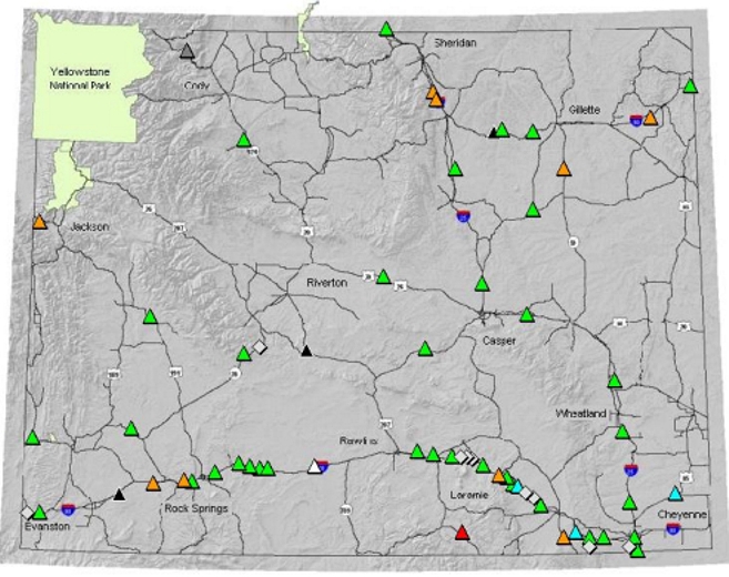
Source: Screenshot of ScanWeb Map Image
Figure 3 – RWIS locations statewide
RWIS No. |
SITENAME |
Highway |
MILEPOST |
|---|---|---|---|
1 |
Wyo Hill |
I - 25 |
3.52 |
2 |
Whitaker |
I - 25 |
30.2 |
3 |
Bordeaux Interchange |
I - 25 |
70.8 |
4 |
Coleman |
I - 25 |
98.7 |
5 |
Deer Creek |
I - 25 |
164.2 |
6 |
Twenty Mile Hill |
I - 25 |
207.2 |
7 |
I-25 Divide |
I - 25 |
267.3 |
8 |
Evanston |
I - 80 |
4.2 |
9 |
First Divide |
I - 80 |
13.86 |
10 |
Church Butte |
I - 80 |
52.65 |
11 |
Peru Hill |
I - 80 |
82.31 |
12 |
Green River Tunnel East |
I - 80 |
90.5 |
13 |
Rock Springs West |
I - 80 |
97.9 |
14 |
Baxter Road |
I - 80 |
111.5 |
15 |
Superior |
I - 80 |
124.5 |
16 |
Point of Rocks |
I - 80 |
129.8 |
17 |
Bitter Creek |
I - 80 |
141.83 |
18 |
Tipton |
I - 80 |
156.72 |
19 |
Continental Divide |
I - 80 |
184.3 |
20 |
Sinclair |
I - 80 |
221.7 |
21 |
Walcott Junction |
I - 80 |
234.66 |
22 |
Dana Ridge |
I - 80 |
244.8 |
23 |
Mile Marker 249.1 |
I - 80 |
249.1 |
24 |
Halleck Ridge |
I - 80 |
252.16 |
25 |
Elk Mountain |
I - 80 |
256.17 |
26 |
County Road 402 |
I - 80 |
262 |
27 |
Wagonhound |
I - 80 |
266.58 |
28 |
Foote Creek |
I - 80 |
269.5 |
29 |
Arlington |
I - 80 |
271.8 |
30 |
Arlington East |
I - 80 |
273.85 |
31 |
Cooper Cove |
I - 80 |
279.36 |
32 |
Strouss Hill |
I - 80 |
283.75 |
33 |
Quealy Dome |
I - 80 |
289.5 |
34 |
Herrick Lane |
I - 80 |
297.66 |
35 |
Summit East |
I - 80 |
325.8 |
36 |
Vedauwoo |
I - 80 |
329.4 |
37 |
Vedauwoo |
I - 80 |
329.4 |
38 |
Remount |
I - 80 |
340.5 |
39 |
Montana Line |
I - 90 |
0.1 |
40 |
Piney Creek North |
I - 90 |
43.7 |
41 |
Piney Creek Interchange |
I - 90 |
44.7 |
42 |
Indian Creek Rd |
I - 90 |
83.3 |
43 |
Dead Horse |
I - 90 |
91.5 |
44 |
Mile Marker 108 |
I - 90 |
108 |
45 |
Inyan Kara |
I - 90 |
170.5 |
46 |
Beulah Interchange |
I - 90 |
205.9 |
47 |
Rim |
US - 191 |
127 |
48 |
Hiland |
US - 20/26 |
57.4 |
49 |
Pumpkin Vine |
US - 287 |
420.4 |
50 |
Beaver Rim |
US - 287 / WY 789 |
48.1 |
51 |
Sage Junction |
US - 30 |
34 |
52 |
Gun Barrel |
US - 85 |
46.8 |
53 |
Meeteetse Rim |
WY - 120 |
61.5 |
54 |
Teton Pass |
WY - 22 |
11.2 |
55 |
Pathfinder |
WY - 220 |
80.1 |
56 |
Skyline |
WY - 230 |
113.2 |
57 |
South Pass |
WY - 28 |
41.4 |
58 |
Red Canyon |
WY - 28 |
59.5 |
59 |
Chief Joseph |
WY - 296 |
32.96 |
60 |
Shute Creek |
WY - 372 |
36 |
61 |
Pine Tree Junction |
WY - 387 |
131.79 |
62 |
Belle Fourche |
WY - 59 |
87 |
The VSL corridor is the first of its kind in Wyoming. It consists of a 52-mile stretch of Interstate 80 from Walcott Junction (20 miles east of Rawlins) to Quealy Dome Interchange (17 miles west of Laramie). In that 52-mile corridor, WYDOT now has 13 RWIS stations. This project represents the first corridor-level RWIS deployment in WYDOT’s history.
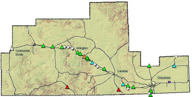
Source: Screenshot of ScanWeb Map Image
Figure 4 – RWIS in southeast Wyoming
RWIS maintenance statewide is primarily conducted by WYDOT forces with the exception of an annual maintenance contract to assist WYDOT forces with the annual preventive maintenance. Annual maintenance costs for WYDOT RWIS are estimated at about $4,000 per site for WYDOT.
2.2 Maintenance Decision Support System
Over the past several years, WYDOT has participated in the FHWA pooled-fund study to deploy a maintenance decision support system (MDSS). That product is currently being used by WYDOT as provided by Meridian Environmental Technologies. The extent to which it is used within the TMC has been somewhat limited, but is beginning to emerge as a useful tool for the TMC operators in road weather condition status and forecasting.
There is no formal guideline in place for using MDSS in WYDOT’s day-to-day operations. Several maintenance crews use the system. However, there is no coordinated effort within WYDOT for how best to use this tool either within the TMC or between the TMC and maintenance. The TMC intends to put this system to better use in the future. Figure 5 below is an image of the MDSS graphical user interface.
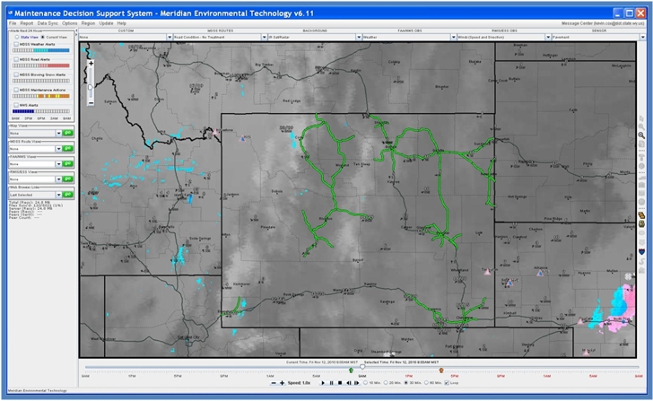
Source: Screenshot of MDSS, Meridian Environmental Technology
Figure 5 – MDSS User Interface
2.3 Alert Notifications
Another product of the MDSS system is known as METalert. It provides current and forecast weather alerts based on individual user-defined thresholds for counties, cities, or individual RWIS stations. WYDOT has just deployed this system, and made it available to TMC operators and maintenance personnel. Below is a screen shot from the application showing the types of alert notifications available.
The alerting system provides for either e-mail or text message notifications, and has quite a few variables for criteria threshold selection. However, the limitation of this system is that it doesn’t provide pop-up alerts on the TMC operators’ computer screens.
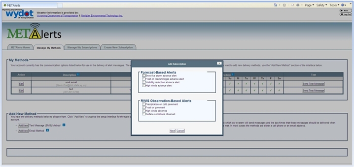
Source: Screenshot of WYDOT METAlerts System
Figure 6 – Weather Alerting System
In the past, WYDOT had used SCAN Sentry alerting system which is part of the overall SCAN Web RWIS management package used to monitor WYDOT’s RWIS. There has not been much success in implementing that into the TMC due to configuration issues with setting reasonable thresholds. The complaint from the TMC operators has been that it sends repetitive alerts for the same condition. Further investigation will be conducted to see if appropriate parameters can be established for that alerting system.
2.4 NorthWest Weathernet
NorthWest Weathernet is the forecasting service WYDOT maintenance forces have used for several years. The service consists of a text-based twice daily forecast hosted on a website. It provides forecasts based on WYDOT’s maintenance shop locations. This format has proven to be very useful for the maintenance foremen and plow operators because they can easily scroll down to their shop location, and get an up-to-date forecast for their area. The format has proven to be more cumbersome from the TMC’s statewide or even sometimes district-wide perspective.
Below is a sample screen shot of the product provided by NorthWest Weathernet, Inc.
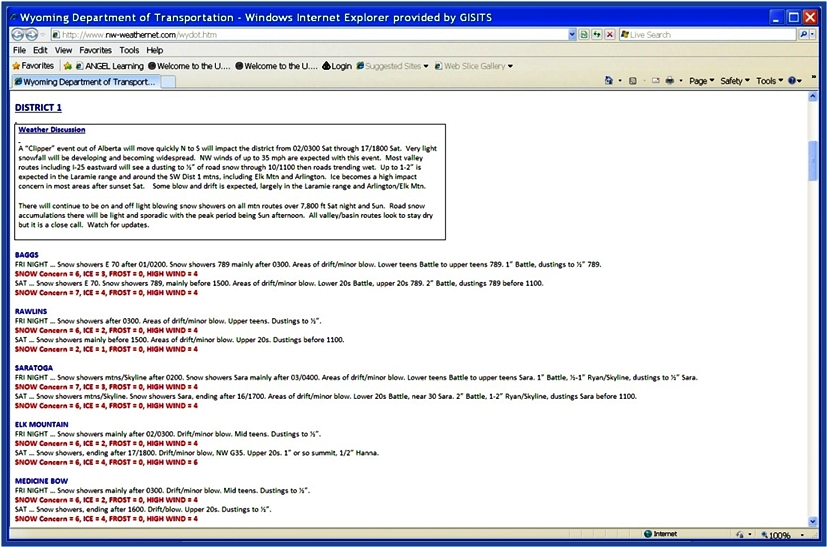
Source: Screenshot of WYDOT NorthWest Weathernet
Figure 7 – NorthWest Weathernet WYDOT page
2.5 Other TMC Weather Resources
Numerous other sources of weather information are currently being used within the TMC. Most of these are in the form of websites such as Intellicast, the Weather Channel, or the National Weather Service. Additionally, there is a television in the TMC which is oftentimes tuned to the Weather Channel, or a national or local news channel which occasionally show weather information.
3 Concepts of Operations
In terms of operational concepts for using weather within the TMC, very few formal guidelines or written policies exist. There are some established thresholds from RWIS stations that require action in terms of notifying maintenance or the public of conditions.
Conceptually, the TMC attempts to manage weather at two levels, statewide and/or corridor.
3.1 Statewide Weather Management
The TMC is the only entity at WYDOT that attempts to, or has the responsibility to manage weather from a statewide perspective. Although there are many weather information resources, no single group or person within the TMC is tasked with managing weather information and providing a strategy to handle it statewide. In effect, the TMC still has a WYDOT legacy tendency to operate as five separate maintenance districts. However, the TMC offers WYDOT’s best promise for strategic management of weather events.
3.2 Laramie to Cheyenne (The Summit) Commuter Corridor
This corridor along Interstate 80 was WYDOT’s first corridor-level deployment of ITS equipment back in 2003. Additional equipment has been deployed in this corridor since 2003. Today, the ITS equipment in this 20-mile stretch includes: six cameras, ten dynamic message signs, three RWIS stations, and twelve speed sensors. With the density of DMS signs in this corridor, the TMC is able to provide traveler information in a slightly different manner. Essentially, information can be provided in a more location-specific manner as to road and weather conditions. The treacherous nature of this corridor has made it a candidate for one of the next three VSL corridors in the state.
3.3 Variable Speed Limit Corridor
WYDOT’s first VSL corridor is a 52-mile stretch of Interstate 80 located in the south central part of the state between the towns of Rawlins and Laramie. The VSL signs for the corridor became operational February 13th, 2009. In their first 14 months of use, they have proven to offer some very positive results in terms of number and severity of accidents, and number and length of closures.
The corridor consists of 14 VSL locations (seven in each direction). Vehicle speeds are monitored by side-fire radar detectors at 18 locations, and central control software provides average speeds for all vehicles every 30 seconds. The speeds are displayed on a map using color-coded icons and highway segments that change color based on the average observed speeds. Additionally, 13 RWIS sensors provide real-time weather information, including surface status, visibility, wind, humidity, air temperature and surface temperature.
3.3.1 Current Policy/Procedure
The current policy for posting speed limits was developed in a cooperative effort amongst the TMC, Highway Patrol, and the District Maintenance personnel. The policy is lengthy, and describes the procedures for posting speeds based on the situation, and the personnel available at the time of posting a speed limit change.
The policy does allow TMC operators to reduce the speed based on a sustained speed reduction of at least 10 MPH for at least 15 minutes. The TMC operators primarily use speed data to make this decision, but also refer to RWIS data as supporting information.
3.3.2 Draft Control Strategy
WYDOT’s ITS Program is currently working with the University of Wyoming’s Civil Engineering Department to come up with a control strategy that would automate, and make better use of the speed and weather data to provide TMC operators with a quality recommended speed based on the information available from these sensors. The control strategy is in its early phases of development, and the draft version will begin to be tested this Fall.
4 Integration Needs
After completing the self-evaluation “interview” process, 11 high priority needs were identified as shown in Table 2 below. There were also seven medium priority needs, and two low priority needs. As the group evaluated the needs and their levels, it became apparent that by addressing the high priority needs, most of the medium and low priority needs would be addressed. (See Appendix D.)
The sections below describe the 11 high priority needs, and group them into four main “need” areas.
Need Areas |
Definition of Need |
|---|---|
Advisory Operations |
|
Weather Information Dissemination |
Disseminate weather information to a larger set of stakeholders and users in the region (including transit and other modes) |
Institutional Coordination |
|
Written Policy Development |
Develop and implement clear, written policies and procedures for handling weather events. |
Coordination within TMC |
Improve coordination within the TMC |
Coordination with Adjacent Jurisdictions |
More coordinated responses and information with adjacent jurisdictions/regions |
Treatment Operations |
|
Level of Service Restoration |
Reduce the time required to restore pre-event level of service operations after a weather event |
Weather Management Response |
Improve the timeliness of weather management response including deployment of field personnel and equipment |
Weather Information Processing and Gathering |
|
Interpreting Weather Information |
Assistance in interpreting weather information and how best to adjust operations in light of that information. |
Improving Weather Information Coverage |
Improve the coverage and granularity of weather information in the region. |
Better Real-Time Information On Road Conditions |
Better real-time information on road conditions during weather events. |
Better Prediction of Weather Event Impacts |
Better prediction of impact of weather events including assessment of reduction in capacity. |
Better Short-Term Forecasts |
Better short-term forecasts of arrival time, duration, and intensity of specific weather events at specific locations. |
5 Integration Solutions
The “Levels of Integration” matrix (see Figure 8) shows where WYDOT’s TMC is today (highlighted in yellow), and where it needs to be following integration (highlighted in pink). This matrix represents recommendations directly from the Self-Evaluation Guide.
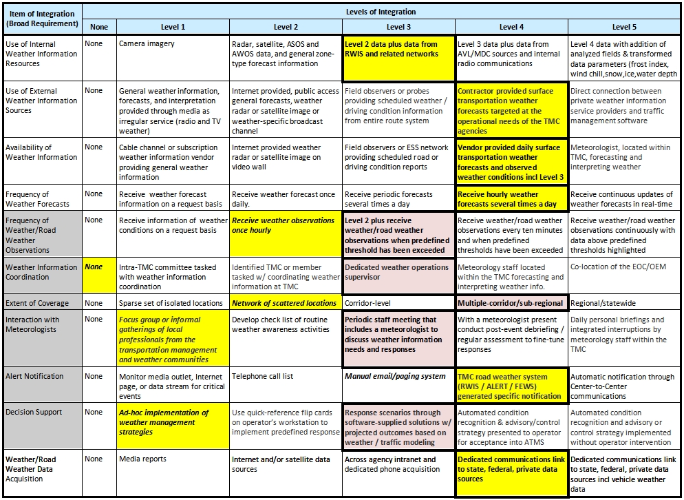
Figure 8 – Integration Levels Matrix
The six items of integration shown in gray are the six broad areas where WYDOT’s TMC needs to improve from its current level of integration to a proposed level of integration in order to effectively integrate weather into its operations. The sections below give more detail on each of these integration areas, and offer proposed solutions on how that integration might be accomplished.
5.1 Frequency of Road Weather Observations
This integration item can best be addressed by expanding the frequency of real-time reports from individuals traveling on Wyoming highways, including, but not limited to plow drivers, the commercial trucking community, and other members of the traveling public.
Presently, snow plow operators call the TMC when either conditions change, or two hours have passed. The TMC could benefit from the implementation of a system that notifies when each currently active plow has passed the two-hour report timeframe.
Additional reporting could come from other travelers on WYDOT’s highways, assuming that they have been properly trained to identify conditions, and how to pass that information to the TMC.
5.2 Weather Information Coordination
As can be seen from the levels of integrations matrix, this item of integration has the biggest gap in terms of where WYDOT currently is (highlighted in yellow), and where WYDOT would ultimately like to be in terms of TMC weather integration. Consequently, most of the initial implementation efforts of this plan will focus in this broad area of weather information coordination.
WYDOT plans to at least partially address this need immediately by contracting with a part-time local meteorologist (DayWeather, Inc.) to perform weather information management tasks in the TMC. This initial contract began in early December 2010 and will extend for a trial period through May 31st, 2011.
5.3 Extent of Coverage
Until this past year, WYDOT had a scattered network of approximately 32 RWIS stations throughout the state. With the implementation of the first VSL project, WYDOT found it necessary to increase the coverage of real-time weather information, and implemented its first corridor-level RWIS deployment, installing 13 RWIS in a 52-mile stretch of interstate.
This deployment is likely the beginning of many more of its kind in Wyoming. Presently, there are three more VSL projects in the design phase for WYDOT, and one currently under construction.
The TMC is struggling to manage this corridor-level information, and needs to improve its ability to effectively use this more granular information to identify problems, and help establish appropriate speed limits.
5.4 Interaction with Meteorologists
The TMC currently has two very good resources that allow for direct communication with a meteorologist. The first is provided by a direct telephone number to a staff meteorologist at NorthWest Weathernet, Inc., and the second is either by phone or radio to the National Weather Service meteorologist located in Cheyenne. Both of these resources are currently under-utilized by the TMC. With the addition of a Weather Information Manager on the floor of the TMC, coordination with these resources should improve greatly.
5.5 Alert Notifications
Although WYDOT is presently at integration level 4 on this item, work still remains to enhance our current MetAlert system. Work also remains to attempt redeployment of SCAN Sentry on the TMC operator workstations. Lastly, WYDOT is also going to pursue the development of its own weather information tool that can be tailored to include current and forecast road weather conditions. Part of that tool will include a system to provide alert notifications.
5.6 Decision Support
Two of the biggest decisions TMC operators face on a minute-by-minute basis are determining appropriate DMS messaging and VSL speed postings. Through the use of weather and traffic information, a decision model integrated into WYDOT’s advance traffic management system (ATMS) could prove to be an effective means of providing timely, accurate, and consistent messaging and posted speeds on WYDOT’s DMS and VSL, respectively.
6 Implementation of Integration Plan
6.1 Summary of Integration Strategies
Shown below (Table 3) is a summary of WYDOT’s integration strategies. The table shows WYDOT’s current level for each integration item, the recommendation from the self-evaluation guide, the integration level selected by WYDOT for both the current (C) timeframe, and future (F) timeframe, and comments for each integration item.
Integration Item |
Current Integration Level |
Guide Recommended Integration Level |
Chosen Weather Integration Level(C/F)* |
Rationale/Comments |
|---|---|---|---|---|
1: Use of Internal Weather Information Resources |
3 |
3 |
3/4 |
C=expand RWIS locations; F=outfit & receive data from plows & other vehicles |
2: Use of External Weather Information Resources |
4 |
4 |
4/4 |
Build integrated weather information tool to assist TMC operators |
3: Availability of Weather Information |
4 |
4 |
4/4 |
Availability meets current needs |
4: Frequency of Weather Forecasts |
4 |
4 |
4/4 |
Frequency meets current needs |
5: Frequency of Weather/Road Weather Observations |
2 |
3 |
3/3 |
Expand coverage and frequency of plow driver reports |
6: Weather Information Coordination |
None |
3 |
3/3 |
Contracting with a part-time local meteorologist to perform weather information management tasks in TMC. |
7: Extent of Coverage |
2 |
4 |
4/5 |
C=Adding four more VSL corridors throughout the state; F=continued expansion of RWIS sites. |
8: Interaction with Meteorologists |
1 |
3 |
4/5 |
See item 6 above. |
9: Alert Notification |
4 |
4 |
4/4 |
Enhance alert notification in phases (use |
10: Decision Support |
1 |
3 |
3/4 |
C=automated recommendations for VSL system; F=expand to DMS recommendations. |
11: Weather and Road Weather Data Acquisition |
4 |
4 |
4/5 |
C=continue current acquisition; F=automated data collection from DOT vehicles. |
* C/F=Current plans (within next 1-2 years)/Future plans (beyond 2 years)
6.2 Implementation Tasks
The integration strategies can be grouped into the following seven implementation tasks or projects:
- RWIS Expansion - Expand RWIS coverage throughout state, and multiple corridor RWIS projects. We will start by doing a gap analysis, and seek input from District Maintenance offices to determine desired locations. With that, WYDOT can develop an RWIS expansion plan, and budget for new RWIS on an annual basis to complete the desired expansion in approximately the next five years.
- AVL/MDC - Expand vehicle weather data transmission to TMC from plows with AVL/MDC. This will include continued deployment of our current AVL system statewide. For the MDC component, WYDOT will use its systems engineering process to ensure all requirements are met, including integration with the current AVL system.
- Weather Information Manager (WIM) - Employ part time, contracted meteorologist as weather information manager. This individual will help implement much of this plan, assist the TMC operators in managing and utilizing current and future weather information, and provide a primary point of contact for all weather information resources within WYDOT.
- VSL Expansion - Add VSL in four locations and continue to expand in statewide corridors. One of these four new corridors is currently under construction and scheduled to be complete by January 2011. Two more of these four will be operational by October 2011, and the fourth corridor is currently schedule to be constructed in 2012.
- Weather Information Tool - Build integrated weather information tool to assist operators. Deploy portions of this for commercial vehicle and general public use. The weather information manager will be instrumental in developing this system. They will also be the one responsible for keeping the information in this tool timely and accurate.
- Weather Alert Notification - Expand/enhance alert notification system in phases: 1) using SCAN Sentry 2) expanding METalert system 3) using the new integrated weather integration tool/database. SCAN Sentry is presently available to the TMC, it just needs some fine tuning on the configuration and some additional training for the operators. METalert is also available, but additional features (e.g. visibility alerts) could be very useful for the TMC operators.
- ATMS Decision Support - Expand decision support tools, starting with VSL and moving to DMS recommendations. This will include some software development work for our existing ATMS to provide such recommendations based on weather and traffic information.
6.3 Integration Timeline and Cost Estimates
The table below shows the seven projects identified in the previous section, an estimated start time and end time for each, an estimated implementation cost, and an estimated operations and maintenance cost.
| Project | Start | Completion | Initial Cost | O&M Cost |
|---|---|---|---|---|
| RWIS Expansion | Ongoing | 2015 | $ 2,000,000 | $ 400,000/year |
| AVL/MDC | 2011 | 2017 | $ 800,000 | $ 100,000/year |
| WIM | Ongoing | N/A | N/A | $ 100,000/year |
| VSL Expansion | Ongoing | 2014 | $ 3,000,000 | $ 200,000/year |
| Wx Info Tool | 2011 | 2013 | $300,000 | $15,000/year |
| Wx Alert Notification | Ongoing | 2013 | $20,000 | $3,000/year |
| ATMS Decision Support | 2011 | 2013 | $150,000 | $15,000/year |
The good news is that most of these projects are underway and at least partially funded. At this point, the scopes of these projects may need to be slightly re-defined to meet the needs identified in this plan.
6.4 Anticipated Challenges and Constraints
As shown in Table 4 above, four of the seven projects are already ongoing, and reasonably funded. The AVL project is also underway, but there is no clear direction yet on the mobile data computer (MDC) aspect of that project. Integrating an MDC with the AVL system WYDOT is currently in the process of deploying could prove to be challenging.
The weather information tool will be a fairly challenging undertaking, but many of the components are already in-place to facilitate some of that system. Again, integration of multiple information resources will be the challenge with this project.
Lastly, WYDOT currently has an off-the-shelf ATMS. Tailoring this system to meet the needs of our VSL and DMS decision support could prove to be a difficult task. This software is provided by a third party vendor and their ability to tailor the software to the TMC’s needs remains an unknown at this point.
Appendix A – Summary Report of Weather Events
Weather Event |
Frequency |
Extent |
Impact |
|---|---|---|---|
Tornadoes |
Seldom |
Local/Isolated Spots |
Significant Impact |
Blowing Sand or Dust |
Occasional |
Areawide |
Significant Impact |
Flooding |
Occasional |
Statewide |
Significant Impact |
Sleet, and Freezing Rain |
Occasional |
Areawide |
Significant Impact |
Blizzard or White-out |
Regular |
Statewide |
Significant Impact |
Blowing Snow |
Regular |
Statewide |
Significant Impact |
Bridge Frost, Road Frost |
Regular |
Statewide |
Significant Impact |
Drizzle and Light Rain |
Regular |
Statewide |
Little Impact |
Flurries and Light Snow |
Regular |
Statewide |
Little Impact |
High Winds |
Regular |
Regional |
Significant Impact |
Moderate to Heavy Rain |
Regular |
Statewide |
Little Impact |
Moderate to Heavy Snow |
Regular |
Statewide |
Moderate Impact |
Severe Thunderstorms |
Regular |
Regional |
Significant Impact |
Smoke, Mist, Fog, Smog or Haze |
Regular |
Regional |
Significant Impact |
Appendix B – Summary Report of Impacts Due to Weather Events
Summary report of impacts due to your weather events (Section 2 Report)
Weather often impacts the activities of transportation system operators working to maintain safety and mobility. Making sense of weather information along with recognizing the benefits of its application beyond the simplest case is not a trivial task. As a generalization, TMC operators tend to be more responsive and take action based on their observations of traffic impacts rather than responding directly to weather information. It is important to understand the nature of weather impacts on capacity and speed reductions, impacts on safety (e.g., crash risk/frequency, incident management including Safety Service Patrols that are often dispatched from or coordinated with TMCs), and impacts on institutional coordination (i.e., need for communication between traffic managers and maintenance personnel, traffic managers and emergency management personnel, traffic managers and law enforcement personnel) to ensure that the self-evaluation and the integration solutions address the right concerns. The ability to estimate impacts could presumably lead to managing freeway systems and arterial signal systems using advisory, control and treatment strategies efficiently.
This report identifies the impacts of these weather events on your TMC’s traffic operations considering both impacts to users as well as operators.
Weather Event |
Increased |
Increased |
Reduced |
Traffic Management |
Disruption of CVO or |
Road Closures |
|---|---|---|---|---|---|---|
Drizzle and Light Rain |
||||||
Moderate to Heavy Rain |
||||||
Severe Thunderstorms |
||||||
Flooding |
||||||
Flurries and Light Snow |
||||||
Moderate to Heavy Snow |
||||||
Blizzard or White-out |
||||||
Sleet, and Freezing Rain |
||||||
High Winds |
||||||
Blowing Snow |
||||||
Blowing Sand or Dust |
||||||
Smoke, Mist, Fog, Smog or Haze |
||||||
Tornadoes |
||||||
Bridge Frost, Road Frost |
Weather Event |
Slick Roads |
Road Obstruction |
Structural Deterioration |
Present of Debris |
Low Visibility |
Others (Please Specify) |
|---|---|---|---|---|---|---|
Drizzle and Light Rain |
||||||
Moderate to Heavy Rain |
||||||
Severe Thunderstorms |
||||||
Flooding |
||||||
Flurries and Light Snow |
||||||
Moderate to Heavy Snow |
||||||
Blizzard or White-out |
||||||
Sleet, and Freezing Rain |
||||||
High Winds |
||||||
Blowing Snow |
||||||
Blowing Sand or Dust |
||||||
Smoke, Mist, Fog, Smog or Haze |
||||||
Tornadoes |
||||||
Bridge Frost, Road Frost |
Weather Event |
Increased use of equipment and labor |
Increased in-house labor |
Increased contractor labor |
Loss of |
Changes in traffic control operations |
Others |
|---|---|---|---|---|---|---|
Drizzle and Light Rain |
1 | 1 | 1 | 1 | 1 | |
Moderate to Heavy Rain |
2 | 2 | 1 | 1 | 2 | |
Severe Thunderstorms |
3 | 2 | 1 | 3 | 3 | |
Flooding |
2 | 2 | 1 | 1 | 2 | |
Flurries and Light Snow |
2 | 2 | 1 | 1 | 2 | |
Moderate to Heavy Snow |
3 | 3 | 1 | 2 | 3 | |
Blizzard or White-out |
4 | 4 | 1 | 2 | 4 | |
Sleet, and Freezing Rain |
3 | 3 | 1 | 2 | 2 | |
High Winds |
3 | 2 | 1 | 2 | 3 | |
Blowing Snow |
4 | 4 | 1 | 2 | 4 | |
Blowing Sand or Dust |
2 | 1 | 1 | 1 | 2 | |
Smoke, Mist, Fog, Smog or Haze |
3 | 3 | 1 | 1 | 3 | |
Tornadoes |
2 | 1 | 1 | 3 | 2 | |
Bridge Frost, Road Frost |
2 | 1 | 1 | 1 | 3 |
Appendix C – Summary Report on Current Integration Level
| Item of Integration: I1 Use of Internal Weather Information Resources | |||||
|---|---|---|---|---|---|
None |
Camera imagery |
Radar, satellite, ASOS and AWOS data, and general zone-type forcast information |
Level 2 data plus data from RWIS and related networks |
Level 3 data plus data from AVL/MDC sources and internal radio communications |
Level 4 data with addition of analyzed fields and trandformed data parameters (frost index, wind chill, est. snow, ice, water depth) |
| Item of Integration: I2 Use of External Weather Information Resources | |||||
None |
General weather information, forecsts, and interpretation provided through media as irregular service (radio and TV weather) |
Internet provided, public access general forecasts, weather radar or satellite image or weather-specific broadcast channel |
Field observers or probes providing scheduled weather/driving condition information from entire route system |
Contractor provided surface transportation weather forecasts targeted at the operational needs of the TMC agencies |
Direct connection between private weather information service providers and trffic management software |
| Item of Integration: I3 Availability of Weather Information | |||||
None |
Cable channel or subscription weather information vendor providing general weather information |
Internet provided weather radar or satellite image on video wall or computer screen |
Field observers or ESS network providing scheduled road or driving condition reports |
Vendor provided daily surface transportation weather forecasts and observed weather conditions including level 3 |
Meteorologist, located within TMC, forecasting and interpreting weather |
| Item of Integration: I4 Frequency of Weather Forecasts | |||||
None |
Receive information of weather forecasts on a request basis |
Receive weather forecast once daily |
Receive periodic forecasts several times a day |
Receive hourly updates of weather forecasts several times a day |
Receive continuous updates of weather forecasts in real-time |
| Item of Integration: I5 Frequency of Weather/Road Weather | |||||
None |
Receive information of weather conditions on a request basis |
Receive weather observations once hourly |
Level 2 plus receive weather/road weather observations when predefined thresholds have been exceeded |
Receive weather/road weather observations every ten minutes and when predefined thresholds have been exceeded |
Receive weather/road weather observations coninuously with data above predefined thresholds highlighted |
| Item of Integration: I6 Weather Information Coordination | |||||
None |
Intr-TMC committee tasked with weather information coordination |
Identified TMC or maintenance staff member tasked with coordinating weather information at TMC or virtually linked to the TMC |
Dedicated weather operations supervisor |
Meteorology staff located within the TMC forecasting and interpreting weather information |
Co-location of the EOC/OEM |
| Item of Integration: I7 Extent of Coverage | |||||
None |
Sparse Set of Isolated Locations |
Network of Scattered Locations |
Corridor-level |
Multiple-corridor/sub-regional |
Regional/Statewide |
| Item of Integration: I8 Interaction with Meteorologists | |||||
None |
Focus group or informal gatherings of local professinals from the transportation management and weather communities |
Develop check list of routine weather awareness activities |
Periodic staff meetng that includes a meteorologist to discuss weather information needs and responses |
With a meteorologis present conduct post-event debriefing/regular assessment to fine-tune responses |
Daily personal briefings and integrated interruptions by meteorology staff within the TMC |
| Item of Integration: I9 Alert Notification | |||||
None |
Monitor media outlet, Internet page, or data stream for critical events |
Telephone call list |
Manual email/paging system |
TMC road weather system (RWIS/ALERT/FEWS) generated specific notifications (Email or page) |
Automatic notification through Center-to-Center communications |
| Item of Integration: II10 Decision Support | |||||
None |
Ad-hoc implementation of weather management strategies |
Use quick-reference flip cards on operator's workstation to implement predefined response |
Response scenarios through software supply potential solutions with projected outcomes based on weather/traffic modeling |
Automated condition recognition and advisory or control strategy presented to operator for acceptance into ATMS |
Automated condition recognition and advisory or control strategy implemented without operator intervention |
| Item of Integration: II11 Weather/Road Weather Data Acquisition | |||||
None |
Media Reports |
Internet and/or Satellite Data Sources |
Across agency intranet and dedicated phone acquisition |
Dedicated communications link to state, federal, private data sources |
Dedicated communications link to state, federal, private data sources including vehicle-derived weather data |
Appendix D – Summary Report on TMC Operational Needs to Be Addressed by Better Weather Integration
Need Area |
Rating |
Need Statement |
|---|---|---|
Advisory Operations |
3-High |
Disseminate weather information to a larger set of stakeholders and users in the region (including transit and other modes) |
2-Medium |
Improve targeting of weather messages (site-specific; user group specific) to more effectively convey road weather information. |
|
2-Medium |
Provide better pre-trip weather condition information to aid travelers in their decision-making |
|
2-Medium |
Provide better en-route information on weather conditions to aid travelers in their decision-making |
|
2-Medium |
Improve message content (for DMS, 511, HAR, Web sites, etc.) Institutional Coordination |
|
3-High |
Develop and implement clear, written policies and procedures for handling weather events. |
|
3-High |
Improve coordination within the TMC |
|
3-High |
More coordinated responses and information with adjacent jurisdictions/regions |
|
2-Medium |
Improve coordination with local public safety and emergency agencies |
|
1-Low |
More opportunities and mechanisms for communications and exchange with others in the weather community and those with experience dealing with weather events. |
|
Traffic Control Operations |
2-Medium |
Improve management of emergency routing and evacuation for large-scale weather events. |
2-Medium |
Improve traffic diversion and alternate routing capabilities |
|
0-No Need |
Improve traffic signal timing during weather events to facilitate traffic movement |
|
0-No Need |
Improve safety at intersections during weather events |
|
Treatment Operations |
3-High |
Reduce the time required to restore pre-event level of service operations after a weather event |
3-High |
Improve the timeliness of weather management response including deployment of field personnel and equipment |
|
2-Medium |
Reduce costs of roadway treatment options |
|
1-Low |
Need to assist maintenance in determining the optimal treatment materials, application rates, and timing of treatments. |
|
Weather Information Processing and Gathering |
3-High |
Assistance in interpreting weather information and how best to adjust operations in light of that information. |
3-High |
Improve the coverage and granularity of weather information in the region |
|
3-High |
Better real-time information on road conditions during weather events |
|
3-High |
Better prediction of impact of weather events including assessment of reductions in capacity |
|
3-High |
Better short-term forecasts of arrival time, duration, and intensity of specific weather events at specific locations |