
COLORADO SPRINGS
TRAFFIC MANAGEMENT CENTER
WEATHER INTEGRATION PLAN
January 11, 2010
GLOSSARY OF ABBREVIATIONS
ASOS |
Automated Surface Observing System |
AVL |
Automatic Vehicle Location |
AWOS |
Automated Weather Observing System |
CAD |
Computer Aided Dispatch |
CCTV |
Closed-circuit TV |
CDOT |
Colorado Department of Transportation |
CSP |
Colorado State Patrol |
CSPD |
Colorado Springs Police Department |
CSTMC |
Colorado Springs Traffic Management Center |
CTMC |
Colorado (statewide) Transportation Management Center |
EOC |
Emergency Operation Center |
ESS |
Environmental Sensor Stations |
FHWA |
Federal Highway Administration |
ITS |
Intelligent Transportation Systems |
MDC |
Mobile Data Computer |
NOAA |
National Oceanic and Atmospheric Administration |
RWIS |
Road Weather Information System |
RWMP |
Road Weather Management Program |
SWAS |
Severe Weather Alert System |
TCS |
Traffic Control System |
TMC |
Traffic Management Center |
VMS |
Variable Message Sign |
TABLE OF CONTENTS
- Glossary of Abbreviations
- 1. Introduction
- 2 CSTMC Weather Integration Plan
- 2.1 Inventory Existing Weather and Transportation Systems
- 2.2 Concept of Operation
- 2.3 Integration Needs
- 2.4 Integration Solutions
- 2.4.1 Use of Internal Weather Information Resources
- 2.4.2 Use of External Weather Information Resources
- 2.4.3 Availability of Weather Information
- 2.4.4 Frequency of Weather Forecasts
- 2.4.5 Frequency of Road Weather Observations
- 2.4.6 Weather Information Coordination
- 2.4.7 Extent of Coverage
- 2.4.8 Interaction with Meteorologist
- 2.4.9 Alert Notification
- 2.4.10 Decision Support
- 2.4.11 Weather/Road Weather Data Acquisition
- 3 Implementation of Integration Plan
LIST OF TABLES
- Table 2-1 CSTMC Operational Needs
- Table 2-2 Weather Impacts on Colorado Springs Roadways and Traffic Operations
- Table 2-3 Current, Recommended and Selected Weather Integration Strategies
- Table 2-4 Levels of Integration
- Table 2-5 Five Dimensions of Integration
- Table 3-1 Implementation Tasks and Time Frames
LIST OF FIGURES
1. INTRODUCTION
1.1 Background
The Federal Highway Administration’s (FHWA) Road Weather Management Program (RWMP) was introduced to the Colorado Springs Traffic Management Center (CSTMC) in the spring of 2009. The program intent is to help reduce adverse impacts of weather on the transportation system by assisting agencies in integrating weather information into their daily Traffic Management Center (TMC) operation. For this to be an effective goal, the CSTMC had to evaluate its needs for weather integration and develop a plan to implement strategies to meet those needs. CSTMC used the Integration of Weather Information in Transportation Management Center Operations: Self-Evaluation and Planning Guide developed by FHWA to identify the relevant weather events in the Pikes Peak region of Colorado and determine the type and magnitude of impacts those events have on the region’s transportation system and on the operations and traffic management responsibilities. The tool also helped identify current strategies for managing the impacts of weather, prioritize the identified needs for weather information application and integration, and identify integration strategies and solutions that are best suited to meeting the CSTMC’s high priority needs.
1.2 Purpose and Benefit
The CSTMC was selected by the FHWA to assist in the testing and improvement of a working draft of the Integration of Weather Information in Transportation Management Center Operations: Self-Evaluation and Planning Guide. The Guide was prepared in Microsoft Access and takes the user through several sections that yield potential weather integration strategies for the TMC. The CSTMC was asked to provide feedback to assist in the improvement of the Guide in addition to developing a weather integration plan.
The Guide was used to develop a set of weather integration strategies for the CSTMC. The CSTMC was selected to participate in the study primarily due to the uniqueness of the center in managing arterial traffic signals throughout the City of Colorado Springs, Colorado.
The CSTMC has mostly been reactive when dealing with both traveler information and traffic signal operations as a result of severe weather that impacts the region. Weather integration should allow the CSTMC to become more proactive with some functions, primarily in traffic signal timing. After working with the Guide and after meeting with the Battelle team, it was decided to focus on identifying weather information requirements for modified signal timing for adverse weather and to further explore strategies for implementing a modified signal timing plan.
1.3 TMC Overview
The CSTMC is very unique compared to the other centers in Colorado. It is a regional facility that covers the Pikes Peak region in El Paso County, Colorado. The center is run and operated by the City of Colorado Springs Traffic Engineering Division instead of by the Colorado Department of Transportation (CDOT). The CSTMC facility houses the Intelligent Transportation System (ITS) equipment and personnel. The ITS equipment includes the signal timing equipment and the computer systems to operate the traffic cameras and Variable Message Signs (VMS). It is also the facility where all CSTMC fiber communications are managed. Some of the factual data for the center and the Pikes Peak region include:
- CSTMC incorporates the management and oversight of nearly 564 traffic signals in Colorado Springs.
- The center is open Monday through Friday from 6:30 am until 6 pm. During those hours the City of Colorado Springs is responsible for managing and controlling all the transportation management devices in the region, including the cameras and variables message signs on the I‑25 Corridor. The after-hours control of the VMS reverts to the Colorado Statewide Transportation Management Center (CTMC). The after-hours traffic signal control is managed by the City of Colorado Springs through an emergency callout procedure. While the CSTMC is open from 6:30 am until 6 pm, the traffic signal technicians work between 7:30 am – 5:30 pm.
- The CSTMC has a total of 63 cameras and 47 VMS. There are 29 cameras and 31 VMS on I-25. The other cameras and VMS are on arterial roadways.
- There are 28 miles of coverage on I-25 in the Pikes Peak region with approximately 100,000 annual average daily traffic including 8% truck traffic.
- The population in the region is approximately 400,000.
- There are 1,300 roadway miles in Colorado Springs.
- The elevation in Colorado Springs ranges from 6,000 to around 7,000 feet. The highest elevation location on I-25 is on Monument Hill at approximately 7,300 feet.
- The City’s Street Division is responsible for servicing over 7,423 lane miles of roadway, extending over a 196 square mile area. The services performed by the Street Division include pavement repairs and maintenance as well as snowfall removal.
- The average annual snowfall is 42 inches.
The CSTMC collects and distributes traffic information. The most common dissemination methods include VMS, Twitter and media releases. The types of traffic information include:
- Traffic Incidents (crashes, stalls, debris, etc.)
- Road Work
- Major Congestion
- Road/Weather Conditions impacting driving
- Highway/Street Closures for Emergency Calls (fire, police, utilities)
- Power/Traffic Signal Outages
- Fires (controlled burns, structure fires, vehicle fires and wildfires)
- Special Events (parades, graduations, races, USAFA events, World Arena Events, etc.)
- Traffic Campaigns in the State (DUI/Seatbelt)
- Accident Alert Status (Cold Reporting) for the Colorado Springs Police Department (CSPD) and Colorado State Patrol (CSP)
- Chain Law Restrictions for Commercial Vehicles for Monument Hill
- AMBER Alerts
The CSTMC is responsible for traffic signal timing and traffic signal coordination. The computerized Traffic Control System (TCS) allows city staff to continually evaluate and coordinate the City's traffic signals. The City Traffic Engineering staff studies and re-evaluates approximately 30 to 40 arterial streets each year for optimal coordination. The goal of traffic signal coordination is to progress the greatest number of vehicles through the system with the fewest stops and shortest amount of delay.
The Traffic Signal Timing Team is comprised of the City's Traffic Engineer and traffic signal technicians who specialize in the timing and coordination of the traffic signals. The Traffic Signal Timing Team gathers data, evaluates, and studies the major and minor arterial streets. They drive the arterial before and after the new coordination timing is applied to determine the effectiveness and efficiency of the new coordination.
Coordinated signals attempt to provide green lights for the major vehicle flow on a street. This requires that City staff gather data on the volume, speed, distance between signals, and the timing of individual intersections. When the data have been collected a study is done to determine the best timing and coordination of all intersections involved. This may require that the timing of the intersections to be adjusted to facilitate the best flow of vehicles.
When the best coordination has been determined the Traffic Signal Timing Team implements the new timing plan. Studies are conducted to evaluate the efficiency and to make necessary adjustments. Coordination throughout the city is continually monitored and is reevaluated as needed.
Each arterial has special coordination needs and may require that various types of special timing plans be implemented to help the flow of traffic. To accommodate heavy travel demand periods, it may be necessary to have a long cycle length, and this may cause delays on the side streets. Some arterials may have a heavier flow in one direction. This movement may be favored, causing more stops in the less traveled direction. Some intersections may have lagging left turn movements. This means the left turn arrow comes on at the end of the green through light. There may also be planned stops on long arterials to help maintain the flow of vehicles.
Effective coordination greatly improves the flow of vehicles on the arterial by minimizing the interruption of traffic flow and reducing air pollutants. Other than placing a traffic signal in recall when video camera detection is iced over, the effects of weather on traffic flow have not been considered when establishing signal timing plans in the past. This weather integration plan will allow the staff to develop strategies for modifying signal timing plans in response to specific weather events.
A variety of weather in the region provides a significant challenge to motorists, highway maintenance and traffic signal crews. It also creates havoc with TMC equipment including the traffic signals detection cameras and the highway cameras. The weather systems effecting travel include winter snow storms, high winds, thunderstorms, street flooding and fog conditions.
The climate is very unique within the 194 square miles of the Colorado Springs City limits. While there is only a slight change in elevation in various parts of the City, the actual weather and road conditions can be drastically different at the same time in various locations in the City limits. The weather conditions in the spring and summer produce high winds, thunderstorms with flooding and lightning strikes and foggy conditions. The fall and winter produce high winds, snow storms with blowing snow, heavy snow and occasional extreme low temperatures and occasional foggy conditions.
Weather forecasting information is available from a variety of sources. The CSTMC operators have no set schedule to check the various sources of information.
1.4 Weather Integration Self-Evaluation Process
A committee of experts from the region met to conduct their self-evaluation based on the Guide and to seek options to utilize integrated weather information in the traffic management process. The committee was comprised of representatives from the CSTMC, Colorado Springs Traffic Engineering, Colorado Springs Street Department, Office of Emergency Management, and Colorado Department of Transportation maintenance.
Most of these representatives only meet as a group during emergency operations such as blizzards in the winter months. This was an excellent full day (6:30 am until 6 pm), opportunity to allow an exchange of operational procedures during a non-crisis situation. The exchange of information helped operational units better understand each other’s weather gathering information and implementation plans based on the weather forecasting information. Both the State of Colorado and City of Colorado Springs highway maintenance have proactive approaches to utilizing the weather information for decision making on plowing streets during winter storms. In the initial meeting it was determined that another source of weather forecasting should be available to assist the TMC with weather information. The Office of Emergency Management receives weather forecast updates daily from Skyview Weather. Skyview Weather is an operational weather company that provides accurate daily forecasts and real time weather information to many clients around the west. These alerts are sent directly to both email and mobile devices. This Skyview Weather report distribution was expanded to include the CSTMC starting in August, 2009. The report is normally received at the CSTMC operator computer by email between 7:30 am and 8 am. While receiving and reviewing the weather forecasts when they arrive, the CSTMC has not initiated any signal timing plans based on winter storm forecasts.
1.5 Relationship to Other Activities and Plan Documents
The CSTMC does not have a regional ITS architecture but instead relies on a CDOT ITS architecture. An architecture is a formalized description of which ITS elements will be deployed, the entities that will deploy them, and how those entities will communicate with the ITS elements and with each other. A Strategic Plan identifies the projects necessary to implement the ITS architecture and determines the relative priorities of those projects. The US Department of Transportation requires that ITS Architectures be developed as a condition for receiving federal funding for ITS projects or for funding of projects that incorporate ITS elements.
The CSTMC does have a plan for incident management response in the Pike Peak region which is a manual and includes detour routes on arterials in the Colorado Springs area. Detours activated under this plan impact signalized timing plans.
2 CSTMC WEATHER INTEGRATION PLAN
Chapter 2 provides the framework for integrating the weather information into the CSTMC operations to improve safety and the ability to keep traffic flowing during inclement weather and road conditions. The first section provides the list of the existing weather and transportation systems in the region. This is followed by concepts of operations for various weather events and their impacts. Then based on the concepts of operations, integration needs and solutions are identified.
2.1 Inventory Existing Weather and Transportation Systems
There is currently a variety of weather related systems in use or available at the CSTMC to provide useful traveler information to the motorist, media and general public.
2.1.1 Weather Gathering Sources
The weather and road conditions information are gathered at the CSTMC from multiple sources including:
- Highway Traffic Cameras - the TMC operators at the CSTMC utilize the streaming cameras to help determine the weather and road conditions. These cameras have pan-tilt-zoom features that allow the operator to direct the camera view on specific problem areas. Operators can use these cameras to obtain visual confirmation of current weather conditions at specific locations in the region. There are 29 cameras located on or along the I-25 corridor. There are another 34 cameras located along arterial roadways in the region.
- Intersection Video Detection Cameras – the signalized intersections have camera detection. These cameras are generally mounted on the mast arm overhanging an approach and are used by the traffic signal controller to determine vehicle presence on each intersection approach.
- CTMC website http://www.cotrip.org/home.htm - the website includes statewide road and weather conditions. The same information can also be accessed by utilizing the 511 phone number system or the (303) 639-1111 phone number for the CDOT road information hotline.
- Computer Aided Dispatch (CAD) - citizens making 911 calls or non-emergency calls for police that are weather related appear in the CAD calls that can be reviewed by the operators at the CSTMC. These types of traffic hazard calls are normally related to fog or snow conditions that impact the traffic signal detection. Other types of hazards called in might include actual road conditions, such as deep water standing on the roadway, icy conditions where vehicles cannot maneuver on a grade, etc.
- Law enforcement - both Colorado State Patrol and City of Colorado Springs Police Department officers report conditions which are broadcast over the police radios which are monitored by the TMC operators.
- National Oceanic and Atmospheric Administration (NOAA) - the CSTMC has internet access to check weather on the internet at the NOAA website.
- Severe Weather Alert System (SWAS) – the free service for Twitter users provides severe weather alerts plus hourly condition reports for the Colorado Springs area. The information is generated from NOAA. This system was implemented at the CSTMC following the initial weather integration meeting when the resource was identified and once a Twitter account was established at the CSTMC.
- Skyview Weather - the CSTMC receives email weather updates daily, normally between 7 am and 8 am. In more severe weather conditions there are more frequent updates during the day as weather conditions change. The weather reports are from a meteorologist at Skyview Weather and during a winter storm they provide information on estimated snow accumulation by periods of time over the next 24 hours, temperature ranges, wind speed, wind chill, relative humidity, etc. This is a service subscribed to by the City of Colorado Springs, the CSTMC, the Colorado Springs Office of Emergency Management and the City of Colorado Springs Street Department, all of which are on the distribution list. In August 2009, the CSTMC was added to the distribution list (at no cost) and currently receives the same email forecast. This system was implemented at the CSTMC following the initial weather integration meeting.
- CDOT maintenance supervisor - the maintenance supervisor for CDOT Region 2 in the Pikes Peak region calls in with severe weather conditions impacting travel on the state roadways such as I-25, Hwy 24, Hwy 94 and Powers Blvd.
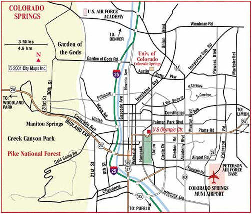
Figure 1-1 Regional Map of Colorado Springs
- Local media weather information on the internet - weather information is gathered from the internet either through searching the individual websites or the twitter releases immediately received by the operator on duty. Some of the twitter weather updates are posted on NewsFirstWeb, kktv11news, NEWSCHANNEL_13, NewsFirstToday and KXRM. These are severe weather information sources from local Colorado Springs meteorologists. The websites that are also normally searched include Weather Underground, weatherforyou.com and NOAA.
- Digital Weather/Hazard Alert Monitor - the system displays an audible alert and automatically broadcasts National Weather Service (NWS) alerts. This device is located next to the TMC operator console station.
- CDOT Weather Stations - CDOT operates two weather stations located along the I-25 corridor, one at MM 146 near Garden of the Gods Road and the other at MM 163 near Monument Hill. The weather station data include temperature, precipitation, dew point, humidity, wind (mph/dir), gust (mph/dir) and visibility (miles). This information is updated every 30 minutes and is available on the COTRIP.ORG website.
- The City of Colorado Springs Street Department utilizes 16 grids for snow removal. They determine road conditions from spotters as well as Road Weather Information Systems (RWIS) for those grids to determine the priority of snow removal for Colorado Springs.
Figure 1-2 Colorado Springs Street Division Grid Map

- RWIS on the Colorado Springs Scan Web System consists of seven remote weather stations that act as an early warning system during storm conditions. The stations are strategically located throughout the city. The system provides comprehensive information about air temperatures and wind speed, pavement temperatures, sub-pavement temperatures, chemical concentration and the freeze point of roadways, which effects not only icing potential but also the type of treatment the Street Division applies on hills and at intersections. The information refreshes every 15 minutes and is available to City employees on the web. The weather station locations are:
- 21st Street at Skyview
- Centennial Boulevard at Allegheny South
- Highway 24 at Marksheffel
- Jamboree at Chapel Hills
- Pikes Peak Avenue at Union Boulevard
- Star Ranch Road at Highway 115
- Platte Ave. at Powers Blvd
2.1.2 CDOT Signals
The CSTMC handles the signal timing and maintenance for the signals in the Colorado Springs area. This includes CDOT signals that are part of the on- and off-ramps from I-25. The CDOT signals were contracted over to the City of Colorado Springs for both maintenance and timing related issues.
2.1.3 Signal Systems and Control
The traffic signals in Colorado Springs are connected and controlled from within the CSTMC facility, providing the radio communication link is operational. This allows timing plans to be managed remotely from within the control center without a technician having to respond to the control cabinet at each intersection -. There are traffic cameras with video feeds back to the CSTMC and 120 signalized intersections that can be observed from the existing TMC cameras. However, the cameras have limited capabilities in adverse weather conditions due to limited visibility distances in fog and blowing snow and from the ice and moisture that adheres to the camera exterior protective globe.
2.1.4 Traffic Management Centers
The CSTMC is one of four centers in Colorado. There are three CDOT operated facilities which include the Colorado Traffic Management Center in Golden, Colorado, the I-70 Hanging Lake Tunnel Center and the I-70 Eisenhower Memorial Tunnel Center. All three facilities are 24-7 operations. Both the Hanging Lake and Eisenhower Tunnel centers serve as regional facilities for their particular area of responsibility in Colorado, mainly in and around the tunnels along Interstate 70. The CTMC located in Golden is a statewide center for collecting and distributing traffic information. The CTMC takes over VMS control after-hours but does not take over signal timing plans or maintenance issues after-hours.
The CSTMC maintains staffing after-hours under very limited circumstances. One possible situation involves a major incident on I-25 with either a total blockage in one or both directions or partial lane blockages estimated to last over 2 hours. The other situation would be following an activation of the Emergency Operation Center (EOC) by the Colorado Springs Office of Emergency Management for adverse weather conditions with a likelihood of highway closures in the region. Under these circumstances one operator may stay after-hours at the TMC. The operator activities could include activation of VMS, coordination with CDOT on State road closures, coordination with the EOC on other arterial street closures, and provision of updates to the media on highway closures or incidents.
The weather related VMS messages are designed to warn motorists of road and weather conditions downstream. The message content is usually intended to inform of closures or limited visibility or hazardous conditions that hopefully results in drivers reducing speeds for the conditions or totally changing travel plans to include staying off the highway. If adverse weather conditions occur after normal CSTMC hours, the CTMC in Golden will normally place up advisory messages on the VMS.
The CSTMC has a limited staff and no availability to call in additional staff without the consequence of an overtime commitment which is not feasible due to the budgetary restrictions. One traffic signal technician is on call and can respond on overtime for emergency situations when traffic signals are inoperative. Following a weather related incident the changing of VMS is either conducted by the CTMC or the CSTMC during normal operational hours. Non-emergent traffic signals issues are resolved when the traffic signal technicians return to work on their normal work schedule.
2.2 Concept of Operation
This section provides two scenarios to demonstrate how the CSTMC envisions weather information being integrated into transportation operations. Weather integration is most critical when a severe weather incident occurs which will likely have a major impact for the traveling public and the roadway system.
The following two events provide examples of the vision of our concept of operation after an analysis of the CSTMC is complete. The selected roadway segment focused upon during the winter storm event is representative of many other arterials in the Colorado Springs area.
2.2.1 Fog Event
On a Tuesday morning in early May a fog system moves down the front range of the Pikes Peak region. The visibility on Monument Hill is approximately 500 feet. The sight distance is estimated by a CSP trooper who works in the area. The traffic cameras can just barely see the highway. The intersections in the Colorado Springs area are clear with unlimited visibility.
The CSTMC operator receives the morning email from Skyview Weather indicating the northern portion of Colorado Springs and El Paso County can expect heavy fog rolling in after 8 am and clearing by later morning. Other weathers sources received as tweets at the CSTMC also confirm the high likelihood of foggy conditions.
Fog causes two major problems for travel in the region. One problem is with highway travel with motorists traveling at an unsafe speed that fails to allow for sufficient stopping time for an incident that may occur in front of a motorist. It is difficult for the CSTMC to properly identify and verify an incident under foggy conditions and post the information on the VMS due to the limited visibility from the cameras. Fog warnings on VMS need to be placed upstream of the fog to warn driver prior the condition. When there is an incident blocking a traffic lane in a foggy location any VMS close to the incident also in the foggy environment may not be readable with limited visibility from the fog. The other problem is traffic signal video detection under foggy conditions. This may result in some directions of travel not getting any or sufficient green time at an intersection.
The CSTMC operator monitors the highway traffic cameras and places a message on a VMS sign to warn motorists northbound on the Interstate to expect heavy fog and limited visibility ahead. As the fog moves to the south it is pretty obvious that it will approach the northern end of Colorado Springs around 8 a.m. The operator notifies the signal technician for the north end of the city of the approaching fog conditions. The signal technician goes into the system and places his intersections into recall for 3 hours. The recall setting allows all directions of traffic including turning movements to get a set amount of green time without utilization of detection equipment to determine if vehicles are in queue at an intersection. The detection mode for fog on the video detection system is less than adequate and the reason for the manual recall.
At approximately 8:30 am the CSTMC operator observes from the intersection cameras that the fog has lifted and notifies the signal technician. The signals are then placed back into their normal timing plan. The VMS message for the limited visibility is turned off.
A fog event is infrequent in the Colorado Springs area and normally is isolated to a particular section of Colorado Springs and not the entire City. It normally occurs in the morning hours during the morning commute and moves through a particular highway corridor and may last from 15 minutes up to two hours.
The anticipated impacts include:
- The intersection cameras are unable to determine the traffic volume and backups.
- The video detection cameras are unable to detect vehicles approaching the intersection and fail to provide a call for a particular direction of travel causing certain directions of travel to not receive green time, resulting in traffic backup and citizen complaints.
- Traffic is moving at slower speeds with increased following distance which would impact timing plans.
With short term duration of the fog conditions the necessary fix would be to get all the effected signalized intersections into recall to make sure all phases receive adequate green time to facilitate the movement of traffic at the intersections. When the conditions clear, the prior timing plans need to be reinstated.
The one unresolved dilemma revolves around a fog event that occurs after-hours. Without on-duty operators the visual inspection of conditions is not possible. While the CTMC in Golden does receive live video feeds of the CSTMC cameras they have limited staff after-hours and only play a reactive role for something like fog that occurs in the Pikes Peak region. They do not monitor cameras feeds for activity but do put up VMS if contacted by CSP or CDOT. While 90% or more of the fog conditions are on the Monument Hill area, only a small percentage of them move south and have an impact on the traffic signals in the Colorado Springs area. For that reason in would not be feasible for the CSTMC to contact the on-call signal technician based on the possibility of fog moving into the area. The overtime budget is already stretched and this additional expenditure could not be justified.
2.2.2 Winter Snow Storm Event
During the last week in October on a Monday, there is a weather forecast for a severe snowstorm to move into the region by 6 pm. All day long on Monday the CSTMC operator is receiving weather updates from all the available weather sources. The Colorado Springs Emergency Operation Center is activated based on the storm prediction of 12 inches of snow for the region.
At 4 pm the weather service predicts the snow to start falling by 5 pm during rush hour. The decision is made to place the signals in recall for the evening until the morning when the signal technicians return and can evaluate the conditions.
On Tuesday morning the weather service indicates the snow storm is moving out of the area after dropping 10-15 inches of snow in various locations in Colorado Springs. Temperatures are to remain below freezing for the week with limited sun to melt the snow. The CSTMC believes, based on the weather and road conditions, that the modified traffic signal plan should be activated for the week until the roadway is cleared and traffic flow returns to normal. While plowing did occur, the roadways are still icy packed and traffic continues to travel at speeds well below the posted speed limits. Motorist at intersections still cannot see and stop in the designated traffic lanes where video detection cameras can detect waiting traffic for through or turning movement, and therefore it is necessary to keep the signals in recall.
A winter snow storm event is unpredictable and could occur anytime between October and April in the Colorado Springs area. There is usually some advanced warning for a snow storm. The storm may impact the entire City for just an hour or two or a few days. A majority of storms that occur overnight or in the morning hours can expect to be mostly cleared out and with traffic returning back to normal by the noon hour.
The anticipated impacts include:
- The intersection cameras are unable to determine the traffic volume and backups.
- The video detection cameras are unable to detect vehicles approaching the intersection and fail to provide a call for a particular direction of travel causing certain directions of travel to not receive green time, resulting in traffic backup and citizen complaints.
- Traffic is moving at slower speeds, increased following distance, have increased stopping distance and slower acceleration at start up.
- With snow covered roadways drivers do not always have proper vehicle placement to reach the zone for the video detection cameras.
- The city has 15-20 intersections with grades or other characteristics that are impacted by slick roadways. It is necessary to place these signals in recall because motorist may not able to see the lane markers in order to place their vehicles at the intersections where video detection can properly work. Additionally the increased safe following distance on the grade would be significant enough that the detection would not recognize addition vehicles approaching and immediately revert to a red condition. Recall would provide the necessary green signal time to allow traffic to proceed through the intersection where the normal timing plan would likely not provide for the necessary movement of traffic.
The first priority for the CSTMC during the storm event is to get the signal time plans into recall to provide green time for all phases at the intersection. The next is to look at a modified signal timing plan to accommodate an extended period of time with adverse road conditions. Finally when the conditions clear, the timing plans need to be reversed and the prior timing plan reinstated.
The same unresolved dilemma as in the fog event revolves around an event like this that occurs after-hours or returns to normal conditions after-hours. The CSTMC needs to determine a best practice for these situations.
The CSTMC needs to collect certain weather and roadway data that will necessitate the modification of signal timing plans. With fog and blowing snow it will be the visibility distance that will start to impact the detection capabilities at the intersections. With falling snow it will be the accumulation level that will start to impact travel speeds.
2.3 Integration Needs
The Self-Evaluation Guide assisted the CSTMC in identifying their most important operational needs. The Traffic Control Operations received the highest rating based on the inputs. The Advisory Operations, Institutional Coordination and Weather Information Processing and Gathering received a medium priority (see Table 2-1).
2.3.1 Traffic Control Operations
The Traffic Control Operations includes the improvement of safety at intersections during weather events and the improvement of traffic signal timing during weather events to facilitate traffic movement. The winter weather in the Colorado Springs area can range from similar conditions throughout the city to delayed impact at various times throughout the city with some portions of the city having no adverse conditions at all. It is necessary to have weather and road conditions accurately updated throughout various parts of the city.
Winter driving is the most problematic, resulting in an increased crash rate at intersections. It is difficult to determine the actual percentage increase of the crash rate since the City of Colorado Springs frequently goes on Accident Alert status during the adverse winter driving conditions and the non-injury crashes do not get reported and counted. Under Accident Alert status a motorist does not get a police response to investigate the crash providing there are no injuries and no drugs or alcohol are involved. The motorists exchange information and complete their own traffic accident reports at a later date and time. This Accident Alert status is activated when there are more crashes occurring then can be investigated by law enforcement personnel. The increased crash rate has to do with many factors. One is the grades at intersections making it difficult to stop on icy roads when approaching the intersection or to start accelerating after stopping. Another is the normal stopping distance and ability to stop when the light cycles from green to amber to red.
The CSTMC management believes that traffic operations on arterial roadways can be improved in inclement conditions by utilizing weather-related signal timing plans that will accommodate changes in driver behavior and a disruption of video camera detection equipment. It should also help improve safety at intersections. The CSTMC needs to verify the standard practice of extended amber and red times during traffic signal timing modification in adverse road conditions.
Weather has an effect on traffic flow along signalized arterial roadways. This is primarily due to a reduction in visibility, a reduction in pavement friction and an impact on driving behavior and vehicle performance such as maneuverability and traction.
During inclement weather, primarily snow and ice, drivers increase following distance, reduce speed and utilize a slower acceleration rate. Weather can also increase both crash frequency and severity. Since timing plans are designed for normal driving conditions, the timing plans may not be as favorable when traveling on roadways in inclement weather and road conditions.
Inclement weather and pavement conditions generate reductions in traffic volumes and speeds, and increased delay and congestion. This weather-related delay can be alleviated by implementing modified signal timing plans that account for slower travel speeds and lower traffic flow rates or volumes.
Weather, primarily fog and snow, impact the video detection of vehicles at intersections. Vehicles cannot be properly detected due to the weather conditions and road conditions. Weather such as fog or blowing snow can obstruct the video detection. Snow or ice covered roadway markings can result in drivers stopping in locations at an intersection which are out of the video detection camera zone and therefore result in no detection of vehicles.
There are two approaches for the CSTMC to improve signal timing plans. One is to place signal plans into recall when the camera detection is obscured by weather conditions. This will guarantee every phase of the signal is operational for every direction of travel even when no vehicles are detected by the video detection system. The other is to modify signal timing to accommodate changes in driving behavior based on driving conditions.
This will require gathering statistical data during inclement weather and evaluating the impact to the roadway during the event. Currently it is fog, freezing rain, blowing snow and snow covered intersections that mostly impact traffic signal timing plans. Detection issues due to the weather and road conditions require manually placing the traffic signals into recall to provide assurance that all directions of travel at the signal get a green signal during the cycle. The CSTMC needs to establish the predefined threshold for conditions to activate a modified signal timing plan.
2.3.2 Advisory Operations
The advisory operations include providing better pre-trip weather conditions information to aid travelers in their decision-making and the improvement of message content on VMS, 511, web sites, etc.
The CTMC in Golden, Colorado handles the updates to the 511 Colorado highway advisory systems. The CSTMC can work on improving message content on VMS for the conditions downstream on the highway by either listing the conditions on the VMS or encouraging drivers to utilize the 511 system to check on conditions. Many of the VMS in the region are two-line signs which limits the message content that can be effectively displayed. The use of Twitter in the CSTMC started in the summer of 2009. The tweets generated on road and weather conditions, accident alert status, and crashes in the region are an excellent method of using new technology to provide motorists information that may aid in decision making before heading out on the roadway. Nearly all the local media in the region follows the CSTMC tweets on traffic crashes and road conditions. The CSTMC needs to work on marketing the information available to the public so more citizens are aware of the travel information available listed on the CSTMC twitter account or the City of Colorado Springs web site.
2.3.3 Institutional Coordination
The institutional coordination includes improved coordination with local public safety and emergency agencies and more coordinated responses and information with adjacent jurisdictions/regions.
The CSTMC primary coordination is with the Colorado Springs Police Department, the Colorado State Patrol, CDOT and the CTMC. The CSTMC shall continue to work on enhancing the coordination effort with these agencies.
2.3.4 Weather Information Process and Gathering
The weather information process and gathering includes assistance in interpreting weather information and how best to adjust operations in light of that information, better real-time information on road conditions during weather events and better prediction of impact of weather events including assessment of reduction in capacity.
The CSTMC personnel need to obtain training on interpreting and utilizing weather station information. Combining the weather station information with additional weather forecast information will allow the CSTMC to make proactive operational decisions in a timelier manner. This information can be distributed to the traffic signal technicians as well as the general public with the VMS and the CSTMC account.
2.4 Integration Solutions
The CSTMC analyzed each integration strategy based on the current integration level and the Guide recommended integration level. The CSTMC personnel then determined a chosen weather integration level based on what was thought to be most feasible for the CSTMC. The integration strategies are listed in Table 2-3 below. The levels of integration are described in Table 2-4.
The levels of integration are described in Table 2-4 below to provide an understanding of what the strategy is that the CSTMC has chosen.
The CSTMC determined the variety of impacts and requirements on various aspects of TMC operations, procedures, and capabilities in the five dimensions of integration along with the necessary steps in order to successfully achieve a specific level of integration that will meet the CSTMC needs. The five dimensions of integration described in the Guide are described in Table 2-5.
In this section each of the integration strategies is listed with a summary of the CSTMC action steps to achieve the level selected and the possible cost of implementation for the chosen level.
2.4.1 Use of Internal Weather Information Resources
This item pertains to the use of weather data and information resources that are available to the CSTMC and to the personnel assigned. The use of internal weather information resources for level 3 utilizes radar, satellite, ASOS and AWOS data, and general zone-type forecast information. This level of integration will provide the CSTMC with data on a local and regional scale. Radar and satellite will provide past and present data on possible precipitation over a designated region while ASOS and AWOS will provide observations of conditions at precise, pre-determined locations. General zone-type forecast information will give the TMC a broad picture of possible weather events that may affect the region. These types of forecasts will provide information on a regional scale, including expected maximum and minimum temperatures, average wind speed and direction, cloud cover, chance of precipitation within the region and range of timing associated with precipitation. The TMC must also incorporate data from RWIS Environmental Sensor Stations (ESS) and other weather networks that may be available for a given location. ESS will provide the TMC with weather directly adjacent to the road allowing for better understanding of weather conditions affecting the road surface and traffic flow. The ESS observations may include, but are typically limited to air temperature, relative humidity/dew point temperature, wind speed and direction, pavement surface temperature, pavement surface condition and chemical concentration or freeze point temperature and visibility.
Based on the steps listed in the five integration dimensions for levels 1-3, the CSTMC will need to identify the staff member(s) to be trained on RWIS data. The RWIS data are already available at the TMC. This will be one of the TMC operator positions. The actual processing of the RWIS information will need to be established and documented into a procedure. Most of the necessary equipment is in place to proceed so there are no initial projected costs to implement. Prior to the start of utilizing the Self-Evaluation and Planning Guide, the CSTMC would only check weather forecasts occasionally, primarily on the internet. In the past 6 months the CSTMC has greatly increase the amount and type of weather data that are received at the center. These additional steps to improve the data flow from the various sources have elevated the CSTMC to a level three. It would be possible to reach level four using data from Automatic Vehicle Location (AVL) and Mobile Data Computer (MDC) sources and internal radio communications. The CSTMC will revisit the needs following implementation of the plan to try to determine moving to level four if necessary for additional weather information resources.
2.4.2 Use of External Weather Information Resources
This item pertains to the use of weather information resources generated by weather service providers external to the CSTMC. The use of external weather information resources for level 3 requires road weather information to be reported to the TMC on scheduled intervals from field observations or instrumentations located within the right-of-way or roadway environment. The reports will provide weather information that covers all routes within the TMC jurisdiction to aid in decision making processes. These data will include road conditions, current weather conditions and past weather conditions.
Based on the steps listed in the five integration dimensions for levels 1-3, the CSTMC will, as in use of internal weather information, need to identify the staff member(s) to be trained on the RWIS data. A supervisor at the Street Department has offered his assistance to provide the training on RWIS data. With all the weather information available the CSTMC will need to identify which information will be utilized and how it will be processed. The thresholds also need to be established for when to start considering a signal timing modification, and a procedure will need to be established describing that threshold and the implementation. The signal timing modification to recall will be easy enough to determine based on failure of video camera detection. The challenge will be creating a modified signal timing plan based on adverse road conditions. A pilot test on modified signal timing during inclement weather can help determine if any addition equipment costs will be necessary or if the existing sources of information collection and sharing with the CSTMC are sufficient.
The CSTMC could expand to a level four with a contract to provide weather forecasts targeted specifically at the TMC operational needs. There are major budget cuts including personnel in both 2009 and 2010, and a fee based contract would be prohibitive with so many city employees being permanently eliminated. So unless a free service is provided or a grant is obtained to pay for such a contracted service, there is no possibility of paying for a contracted service with the existing CSTMC budget.
2.4.3 Availability of Weather Information
The weather data provided by surface transportation weather forecast vendors will allow the TMC to better manage traffic during adverse weather. The TMC will have data when needed to make informed decisions regarding weather conditions.
Based on the steps listed in the five integration dimensions for levels 1-4, the CSTMC will need to determine how to display the radar and/or satellite information in the TMC. There might not be any additional costs utilizing the existing computer monitors or video wall to display the weather data. One challenge in implementing this approach has to do with the how busy the TMC becomes with adverse weather conditions and the increase in traffic crashes. Depending on the number of operators working, it can sometimes become overwhelming to just keep up with the constant changes involving the traffic and crash situations. Having someone free to obtain and or display the weather data and make decisions could even be more challenging.
2.4.4 Frequency of Weather Forecasts
Weather forecasts can be provided at different frequencies during a given time period. The frequency with which a forecast is provided reflects the level of information detail that is required by the TMC for decision making, and higher frequencies involve a more sophisticated forecast generation and forecast utilization. This is usually a progression from a discrete level to a higher level and not necessarily an accumulation of all the individual components of the prior levels. Frequency of forecasts range from a per-request basis to hourly resolution weather forecasts.
The frequency of weather forecasts at the proposed Level 3 will extend the features of a general condition weather forecast by permitting a refinement of the forecasted weather conditions several times a day with new forecasts. The value of these forecasts still will be limited as the detail provided is limited in content. TMC operations would use the periodic forecasts to more frequently adjust traffic operations in response to variations in forecasted weather conditions.
Based on the steps listed in the five integration dimensions for levels 1-3, the CSTMC would need to establish a procedure for distribution of the weather forecast within the TMC. This procedure will also need to identify the person(s) responsible to collect the data and additionally deal with after-hours weather forecasts. The center will need to establish performance measures to assess the utilization of frequent forecast information. The CSTMC should not have any expenditure costs for this item.
2.4.5 Frequency of Road Weather Observations
This item pertains to the frequency of data acquisition and generally reflects the value and level of utilization within an operational environment. The frequency of road weather observations at the proposed Level 3 will combine the standard hourly flow of weather observations to include identification of critical operational situations when weather observations exceed thresholds predefined by TMC personnel. This will enable TMC staff to quickly identify locations and weather situations that are most critical to the TMC daily operations.
Based on the steps listed in the five integration dimensions for levels 1-3, the CSTMC will also need to determine the frequency for distribution of the road weather observations in addition to identifying the person(s) responsible to collect the data. Additionally, dealing with after-hours road weather observation is an issue. The center will also need to establish performance measures to assess the utilization of weather and road weather observations. The CSTMC should not have any expenditure costs for this item.
2.4.6 Weather Information Coordination
This item involves the exchange of information to support decision-making and operations within a TMC. The weather information coordination at level 2 will build an intra-TMC weather information coordination committee with a staff member assigned to coordinate weather information activities within the TMC, or assign a single staff member to explore the same issues as the intra-TMC committee with an additional responsibility to perform ongoing efforts to better identify and address weather needs.
Based on the steps listed in the five integration dimensions for levels 1-2, the CSTMC would need to establish training for the TMC staff on weather information in addition to establishing some coordination with the local metrological community. The CSTMC should not have any expenditure costs for this item.
2.4.7 Extent of Coverage
Extent of coverage for level 3 will require the CSTMC to expand the coverage of weather information devices to provide information about weather conditions from multiple locations in a specific corridor. The information will be obtained from specific locations in the corridor known to experience traffic problems caused by weather conditions. Examples of strategies that could be implemented with this level of deployment include coordinated signal timing plans to promote traffic movement on an emergency or evacuation route and deploying diversion routing around a flooded section of roadway. Weather information will need to be tightly coupled with traffic information from the corridor. This level of integration will be needed to support automated traffic management responses.
Based on the steps listed in the five integration dimensions for levels 1-3, the CSTMC would need to expand the extent of coverage. An additional 80 cameras are in the process of being installed over the next few years which will help in the citywide coverage by use of cameras. There are projected expenditures for the camera purchase and installation which are already part of a grant. There are no plans for street sensors which would be the responsibility of the Street Department which like all general Colorado budgets have been drastically reduced for 2010.
2.4.8 Interaction with Meteorologist
This item pertains to interaction with meteorologists by TMC personnel and provides opportunities to learn more about how to incorporate weather information in TMC operations.
Interaction with Meteorologist at level 2 will require the development of a check list of routine weather awareness activities. In this strategy the focus group or informal gatherings of local professionals in the transportation management and weather communities will pursue activities to heighten the awareness of mutual interests, needs, and challenges in surface transportation weather. These activities will result in the development of a structured check list of routine weather awareness efforts that will be addressed as a shared activity.
Based on the steps listed in the five integration dimensions for levels 1-2, the CSTMC will need to establish the necessary guidelines for communication between the TMC staff and the weather community. There should not be any costs associated with this item.
2.4.9 Alert Notification
This item pertains to providing an information exchange process to heighten awareness of weather-related operational issues. The alert notification for level 3 will replace the telephone call system with a manual email or paging system. Operators in the TMC will send email alerts of developing or impending weather events to key responders. The advantage of this type of system over a telephone call list is that multiple individuals can be notified simultaneously thereby decreasing the time it takes to notify key individuals. Individuals needing more information can then contact the TMC to obtain more detailed information about the impacts and threats caused by the weather event. The CSTMC will determine the type and extent of alert notifications that are possible from the traffic control cabinet lid and the different failures from which notifications are possible for weather related events.
Level 4 would include automated road weather system-generated notifications. This would be a costly upgrade to any existing systems in place and would be cost prohibitive, and for that reason level 4 was not considered.
Based on the steps listed in the five integration dimensions for levels 1-3, the CSTMC would need to establish which weather events would trigger TMC action on signal timing modifications and how those notifications are made. The creation of a procedure is necessary to identify the steps for the notification process. The costs should be minimal to implement the alert notification.
2.4.10 Decision Support
This item pertains to the use of weather information to make effective transportation management/operations decisions. The decision support for level 2 will require TMC response personnel to meet with other stakeholders and responders and develop a series of pre-defined advisory, control, and treatment responses to be performed during specific weather events. These predefined responses will be incorporated into the standard operating procedures of the TMC, and operators will have ready access to these responses, either through the use of flip cards or other documentation. Weather event thresholds will be defined that trigger specific types of responses by the TMC operators.
Based on the steps listed in the five integration dimensions for levels 1-2, the CSTMC would need to establish once again the weather events that would trigger TMC action on signal timing modifications and determine how those notifications are made. The criteria to identify the change in street conditions that will allow the TMC to revert back to the normal signal timing plan must also be established. This will require the establishment of a protocol on when these decisions are made and who will make the decisions. The timing technicians will need to determine the appropriate time plan(s) for the adverse weather conditions. The expense will mostly be in man-hours to establish the appropriate timing plans to implement during the adverse weather conditions.
2.4.11 Weather/Road Weather Data Acquisition
This item pertains to the level of technological sophistication used to process and manage weather data. The weather/road weather data acquisition will have TMC operators access weather information not only from external sources but also from agency owned and operated weather monitoring stations to acquire road weather information. Weather monitoring devices will be installed at strategic locations and will allow the operator to access detailed weather information from specific locations. Depending upon the extent of coverage, information could be from scattered locations or an entire region or area. This level will require a more extensive communications network to bring back the weather information from the remote sensors to the TMC.
Based on the steps listed in the five integration dimensions for levels 1-3, the CSTMC would need to develop algorithms that monitor City owned and operated weather information sources on a periodic basis. Procedures need to be established on the use of the information.
3 IMPLEMENTATION OF INTEGRATION PLAN
The plan for the CSTMC is the creation of operator initiated signal timing plans based on weather observations and predictions. The process involves utilizing the City of Colorado Springs Street Department grid map shown in Figure 1-2 and performing signal timing modification in each of the 16 grids. It is also a future goal to develop an automated modified signal timing plan in any or all of the 16 grids for weather related incidents. The automation can help reduce the need for after- hour staffing to manage the system.
The CSTMC has elected to conduct a pilot program and the timeline is outlined in Section 3.1 below. The pilot project implementation will officially start in January, 2010. The plan is to utilize just a single grid from the 16 grids available. The project will include fine tuning and evaluating the signal timing plan in the grid selected. At the completion of the pilot project the signal timing plans can be implemented in all 16 grids.
3.1. Implementation Schedule (Phasing and Sequencing)
The tasks are split into two categories. One is the weather integration related tasks and the other is traffic signal timing pilot project tasks. Each task and the time frame for both start and completion are listed below in table 3-1.
3.2 Cost Estimates
Nearly all expenditures will be in personnel. The increased workload for the CSTMC personnel will be absorbed into the normal work schedule. Since the number of staff hours necessary for implementation will not be done on overtime, there will be no hard cost expenditures.
3.3 Operations and Maintenance Requirements
The operations and maintenance requirements for implementation should be feasible with the CSTMC personnel.
3.3.1 Staffing
It is anticipated that the existing staff at the CSTMC should be sufficient to handle the increased work load for both the implementation and maintenance of signal timing plans for adverse weather condition.
3.3.2 Training
There will be two components of training during implementation. One session of training involves operational training for a TMC operator in the area of gathering and evaluating the weather information. The other involves developing and providing training for the traffic signal technicians on the development of traffic signal timing plans based on adverse weather conditions.
3.4 Anticipated Challenges and Constraints of Integration
There will be some challenges facing the CSTMC for implementation. Recent budget cuts for Colorado Springs have reduced the number of traffic signal technicians assigned. This staffing reduction has already increased the individual workload for each of the remaining assigned traffic signal technicians. Another challenge will be weather-related and having a sufficient number of adverse weather days to implement and test the modified signal timing plans after they are created. An additional challenge and constraint has to do with budget reduction in 2010 and 2011, and any unexpected expenditure during implementation could hamper the implementation timeline.
3.5 Possible Future Activities
The CSTMC identified some desirable activities for the future should funding become available. The activities include contracting with an outside source for tailored road weather forecasts, obtaining streaming information from maintenance vehicles into the TMC, adding additional RWIS in key locations, extending TMC hours and the necessary staffing, and expanding out to include other weather events such as fog to include in the signal timing plan modification. The CSTMC will also revisit the Guide in approximately a year or two to see if other possible weather integration strategies and or levels should be pursued.