
3. Existing Corridor Scope and Operational Characteristics
| Overview — This chapter provides a general description of the subject corridor including corridor boundaries and the networks within the corridor, identification of corridor stakeholders, current conditions experienced by each corridor network, existing and planned corridor assets (including a review of the regional ITS architecture), the institutional framework, identification of individual network and corridor operational characteristics and deficiencies, an assessment of the potential for ICM, and a vision statement indicating how the corridor will operate in the future. The information in this chapter sets the stage for the Operational Concepts described in the subsequent chapters. |
3.1 Corridor Boundaries and Networks
| Guidance — The Concept Exploration and the System Conception activities (within the systems engineering process) include two levels of corridor boundaries delineation analyses. The initial corridor identification and boundary delineation identified during concept exploration is primarily conceptual and qualitative in nature, relying on local knowledge (and possibly a high-level review of any available data on travel patterns and markets), combined with engineering judgment, to ferret out the rough impact area of the corridor. This is followed by a more quantitative analysis conducted during system conception that takes into account current and forecasted travel patterns, the travel market or markets that are served by the proposed corridor (and their respective needs and issues), operational characteristics and typical scenarios / events within the corridor, availability of cross-network connections and spare capacity, other conditions and deficiencies, etc. The results of the system conception level corridor boundaries analysis is documented in the Concept of Operations. |
The Generic Corridor is a largely linear band, approximately 15 miles in length, consisting of a freeway, adjacent arterials, and a parallel rail system as shown in Figure 3-1. The generic corridor is primarily a commuter corridor utilized for travel between the central business district of employment (in Metropolis) and commercial areas and suburban residential areas. At one end of the corridor is the Black Water River, which is the jurisdictional boundary for Metropolis. On the other side of the river, the Generic Corridor is divided between two cities: the City of Neptune is to the north of the rail line, and the City of Atlantis is to the south of the rail line. The Black Water River is crossed by four bridges: one for the freeway, one each for the freeway spur and the Broadway arterial (both of which empty into the central business district), and a railway bridge for the regional rail service.
The corridor is part of the Black Water River Metropolitan Planning Organization (BWRMPO) region and also part of an inter-regional multi-state corridor that is designated as an evacuation route. The networks comprising the generic corridor and their respective characteristics are summarized in Table 3-1.
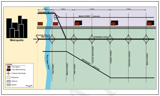
Figure 3-1. Map of the Generic Corridor
| Corridor Element | Characteristics |
|---|---|
| Freeway Network |
|
| Arterial Network |
|
| Regional Rail Network |
|
| Bus Transit Network |
|
| Black Water River Bridges |
|
3.2 Corridor Stakeholders
| Guidance — A "stakeholder" is any person or group with a direct interest (a "stake," as it were) in the integrated operation of the corridor and the associated networks and cross- network linkages. The number and types of corridor stakeholders will be dependant on the transportation networks included in the corridor and the proposed ICM concepts. All appropriate stakeholders need to be brought into the picture early on to make sure their needs are considered, and to determine how they will be involved in the process to plan and develop an ICMS. The list of stakeholders needs to be reviewed at key points throughout the ICMS development process to determine if any needed stakeholders are missing. In completing this section of the Con Ops, all potential stakeholders, even ones not involved in the development of the document, should be identified. If there are stakeholders identified that are not part of the concept development, plans should be made to contact those stakeholders to enlist their review of the document and participation in subsequent activities. |
The ICM stakeholders for the generic corridor are listed in Table 3-2, all of which were involved to some extent in the development of this Concept of Operations. Those with operational and management responsibilities for the individual networks are shown graphically in Figure 3-2.
|
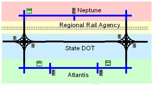
Figure 3-2. Operational Responsibility for Corridor Networks
Other agencies with operational responsibilities (not shown in Figure 3-2) include the following:
- Generic Bus Authority – operating on all arterials and freeways, servicing the Rail park and ride facilities.
- State Police – Enforcement, security, and accident investigation on the freeway.
- Neptune Police – Enforcement, security, and accident investigation on the Neptune arterials (including Main Street) and other local streets (e.g., cross-connections).
- Atlantis Police – Enforcement, security, and accident investigation on the on the Atlantis arterials (including Broadway) and other local streets (e.g., cross-connections).
- Rail Agency Police – Enforcement, security, and accident investigation on the regional rail network and stations.
- Fire Departments – ambulance services and HAZMAT for all networks.
3.3 Operational Conditions of the Generic Corridor and Included Networks
| Background — This section focuses on the operational characteristics of the corridor and the associated networks. Corridor attributes to be addressed in this section include the major traffic generators, primary travel markets served by the corridor, corridor demand and usage, and the types and frequency of events that impact network and corridor operations. |
The Generic Corridor provides transportation for the movement of commuters, freight, recreational, and other traffic, as summarized in Table 3-3:
| Period | Commuter | Commercial | Recreation | Other |
|---|---|---|---|---|
| Peak | 70 | 15 | 5 | 10 |
| Off-Peak | 30 | 30 | 15 | 25 |
The significant level of commuter traffic results in significant peaking characteristics within the corridor for both roadways and transit as shown in Figures 3-3 and 3-4.
The travel market within the Generic Corridor consists of the following trip types:
- Users with trips originating either in the corridor with a destination outside the corridor or outside the corridor with destinations within the corridor.
- Commuters traveling to / from the Metropolis central business district. The modal split between roadway and transit in this regard is approximately 70/30 during the peak periods and 80/20 in the off-peak periods.
- Commercial vehicles to and from the central business district.
- Users traveling within the corridor on local trips (i.e. both origin and destination within the corridor).
- Trips to markets, schools, places of worship, etc. Approximately 85 percent of these trips are on the roadway networks, with 15 percent on the transit networks.
- Courier / deliveries. Nearly all of these occur on the roadways.
- Traffic passing through the corridor (i.e. with neither origin or destination in the corridor) to access or pass through the central business district.
- Long haul travelers.
- Freight traffic and other commercial vehicles.
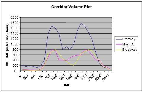
Figure 3-3. Roadway Use during Typical Work Day
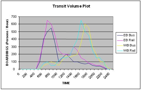
Figure 3-4. Transit Use during Typical Work Day
| Period | Local | Origin or Destination | Through |
|---|---|---|---|
| Peak | 60 | 30 | 10 |
| Off-Peak | 40 | 40 | 20 |
Traffic congestion along the roadway-based networks is a growing problem in the Generic Corridor, particularly during the peak periods. The congestion problems have resulted in a number of serious issues, such as loss of personal and professional time, increased fuel consumption, increased accident rates, environmental degradation, and traveler frustration. As congestion and delays have increased, actual throughput corridor-wide has actually declined.
On average, the regular freeway lanes experience Level-Of-Service (LOS) D during the peak periods, with an average peak period speed of approximately 35 mph. The freeway HOV lanes operate at a LOS of C with an average peak period speed of 55 mph. The two arterial facilities, Main Street and Broadway, both operate at a LOS of D with an average peak period speed of 25 mph.
Recent studies of the freeway operations indicate that congested conditions (i.e., average speeds of less than 40 miles per hour) typically exist during four hours of every workday: two during the AM peak, and two during the PM peak. The cause of this freeway congestion can be attributed to the following factors:
- Bottlenecks/Demand (Recurring) – 35 percent
- Incidents – 35 percent
- Weather – 20 percent
- Special Events – 10 percent
Arterials studies indicate that during the peak periods, approximately half of the drivers experience a "loaded cycle (i.e., having to wait at the signal for more than one green phase on the major approach) at 25 percent of the signalized intersections.
With respect to transit operations within the corridor, the roadway congestion problems noted above have also degraded the operation of the buses, particularly on the arterials and surface streets, making it increasingly more difficult for buses to maintain their published schedule. Specifically, 30 percent of the buses operating along the two arterials run behind schedule during the peak period (with 15 percent running behind schedule during the off peak periods). The express buses, which operate primarily within the HOV lanes of the freeway, also experience delays when moving out of the HOV lanes to exit the freeway and traveling along the arterials to service the rail stations. The peak period express bus service runs behind schedule 15 percent of the time.
The regional rail service has an excellent on-time performance record (better than 95 percent). The increasing roadway congestion has increased rail ridership to some extent; but it is still under-utilized in terms of its available passenger-carrying capacity, even during the peak travel periods. This is due, in part, to a relatively limited number of parking spaces at some of the rail stations, where the lots can fill up quickly during the AM Peak, and remain full until the PM Peak.
The average peak period travel times for the various networks for trips traveling the length of the corridor are provided in Table 3-5.
| Corridor Networks | Average Peak Period Travel Time per Person (minutes) |
|---|---|
| Freeway – Regular lanes | 26 |
| Freeway – HOV | 16 |
| Main Street | 36 |
| Broadway | 36 |
| Bus (Local) | 40 |
| Bus (Express) | 24 |
| Rail | 20 |
Due to the high percentage of freeway incidents, freeway and subsequently arterial reliability are low. The average freeway travel time of 26 minutes can fluctuate by more than 100 percent depending on the location and severity of the incident. Moreover, freeway incidents often result in a shift of trips from the freeway to the arterials, resulting in a 50 percent increase in arterial travel time, with a concomitant impact on the reliability of bus operations along the arterials.
The operation of regional rail network is very reliable (with, as noted above, an on-time performance record of better than 95 percent). The primary operational concern in this regard is occasional flooding of a section of track - particularly after heavy rains - which necessitates the deployment of a "bus bridge" around the service outage.
Based on historical data, the corridor has been experiencing on average an annual growth in demand of 2 percent spread over the corridor networks. Due to recent economic factors, such as the rise in gasoline prices, the spread has been shifting a little to rail. However it is expected that overtime if gasoline prices lower, some of the shift to rail will return to the freeway and arterials.
3.4 Existing Network-based Transportation Management / ITS Assets
| Guidance — This section essentially inventories the existing network-specific transportation management and ITS-based assets. The section should identify each asset and provide a brief description that explains the attributes of each asset. |
The various transportation agencies that operate networks within the Generic Corridor have implemented a variety of policies, strategies, and technologies to improve performance of their respective networks. The assets that support each network's operations and their attributes are summarized in Table 3-6, and illustrated in Figure 3-5.
| Network | Assets |
|---|---|
| Freeway Traffic Management System |
|
| Arterial Traffic Management Systems |
|
| Bus Transit Management System |
|
| Rail Transit Management System |
|
| Police and Fire Departments |
|
|
1 NTCIP = National Transportation Communications for ITS Protocols 2 TOD/DOW = time of day/ day of week 3 TRSP = Traffic responsive |
|
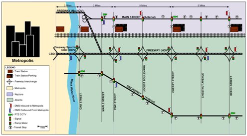
Figure 3-5. Existing Network-Based ITS Assets
3.5 Proposed Near-Term Network Improvements
| Guidance — This section captures any transportation management and ITS improvements that are likely to be implemented on networks within the corridor in the next few years. These improvements may factor into the development of an ICMS. Each improvement should be identified including any significant assets that are elements of the improvement. |
The current Transportation Improvement Plan (TIP) identifies an array of improvements for the region. Those improvements located within the corridor are listed below, and need to be accounted for in any subsequent requirements analysis and ICMS design. The improvements are categorized by network and responsible agency.
- Freeway - State DOT
- Upgrades to the freeway management system surveillance capabilities that include more detectors and full - coverage CCTV.
- Revised and upgraded incident management procedures for automated detection and response (including expanded freeway service patrols).
- Dynamic Message Signs (DMS) at additional locations along the freeway.
- Ramp metering enhancements to include HOV by-pass at selected locations.
- Road - Weather Information System (RWIS) along the freeway.
- Arterials - Neptune DOT and Atlantis DPW
- Retro-fit of the communications network (twisted - pair to fiber optics) for the traffic signal control systems.
- Upgrades to central software and controllers incorporating NTCIP. (Note: Retro-fit of communications and software upgrades are referred to as arterial system or arterial signal system upgrades in subsequent sections of the Con Ops).
- Rail - Regional Rail Agency
- In-terminal / wayside DMS (e.g. next train arrival) at all stations and platforms.
- Improved PA systems for in-vehicle annunciation and in-terminal announcements.
- Smart card system on the buses and at the train stations for transit fares. (Joint bus/rail transit improvement that will eventually cover region).
- Bus - Generic Bus Authority
- In-terminal / wayside DMS (e.g. next bus arrival / Route #) at each bus stop.
- Improved PA systems for in-vehicle annunciation and in-terminal announcements.
- Smart card system on the buses and at the train stations for transit fares. (Joint bus/rail transit improvement that will eventually cover region).
3.6 Current Network-Based Institutional Characteristics
| Guidance — This section describes the current institutional environment of the corridor, taking into account each network, the region, and any other institutions that will affect the integration of the corridor. Any mechanisms that have been established to enhance coordination (e.g., inter-agency relationships and agreements, information sharing, joint operational procedurals), be they at the regional or corridor levels, should be addressed. The section should also identify any institutional constraints that would affect integrated corridor management. |
This institutional fabric within the Generic Corridor is multi-agency, multi-functional, and multi-modal. Moreover, the authority for transportation-related decision-making is dispersed among several different agencies, including the State DOT, Neptune, Atlantis, the Regional Rail Agency, the Generic Bus Authority, Metropolis, as well as the various enforcement agencies and fire departments. Additionally, agencies of the US Government (e.g., FHWA, FTA, DHS) and their rules and regulation also impact the operation of the corridor. The management and operations of the various networks in the Generic Corridor (and the supporting ITS-based systems) have tended to be "stovepiped", with minimal communications between the transportation networks and their operators except for major events and incidents. As such, on a day-to-day operating basis, the corridor consists of independent networks and systems.
From a regional perspective, the Black Water River Metropolitan Planning Organization (BWRMPO) manages the development of the Transportation Long-Range Plan and the Transportation Improvement Plan (TIP). At a regional level, all the stakeholders that have been identified as Generic Corridor stakeholders take part in the identification and selection of metropolitan transportation planning region improvement projects. The BWRMPO structure includes a Board of Directors and the following two main committees:
- Elected Officials Committee: includes elected officials from all the jurisdictions in the region.
- Technical Officials Committee: includes technical officials from the various organizations that are part of the transportation planning process and have a stake in the selection of regional projects.
An executive director manages the BWRMPO. The executive director reports to and is appointed by the Board of Directors. The executive director manages a staff of 60.
The BWRMPO took the lead in establishing the Regional ITS Architecture (discussed in a subsequent section herein). As part of this process, the BWRMPO established a "Regional ITS Architecture Committee." This Committee, which reports to the two main committees, was given the authority to establish sub-committees and manage the procurement of technical support. The Regional ITS Architecture Committee maintains the architecture and technically supports the coordination of ITS projects. The Regional ITS Architecture promotes system integration, but has had limited effect on coordinating regional transportation management and operational activities. The Regional Architecture Committee is comprised of Transportation Management/ITS representatives from each of the regional networks and chaired by the BWRMPO Operations / ITS Director.
To facilitate the pending implementation of a Smart Card transit fare system, the Regional Rail Agency and the Generic Bus Authority have entered into an interagency agreement that creates a new unit in the Rail Agency to development, implement, and operate the Smart Card system. The unit will report to a three-person committee composed of a rail agency representative, a bus authority representative, and the BWRMPO Transit Initiatives Director. The three-person committee will primarily make design and operations decisions. Decisions that cannot be reached by the three-person committee are to be presented to the BWRMPO Board of Directors for action. The Smart Card System will be jointly funded based on a proportion of each entities smart card revenue generation. The Smart Card unit, on behalf of both agencies, will pursue any federal funds that are available for design and implementation of the system.
The State DOT is taking the lead in addressing regional incident management procedures for major incidents and related emergencies. A major part of this project is to coordinate incident and emergency management procedures with the adjacent jurisdictions transportation, public safety entities, and the Department of Homeland Security as required. To date no coordinating body has been established.
There have been a number of special major events in Metropolis over the past few years, each requiring special transportation management measures at both the regional and corridor level. For each of these events, the Mayor of Metropolis has requested from the other jurisdictions the formation of a special event task force to address the impact of these events. The task force looks at all aspects of venue management including transportation. Through the task force, a central command for transportation is established in advance that coordinates the planning, preparations, and event-day operations command. The task force identifies and implements special transportation operational strategies for the event to facilitate the access and egress of attendees and maintenance of existing travel. After each event, however, the task force, including the central command, is disbanded and all central command protocols are relinquished.
To facilitate the initial exploration and subsequent development of an ICM concept to the Generic Corridor, the State DOT, in coordination with the BWRMPO, established a Generic Corridor ICM Study Task Force. The ICM Task Force is responsible for determining the feasibility of developing and deploying such an ICM system, including identifying the associated operational, technical, and institutional issues. The development of this Concept of Operations and subsequent ICM system requirement is part of this responsibility. All the stakeholders identified in previous Table 3-2 are participating in the study in some capacity.
The current institutional environment seems to offer more opportunities than constraints in support of ICM. The coordination facilitated by the Regional ITS Architecture Committee and the special event centralized command model indicates that an institutional structure to support ICM could be established. Some specific issues that will have to be addressed in establishing an ICM institutional structure is the participation of the public safety entities in the corridor, the evolution of the Generic Corridor ICM Study Task Force, and the decision-making structure that includes how the Generic Corridor with ICM will be collectively managed and funded, and what will be the ultimate corridor decision-making body.
3.7 Regional ITS Architecture Review
| Guidance — Integrated corridor management builds upon regional management. An ICMS may be considered a "sub-regional architecture" in this regard. The development of an Integrated Corridor Management System (and the ICMS architecture) should therefore be compatible and consistent with the regional ITS architecture; and this requires an understanding of the various attributes that comprise the regional architecture and the associated management functions. This section presents a review of the regional architecture in which the Integrated Corridor Management System will function, including the current state of the architecture and how changes to the Architecture are currently handled. |
The generic corridor is part of a broader regional ITS architecture (refer to Figure 3-6), in which all the generic corridor stakeholders participated. The proposed functionality of the regional architecture includes the following:
- Real-time information sharing (data, video) between all agencies within the region. It is noted that the Regional ITS Architecture recommends the use of "ITS Standards as adopted by US DOT" for this purpose; but no additional details are provided.
- Clearinghouse of real-time information covering all critical routes and modes. This regional ATIS database integrates available information from agency-specific systems and TMCs / TCCs to provide a composite picture of the real-time status of the surface transportation network. The information is made available to all the region's agencies/TMCs/TCCs, other operating entities, and private traffic reporting entities.
- Regional coordination support between TMCs / TCCs, transportation agencies, and public safety agencies during "major" incidents, construction activities and special events (i.e., those for which the impacts cross most of the agency boundaries).
- A regional payment/financial clearinghouse, by which the same ETC tag/smart card can be used to pay transit fares, tolls and parking in the region.
The Regional ITS Architecture does not include inter-agency operations nor control of system components.
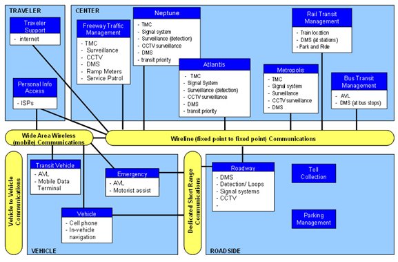
Figure 3-6. Regional ITS Architecture
Most of the proposed functionality has not yet been implemented. The aforementioned Regional Rail Authority / Generic Bus Authority Smart Card initiative will use the architecture in development of the smart cart system design so the system can be integrated with any expansion of the system to ETC tags for future tolls and parking payments.
The Metropolitan Planning Organization's Region ITS Architecture Committee maintains the Regional ITS architecture and provides technical support and review of ITS projects for their conformance to the regional architecture. For example:
- With Neptune and Atlantis both planning to upgrade their respective arterial signal systems, the Regional ITS Architecture Committee is taking an active role to make sure each system conforms to the Regional ITS Architecture and supports cross system communications and data/information transfers utilizing ITS Standards.
- The Regional ITS Architecture Committee has reviewed the State DOT's plans for the upgrade to the freeway management system that includes the expanded CCTV coverage, additional DMS signs, and ramp meeting and has concluded the systems' designs conform to the ITS architecture.
The Regional ITS Architecture Committee has not yet dealt with the modification or expansion of the ITS architecture. The Committee charter states that changes or additions to the Regional ITS Architecture, as might be necessitated by the development of an ICMS within the Generic Corridor, must be presented to the Committee in writing. The Committee will consider the merits of the changes and conduct a feasibility analysis. If the changes are feasible, and the Committee agrees that the changes are necessary for interchangeability and interoperability between agencies and their systems, the Committee must present the recommended changes and their finding to the BWRMPO Technical and Elected Official Committees for approval.
3.8 Individual Network and Corridor Problems, Issues and Needs
| Guidance — This section summarizes the problems, issues and needs of the individual networks and the corridor as a whole. Using the inventory information and other gathered data, coupled with stakeholder discussions, this section should address operational, technical, and, institutional deficiencies and constraints, thereby providing insight as to the types of problems being faced in the corridor. |
Many of the operational deficiencies within the Generic Corridor have already been discussed in Section 3.3. Congestion - particularly during the peak periods - represents a major problem along most of the networks within the Generic Corridor. Specific examples include the following:
- Each roadway network within the corridor is running below an ideal LOS except for the freeway HOV lanes. On average, corridor-length trips along the freeway under free flow conditions take 16 minutes versus 26 minutes under congested conditions.
- Congestion caused by incidents and other unplanned events has lowered the reliability of corridor travel to unacceptable levels, with average freeway corridor travel times fluctuating as much as100 percent on a day-to-day basis. The State DOT has implemented an incident management program; but it is focused on the freeway, with minimal coordination with adjacent and intersecting arterials.
- Of the 5 independent networks within the Generic Corridor, 4 have expressed their frustration with the impact of incidents, especially major freeway incidents. The lack of coordination between the networks in the corridor contributes to each network's inability to mitigate the impact of incidents and maintain some respectable level of service.
- Arterial travel is compromised by the inability to actively change and coordinate signal timing plans in response to current and changing demand patterns or reductions in arterial capacity due to arterial incidents. Any response to events that increase arterial demand / reduce arterial capacity requires manual interaction. Incidents on the freeway can further exacerbate these problems when freeway travelers shift to the arterials and temporarily increase demand. As a result, approximately 50 percent of arterial travelers sit through a loaded cycle at a quarter of the signalized intersections. The proposed arterial system upgrades to each of the major arterials will improve the operations of each individual arterial, but it will not provide for any traffic - responsive or adaptive management of the system, nor will it integrate operations with each other or other networks.
- The poor arterial performance also affects bus operations, making it increasingly more difficult for buses to maintain their published schedules and headways (e.g., 30 percent of the buses operating along the two arterials run behind schedule during the peak period). Improved operations along the arterials will assist in increasing the schedule adherence of the buses. However, the lack of any real-time information on arterial conditions is a concern for the operation of the future bus stop DMS network in that these signs may require significant manual intervention to keep riders properly informed about schedule delays.
- The express bus service is popular. However, due to the need to traverse the regular (and congested) freeway travel lanes to access the HOV lanes and the exits, and then travel along congested arterials to access rail stations, its operations do not meet traveler expectations.
The regional rail line is the most reliable of all the network alternatives and, on average, offers a shorter travel time (relative to the regular freeway lanes) to traverse the corridor. The rail is currently under utilized resulting in spare corridor operating capacity. The cause of this under utilization is mostly attributed to the lack of parking at or near stations; however, the lack of coordination between rail and bus schedules and their respective operations (e.g., "just-missed" bus-rail connections that increase a rider's wait time and level of frustration) is probably another factor. Even though the Bus Authority and Rail Agency have entered into an inter-agency agreement for the development of the smart card payment system, the coordination of overall schedules and service has been a subject of contention since the express bus and regional rail have always been viewed as competitors for the same riders.
Travel on each of the corridor networks - except for the Freeway HOV and rail line - is expected to further degrade as demand increase over the next few years, resulting in even more congestion. Each network has identified improvements to address their respective individual conditions, determining what will be necessary to address the predicted future level of demand. All the improvements focus on monitoring and managing/operating each network more efficiently. However, due to limited space, air quality conformity issues, community issues, and funding, large-scale physical capacity improvements are not feasible. Each of the networks that are experiencing congested conditions during the peak periods have indicate that eventually they will not be able to tweak out any additional performance on a network level.
Traveler information is another issue. Currently, the State DOT, the Regional Rail Agency, and the Generic Bus Authority manage websites for disseminating traveler information (including CCTV video images in the case of the State DOT site). However, this information is limited to these agencies' respective networks (i.e., freeway conditions, rail operations, bus operations).
Several corridor stakeholder workshops and interviews were conducted as part of the ICM Concept activity. Several additional corridor issues and needs were identified as summarized in Table 3-7.
|
3.9 Potential for ICM in the Generic Corridor
| Guidance — This section discusses how the corridor deficiencies and needs can be addressed from a corridor perspective by applying corridor management and cross-network operational strategies. The result of this section should be an assessment of whether or not ICM strategies can address the operational deficiencies that are limiting corridor performance. |
The Generic Corridor consists of 5 independent networks:
- Freeway (regular and HOV)
- Arterial – Main Street
- Arterial – Broadway
- Bus (local and express)
- Rail
Each of the corridor networks, except for the rail and HOV, are experiencing congested conditions and travelers are incurring increasing trip delays. This has a negative impact on overall corridor mobility, safety, and the region's economic competitiveness. In addition, unplanned events such as incidents on the freeway are eroding the reliability of the system such that travelers just expect being late to their destinations.
As defined,3 "Integrated Corridor Management" focuses on the operational, institutional, and technical coordination of multiple transportation networks and cross-network connections comprising a corridor. Moreover, ICM can encompass several activities which address the problems and needs identified in the previous section (e.g., integrated policy among stakeholders, communications among network operators and stakeholders, improving the efficiency of cross-network junctions and interfaces, real-time traffic and transit monitoring, real-time information distribution, congestion management, incident management, public awareness programs, and transportation pricing and payment).
One of the deficiencies that needs to be addressed — and a specific attribute of the Regional ITS Architecture — involves the exchange and sharing of real-time data. With real-time data and video among the networks, each network could monitor the conditions of adjacent networks to anticipate when travelers may shift to their network and take appropriate actions. Moreover, real-time condition information would provide the foundation for corridor-wide traveler information.
Combining surveillance among networks, especially the full coverage CCTV being implemented on the freeway, could be used to obtain information on network junctions. The information from the CCTV can also be used to verify conditions and provide information to incident first responders so an appropriate response can be dispatched, as well as the selection and execution of appropriate corridor incident mitigation strategies.
Since both Neptune and Atlantis are enhancing their respective arterial signal systems in the corridor, a few corridor strategies could be readily introduced in conjunction with these upgrade projects. To address freeway/arterial congestion at the ramps and adjacent intersections, integrated operations of adjacent ramp meters and signalized intersections could be implemented. There is also potential to provide signal priority to arterial buses and express buses that are delayed by ramp and arterial congestion. Signal priority on the arterials would also increase the schedule adherence of buses and may be an alternative to parking at stations for those that would like to use the rail system. Adding arterial surveillance as part of these system enhancements is also a possibility.
Another need that is addressed in the Regional ITS Architecture is a regional payment/financial clearinghouse, by which the same ETC tag / smart card can be used to pay transit fares, tolls and parking. As previously noted, the Generic Bus Authority and the Regional Rail Agency have already commenced a joint Smart Card initiative. This agreement can be the basis for improved communications between the two transit agencies. Better communications — including real-time data — between the rail and bus services would provide the foundation necessary for connection protection, thereby reducing bus-rail trip times and increasing customer service.
Another potential element of ICM involves enhanced mobility opportunities, including shifts to alternate routes and modes. Currently, any shifts that do occur are based on traveler knowledge and past experience. Using integrated real-time information, the various networks working as a corridor could influence traveler network shifts; especially promoting, when appropriate, shifts to the rail network with its unused capacity. The one problem with influencing a shift to rail is the parking shortage. Parking notification could be used to direct travelers to available parking; or in some situations temporary parking may be instituted to handle the new demand.
Current and new DMS deployed among the networks could be operationally integrated and messages could be used to provide travelers condition information on all corridor networks so that each traveler can take appropriate action if one or more of the corridor's network's performance is compromised. More can be done with corridor trip travel times to influence traveler shifts, or staggering of the start of travel. For special events, the DMS could be used to direct event attendees to specific event corridor transportation services.
Clearly, there is great potential to enhance current and near-term operations by implementing selected ICM and cross-network strategies. All of these enhancements would not be possible from an independent network operational perspective. The potential strategies identified above indicate that further investigation and design concerning integrated corridor management is warranted.
3.10 Generic Corridor Vision
| Guidance — This vision statement should portray future state of the corridor and its operation (via ICM) for a specific time horizon, providing a platform for establishing goals and objectives. The vision statement must also be simple, easy to read and accessible to a wide audience. |
In the future, the Generic Corridor will be a seamless transportation system in which travelers can conveniently shift between modes and routes in order to complete trips. All users will be able to readily access traveler information that is comprehensive, timely, accurate and useful. This information will let them travel more safely, and reach their destinations in a reasonable and predictable period of time. The Generic Corridor will work collectively: Each part of the transportation system will address performance in order to improve the movement of people and goods in the entire corridor. The operations, technology, and institutions of all system parts will be aligned to address problems and improve corridor performance.
3 Refer to ICM Initiative Website.