
5. Operational Scenarios
| Overview — This chapter presents representative scenarios in the corridor, and details how the Integrated Corridor Management System (ICMS) and the various networks and stakeholders are expected to operate during these events. |
This chapter provides examples of representative scenarios for the generic corridor, identifying how the Integrated Corridor Management System (ICMS), the connected corridor networks, and the virtual Corridor Command Center (CCC) will respond to the scenario conditions. The examples are not meant to be all inclusive but they do provide an understanding of ICMS processes and operations given certain corridor events.
An underlying assumption for all the scenarios is that the Chief Corridor Operations Officer (CCOO) and the Agency/Service Officers (ASOs) have developed pre-planned response plans on a foundational level, that these response plans have been approved by the Generic Corridor Operations Panel (GCOP),6 and that the appropriate database has been developed and entered into the ICMS Decision Support System. Moreover, the ICM corridor command center has conducted desktop scenario sessions to prepare, train and refine response plans for incidents, special events, weather, and evacuations represented in these scenarios. It is also noted that the CCOO and the ASOs are able and authorized to improvise as situations may dictate.
Operational scenarios addressed in this chapter include the following:
- Daily operational scenario (e.g., recurring congestion)
- Scheduled event scenario (planned special events or work zone operations)
- Evacuation scenario
- Incident scenarios (roadway and transit incident)
- Major planned special event scenario
As noted, the first scenario represents the condition of recurring congestion, while the remaining scenarios address different types of non-recurring congestion. For the generic corridor the Washington State DOT and Washington State Transportation Center definitions7 for recurring and non-recurring congestion have been adopted:
- Recurring congestion: Congestion caused by routine traffic volumes operating in a typical environment. In layman's terms it might be thought of as "the congestion present on a normal day if nothing bad has happened on the roadway." In essence, this definition is grounded in the concept of "expected congestion" if no "unusual circumstances" occur. It is dependent on time and location.
- Non-recurring congestion: Unexpected or unusual congestion caused by an event that was unexpected and transient relative to other similar days.
- Non-recurring congestion can be caused by a variety of factors, including, but not limited to:
- Lane blocking accidents and disabled vehicles.
- Other lane blocking events (e.g., debris in the roadway).
- Construction lane closures.
- Significant roadside distractions that alter driver behavior (e.g., roadside construction, electronic signs, a fire beside the freeway).
- Inclement weather and weather-related events.
- Heavier that normal vehicle merging movements.
- Significant increases in traffic volume in comparison to "normal" traffic volumes.
It is emphasized that these definitions can be expanded to include transit operations. For example, recurring congestion would include the "typical" waiting times at stations and "normal" crowding in transit vehicles; whereas non-recurring congestion (and possibly increased delays and crowding) might be caused by increased demand (e.g., due to an event), disabled transit vehicles, or other outages within the transit infrastructure.
Each scenario and the overall response is briefly described, followed by a graphic of the generic corridor showing the situation. A summary table is also provided with each scenario identifying the specific ICM strategies to be deployed and other operational details (e.g., potential DMS messages); and the respective roles (e.g., lead/support) and responsibilities for the ICMS CCC and the other agencies during the scenario. It is emphasized that while this section focuses on ICMS strategies and the supporting technologies and system automation, integrated corridor management will always require some degree of "manual" communications between centers (e.g., via phone and radio) and interaction between stakeholders (e.g., meetings to discuss and resolve issues).
5.1 Daily Operational Scenario
This scenario addresses corridor management activities and strategies in response to "typical" day-to-day transportation flows and recurring congestion; that is, no accidents (roadway, transit or arterial), road or track maintenance, weather events, or other non-routine events impacting the networks and requiring an active response. It also includes the peak hour traffic demands normal to the system.
Each stakeholder monitors and operates their respective systems in accordance with their network-specific operational procedures and the CCC-established, agency approved ICMS protocols. The latter includes a variety of operational parameters (e.g., signal timing, metering rates, headways) that have been developed for various times of the day (reflecting different demands). These are implemented by the operating agencies as appropriate. No "lead" agency is required for this scenario.
| ICM Strategies/Other Operational Details | Agency/Entity | Role and Responsibilities |
|---|---|---|
|
Automated information sharing. Shared control of “passive” ITS devices. Information clearing-house. A corridor-based traveler information database. En-route traveler information devices used to describe current operational conditions on another network(s) within the corridor. Transit signal priority. Multi-modal electronic payment. Transit hub connection protection. Multi-agency/multi-network incident response teams and service patrols. Coordinated ramp meter/traffic signal operation. Accommodate cross-network shifts (implemented as a CCC suggestion) for extreme fluctuations in corridor demand/recurring congestion. |
CCC | Monitor all conditions within corridor (including performance measures) Coordination – ensuring accurate traveler information and the proper coordination of network junctions Suggest adjustments to network operating parameters/DMS messages (via ASOs) in the event of significant variations in corridor/network demands resulting in route/modal shifts |
| State DOT | Monitor freeway sensors and CCTV Monitor HOV lanes Monitor/operate ramp meters Monitor/operate DMS Operate freeway service patrols |
|
| Neptune City | Monitor traffic sensors Monitor arterial CCTV Monitor signal operations/adjust signal timing Monitor/operate DMS |
|
| Atlantis City | Monitor traffic sensors Monitor arterial CCTV Monitor signal operations/adjust signal timing Monitor/operate DMS |
|
| Generic Bus Authority | Monitor bus headways/schedules Passenger counts |
|
| Regional Rail Agency | Monitor train headways/schedules Monitor parking availability Passenger counts |
|
| Emergency Services | Regular operations/patrols |
5.2 Scheduled Event Scenario
The scheduled event for this scenario is a work zone on the freeway between Cherry St. and Locust Blvd., blocking one travel lane (inner) in both directions beginning just after the AM peak hour and scheduled to end just prior to the PM peak hour. The scheduled event is therefore expected to have some impact on both the AM and PM peak travel periods. Since this is on the State DOT's system, the ASO for the State DOT ASO has been designated as the corridor coordination lead and the State DOT as the operational lead. The CCC worked with the State DOT to schedule this work on a day when no other capacity-reducing activities were planned by the other stakeholders within the corridor, thereby minimizing the overall corridor-wide impact.
Based on the results of modeling analyses of this scenario, delays on the freeway are expected to be up to 30 minutes during the peak fringe periods. The work zone information has been broadcast in the days leading up to the work so that travelers that normally use the freeway in the area of the work zone during the affected hours are aware of the potential delays. Options for inbound passenger cars on the freeway are to exit at Chestnut or Beech Street or and travel Main St. or Broadway to avoid the work zone. Options for outbound passenger cars on the freeway are to exit at Pine or Maple Street and use either of the aforementioned arterials. Neptune expects an increase in traffic along Main Street due to the arterial's proximity to the freeway. Atlantis does not expect as much overflow traffic since Broadway is farther from the freeway as compared to Main Street; although it does provide direct access to and from the Metropolis CBD.

Figure 5-1. Scheduled Event Scenario
The ICMS focus during this "planned event" scenario builds upon the activities and strategies during "typical" conditions (i.e., information sharing/distribution and the operational efficiency at network junctions and interfaces), as well as a more pro-active role in using en-route traveler information devices used to describe current operational conditions on the other network(s) within the corridor (e.g., arterial DMS to identify the freeway delays resulting from the work zone) and accommodating any user-determined shifts (primarily from the freeway to the adjacent arterials).
| ICM Strategies/Other Operational Details | Agency/Entity | Role and Responsibilities |
|---|---|---|
|
Information Sharing and Distribution (as in the "typical" scenario) Operational efficiency at network junctions (as in the "typical" scenario) Coordinate scheduled maintenance and construction activities among corridor networks. En-route traveler information devices used to describe current operational conditions on another network(s) within the corridor.
Accommodate cross-network shifts from freeway to arterial in advance of the work zone, and then back to freeway; including changes to signal timing along Main and Broadway, metering rates at ramps used to return to the freeway (e.g., inbound on-ramps at Locust and Pine; outbound on-ramps at Cherry and Chestnut), and transit signal priority parameters. |
CCC | Work with State DOT and other stakeholders to schedule the work zone activity when the corridor-wide impact is minimal Monitor all conditions within corridor Coordination, particularly with State DOT as to the work zone activities and status, ensuring accurate traveler information and the proper coordination of network junctions Coordinate DMS messages along freeway and arterials regarding work zone activities and resulting delays. Initiate adjustments to network operating parameters to accommodate any route shifts between freeway and arterial (e.g., arterial signal timing, transit signal priority, ramp metering rates, coordinated operation between meters and signals) via State, Neptune, and Atlantis ASOs. |
| State DOT | Lead role in terms of managing the work zone, including coordinating with the State police for on-site management/protection of traffic. Variable speed limits within and on the approaches to the work zone Provide additional freeway service patrols (in the vicinity of work zone and back up area) Monitor freeway sensors and CCTV, focusing on work zone and back up area Monitor/operate ramp meters, making changes per CCC Monitor/operate DMS, making changes per CCC |
|
| Neptune City | Monitor traffic sensors/volumes Monitor arterial CCTV Monitor signal operations/adjust signal timing (per CCC) Monitor/operate DMS (per CCC) |
|
| Atlantis City | Monitor traffic sensors/volumes Monitor arterial CCTV Monitor signal operations/adjust signal timing (per CCC) Monitor/operate DMS (per CCC) |
|
| Generic Bus Authority | Monitor bus headways/schedules Passenger counts |
|
| Regional Rail Agency | Monitor train headways/schedules Monitor parking availability Passenger counts |
|
| Emergency Services | Regular operations/patrols The state police provide increased enforcement of work zone traffic laws and provide control of traffic. |
5.3 Incident Scenarios
This section describes various incident scenarios within the Generic Corridor and the associated ICMS response. Four scenarios are addressed - two roadway incidents and two transit incidents, with both major and minor examples. The minor incidents have a duration of only a few hours at most, and the resulting impacts affect only a few of the corridor stakeholders. Major incidents have the potential to impact the entire corridor and all stakeholders for a duration of several days.
5.3.1 Minor Traffic Incident Scenario
At 5:00 PM on a weekday, two vehicles collide at the intersection of Main Street and Pine Street. While there are no injuries, the vehicles are disabled and cannot be driven away, resulting in a blocked lane limiting vehicle throughput on both streets. The crash is reported to the Neptune Police by one of the drivers (via cell phone and "911") and entered into the CAD system. As a result of the ICMS center-to-center linkages and system interfaces, this also automatically activates an incident alarm on the operator workstations at Neptune TMC, the Generic Bus Authority TMC, and the various ICMS workstations (including the CCOO and the ASO's). A "tentative accident" icon (identifying the location of incident) is also placed on the graphical maps of the aforementioned workstations. The ICMS decision support system automatically selects the closest camera and the appropriate preset such that this camera provides an image of the intersection and the accident scene, which in turn is transmitted to and displayed at the Neptune TMC, Generic Bus Authority, Neptune Police, and the various ICMS workstations.
Upon review of the real-time video images by the Neptune Police and the Neptune DOT, the intersection crash and the basic information provided by the initial caller (e.g., number of vehicles) is verified; and a determination is made that this is indeed a minor incident. It is also estimated that it will take approximately one hour for the police investigation to be completed and the vehicles cleared from the intersection - information that is input to the CAD and displayed on the workstations.
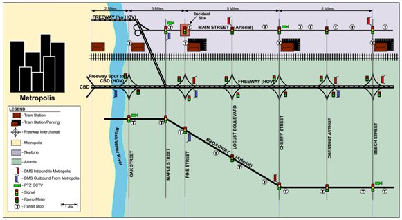
Figure 5-2. Minor Traffic Incident
In accordance with the pre-developed and approved ICM protocols, the lead transportation management role for such a "minor" incident is assumed by the jurisdiction/agency where the incident is located (i.e. Neptune DOT), with local police responsible for accident investigation and related enforcement activities. Related activities include:
- The Neptune police dispatcher contacts a patrol car near the scene via radio to proceed to the scene for investigation and on-scene management.
- Neptune DOT operators modify signal timing (e.g., increased cycle length) at the affected intersection to improve throughput given the blocked lanes. The increased cycle length is a multiple of the system cycle length so as to provide some degree of coordination.
- Neptune DOT operators contact a local towing company (from a list of approved companies) to obtain wrecker service to move the crash vehicles.
- The ASO for Neptune coordinates the Neptune DOT and police activities with other stakeholders within the Generic Corridor, providing the CCC with updates. This includes notifying the Generic Bus Authority of the incident and anticipated duration and impact. As a result of these discussions, it is determined to not reroute any Main Street Buses, but to modify the operational parameters for transit signal priority to maintain overall headways to the greatest extent possible. The State DOT is also contacted with information that the accident may increase outbound traffic in the Generic Corridor, possibly requiring a change in metering rates on selected ramps. Additionally, it is requested that a message regarding the incident be posted on the outbound freeway DMS near the Oak Street interchange.
- Neptune DOT operators continue to monitor the incident clearance process via CCTV, inputting new and revised information (arrival time of wreckers, estimated duration, incident cleared). This updated information is displayed on the various workstations (e.g., Police CAD, Generic Bus Authority, CCC) throughout the Generic Corridor.
Once the incident is cleared, Neptune DOT inputs an "all clear," but continues to monitor the traffic flow through the intersection, providing a "normal operation" status after the incident-induced queues have dissipated.
| ICM Strategies/Other Operational Details | Agency/Entity | Role and Responsibilities |
|---|---|---|
|
Information Sharing and Distribution (as in the "typical" scenario) Operational efficiency at network junctions (as in the "typical" scenario) A common incident reporting system and asset management (GIS) system En-route traveler information devices used to describe current operational conditions on another network(s) within the corridor.
Modify transit priority parameters to accommodate more timely bus service along Main Street Accommodate cross-network shifts shifts from arterial to freeway in advance of the intersection, including changes to ramp meter rates. |
CCC |
Monitor all conditions within corridor Coordination, particularly with Neptune DOT and police as to the accident investigation and clearance activities and status, ensuring that the Generic Bus Authority and State DOT are kept up-to-date on these activities. Coordination, ensuring accurate traveler information and the proper coordination of network junctions Suggest DMS messages along freeway and arterials regarding the crash and resulting delays. Suggest adjustments to network operating parameters to accommodate any impacts on the bus schedules (e.g., transit signal priority) and any route shifts from the arterial to the freeway (e.g., ramp meter rates) via Neptune, State DOT, and Generic Bus Authority ASOs. |
| State DOT | Monitor freeway sensors and CCTV Monitor/operate ramp meters, making changes per CCC suggestions Monitor/operate DMS, making changes per CCC suggestions |
|
| Neptune City | Lead role in terms of contacting wreckers to tow away vehicles, and updating information on the incident clearance activities and resulting delays at the intersection Coordinate all activities with the Neptune Police and their incident investigation and other on-scene activities Monitor arterial CCTV, particularly in vicinity of Main/Pine Monitor traffic sensors/volumes, modifying Main Street signal timings and transit signal priority parameters per CCC suggestions Monitor/operate DMS |
|
| Atlantis City | Monitor traffic sensors/volumes Monitor arterial CCTV Monitor signal operations Monitor/operate DMS |
|
| Generic Bus Authority | Monitor bus headways/schedules, identifying any problems as a result of the crash of the intersection (via ASO) Passenger counts |
|
| Regional Rail Agency | Monitor train headways/schedules Monitor parking availability Passenger counts |
|
| Emergency Services | Receive initial call(s) regarding crash, and enter into CAD On scene accident investigation |
5.3.2 Major Traffic incident Scenario
At 2:00 PM on a weekday, two eastbound tractor-trailers traveling along the freeway collide, knocking into and damaging an overpass bridge pier/structure at Locust Street. The accident and resulting damage has shut-down all eastbound lanes of the freeway, as well as Locust Street between Main and Broadway. The accident area covers approximately 300 feet of the freeway and will take approximately six hours to clear, well through the evening commute. Moreover, it is estimated that it will require a minimum of three days to assess and repair the damage to the bridge overpass structure, during which time the eastbound freeway lanes and Locust Street will remain closed to traffic.
During the initial evening peak, all outbound freeway traffic will be required to exit at Pine Street and reroute to Broadway or Main, and then travel along the arterials to Cherry to re-enter the freeway (or continue along the arterials to another freeway ramp). Once the incident is cleared, the State DOT will implement a temporary traffic control scheme; with both directions of the freeway traveling in the westbound lanes (two in each direction using the HOV lane and shoulders) and a reduced speed limit. The State DOT works overnight to secure traffic control and open the revised lane configuration by the morning commute. The freeway will remain constrained (two lanes in each direction within the westbound lanes) and Locust Street will remain closed until the investigation and repair work to the overpass structure is completed.
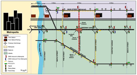
Figure 5-3. Major Traffic Incident
From the perspective of the ICMS and its decision support mechanism, this scenario involves three individual events - a short-term closure of the eastbound freeway with no advanced notice; a longer-term closure of the eastbound freeway with advance notice, and closure of a section of Locust Street in the vicinity of the freeway interchange. While all these scenarios have been incorporated into the decision support system, some manual alterations and decision making will be required to combine these into a unified and comprehensive response. The ICMS CCC is designated as the lead for coordinating the various responses to this major incident, including assuming "direct control" of DMS, arterial signal timing, and ramp metering rates via the ASOs for State DOT, Atlantis, and Neptune. Close coordination is also maintained between the CCC, the Regional Rail Agency and the Generic Bus Authority through their respective ASOs. Neither of the trucks involved in the incident were carrying hazardous materials, so it is determined that the Incident Command Structure does not need to be activated. Nevertheless, all traffic management activities and shifts are closely coordinated with the Police and other emergency services.
The initial activities and strategies in direct response to the accident are summarized below, with the longer-term activities summarized in Table 5-4.
- CCC — Coordinates with State DOT, Atlantis, and Neptune to establish the detours. Establishes required traveler information messages, including DMS transit, PA, and web, and promotes (and in some instances, instructs) route and modal shifts. Monitors traffic flows and delays on all roadway networks, initiating adjustments (i.e., direct control via the agency ASOs) to system operating parameters (e.g., signal timing for Broadway, Main, Pine, and Cherry; ramp metering rates and coordination with adjacent signals; transit signal priority parameters to improve bus operations vis-à-vis the published schedule; and best route messages on a portable DMS at the Pine Street off ramp so as to balance/equalize the delays) depending on actual traffic flows and route shifts, congestion, and bus delays. Contacts outlying parking facilities, initiating pre-arranged emergency contracts for additional parking, with shuttle service to the rail stations to be provided by Generic Bus Authority.
- State DOT — Contacts private company with appropriate towing vehicles to remove truck from the freeway. Also contacts the truck owners instructing them that they have 3 hours to arrive and off-load the trucks. Works with Atlantis to set up detour at Pine Street interchange, including a portable DMS on the off-ramp to provide information on the "best route" between the Broadway and Main Street detours. Posts the required messages on DMS (fixed and portable) per the CCC directions. Commences work on establishing the revised traffic pattern (i.e., two lanes in each direction using the westbound lanes).
- Atlantis — Works with the State DOT to set up detour at Pine Street Interchange. Coordinates with the CCC, monitoring the significant increase in traffic along Broadway, Pine, and Cherry, changing signal timing parameters and plans per CCC directions. Posts the required messages on DMS per the CCC directions.
- Neptune — Coordinates with the CCC, monitoring the significant increase in traffic along Main Street, Pine, and Cherry, changing signal timing parameters and plans per CCC directions. Posts the required messages on DMS per the CCC directions. Following discussions with the CCC, removes a work zone on Main Street (opening up all lanes to traffic early), and instructs the contractor not to close any part of the roadway for the next several days.
- Generic Bus Authority — Reroutes the Locust Street bus routes, and re-routes the express buses to Main Street. Coordinates with CCC regarding schedule adherence and transit signal priority. Commences preparation for providing shuttle bus service between temporary park and ride lots and rail stations (operation to start the next day and continue until the roadways are reopened).
- Regional Rail Agency — Makes announcements on station PA systems regarding roadway closures and rerouting of buses. Commences preparation for revised operations (additional transit vehicles/reduced headways) to start the next day and continue until the roadways are reopened.
- Police and Emergency Services — Provide on-scene incident investigation and flow management. Station police officers at key points along the detour routes (e.g., Pine Street interchange, intersections of Pine/Main Street, Pine/Broadway, Cherry/Main, Cherry/Broadway).
| ICM Strategies/Other Operational Details | Agency/Entity | Role and Responsibilities |
|---|---|---|
|
Information Sharing and Distribution (as in the "typical" scenario) Operational efficiency at network junctions (as in the "typical" scenario) A common incident reporting system and asset management (GIS) system En-route traveler information devices used to describe current operational conditions on another network(s) within the corridor.
Transit hub connection protection (particularly between regional rail and shuttle bus service) Multi-agency/multi-network incident response teams and service patrols (particularly in the area between Pine and Cherry St.) Coordinate scheduled maintenance and construction activities among corridor networks. Modify transit priority parameters to accommodate more timely bus service Modify arterial signal timing to accommodate traffic shifting from freeway (e.g., traveling to parking for transit, bypassing the constrained freeway traffic pattern) Modify ramp metering rates to accommodate shifted traffic returning to freeway Promote modal shifts from roadways to the rail transit network Increase capacity by using shoulders for traffic/opening the HOV lanes Contraflow operations Add transit capacity by adjusting headways and number of rail vehicles Add temporary new transit service (shuttle buses to temporary lots) Restrict freeway ramp access (closures) Restrict/reroute commercial traffic Peak spreading by outreach to media/commuters on ridesharing and telecommuting during repairs |
CCC |
Lead role in managing traffic throughout the corridor via ASOs Monitor all conditions within corridor (including performance measures) Coordination with all agencies, ensuring that all are kept up-to-date all activities and the potential impact on their respective operations. Coordination, ensuring accurate traveler information, including promoting ride sharing, telecommuting, etc. Coordination of network junctions, with particular emphasis on transit hub connection and transit signal priority Coordinate DMS messages throughout corridor regarding network operations/delays, and promoting shifts as appropriate. Initiate messages via ASOs. Initiate adjustments to network operating parameters to accommodate any route shifts between freeway and arterial and between freeway and transit parking (e.g., arterial signal timing, ramp metering rates, coordinated operation between meters and signals) via ASOs. Initiate adjustments to transit signal priority parameters to enhance bus operations (via ASOs). Coordinate with State Police regarding truck restrictions and rerouting. |
| State DOT |
Lead role in terms of dispatching incident team to set up and manage the contraflow operation of the freeway, including portable DMS and coordinating with the State police for enforcement and safety within the contraflow zone Variable speed limits within and on the approaches to the contraflow operation (via portable DMS) Provide additional freeway service patrols (in the vicinity of the contraflow zone) Monitor freeway sensors and CCTV, focusing on contraflow zone Monitor/operate ramp meters, making changes (per CCC) Monitor/operate DMS, making changes (per CCC) |
|
| Neptune City | Monitor traffic sensors/volumes Monitor arterial CCTV Monitor signal operations/adjust signal timing (per CCC) Monitor/operate DMS (per CCC) |
|
| Atlantis City | Monitor traffic sensors/volumes Monitor arterial CCTV Monitor signal operations/adjust signal timing (per CCC) Monitor/operate DMS (per CCC) |
|
| Generic Bus Authority | Provide shuttle bus service between rail stations and temporary parking lots Coordinate with Regional Rail Agency and CCC for connection protection Reroute express bus service as required Monitor bus headways/schedules Passenger counts |
|
| Regional Rail Agency | Coordinate with Generic Bus Authority and CCC for connection protection Add transit capacity by adding rail service (additional vehicles/reduced headways) Monitor train headways/schedules Monitor parking availability Passenger counts |
|
| Emergency Services | Regular operations/patrols The state police provide increased enforcement of contraflow zone, and enforce truck restrictions |
5.3.3 Minor Transit incident Scenario
At about 7:30 AM on a weekday, an express bus traveling from the Cherry Street Train Station to Metropolis breaks down in the HOV lane of the freeway, blocking the HOV lane. This minor transit incident will take approximately one to two hours for the response and clearance activities (i.e., dispatch another bus, transfer passengers, tow away disabled bus, clear the devices used for traffic management at the scene), and will cause congestion on the inbound freeway during the morning rush hour.
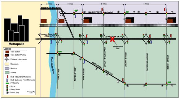
Figure 5-4. Minor Transit Incident Scenario
The bus driver notifies the dispatcher at the Generic Bus Authority TMC. The information is entered into the bus CAD, resulting in an incident alarm and map icon (and information regarding the incident) being activated on workstations at the CCC, State DOT, State Police, Regional Rail Agency and Neptune in accordance with the ICMS protocols. The ICMS also includes a plan for such an incident (as developed by the CCOO and ASOs, and approved by the GCOP), resulting in the following sequence of actions:
- State DOT is designated as the lead agency, with the ASO for the State DOT working closely and coordinating with the Generic Bus Authority and the State Police, as well as Neptune DOT and the Regional Rail Agency.
- A Generic Bus Authority wrecker and another bus and driver are dispatched to the incident site. The expected time of arrival (and the actual time) for these vehicles is input to the transit CAD by the bus dispatcher, and this information/updates are automatically displayed on the ICMS incident tracking screen on all workstations within the corridor.
- The State DOT dispatches a crew to set up a "safety zone" in the vicinity of the bus (to allow the passengers to safely get off the disabled bus and get on the replacement bus), including a portable DMS upstream of the incident. The State Police also dispatch a patrol car to the incident scene to assist with the on-scene management and enforcement. (This information and the associated arrival times are also input, with the ICMS incident tracking screen automatically updated).
- The Generic Bus Authority monitors traffic flow and travel times on the freeway and Main Street, and makes a decision as to whether the express bus service should be rerouted to Main Street. In the event the decision is made to reroute the express bus service, the ASO for the Generic Bus Authority notifies Neptune of the express bus route changes, and together work on modifying the transit signal priority parameters to minimize any schedule variations for the buses.
- The CCC coordinates traveler information, suggesting messages to be displayed on the State and Neptune DMS (in advance of Locust Street), and messages at the Beech and Cherry St. rail stations.
| ICM Strategies/Other Operational Details | Agency/Entity | Role and Responsibilities |
|---|---|---|
|
Information Sharing and Distribution (as in the "typical" scenario) Operational efficiency at network junctions (as in the "typical" scenario) A common incident reporting system Modify transit priority parameters to accommodate more timely express bus service along Main Street (as required) En-route traveler information devices used to describe current operational conditions on another network(s) within the corridor.
|
CCC |
Monitor all conditions within corridor (including performance measures) Coordination, particularly with Generic Bus Authority, State DOT and State Police (via ASOs), as to the response and clearance of the disabled, such that HOV lanes are reopened in a timely manner Coordination, ensuring accurate traveler information and the proper coordination of network junctions Coordinate and suggest DMS messages along freeway arterials regarding the HOV lane blockage and resulting delays. Coordinate and suggest DMS/PA messages at rail stations regarding the HOV lane blockage and the re-routing of express bus service, and potential delays. Coordinate with Neptune DOT and suggest adjustments to network operating parameters to accommodate any impacts on the express bus schedules (e.g., transit signal priority) Coordination occurs via the Neptune, State DOT, Generic Bus Authority, and Regional Rail Agency ASOs. |
| State DOT |
Lead role in terms of on-scene incident response and overall management Dispatch incident team to scene to set up safety zone, including portable DMS in advance of disabled bus Monitor freeway sensors and CCTV, focusing on congestion resulting from bus blockage Monitor/operate ramp meters Monitor/operate DMS, making changes per CCC suggestions Operate freeway service patrols |
|
| Neptune City |
Monitor arterial CCTV Monitor traffic sensors/volumes, modifying Main Street signal timings and transit signal priority parameters per CCC suggestions Monitor/operate DMS, making changes per CCC suggestions |
|
| Atlantis City |
Monitor traffic sensors/volumes Monitor arterial CCTV Monitor signal operations Monitor/operate DMS |
|
| Generic Bus Authority |
Dispatch replacement bus and wrecker to incident scene Input incident information and status into transit CAD Monitor bus headways/schedules Compare travel times on freeway and Main Street, re-routing express bus service as appropriate Passenger counts |
|
| Regional Rail Agency |
Monitor/operate in-stations DMS and PA, making changes per CCC suggestions Monitor train headways/schedules Monitor parking availability Passenger counts |
|
| Emergency Services | On scene support (safety) for transferring passengers between buses |
5.3.4 Major Transit Incident Scenario
Recent heavy rains have caused a stream running parallel to the railroad tracks to overflow its banks. This flooding has closed a section of track between the Cherry Street and Pine Street Stations - a situation that is expected to last at least three days. The CCC takes the lead role in coordinating the various corridor stakeholders and their respective activities and strategies in response to this incident (in accordance with the pre-approved ICMS plan). The primary strategies include the following:
- Generic Bus Authority: Provides a "bus bridge" along Main Street between the Cherry St and Pine St. Rail Stations; and also provides additional express bus service (i.e., reduced headways) during the AM and PM peak. The CCOO assigns the operational response lead to the ASO for the Generic Bus Authority as it will have the greatest impact on addressing the transit user service needs within the corridor.
- Regional Rail Agency: Allows the park & ride lots to be used for dynamic carpool creation.
- State DOT: Increases the HOV-lane requirements from HOV-2 to HOV-4 as a means to better accommodate the additional express bus service operating in these lanes,, and also opens the shoulder to traffic during the same periods (to accommodate the predicted increase in auto use). Also provides additional service patrols during the peak periods (as one of the shoulders will be used as a travel way.
- Neptune and Atlantis: Modifies the transit signal priority parameters to provide more timely bus service for the "bus bridge" operation and for the express bus service along Beech and Cherry Street (i.e., servicing the rail stations from the freeway).
- State Police: Enforcement of the revised HOV requirements.
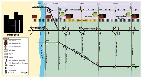
Figure 5-5. Major Transit Incident
| ICM Strategies/Other Operational Details | Agency/Entity | Role and Responsibilities |
|---|---|---|
|
Information Sharing and Distribution (as in the "typical" scenario) Operational efficiency at network junctions (as in the "typical" scenario) En-route traveler information devices used to describe current operational conditions on another network(s) within the corridor.
Modify transit priority parameters to accommodate more timely bus service Modify HOV restrictions (increase minimum number from 2 to 4) Increase roadway capacity by using shoulders for traffic (peak periods Add transit capacity (express bus service during peak periods) by adjusting headways and number of buses Add temporary new transit service (bus bridge between Cheery and Pine Street rail stations) Peak spreading by outreach to media/commuters on ridesharing and telecommuting during closure of the section of rail. |
CCC |
Lead role in coordinating the various ICM management strategies throughout the corridor via ASOs Monitor all conditions within corridor (including performance measures) Coordination with all agencies, ensuring that all are kept up-to-date all activities and the potential impact on their respective operations. Coordination, ensuring accurate traveler information, including promoting ride sharing, telecommuting, etc. Initiate adjustments to transit signal priority parameters to enhance bus operations (via ASOs). Coordinate with State Police regarding HOV enforcement |
| State DOT |
Provide additional freeway service patrols during peak periods (when shoulders are used as travel lanes) Monitor freeway sensors and CCTV, focusing on contraflow zone Monitor/operate ramp meters Monitor/operate DMS (including messages regarding revised HOV restrictions/use of shoulders) |
|
| Neptune City |
Monitor traffic sensors/volumes Monitor arterial CCTV Monitor signal operations/adjust signal timing (per CCC) Monitor/operate DMS |
|
| Atlantis City |
Monitor traffic sensors/volumes Monitor arterial CCTV Monitor signal operations/adjust signal timing (per CCC) Monitor/operate DMS |
|
| Generic Bus Authority |
Operational Lead Provide a "bus bridge" along Main Street between the Cherry St and Pine St. Rail Stations Provide additional express bus service (i.e., reduced headways) during the AM and PM peak. Monitor bus headways/schedules Passenger counts |
|
| Regional Rail Agency |
Monitor train headways/schedules Monitor parking availability Passenger counts |
|
| Emergency Services |
Regular operations/patrols The state police provide increased enforcement of HOV lanes and the revised requirements |
5.4 Major Planned Special Event Scenario
The Metropolis metropolitan area is abuzz about hosting the "championship" game at the new downtown stadium, located within the CBD. The pre-game events start at 5 PM, and parking downtown will be quite challenging since parking space availability will compete with the workforce up until about 6 PM. Moreover, many roads will be closed in and around the stadium.
As has been the case for other recent major events in Metropolis requiring special transportation management measures at both the regional and corridor level, a special event task force has been created to address the event's impact, looking at all aspects of venue management and security, including transportation. Planned special event management has typically included the establishment of a central command for transportation that is responsible for planning, preparations, and event-day operations command. With the implementation of the ICMS, this central command for the championship game will be aided by the CCC, with the BWR Transportation Operations Council assuming the lead for transportation-related planning and the development of operational strategies for the region (aided by the GCOP for management and operations within the Generic Corridor.
Working with the public safety agencies and stadium management, the BWRTOC determines that access to and from Metropolis during the day of the championship game should be transit-oriented — including during the AM commute — thereby minimizing traffic on the streets in the vicinity of the stadium during preparations. Security is also a concern, and it is determined that trucks will not be allowed access to the stadium area after 3 PM unless they have a special permit.
The various activities associated with managing this Special Event — public safety, security, transportation, etc. — will be conducted from the Emergency Operations Center (EOC) located in Metropolis. The CCOO (and selected ASOs) will operate the virtual CCC for the Generic Corridor from the EOC.
| ICM Strategies/Other Operational Details | Agency/Entity | Role and Responsibilities |
|---|---|---|
|
Information Sharing and Distribution (as in the "typical" scenario) Operational efficiency at network junctions (as in the "typical" scenario) En-route traveler information devices used to describe current operational conditions on another network(s) within the corridor. Coordinate scheduled maintenance and construction activities among corridor networks (i.e., no maintenance/construction activities the day of the event). Add transit capacity: additional trains/reduced headways during AM peak and prior to event (inbound), and additional trains/reduced headways during PM peak and after event (outbound) number of buses Add temporary new transit service (shuttle buses to/from temporary lots) Modify transit fares to encourage ridership Modify parking fees (increased in the Metropolis CBD; decreased at transit Park & Ride and temporary lots) Modify transit priority parameters to accommodate more timely bus service (shuttle buses) Promote modal shifts from roadways to the rail transit network Modify arterial signal timing to accommodate traffic shifting from freeway (e.g., traveling to parking for transit) Modify HOV restrictions (increase minimum number from 2 to 4) throughout the day Restrict freeway ramp access (closures) Restrict/reroute commercial traffic Peak spreading by outreach to media/commuters on ridesharing and telecommuting during the day of the event |
CCC |
Lead role in managing traffic throughout the corridor via the CCOO (located in the EOC) and ASOs, mitigating effects of special event. Coordinate implementation and operation of special event response plan Monitor all conditions within corridor (including performance measures), and adjust plans. Coordination with all agencies, ensuring that all are kept up-to-date on all activities and the potential impact on their respective operations. Coordination, ensuring accurate traveler information, including promoting transit use and telecommuting during the day of the event. Coordinate DMS messages throughout corridor regarding network operations/delays, and promoting shifts as appropriate. Initiate messages via ASOs. Initiate adjustments to network operating parameters to accommodate any route shifts between freeway transit parking (e.g., arterial signal timing, via ASOs. Initiate adjustments to transit signal priority parameters to enhance shuttle bus operations (via ASOs). Coordinate with State Police regarding truck restrictions and rerouting |
| State DOT |
Monitor freeway sensors and CCTV Monitor/operate ramp meters Monitor/operate DMS, making changes (per CCC) Close ramps (per CCC) |
|
| Neptune City |
Monitor traffic sensors/volumes Monitor arterial CCTV Monitor signal operations/adjust signal timing (per CCC) Monitor/operate DMS (per CCC) |
|
| Atlantis City |
Monitor traffic sensors/volumes Monitor arterial CCTV Monitor signal operations/adjust signal timing (per CCC) Monitor/operate DMS (per CCC) |
|
| Generic Bus Authority |
Provide shuttle bus service between rail stations and temporary parking lots Monitor bus headways/schedules Passenger counts |
|
| Regional Rail Agency |
Add transit capacity by adding rail service (additional vehicles/reduced headways) Reduce transit fares/parking fees Monitor train headways/schedules Monitor parking availability Passenger counts |
|
| Emergency Services |
Regular operations/patrols The state police provide increased enforcement of HOV lanes and enforce truck restrictions |
5.5 Evacuation Scenario
A category 4 hurricane is approaching Metropolis and the Governor has issued an evacuation order for the city and surrounding areas. Local officials have notified the ICMS stakeholders of a pending evacuation order for the region encompassing the integrated corridor. Based on previous modeling and analyses of such an emergency scenario (performed on a regional, statewide, and multi-state basis), it is well understood that the evacuation order will significantly impact all modes of transportation within the Generic Corridor, with the freeway facility being the primary route for the evacuation. Rail service to outlying stations combined with bus service from the stations to designated shelters (outside the zone of predicted storm surge) will also need to be provided for those residents who do not own cars.
Evacuation routes, designated shelters, and related emergency procedures have been identified as part of a statewide hurricane evacuation plan. This includes incorporation of the formal Incident Command System (ICS) management structure for controlling personnel, facilities, equipment, and communications. The GCOP has also developed an ICMS response plan that is aligned with this statewide plan (and is included as an annex to the plan). The hurricane evacuation scenario has also been the focus of several tabletop training exercises.
In accordance with the hurricane plan, the Emergency Operations Center (EOC) is activated for managing the evacuation, the storm impacts, and the aftermath. The State Police Captain for the Metropolis region is designated as the "Incident Commander." Located at the EOC, this individual has overall responsibility and command authority for the Metropolis Region, and also coordinates directly with the State Department of Emergency Services as well as with FEMA.

Figure 5-6. Evacuation Scenario
The CCC is designated the lead for implementing, coordinating and operating the transportation elements of the evacuation response plan within the Generic Corridor. The CCOO relocates to the EOC, reporting to the Incident Commander, and coordinates with all of the ASOs who oversee and coordinate the network-specific responses, including the following:
- State DOT: Set up contra-flow operations such that all lanes, including HOV and one shoulder, operate in the outbound direction; closing selected on-ramps, and reversing flow on several off-ramps (such that they become on ramps for the contra-flow operation). The State DOT also sends out safety patrols to pre-determined locations to provide operations assistance and respond to any problems.
- Regional Rail Authority: Discontinues the normal scheduled service, providing predominately outbound service with reduced headways. Fares are eliminated.
- Generic Bus Authority: Discontinues the normal scheduled service, providing shuttle bus service to the rail stations within Metropolis, Neptune, and Atlantis; and providing service from outlying stations to designated shelters. Fares are eliminated.
- Neptune and Atlantis: The inbound lanes on Broadway are converted to "police/emergency vehicle only" to facilitate the movement of emergency and rescue personnel and equipment into Metropolis and environs as needed. Pre-planned coordinated signal timing schemes are implemented that complement the contra-flow freeway operations. Transit signal priority parameters are implemented that favor the shuttle buses that service the regional rail stations.
| ICM Strategies/Other Operational Details | Agency/Entity | Role and Responsibilities |
|---|---|---|
|
Information Sharing and Distribution Operational efficiency at network junctions En-route traveler information devices used to describe current operational conditions on another network(s) within the corridor. Modify transit signal priority to accommodate buses serving the Regional Rail stations Signal pre-emption/"best route" for emergency vehicles (e.g., along Broadway). Transit hub connection protection (between regional rail service and shuttle buses) Multi-agency/multi-network incident response teams and service patrols A common incident reporting system Promote network shifts (use of freeway or regional rail/shuttle bus for evacuation) Add transit capacity by adjusting headways and number of transit vehicles (regional rail) Add temporary new transit service (shuttle bus service to regional rail stations, and from outlying stations to shelters) Contraflow freeway operations Open the freeway HOV lanes/shoulders Restrict/revise freeway ramp access (closures, reverse direction) Modify transit fares to encourage ridership Coordinate scheduled maintenance and construction activities among corridor networks (close down all such activities). |
CCC |
Lead role in managing traffic throughout the corridor via ASOs Monitor all conditions within corridor (including performance measures) Coordination with all agencies, ensuring that all are kept up-to-date all activities and the potential impact on their respective operations. Coordination with EOC/reporting to Incident Commander Coordination, ensuring accurate traveler information, including information on road closures/contraflow operations, revised transit service, infrastructure damage, debris removal, and restoration activities related to transportation systems and facilities. Assign appropriate personnel at key sites to oversee operations and to provide consistent, verified public information to emergency management agencies, public information officers, and the media. Coordination of network junctions, with particular emphasis on transit hub connection and transit signal priority Coordinate DMS messages throughout corridor regarding evacuation/network operations/delays, and promoting shifts as appropriate. Initiate messages via ASOs. Initiate adjustments to network operating parameters to accommodate any evacuations (e.g., arterial signal timing) via ASOs. Initiate adjustments to transit signal priority parameters to enhance bus operations (via ASOs). |
| State DOT |
Lead role in terms of setting up the contraflow operation of the freeway, including portable DMS Variable speed limits within and on the approaches to the contraflow operation (via portable DMS) Provide additional freeway service patrols Monitor freeway sensors and CCTV, Monitor/operate DMS, making changes (per CCC) |
|
| Neptune City |
Monitor traffic sensors/volumes Monitor arterial CCTV Monitor signal operations/adjust signal timing (per CCC) Monitor/operate DMS (per CCC) |
|
| Atlantis City |
Set up "emergency vehicle only" lanes on Broadway Monitor traffic sensors/volumes Monitor arterial CCTV Monitor signal operations/adjust signal timing (per CCC) Monitor/operate DMS (per CCC) |
|
| Generic Bus Authority |
Provide shuttle bus service to rail stations, and from outlying stations to shelters Coordinate with Regional Rail Agency and CCC for connection protection Monitor bus headways/schedules Passenger counts |
|
| Regional Rail Agency |
Coordinate with Generic Bus Authority and CCC for connection protection Add transit capacity by adding rail service (additional vehicles/reduced headways) to accommodate evacuation Monitor train headways/schedules Monitor parking availability Passenger counts |
|
| Emergency Services |
State Police assume overall lead role, working out of EOC. |
It is noted that this plan focuses only on the evacuation scenario. Additional plans have been developed for coordinating transportation clean-up and clearance activities (e.g., prioritize and perform emergency repairs); and for re-entry into the evacuated areas.
6 AS the GCOP consists of leadership level representatives from each of the stakeholders in the Generic Corridor, GCOP approval also constitutes approval of the individual stakeholders and their respective networks.
7 Measurement of Recurring Versus Non-Recurring Congestion: Technical Report, Technical Report and Final Report Research Project T2695; Washington State Transportation Center (TRAC); Washington State Transportation Commission, Department of Transportation and in cooperation with U.S. Department of Transportation Federal Highway Administration; October 2003